Mount Snowdon via Pyg Track - The Rugged Heart of Eryri
Mount Snowdon, known in the native Welsh tongue as Yr Wyddfa, stands as the crowning glory of the Eryri (Snowdonia) National Park. At 1,085 metres above sea level, it is the highest point in Wales and the most prominent peak in the British Isles outside of the Scottish Highlands. While there are six primary routes to the summit, the Pyg Track is widely regarded as the most dramatic and visually rewarding of the standard paths. Starting at the high mountain pass of Pen-y-Pass, this 11.7-kilometre return journey offers walkers an immediate immersion into a high-alpine environment, bypassing the long valley approaches of other routes. The track is a masterclass in glacial geology, carving a line beneath the towering cliffs of Crib Goch and providing unparalleled views of the deep blue glacial lakes of Llyn Llydaw and Glaslyn. It is a route that demands respect, offering a rugged, rocky underfoot experience that serves as a true introduction to Welsh mountaineering.
- Distance: 11.7 km return
- Elevation Gain: 975 m
- Duration: 5–7 hours
- Difficulty: Moderate to Hard (Rugged terrain with steep sections)
- Highest Point: 1,085 m (Yr Wyddfa Summit)
- Start/Finish: Pen-y-Pass Car Park
- Terrain: Well-maintained but rocky mountain paths, stone steps, and loose scree near the summit
Overview
The Pyg Track is often described as the "connoisseur's route" to the summit of Yr Wyddfa. Unlike the Llanberis Path, which follows the gentle gradient of the mountain railway, or the Miners Track, which begins with a flat lakeside stroll, the Pyg Track begins with a sharp, purposeful ascent from the very first step. Starting at an elevation of 359 metres at Pen-y-Pass, the trail immediately gains height, traversing the northern slopes of the Snowdon horseshoe. This elevated position ensures that walkers are treated to expansive views of the Glyderau mountain range to the north and the dramatic serrated ridge of Crib Goch directly above.
The character of the Pyg Track is defined by its ruggedness. The path is largely composed of pitched stone and natural rock, requiring constant attention to foot placement. It is a trail of two halves: the first section is a traversing climb to the pass of Bwlch y Moch, where the first breathtaking view of the summit and the lakes below is revealed. The second half involves a more technical traverse above the lakes, culminating in the famous "Zig-zags"—a series of steep, stone-walled switchbacks that bring walkers onto the main summit ridge. The final push to the summit cairn is shared with the Miners Track and the Llanberis Path, leading to the iconic circular stone plinth that marks the highest point in Wales.
What sets the Pyg Track apart is its proximity to the wilder elements of the mountain. It feels like a true mountain expedition, even though it is one of the most popular trails in the United Kingdom. On a clear day, the views extend across the Irish Sea to the Wicklow Mountains in Ireland and south towards the peaks of Cadair Idris. However, the mountain is notorious for its fickle weather; the Pyg Track can transform from a sun-drenched balcony to a wind-blasted, mist-shrouded challenge in a matter of minutes. This unpredictability is part of the Snowdon experience, making the eventual arrival at the summit—whether in glorious sunshine or atmospheric cloud—a significant achievement for any walker.
History and Cultural Context
The history of the Pyg Track is as layered as the volcanic rock through which it passes. The origins of its name remain a subject of spirited debate among local historians and mountaineers. Some suggest it is named after the "Pygau" (the hollows or crags) through which the path weaves. Others believe it takes its name from the Pen y Gwryd Hotel, located at the junction below Pen-y-Pass, where early mountaineers—including the team that first conquered Everest—stayed and trained. A more industrial theory suggests the name comes from "pyg," the Welsh word for pitch or tar, which was allegedly carried along the path for use in the copper mines that once dotted the mountain's flanks.
The track itself was significantly developed in the 19th century to facilitate the mining industry. Copper was extracted from the slopes of Snowdon, particularly around the shores of Glaslyn and Llyn Llydaw. The Pyg Track provided a higher, more direct route for miners and supervisors compared to the lower lakeside paths. As the mining industry waned in the late 1800s, the rise of Victorian tourism took its place. The mountain became a destination for "romantic" travellers seeking the sublime beauty of the Welsh wilderness. The Pyg Track, with its dramatic vistas and rugged character, became a favourite for those who wanted a more "authentic" mountain experience than the railway-assisted ascent from Llanberis.
Culturally, Yr Wyddfa is steeped in Welsh mythology. Legend has it that the summit is the tomb of Rhitta Gawr, a giant vanquished by King Arthur. The name "Yr Wyddfa" literally translates to "The Tumulus" or "The Burial Mound." The mountain is a symbol of Welsh identity and resilience, and the preservation of its Welsh name is a point of significant cultural pride. Today, the mountain is managed by the Eryri National Park Authority and the National Trust, who work tirelessly to balance the pressures of over half a million annual visitors with the need to protect the fragile upland environment and the local farming communities that have worked these slopes for centuries.
Want more background? Read extended notes on history and cultural context → Learn more
Seasonal Highlights and Weather Reality
The experience of walking the Pyg Track varies dramatically with the seasons, and understanding the weather reality of the Welsh mountains is crucial for a safe and enjoyable journey. In the height of summer (July and August), the track is a vibrant, social place. The weather is at its most stable, though "stable" in Eryri still allows for sudden rain. The mountain flora is in full bloom, including the rare Snowdon Lily (Lloydia serotina) if you know where to look on the high, inaccessible ledges. However, summer also brings extreme crowds; the summit can feel more like a busy city square than a wilderness peak.
Autumn (September to October) is arguably the best time to visit. The summer crowds dissipate, and the landscape is painted in deep ochres and burnt oranges as the grasses and ferns turn. The air is often crisper, providing better clarity for long-distance views. However, the days shorten rapidly, and the temperature at the summit can be 10 degrees Celsius lower than at Pen-y-Pass, often exacerbated by a biting wind chill.
Winter (November to March) transforms the Pyg Track into a serious mountaineering undertaking. While the path is easy to follow in summer, snow and ice can make the "Zig-zags" and the traverse above Glaslyn extremely hazardous. The "Killer Convex"—a slope near the summit where the path can disappear under a lethal sheet of ice—has claimed many lives. During these months, the Pyg Track should only be attempted by those with winter mountain skills, carrying ice axes and crampons. The weather can be ferocious, with winds exceeding 100 kilometres per hour and visibility dropping to zero in "whiteout" conditions.
Spring (April to June) is a season of transition. You may find yourself walking in warm sunshine at the start, only to encounter lingering snow drifts near the summit. The weather is notoriously fickle during this period, with "four seasons in one day" being a common occurrence. Always check the Mountain Weather Information Service (MWIS) before setting out, as the conditions at 1,000 metres bear little resemblance to the weather in the coastal towns of North Wales.
Recommended Itinerary

Mount Snowdon via Pyg Track Day Hike
Early Morning: The Ascent from Pen-y-Pass
- 08:00 – Arrive at Pen-y-Pass. If you have not pre-booked parking, ensure you have arrived via the Sherpa'r Wyddfa bus from Llanberis or Nant Peris.
- 08:15 – Start the climb. The Pyg Track begins at the far right-hand corner of the car park (looking away from the road).
- The first kilometre is a sharp ascent on a well-constructed stone path. This "wake-up call" quickly gains you about 100 metres of elevation.
- Pass through a series of kissing gates as the path levels out slightly, traversing the base of the Crib Goch ridge.
- Look back for views of the Glyderau peaks (Tryfan and Glyder Fach) across the valley.
Mid-Morning: Bwlch y Moch and the High Traverse
- 09:30 – Reach Bwlch y Moch (The Pass of the Pigs). This is a major landmark where the path crests a ridge.
- The view opens up spectacularly: the summit of Yr Wyddfa appears ahead, with the dark waters of Llyn Llydaw far below to your left.
- This is the junction for the Crib Goch scramble. Stay on the lower, left-hand path to remain on the Pyg Track.
- The path now traverses the hillside, maintaining a relatively steady altitude before beginning a gradual climb.
- The terrain becomes rockier here; watch your footing on the uneven stone slabs.
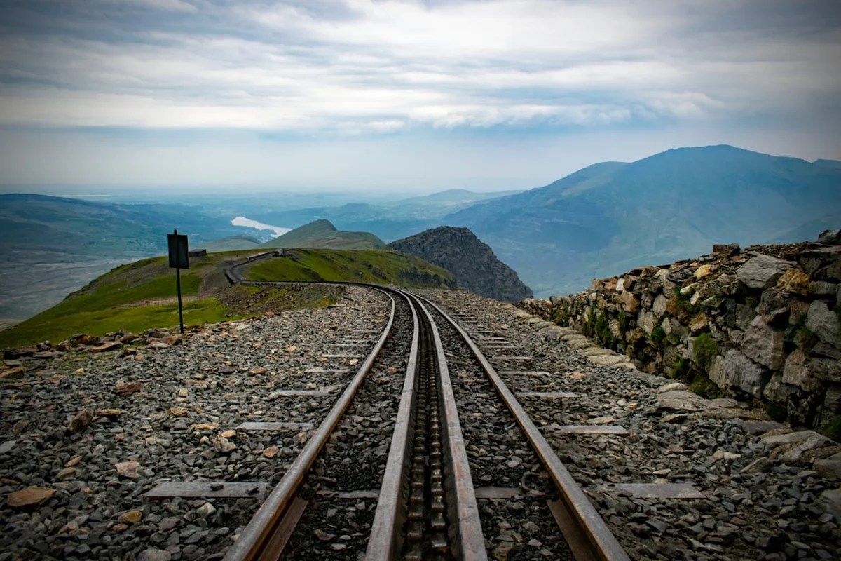
Late Morning: The Zig-zags and the Summit Ridge
- 10:45 – Reach the intersection with the Miners Track. The lower path joins from the left near the shores of Glaslyn.
- Begin the "Zig-zags." This is the steepest part of the hike, a series of tight switchbacks climbing the headwall above Glaslyn.
- The path is well-defined with stone steps, but it is physically demanding. Take frequent breaks to look back at the "Snowdon Horseshoe" panorama.
- 11:30 – Reach the Finger Stone. This large upright rock marks the point where the Pyg Track joins the Llanberis Path and the Snowdon Mountain Railway line on the summit ridge.
- Turn left for the final 15-minute walk along the ridge to the summit.
Midday: The Summit (Yr Wyddfa)
- 12:00 – Arrive at the summit (1,085 m). Climb the stone steps to the brass orientation plaque on the summit cairn.
- On a clear day, enjoy 360-degree views of North Wales, the Irish Sea, and potentially the Isle of Man.
- Visit Hafod Eryri, the summit visitor centre (open seasonally), for a coffee or to use the facilities.
- Find a sheltered spot away from the wind to eat your packed lunch.
Afternoon: The Descent
- 13:00 – Begin your descent. You have two main options: return via the Pyg Track for the views, or take the Miners Track for a change of scenery.
- If taking the Miners Track: Descend the Zig-zags back to the intersection, then follow the path down to the shores of Glaslyn.
- The Miners Track is flatter for the final 3 kilometres, passing Llyn Llydaw and the old copper mine workings.
- 15:30 – Arrive back at Pen-y-Pass.
- 16:00 – Board the Sherpa bus back to your base in Llanberis or Nant Peris.
Important Notes:
- The times provided are estimates for a moderate pace with breaks. Allow more time in poor weather or if you are less experienced.
- The summit visitor centre (Hafod Eryri) is usually closed from late October to late April.
- There is no water available on the track; you must carry all you need.
- Mobile signal is intermittent; do not rely on it for navigation.
Planning and Bookings
Book Your Trip
Everything you need to plan your journey
Accommodation
Find places to stay near Llanberis
Flights
Search flights to Llanberis
Essential Preparation
Preparation for Snowdon begins with logistics. The most critical factor is transport. Parking at Pen-y-Pass is extremely limited and must be pre-booked via the JustPark website or app. During the peak season (April to October), these spaces sell out weeks in advance. If you do not have a booking, do not attempt to drive to the trailhead; there is no alternative parking nearby, and the road is strictly patrolled with heavy fines and towing in operation.
The most effective way to access the Pyg Track is the Sherpa'r Wyddfa bus service. This excellent "Park and Ride" system operates from Llanberis and Nant Peris. You can park in the large long-stay car parks in these villages and take the S1 or S5 bus directly to the Pen-y-Pass entrance. This not only reduces congestion but also allows you the flexibility to walk up one side of the mountain and down another (e.g., up the Pyg Track and down the Llanberis Path).
Physically, the Pyg Track is a moderate to strenuous hike. While it does not require technical climbing skills, it does require a good level of cardiovascular fitness and steady balance on rocky, uneven ground. If you are not used to hill walking, consider a few training walks on smaller hills before attempting Yr Wyddfa.
Trail Accommodation
As the Pyg Track is a day hike, there is no overnight accommodation on the trail itself. However, there are several excellent options at the trailhead and in the surrounding valleys.
YHA Pen-y-Pass: Located directly at the start of the Pyg Track. This is a world-famous hostel, formerly a mountain hotel where early Everest pioneers stayed. It offers private rooms and dorm beds. It is highly recommended for those wanting an early start, but it must be booked months in advance for weekend stays.
Llanberis: The primary base for Snowdon walkers. This vibrant village offers a wide range of accommodation, from budget bunkhouses and campsites to mid-range hotels and luxury B&Bs. Llanberis also has the highest concentration of outdoor shops, restaurants, and pubs.
Nant Peris: A smaller village located between Llanberis and Pen-y-Pass. It features a popular campsite and the famous Vaynol Arms pub. It is a convenient stop for the Sherpa bus.
Wild Camping: Please note that wild camping is not legally permitted in the Eryri National Park without the explicit permission of the landowner. Most of the land surrounding the Pyg Track is actively farmed or managed for conservation, and wild camping is strongly discouraged to protect the environment.
Required Gear
- Walking Boots: Essential. The Pyg Track is very rocky. You need boots with good ankle support and a "Vibram" or similar high-grip sole. Trainers are unsuitable and increase the risk of ankle injuries.
- Waterproof Jacket and Trousers: Non-negotiable. Even if the forecast is clear, the summit is often in cloud and rain can move in rapidly. Gore-Tex or similar breathable fabrics are best.
- Layered Clothing: Use a layering system (base layer, fleece mid-layer, outer shell). Avoid cotton (like jeans or cotton t-shirts), as it stays cold and heavy when wet. Merino wool or synthetic "wicking" fabrics are ideal.
- Map and Compass: A physical map (OS Landranger 115 or Explorer OL17) and the ability to use it. GPS apps are useful but batteries fail in the cold.
- Survival Bag: A lightweight plastic bivvy bag (orange) can be a lifesaver if you are injured and have to wait for Mountain Rescue.
- Whistle: For signalling in an emergency (six blasts, one minute pause, repeat).
What to Bring
- Water: At least 2 litres per person. There are no reliable treated water sources on the mountain.
- Food: High-energy snacks (nuts, chocolate, dried fruit) and a substantial lunch. You will burn significantly more calories than on a flat walk.
- Sun Protection: Sunscreen and sunglasses. The UV levels are much higher at altitude, even on overcast days.
- Head Torch: Even if you plan to be down by 3:00 PM, a delay or injury could see you walking in the dark. Always carry a head torch with spare batteries.
- Power Bank: To keep your phone charged for emergency calls or navigation.
- Personal First Aid Kit: Including blister plasters (Compeed), antiseptic wipes, and any personal medication.
- Hat and Gloves: Even in summer, the summit wind chill can be freezing.
Permits
There are no permits required to walk on Mount Snowdon. Access to the mountain is free and protected under the Countryside and Rights of Way (CROW) Act. However, "permits" in the form of pre-booked parking are the biggest hurdle for most visitors.
Parking Permits (Pen-y-Pass):
- Parking at the Pen-y-Pass car park must be booked in advance during the summer season (typically April to October).
- Bookings are managed through the JustPark website/app.
- Costs are approximately £18 for 8 hours or £25 for 24 hours.
- Without a pre-booked digital permit, you will be turned away by staff at the entrance.
Organised Events: If you are planning a large charity walk or a commercial event (more than 10 people), you are encouraged to register your event with the Snowdonia National Park Authority. This helps them manage the impact on the mountain and ensures your group has the necessary safety information. There is usually no fee for this, but it is considered best practice for responsible mountain use.
Drone Permits: The use of drones on Snowdon is strictly controlled. To fly a drone for commercial purposes, you must have CAA authorisation and permission from the landowner (often the National Trust or the National Park). For recreational use, it is strongly discouraged due to the impact on wildlife and the privacy/peace of other walkers. In many areas of the Snowdon Horseshoe, drone flight is prohibited to protect nesting birds of prey.
Other Activities in the Area
The area surrounding Yr Wyddfa is a hub for outdoor adventure and Welsh culture. Consider these activities to round out your trip:
- Snowdon Mountain Railway: For those who want the view without the climb (or a ride down), this historic rack-and-pinion railway runs from Llanberis to the summit. It is a feat of Victorian engineering. Book well in advance.
- National Slate Museum (Llanberis): Located in the Victorian workshops of the Dinorwig Quarry, this free museum offers a fascinating look at the industry that "roofed the world" and shaped the culture of North Wales.
- Llanberis Lake Railway: A charming narrow-gauge steam train that runs along the shores of Llyn Padarn, offering great views of the mountains from a lower perspective.
- Electric Mountain: A tour of the Dinorwig Power Station, a massive pumped-storage hydroelectric scheme built inside a mountain. (Note: Check for reopening dates as tours are occasionally suspended for maintenance).
- Rock Climbing: Eryri is the birthplace of British rock climbing. Nearby areas like the Llanberis Pass and the Idwal Slabs offer world-class climbing for all abilities.
- Llyn Padarn Watersports: Hire a kayak or paddleboard on the glacial lake in Llanberis for a relaxing recovery session after your hike.
Safety and Conditions
Mountain Rescue: The Llanberis Mountain Rescue Team is one of the busiest in the UK. They are a volunteer organisation. In an emergency, dial 999, ask for the Police, and then ask for Mountain Rescue. Be prepared to give your location (ideally using a grid reference or a "What3Words" address).
The "Killer Convex": This is a specific area on the upper slopes where the Pyg Track and Miners Track meet the summit ridge. In winter, the slope becomes convex and icy. If a walker slips here, they can slide several hundred metres into the cliffs above Glaslyn. Never attempt this section in winter without full alpine gear.
Weather Monitoring: Do not rely on general weather forecasts for towns like Bangor or Caernarfon. Use the Met Office Mountain Forecast or the Mountain Weather Information Service (MWIS). These provide specific data on "Feels Like" temperatures, wind speeds at 1,000m, and the probability of cloud-free summits.
Navigation: The Pyg Track is generally well-marked, but in thick mist (which occurs on roughly 300 days a year on the summit), it is very easy to wander off-path. The terrain surrounding the track is steep and contains many hidden cliff drops. Always carry a map and compass and know how to use them to find your way back to the path.
Dehydration and Exhaustion: Many rescues on Snowdon are due to simple exhaustion or dehydration. The climb is a significant physical effort. Pace yourself, eat regularly, and drink plenty of water. If you feel unwell, do not be afraid to turn back. The mountain will still be there tomorrow.
Side Trips and Points of Interest
Crib Goch: For the experienced and sure-footed, the Crib Goch ridge is the ultimate Snowdon side trip. It branches off the Pyg Track at Bwlch y Moch. It is a Grade 1 scramble across a "knife-edge" ridge with massive drops on both sides. It should never be attempted by beginners, those with a fear of heights, or in windy/wet conditions. It is a serious mountaineering route that requires the use of hands.
The Miners Track Descent: Instead of returning the way you came, descend via the Miners Track. This allows you to see the old crushing mills and barracks of the Britannia Copper Mine. The path takes you right to the edge of Llyn Llydaw, where you can see the remains of the causeway built by the miners. It is a gentler, more historical end to the day.
Llyn Glaslyn: According to Welsh folklore, this deep, cold lake is the home of the "Afanc," a mythical water monster. It is also said that King Arthur's sword, Excalibur, was thrown into these waters. It is a beautiful, atmospheric spot to stop for a break during the ascent.
The Finger Stone: This large standing stone at the top of the Zig-zags is a famous meeting point. It is actually a waymarker designed to help walkers find the descent path in bad weather. Ensure you identify it clearly so you know where to turn off the ridge for your return journey.
Leave No Trace
With over 500,000 people standing on the summit of Yr Wyddfa every year, the environmental impact is immense. The "Leave No Trace" principles are not just suggestions here; they are essential for the survival of the mountain's ecosystem.
Litter: Pack out every single piece of rubbish, including "biodegradable" items like banana skins and orange peels. In the cold, acidic environment of the mountain, these can take years to decompose and are an eyesore for others. The "Real 3 Peaks Challenge" volunteers collect tonnes of rubbish from the mountain every year—don't add to it.
Path Erosion: Stay on the constructed path. Taking shortcuts on the Zig-zags causes "braiding," where multiple paths form, leading to massive soil erosion and the destruction of rare alpine plants. The stone paths are there to protect the mountain; please use them.
Human Waste: Use the toilets at Pen-y-Pass or the summit visitor centre (when open). If you are caught short, ensure you are at least 50 metres from any water source and bury waste deeply. Carry out all toilet paper in a sealed bag.
Wildlife: Do not feed the birds at the summit. The seagulls and ravens have become habituated to human food, which is detrimental to their health and makes them aggressive towards walkers.