
Mount Siguniang Trek - The Alps of the East
The Mount Siguniang Trek is China’s premier high-altitude mountain journey—a 50-kilometre expedition through the Qionglai Mountains of Western Sichuan. Known as the "Alps of the East," this trek traverses the dramatic Changping and Bipeng Valleys, offering an unparalleled window into the rugged beauty of the Hengduan mountain system. The route is dominated by the four iconic peaks of Siguniangshan (Four Sisters Mountain), culminating in the majestic Yaomei Feng, which pierces the sky at 6,250 metres. This is not merely a walk; it is a high-altitude traverse that bridges two distinct ecological zones, moving from the lush, moss-draped forests of the Changping Valley over a formidable 4,668-metre alpine pass into the stark, glaciated landscapes of Bipeng Valley. For trekkers, it represents a profound challenge of endurance and acclimatisation, rewarded by views of granite spires, turquoise alpine lakes, and the deep cultural heritage of the Gyarong Tibetan people.
- Distance: 50.0 km (point-to-point traverse)
- Duration: 3–5 days
- Elevation Gain: 2,500 m
- Highest Point: Kaza Pass (4,668 m)
- Difficulty: Challenging (High altitude and steep terrain)
- Best Time: May–June (wildflowers) and September–October (autumn colours)
- Closest City: Chengdu, Sichuan Province, China
- Trailhead Access: Rilong Town (Siguniangshan Town) via Changping Valley
Overview
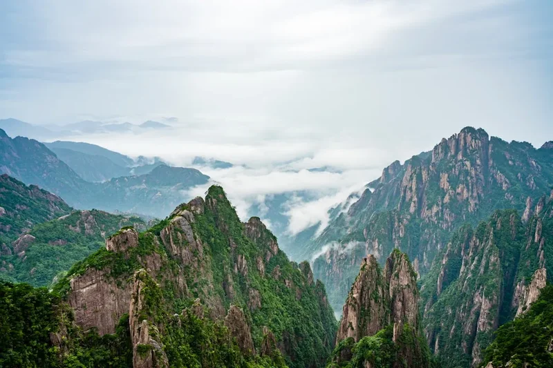
The Mount Siguniang Trek is a masterclass in topographical diversity. The journey typically begins in the Changping Valley, a long, glaciated corridor that serves as the gateway to the southern faces of the Four Sisters. The four peaks—Dafeng (Big Peak, 5,025 m), Erfeng (Second Peak, 5,276 m), Sanfeng (Third Peak, 5,355 m), and the "Queen of Sichuan Peaks," Yaomei Feng (Youngest Sister, 6,250 m)—form a staggering backdrop that evolves with every kilometre travelled. While the peaks themselves are the domain of mountaineers, the trekking route skirts their bases, providing a scale of landscape that is difficult to comprehend until one stands beneath the 2,000-metre vertical granite walls of Yaomei Feng.
The trek is defined by its transition. The first two days are spent ascending through ancient forests of larch, cypress, and rhododendron, where the air is thick with the scent of pine and the sound of the Changping River. As the elevation surpasses 4,000 metres, the forest gives way to alpine meadows and eventually to the raw, scree-covered world of the high passes. The crossing of the Kaza Pass (also known as the Changping-Bipeng Pass) is the physical and emotional crux of the journey. At nearly 4,700 metres, oxygen is thin, and the weather is unpredictable, but the panoramic view from the crest—looking back at the Four Sisters and forward into the glaciated cirques of Bipeng Valley—is one of the most spectacular sights in the Chinese wilderness.
This region is part of the Sichuan Giant Panda Sanctuaries, a UNESCO World Heritage site. While the elusive pandas are rarely seen by trekkers, the biodiversity is immense. You are walking through a landscape that serves as a refuge for rare flora and fauna, including the red panda, golden monkey, and various species of pheasant. The trek requires a high level of physical fitness and, crucially, a disciplined approach to acclimatisation. Starting from Chengdu at 500 metres and reaching nearly 4,700 metres within three days is a significant physiological leap that demands respect and preparation.
History and Cultural Context
The history of Mount Siguniang is inextricably linked to the Gyarong Tibetans, a distinct subgroup of the Tibetan people who have inhabited the valleys of Western Sichuan for over a millennium. To the local people, the four peaks are not merely geological formations but the physical embodiment of four sisters who fought a legendary general to protect their people, eventually turning into mountains to block his path. This spiritual connection is visible throughout the trek: colourful prayer flags flutter at high passes, mani stones (stones carved with Buddhist mantras) are piled at trail junctions, and the architecture of Rilong Town reflects the unique stone-masonry traditions of the Gyarong culture.
In the modern era, Mount Siguniang gained international fame in the 1980s as a premier mountaineering destination. Yaomei Feng, with its technical ice and rock faces, remains one of the most coveted and difficult climbs in China, often compared to the Eiger or the Matterhorn. The trekking route between Changping and Bipeng Valleys was historically a trade and pilgrimage route, used by locals to move livestock and goods between the different valley systems. It was only in the last two decades that it became a formalised trekking route for outdoor enthusiasts.
The establishment of the Mount Siguniang National Park and its subsequent inclusion in the UNESCO World Heritage list in 2006 marked a turning point for the region. Conservation efforts have been balanced with the development of sustainable tourism, ensuring that the "Alps of the East" remain protected while allowing trekkers to experience their majesty. Today, the trek is a symbol of China's growing outdoor culture, blending ancient Tibetan traditions with modern mountain exploration.
Want more background? Read extended notes on history and cultural context → Learn more
Seasonal Highlights and Weather Reality
The weather in the Qionglai Mountains is influenced by the high-altitude plateau climate and the East Asian monsoon, creating distinct windows for trekking. Understanding these seasons is critical for safety and enjoyment.
Spring (May to June): This is the season of rebirth. As the winter snow melts, the valleys erupt in a carpet of wildflowers. The rhododendron forests, some of the most diverse in the world, bloom in shades of pink, white, and red. While the weather is generally stable, afternoon showers are common, and snow may still linger on the high passes, requiring gaiters and occasionally micro-spikes. Temperatures range from 5°C to 15°C in the valleys, dropping well below freezing at night at higher camps.
Autumn (September to October): Widely considered the best time to trek. The monsoon rains subside, leaving behind crisp, clear air and exceptional visibility—perfect for photographing the granite peaks. The larch and birch trees turn brilliant shades of gold and orange, contrasting sharply against the blue sky and the white glaciers. This is also the busiest season, so expect more company on the trail. Temperatures are cooler than in spring, with night-time temperatures at base camp often reaching -5°C or -10°C.
Summer (July to August): The monsoon season brings heavy rain, frequent mist, and a higher risk of landslides. While the landscape is incredibly lush and green, the peaks are often shrouded in cloud for days at a time. Leeches can be a nuisance in the lower, wetter sections of the forest. Trekking is possible but requires high-quality waterproof gear and a flexible itinerary.
Winter (November to April): The region becomes a true alpine wilderness. Heavy snow renders the Kaza Pass impassable for standard trekking, and temperatures can plummet to -20°C. This season is reserved for ice climbing and technical winter mountaineering. Most trekking operators cease operations during this period due to the extreme cold and avalanche risk.
Recommended Itinerary
4-Day Changping to Bipeng Traverse
Day 1: Rilong Town to Muluo Settlement
- Distance: 12 km
- Elevation gain: 400 m
- Time: 4–5 hours
- Start at the Changping Valley entrance (3,200 m)
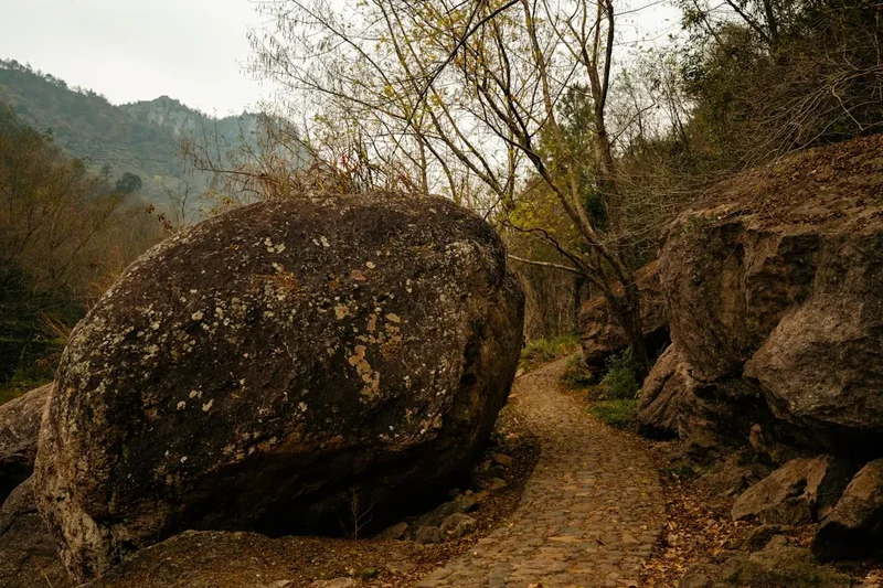
- Walk along the wooden boardwalk for the first 5 km, passing Lama Monastery
- Transition to a dirt trail through dense cypress and larch forests
- Views of the southern faces of Dafeng and Erfeng
- Arrive at Muluo (3,600 m), a flat meadow area used for camping
- Easy first day to assist with acclimatisation
Day 2: Muluo Settlement to Chazi Valley Base Camp
- Distance: 14 km
- Elevation gain: 350 m
- Time: 5–6 hours
- Continue up the Changping Valley following the river
- The forest thins out, revealing the massive pyramid of Yaomei Feng
- Pass through "The Dead Tree Forest," a hauntingly beautiful area of bleached trunks in a turquoise lake
- Cross several small streams and glacial moraines
- Arrive at Chazi Valley Base Camp (3,950 m) at the foot of the pass
- Early night recommended to prepare for the pass crossing
Day 3: Chazi Valley to Bipeng Valley via Kaza Pass
- Distance: 12 km
- Elevation: 718 m gain to pass, 900 m descent
- Time: 8–10 hours
- The most challenging day of the trek
- Steep, relentless ascent on scree and rock to Kaza Pass (4,668 m)
- Spectacular 360-degree views of the Siguniang massif and Bipeng glaciers
- Steep descent on the north side, often involving snow patches or loose scree
- Enter the upper Bipeng Valley, characterised by sharp peaks and hanging glaciers
- Arrive at the Bipeng Valley camping area (3,750 m)
Day 4: Bipeng Valley to Li County and Chengdu
- Distance: 12 km
- Elevation: 400 m descent
- Time: 4–5 hours
- Gentle descent through the scenic Bipeng Valley National Park
- Pass alpine lakes like Moon Lake and Redwood Forest
- Board the park shuttle bus at the end of the trail
- Transfer to a private vehicle or public bus in Li County
- Return drive to Chengdu (approx. 4-5 hours)
Important Notes:
- A local guide is mandatory for the Changping to Bipeng traverse
- Pack animals (horses/mules) are commonly used to carry heavy gear
- Acclimatisation days in Rilong (3,200 m) before starting are highly recommended
- Water must be treated; do not drink directly from the river
- Weather at Kaza Pass can change in minutes; always carry a hard shell jacket
Planning and Bookings
Book Your Trip
Everything you need to plan your journey
Accommodation
Find places to stay near Chengdu
Flights
Search flights to Chengdu
Essential Preparation
The Mount Siguniang Trek requires significant logistical coordination, primarily because it is a point-to-point traverse ending in a different valley system. Most trekkers base themselves in Chengdu, the capital of Sichuan Province, which is well-connected by international flights. From Chengdu, you must travel to Rilong (now officially named Siguniangshan Town), a journey of 220 kilometres that takes 4 to 6 hours via the Balang Shan tunnel. It is essential to spend at least one or two nights in Rilong (3,200 m) to acclimatise before heading higher.
Physical fitness is paramount. You should be comfortable walking 6–8 hours a day with a daypack at high altitudes. Cardiovascular training and hill walking in the months leading up to the trek are strongly advised. Additionally, because the trek ends in Bipeng Valley (Li County), you must arrange for your main luggage to be transported from Rilong to the exit point or back to Chengdu, as pack horses generally do not cross the high pass.
Trail Accommodation
Accommodation on the Mount Siguniang Trek is rugged and primarily involves camping. There are no luxury lodges or heated huts once you leave the trailhead at Changping Valley.
Camping and Shelters:
- Campsites: Designated flat areas like Muluo and Chazi Valley. These are basic clearings with no facilities other than proximity to water sources.
- Stone Shelters: Some campsites have basic stone huts used by local herders or guides. These are drafty and often dirty; they should be viewed as emergency shelters rather than primary accommodation.
- Rilong Accommodation: The town offers a range of options from basic Tibetan guesthouses to mid-range hotels. Most provide hot water and electric blankets, which are essential in the cold mountain nights.
What is NOT Provided:
- Tents, sleeping bags, and mats (must be brought or rented from an outfitter in Rilong).
- Toilet facilities (trekkers must use "cat holes" and follow LNT principles).
- Electricity or charging stations (power banks are essential).
- Running water (all water is sourced from streams and must be filtered or boiled).
Required Gear
- High-altitude boots: Waterproof, well-insulated, and with a stiff sole for scree slopes.
- Hard-shell jacket and trousers: Gore-Tex or equivalent to protect against high-altitude wind and sudden snow.
- Down jacket: A high-loft jacket (rated to -15°C) for evenings at camp.
- Sleeping bag: A 4-season down bag with a comfort rating of at least -10°C.
- Backpack: A 30-40L daypack if using pack horses, or a 65L+ pack if carrying your own gear.
- Trekking poles: Essential for the steep descent from Kaza Pass to protect knees.
- Headlamp: With extra batteries; camp life starts and ends in the dark.
- Gaiters: To keep snow and scree out of your boots during the pass crossing.
What to Bring
- High-calorie food: Dehydrated meals, nuts, chocolate, and energy bars. Digestion slows at altitude, so bring foods you find easy to eat.
- Water treatment: A high-quality filter (like a Sawyer Squeeze) or UV purifier (Steripen).
- Sun protection: SPF 50+ sunscreen, lip balm with SPF, and Category 4 sunglasses (glacier glasses) to prevent snow blindness.
- Personal medical kit: Including Diamox (for altitude), Ibuprofen, blister pads, and rehydration salts.
- Toiletries: Biodegradable wet wipes, hand sanitiser, and a small trowel for waste.
- Thermal layers: Merino wool base layers (top and bottom) are superior for odour control and warmth.
- Power bank: Large capacity (20,000mAh) to keep phones and cameras charged in the cold.
Permits
Navigating the permit system for Mount Siguniang can be complex for international travellers due to changing regulations and the requirement for local registration. As of the current season, all trekkers entering the Changping Valley for the traverse must register at the Siguniangshan National Park office in Rilong.
Permit Requirements:
- Park Entry Fee: Approximately 70–90 RMB for Changping Valley and a separate fee for Bipeng Valley (approx. 80 RMB).
- Trekking Permit: A specific "Outdoor Activity Permit" is required for the traverse. This is obtained at the Outdoor Management Centre in Rilong.
- Mandatory Guide: For the Changping to Bipeng traverse, the park authorities require that you are accompanied by a certified local guide. They will handle the bulk of the permit paperwork for you.
- Insurance: You must show proof of insurance that covers high-altitude trekking and emergency evacuation.
Logistics and Costs:
- Guide Fees: Expect to pay 300–500 RMB per day for a local guide.
- Pack Horses: Approximately 200–300 RMB per horse per day. One horse can typically carry the gear of two trekkers.
- Registration: You must provide a copy of your passport and Chinese visa. Note that certain areas of Western Sichuan may occasionally be closed to foreigners; always check the current status with a local agency before departing Chengdu.
Other Activities in the Area
The region surrounding Mount Siguniang offers a wealth of outdoor and cultural experiences that can be added to your itinerary:
- Peak Climbing (Dafeng and Erfeng): For those looking to stand on a summit, Dafeng (5,025 m) and Erfeng (5,276 m) are considered "trekking peaks." They require no technical climbing skills in good weather but offer a true high-altitude mountaineering experience.
- Haizi Valley Trek: A sister valley to Changping, Haizi Valley is famous for its numerous alpine lakes (Haizi) and offers some of the best panoramic views of the Four Sisters massif from a distance.
- Wolong Giant Panda Reserve: Located on the drive between Chengdu and Rilong, this is one of the best places in the world to see giant pandas in a semi-natural environment and learn about conservation efforts.
- Jiarong Tibetan Villages: Visit the nearby town of Danba to see the famous "Jiarong Tibetan Watchtowers," ancient stone structures that dot the hillsides of the Dadu River valley.
- Ice Climbing: In the winter months (December to February), the frozen waterfalls of Shuangqiao Valley become a world-class destination for ice climbers of all levels.
Safety and Conditions
Acute Mountain Sickness (AMS): This is the primary safety concern. The trek reaches 4,668 metres, an altitude where oxygen levels are significantly lower than at sea level. Symptoms include headache, nausea, dizziness, and fatigue. The best prevention is a slow ascent. Spend at least two nights at 3,200 metres before starting. If symptoms persist or worsen, the only cure is immediate descent. Carry Diamox if prescribed by your doctor, and stay well-hydrated.
Weather Extremes: High-altitude weather is notoriously fickle. Even in summer, a clear morning can turn into a blizzard by afternoon. Hypothermia is a genuine risk if you are caught in wet, windy conditions without proper layers. Always keep your waterproofs and a warm layer in your daypack, regardless of how the sky looks at breakfast.
Terrain Hazards: The ascent and descent of Kaza Pass involve loose scree and potentially steep snow slopes. Slips and falls are common. Trekking poles are highly recommended to maintain balance. In the lower valleys, river crossings can be tricky after heavy rain; always follow your guide’s lead on where to cross.
Communication: There is no mobile signal once you are deep in the Changping Valley. Your guide may carry a satellite phone or a radio, but you should not rely on personal devices for emergency contact. Ensure someone in Chengdu or at home knows your itinerary and expected exit date.
Emergency Evacuation: Helicopter rescue is extremely limited and often unavailable in this region. Evacuation is typically done by horse or stretcher to the nearest road head, which can take 24 hours or more. This underscores the importance of conservative decision-making and having comprehensive travel insurance.
Side Trips and Points of Interest
The Dead Tree Forest (Kushu Lin): Located in the Changping Valley, this is one of the most photographed spots on the trek. Hundreds of ancient larch trees were submerged when a natural dam formed a lake; their bleached, skeletal remains now stand in the turquoise water, framed by the snow-capped peaks. It is a hauntingly beautiful place to stop for lunch on Day 2.
Lama Monastery (Galsang Monastery): Situated near the entrance of Changping Valley, this small Tibetan Buddhist monastery provides a spiritual anchor to the trek. It is traditional to walk around the monastery in a clockwise direction (kora) to seek blessings for a safe journey over the mountains.
Redwood Forest (Hongshan Lin): As you descend into Bipeng Valley on Day 4, you pass through a stunning forest of ancient redwoods and larches. In autumn, the needles turn a fiery red-orange, creating a spectacular contrast with the grey granite cliffs and white glaciers above.
Moon Lake and Five-Coloured Lake: These alpine tarns in the Bipeng Valley are famous for their clarity and the way they reflect the surrounding peaks. The mineral content in the water creates vibrant hues of green, blue, and turquoise, particularly striking in the midday sun.
Leave No Trace
The Mount Siguniang region is a fragile high-altitude ecosystem that is under increasing pressure from tourism. As a trekker, you have a responsibility to minimise your impact on this UNESCO World Heritage site.
Core Principles for Siguniang:
- Pack it in, pack it out: This includes all trash, even organic waste like orange peels and nut shells, which decompose very slowly at high altitudes.
- Dispose of waste properly: Use the "cat hole" method for human waste, at least 60 metres from water sources. Pack out all used toilet paper in a sealed bag.
- Respect the wildlife: Do not feed or approach any animals, including the marmots and birds. Feeding them disrupts their natural foraging habits and can make them dependent on humans.
- Stay on the trail: The alpine tundra is incredibly slow to recover. A single footprint off-trail can destroy plants that have taken years to grow.
- No fires: Use a camp stove for cooking. Wood is scarce at high altitudes, and the risk of forest fires in the dry larch forests is high.
- Respect cultural sites: Do not touch or remove mani stones or prayer flags. These are sacred objects to the local Tibetan people.