Mount Rinjani Trek - The Sacred Peak of Lombok
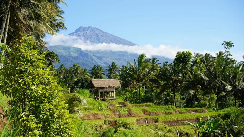
Mount Rinjani, or Gunung Rinjani, is an active stratovolcano that dominates the landscape of Lombok, Indonesia. Rising to a staggering 3,726 metres, it is the second-highest volcano in Indonesia and represents one of the most challenging yet rewarding trekking experiences in Southeast Asia. The trek is a 55 km journey that traverses diverse ecosystems, from lush tropical rainforests and expansive savannahs to the stark, lunar-like landscapes of the volcanic summit. At the heart of the massive 6 km by 8.5 km caldera lies Segara Anak, a breathtaking turquoise crater lake that sits 2,000 metres above sea level, featuring the active sub-volcano, Gunung Baru Jari, at its centre. This is not merely a physical challenge; it is a pilgrimage through a landscape of profound spiritual significance to the local Sasak and Balinese people, offering a raw encounter with the geological power of the Ring of Fire.
- Distance: 55.0 km (full circuit from Sembalun to Senaru)
- Duration: 3–4 days
- Season: April to October (dry season; the park is typically closed from January to March)
- Accommodation: Tents (camping at designated crater rim and lake sites)
- Highest point: Rinjani Summit (3,726 m)
- Elevation Gain: Approximately 2,600 m total ascent
- Difficulty: Challenging (requires high physical fitness and mental resilience)
- Access: Mandatory trekking guides and porters for all international visitors
Overview
The Mount Rinjani trek is frequently cited as one of the premier mountain adventures in the world, offering a dramatic vertical progression that few other trails can match. The journey typically begins in either the village of Sembalun (1,156 m) or Senaru (601 m), each providing a distinct perspective on the mountain. Starting from Sembalun involves a long trek through rolling grasslands and savannahs, exposed to the tropical sun, before a punishing ascent to the crater rim. Conversely, the Senaru route climbs through dense, humid rainforest where the canopy provides shade but traps the heat, offering glimpses of rare ebony monkeys and exotic birdlife. Regardless of the starting point, the trek culminates in the awe-inspiring sight of the caldera—a massive volcanic bowl that contains a lake of impossible blue and a smoking cone that serves as a constant reminder of the earth's internal heat.
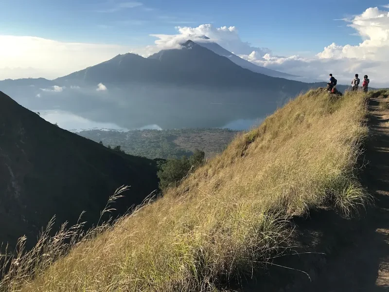
The physical demands of Rinjani are significant. The ascent to the summit is a notorious "two steps forward, one step back" struggle on deep volcanic scree and ash. This final push usually begins at 2:00 AM in freezing temperatures, as trekkers aim to reach the peak for a sunrise that illuminates the entire island of Lombok, the neighbouring Gili Islands, and even the distant silhouette of Mount Agung on Bali. The descent into the caldera to reach the shores of Segara Anak is equally demanding, requiring careful footwork on steep, rocky paths. However, the reward is a stay at the lakeside, where natural hot springs provide a therapeutic soak for weary muscles and the sheer walls of the caldera tower overhead, creating a sense of isolation and grandeur that is truly humbling.
Beyond the physical landscape, Rinjani is a cultural icon. For the Sasak people, the mountain is a source of life-giving water for the island's agriculture. For Balinese Hindus, the lake is a sacred site where offerings are made to the mountain spirits. This spiritual weight is palpable throughout the trek, from the small shrines found along the path to the reverent silence of the porters as they navigate the higher reaches. To walk Rinjani is to participate in a tradition of mountain worship that spans centuries, set against a backdrop of world-class geological drama.
History and Cultural Context
The geological history of Mount Rinjani is defined by one of the most cataclysmic events in human history. In 1257, the Samalas volcano (the precursor to the modern Rinjani complex) erupted with such force that it is believed to have triggered a global "year without a summer" and contributed to the onset of the Little Ice Age. This eruption was significantly larger than the famous 1883 eruption of Krakatoa, ejecting massive volumes of ash into the stratosphere and leaving behind the enormous caldera we see today. The modern peak of Rinjani and the smaller cone of Baru Jari are subsequent formations within this ancient collapse structure. Understanding this history adds a layer of profound respect for the landscape; trekkers are walking on the site of a geological event that literally changed the world's climate.
Culturally, Rinjani is known as "Dewi Anjani," named after a legendary queen who is said to rule over the mountain spirits. The Sasak people, the indigenous inhabitants of Lombok, believe the mountain is the dwelling place of gods and ancestors. Every year, thousands of pilgrims make the journey to the crater lake for the "Pekala" ceremony, where they pray for rain and fertility for their crops. The Balinese also hold the mountain in high esteem, performing the "Mulang Pakelem" ceremony, which involves placing gold and jewellery into the lake as offerings to the supreme deity. This dual religious significance makes Rinjani a unique intersection of Islamic-influenced Sasak traditions and Balinese Hinduism.
The history of trekking on Rinjani began in earnest during the Dutch colonial era, with early European explorers documenting the ascent in the 19th century. However, it wasn't until the establishment of the Gunung Rinjani National Park (Taman Nasional Gunung Rinjani) in 1997 that the mountain became a formalised trekking destination. The park was created to protect the unique biodiversity of the region and to manage the increasing number of visitors. Today, the trekking industry is a vital part of the local economy in Senaru and Sembalun, with generations of local men working as guides and porters, carrying incredible loads with grace and speed that humble even the most experienced western hikers.
Want more background? Read extended notes on history and cultural context → Learn more
Seasonal Highlights and Weather Reality
The trekking season on Mount Rinjani is strictly dictated by the Indonesian monsoon cycle. The park is officially open from early April to late December, coinciding with the dry season. During the peak months of July and August, the weather is generally stable, with clear skies and minimal rainfall, making it the most popular time for summit attempts. However, this is also when the trail is most crowded, and campsites can become densely populated.
The shoulder seasons—April to June and September to October—often provide the best balance of manageable temperatures and fewer crowds. In April and May, the landscape is exceptionally green and lush following the rains, and the waterfalls are at their most powerful. By September, the vegetation has turned a golden brown, and the air is often crisper, providing exceptional visibility for photography. However, the risk of afternoon thunderstorms increases during these transition months, requiring trekkers to be prepared for sudden downpours.
Weather on Rinjani is a study in extremes. At the trailheads in Senaru or Sembalun, temperatures are typically tropical, ranging from 25°C to 30°C with high humidity. As you ascend, the temperature drops significantly. At the crater rims (2,600 m), night-time temperatures often fall to 5°C or 10°C. On the summit (3,726 m), temperatures can hover near freezing, and the wind chill factor can make it feel much colder. Trekkers must be prepared for this rapid transition from tropical heat to alpine cold within a single day.
During the wet season (January to March), the park is closed to the public. This closure is essential for safety, as the steep trails become dangerously slippery, and the risk of landslides and flash floods in the canyons increases dramatically. Furthermore, the closure allows the ecosystem a period of recovery from the heavy foot traffic of the trekking season. Attempting to climb Rinjani during the closure is illegal and extremely dangerous due to the unpredictable volcanic activity and severe weather conditions.
Recommended Itinerary

4-Day Rinjani Full Circuit Itinerary (Sembalun to Senaru)
Day 1: Sembalun Village to Sembalun Crater Rim
- Distance: 10 km
- Elevation gain: 1,480 m
- Time: 6–7 hours
- Start at the Rinjani Information Centre (RIC) in Sembalun (1,156 m) for registration
- The first three hours are a relatively gentle walk through open savannah and rolling hills
- Pass through Position 1 (Pemantauan) and Position 2 (Tengengean) for rest and lunch
- The gradient steepens significantly after Position 3 (Pada Balong) as you begin the "Regret Hill" ascent
- Arrive at the Sembalun Crater Rim (Plawangan Sembalun, 2,639 m) in the late afternoon
- Set up camp with spectacular views of the crater lake and the summit peak
- Early dinner and rest in preparation for the midnight summit push
Day 2: Summit Push, Descent to Lake, and Hot Springs
- Distance: 12 km
- Elevation: 1,087 m gain to summit, 1,700 m descent to lake
- Time: 9–11 hours
- Wake up at 2:00 AM for a light breakfast before the summit attempt
- The first hour is a steep climb on firm ground, followed by a long traverse on the ridge
- The final hour is the hardest: a steep ascent on loose volcanic ash and scree
- Reach the summit (3,726 m) for sunrise, with views of Bali, Sumbawa, and the entire Lombok coastline
- Descend back to the Sembalun Crater Rim for a full breakfast
- Begin the steep, rocky descent into the caldera (3 hours)
- Arrive at Segara Anak Lake (2,000 m) and set up camp by the shore
- Visit the nearby natural hot springs (Aik Kalak) to soak and recover
- Afternoon spent relaxing by the lake or fishing with the porters
Day 3: Segara Anak Lake to Senaru Crater Rim
- Distance: 8 km
- Elevation gain: 640 m
- Time: 4–5 hours
- Morning spent enjoying the serenity of the lake
- Begin the ascent out of the caldera towards the Senaru side
- The path is very steep and involves some basic scrambling over rocky sections (safety rails provided in some areas)
- Arrive at the Senaru Crater Rim (Plawangan Senaru, 2,641 m) by mid-afternoon
- This rim offers the most iconic "postcard" view of Rinjani, with the lake and the summit perfectly aligned
- Watch the sunset over Mount Agung in Bali across the Lombok Strait
- Final night of camping under the stars
Day 4: Senaru Crater Rim to Senaru Village
- Distance: 15 km
- Elevation: 2,040 m descent
- Time: 5–6 hours
- After breakfast, begin the long descent through the tropical rainforest
- The trail is shaded but can be slippery and hard on the knees
- Pass through Position 3 (Mondokan Lolak) and Position 2 (Montong Satas)
- Listen for the calls of the Black Ebony Leaf Monkey (Lutung) in the canopy
- Arrive at Senaru Village (601 m) by early afternoon
- Final check-out at the Senaru Rinjani Trekking Centre
- Transfer to your next destination (Senggigi, Mataram, or the Gili Islands)
Important Notes:
- This itinerary is physically demanding; a 3-day version exists but is significantly more strenuous
- Guides and porters are mandatory for safety and logistics
- The summit push is optional; many trekkers choose to stay at the rim if they feel unwell or exhausted
- Water is sourced from springs and the lake; your porters will boil it, but bringing purification tablets is a good backup
- The volcanic scree on the summit is extremely draining; trekking poles are highly recommended
Planning and Bookings
Book Your Trip
Everything you need to plan your journey
Accommodation
Find places to stay near Mataram
Flights
Search flights to Mataram
Essential Preparation
Preparation for Mount Rinjani begins with physical conditioning. This is not a casual hike; the elevation gain and the nature of the terrain (loose ash and steep rock) require good cardiovascular fitness and leg strength. Training should include hill walking with a weighted pack and stair climbing. Beyond fitness, you must coordinate your trek through a registered trekking organiser. Since 2018, the Indonesian government has mandated that all trekkers must be accompanied by a licensed guide and porters. These organisers handle the logistics of park permits, equipment, and food.
Most trekkers base themselves in either Senaru or Sembalun the night before the trek. Senaru is more developed with a range of guesthouses and easy access to waterfalls, while Sembalun offers a higher starting altitude and a cooler climate. Mataram and Senggigi are the nearest major urban centres, located about 3 hours away by car. It is highly recommended to arrive in Lombok at least 24 hours before your trek to acclimatise and meet your guide for a pre-trip briefing.
Trail Accommodation
Accommodation on the Mount Rinjani trek consists exclusively of camping in designated areas. There are no permanent huts or lodges within the national park boundaries. Your trekking organiser will provide all necessary camping equipment.
Camping Facilities:
- Tents: Usually 2-person or 3-person dome tents provided by the organiser
- Sleeping Mats: Foam mats are standard; some premium tours provide inflatable mattresses
- Sleeping Bags: Provided by the organiser, but check the temperature rating (should be rated to 0°C)
- Toilet Tents: Small privacy tents are set up over a dug-out hole at each campsite
- Cooking: Porters set up a mobile kitchen area to prepare hot meals
What is NOT Provided:
- Permanent toilets or showers (all facilities are temporary and basic)
- Electricity or charging stations (bring power banks)
- Bedding or pillows (bring a small inflatable pillow for comfort)
- Privacy: Campsites can be very crowded during peak season
Booking Requirements:
- Permits must be booked through the e-Rinjani official app or website, usually via your trekking organiser
- Daily quotas are strictly enforced (currently around 150–200 people per trailhead per day)
- Bookings should be made at least 1–2 months in advance for the peak season (July–August)
- Costs: A standard 3D2N or 4D3N package typically ranges from US$200 to US$400 per person, depending on the level of service and group size
Required Gear
- Trekking boots: High-cut with aggressive tread and good ankle support (essential for the scree)
- Trekking poles: Highly recommended for the summit push and the steep descent into the crater
- Headlamp: Essential for the 2:00 AM summit push; bring spare batteries
- Daypack: 25–35L for your personal items (water, camera, layers); porters carry the heavy gear
- Waterproof jacket: A lightweight, breathable shell for wind and rain protection
- Insulating layers: A down jacket or heavy fleece for the freezing temperatures at the rim and summit
- Trousers: Lightweight trekking trousers (convertible are best) and a pair of thermal leggings for night
- Gloves and Beanie: Crucial for the summit push where temperatures can drop to 0°C
- Socks: Multiple pairs of wool-blend trekking socks to prevent blisters
What to Bring
- Water: At least 3 litres of carrying capacity; porters will refill your bottles with boiled water
- Snacks: High-energy items like chocolate, nuts, and energy bars to supplement provided meals
- Sun protection: SPF 50+ sunscreen, lip balm with SPF, and a wide-brimmed hat
- Personal First Aid: Blister pads (Compeed), ibuprofen, rehydration salts, and any personal medications
- Toiletries: Wet wipes (your "mountain shower"), biodegradable soap, toothbrush, and hand sanitiser
- Power bank: To keep your phone and camera charged for four days
- Cash: Small denominations of Indonesian Rupiah (IDR) for tipping guides and porters at the end
- Camera: With extra memory cards; the views are some of the best in the world
- Sandals/Flip-flops: To wear around the campsite and at the hot springs
Permits
Access to Mount Rinjani is strictly regulated through a permit system managed by the Gunung Rinjani National Park Authority (TNGR). Since the introduction of the e-Rinjani system, all trekkers must be registered online before arrival. This system was implemented to manage visitor numbers, ensure safety, and track environmental impact. Most trekkers do not handle this process themselves; instead, it is included as part of the package provided by a licensed trekking organiser.
Booking Process and Quotas:
- The e-Rinjani system opens for the season in March. It is essential to provide your passport details to your organiser early to secure a spot
- Daily quotas are limited to prevent overcrowding and environmental degradation. During peak months, these spots can sell out weeks in advance
- The permit is specific to your entry and exit points (e.g., Enter Sembalun, Exit Senaru). You cannot change these once the permit is issued
- A physical check-in is required at the Trekking Centre in either Senaru or Sembalun, where your permit and passport will be verified
Costs and Fees:
- National Park Entrance Fee: Approximately IDR 150,000 per day for international visitors (higher on Sundays and public holidays)
- Insurance: A small mandatory insurance fee is usually included in the permit cost
- Trekking Organiser Fees: These cover the guide, porters, food, equipment, and transport. A reputable 4-day trek will cost between IDR 3,000,000 and IDR 5,000,000 per person
- Tipping: While not mandatory, tipping your guide and porters is a standard practice and highly appreciated. Budget approximately IDR 100,000–150,000 per day per trekker to be split among the crew
Health Requirements:
- As of recent regulations, trekkers may be required to provide a health certificate (Surat Keterangan Sehat) from a doctor, stating they are fit for high-altitude trekking. This can often be obtained in Mataram or Senaru for a small fee
Other Activities in the Area
Lombok offers a wealth of experiences that serve as perfect bookends to a Rinjani trek:
- Senaru Waterfalls: Before or after your trek, visit Sendang Gile and Tiu Kelep waterfalls in Senaru. Tiu Kelep is particularly stunning, with water cascading through lush jungle into a swimmable pool.
- The Gili Islands: Gili Trawangan, Gili Meno, and Gili Air are just a short boat ride from Northwest Lombok. They offer world-class snorkelling, diving, and white-sand beaches—the ultimate recovery destination.
- Senggigi Beach: A more relaxed coastal area with excellent resorts, restaurants, and sunset views over the Bali Strait.
- Tetebatu: Located on the southern slopes of Rinjani, this area is known as the "Ubud of Lombok," featuring rice terraces, tobacco fields, and monkey forests.
- Sasak Cultural Villages: Visit Sade or Ende village to learn about traditional Sasak architecture, weaving (Ikat), and customs.
- Surfing in South Lombok: Head to Kuta Lombok for some of the best surf breaks in Indonesia, ranging from beginner-friendly waves to world-class barrels at Desert Point.
Safety and Conditions
Altitude Sickness (AMS): At 3,726 metres, Mount Rinjani is high enough for Acute Mountain Sickness to occur. Symptoms include headaches, nausea, dizziness, and fatigue. The best prevention is a slow ascent and staying well-hydrated. If symptoms persist or worsen, the only cure is to descend immediately. Ensure your guide is experienced in recognising AMS symptoms.
Volcanic Activity: Rinjani is an active volcano. The National Park Authority monitors seismic activity constantly. If there is an increase in volcanic activity from Baru Jari (the cone inside the lake), the park may close certain sections or the entire mountain at short notice. Always follow the instructions of your guide and park rangers.
Terrain Hazards: The summit ridge is narrow and exposed, with steep drops on either side. In high winds, this section can be dangerous. The descent into the crater is also very steep and can be slippery after rain. Sturdy footwear and trekking poles are your best defence against falls.
Temperature Extremes: Hypothermia is a genuine risk on the summit and crater rims, especially if you get wet. Ensure you have high-quality thermal layers and a waterproof shell. Conversely, heat exhaustion is a risk in the lower savannah sections; wear a hat and drink plenty of water with electrolytes.
Emergency Evacuation: There are no helicopters stationed on Lombok for mountain rescue. Evacuation is typically performed by porters carrying the injured person down the mountain on a makeshift stretcher. This is a slow and painful process. Ensure your travel insurance specifically covers high-altitude trekking and emergency evacuation in Indonesia.
Side Trips and Points of Interest
Segara Anak Lake: The spiritual heart of the mountain. The lake is approximately 230 metres deep and is filled with fish (mostly tilapia and carp). You will often see local people fishing here. The reflection of the caldera walls in the still morning water is one of the most peaceful sights in Indonesia.
Aik Kalak Hot Springs: Located just a short walk from the lakeside campsite, these natural thermal pools are rich in minerals and are believed by locals to have healing properties. Soaking in the warm water while looking up at the smoking cone of Baru Jari is a highlight of the trek.
Gunung Baru Jari: The "New Mountain" is the active cone within the caldera. While you cannot climb it due to safety and volcanic activity, its presence is a constant reminder of the mountain's power. It last had a significant eruption in 2016, sending ash plumes thousands of metres into the air.
Mulang Pakelem Site: Near the lake, there are specific areas where Balinese Hindus perform their sacred ceremonies. These sites are marked by small offerings (Canang Sari) and are deeply respected by the local guides. Observing a ceremony here is a rare and beautiful cultural experience.
The Caves: There are several small caves near the lake, such as Goa Susu (Milk Cave) and Goa Payung (Umbrella Cave). Goa Susu is famous for its stalactites that drip "milk-like" water and is used by pilgrims for meditation and spiritual cleansing.
Leave No Trace
Mount Rinjani has faced significant challenges with waste management in recent years. As a trekker, you have a critical role in preserving this fragile volcanic ecosystem. The "Pack It In, Pack It Out" philosophy is essential here, as there is no formal waste collection service on the mountain.
Responsible Trekking Practices:
- Ensure your trekking organiser is committed to environmental standards. Reputable companies will bring back all their trash, including that of their guests
- Avoid single-use plastics. Bring reusable water bottles and avoid bringing snacks with excessive plastic packaging
- Stay on the established trails. The volcanic soil is highly erodible, and creating new paths accelerates land degradation
- Use the provided toilet tents. Do not leave "white flowers" (toilet paper) on the trail; ensure it is buried or, better yet, carried out in a waste bag
- Do not wash in the lake using soaps or detergents. Use the hot springs sparingly and avoid using chemical sunscreens or soaps before entering the water
- Respect the wildlife. Do not feed the monkeys at the crater rims; this makes them aggressive and dependent on human food
- Leave what you find. Do not take volcanic rocks, plants, or cultural artefacts from the mountain
By following these principles, you help ensure that the sacred beauty of Rinjani remains intact for the Sasak people and for future generations of adventurers.