Mount Rinjani Crater Rim - The Spiritual Heart of Lombok
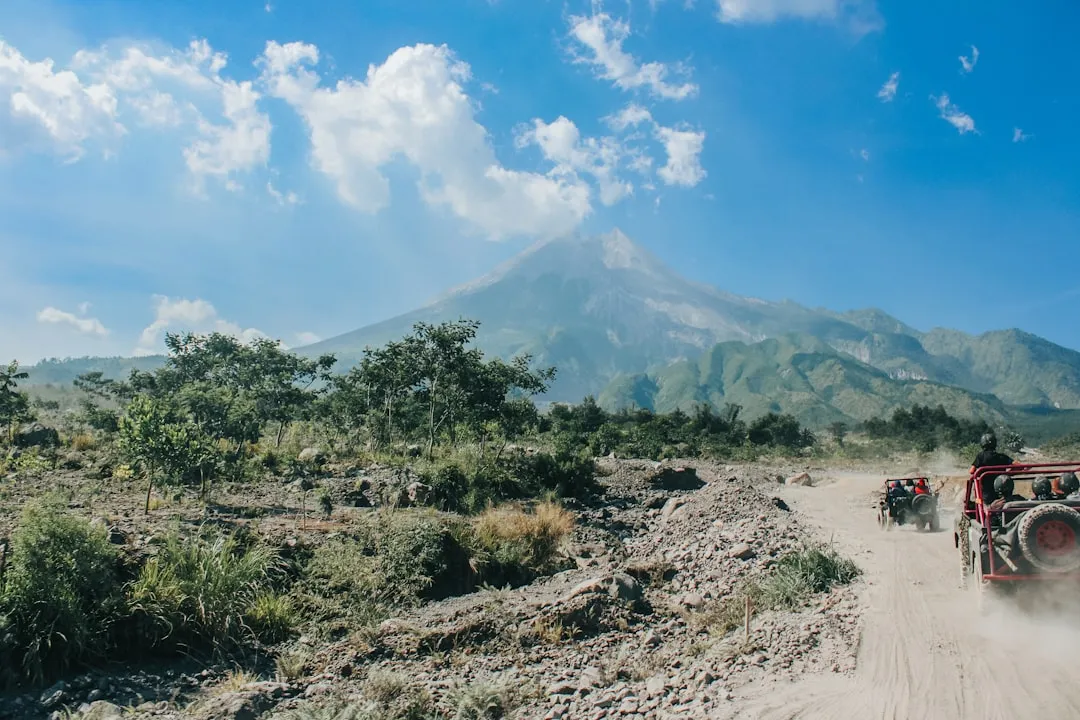
Mount Rinjani, or Gunung Rinjani, is an active stratovolcano that dominates the landscape of Lombok, Indonesia. Rising to a staggering 3,726 metres, it is the second-highest volcano in the country and a site of profound spiritual significance for both the local Sasak people and Balinese Hindus. The trek to the Crater Rim (Plawangan) is one of Southeast Asia's most iconic mountaineering challenges, offering a journey through diverse ecological zones—from lush tropical rainforests teeming with macaques to high-altitude savannahs and, finally, the stark, dramatic volcanic rock of the caldera edge. Standing on the rim, trekkers are rewarded with a panoramic view that is arguably unparalleled in the region: the turquoise waters of Lake Segara Anak (Child of the Sea) nestled within the caldera, the active sub-cone of Gunung Baru Jari smoking in the centre, and the distant silhouette of Bali’s Mount Agung shimmering on the horizon across the Lombok Strait.
- Distance: 20.0 km return (Senaru route)
- Duration: 2–3 days
- Season: April to December (Dry season; the park is typically closed from January to March)
- Accommodation: Tented campsites at designated rim locations (Plawangan Senaru or Plawangan Sembalun)
- Highest point: Senaru Crater Rim (2,641 m) or Sembalun Crater Rim (2,639 m)
- Difficulty: Challenging (requires high physical fitness and mental resilience)
- Access: Mandatory guide and porter services for most international trekkers
Overview
The Mount Rinjani Crater Rim trek is a masterclass in vertical geography. Unlike many alpine treks that offer gradual gradients, Rinjani is a relentless ascent that tests the limits of endurance. The journey typically begins at either the Senaru trailhead (600 m) or the Sembalun trailhead (1,100 m). The Senaru route, often preferred for those focusing specifically on the Crater Rim, takes trekkers through a dense, humid canopy of primary rainforest. This section of the trail is a sensory immersion into the tropics, where the air is thick with the scent of damp earth and the calls of the black ebony leaf monkey. As the elevation increases, the jungle thins, giving way to montane forests and eventually the open, windswept grasslands of the upper slopes.
The physical challenge is significant. Trekkers must navigate a 2,000-metre elevation gain over a relatively short horizontal distance, often involving steep, root-entwined paths and loose volcanic scree. However, the reward for this exertion is a landscape of cosmic proportions. The Rinjani caldera is a massive 6 km by 8.5 km oval, created by cataclysmic eruptions that have reshaped the island over millennia. The sight of the sun setting over the caldera, casting long shadows across the emerald lake and the smoking cone of Baru Jari, is a transformative experience. It is a place where the raw power of the Earth is visible and palpable, a stark reminder of the geological forces that continue to shape the Indonesian archipelago.
Beyond the physical and geological, the trek is a cultural odyssey. You will walk alongside local porters who carry immense loads—often up to 30 kg—using traditional bamboo poles balanced across their shoulders. Their agility and strength are legendary, and their presence is an integral part of the Rinjani experience. They are the guardians of the mountain, possessing an intimate knowledge of its moods and spirits. For the Sasak people, Rinjani is the "Seat of the Gods," and the trek is as much a pilgrimage as it is a recreational pursuit. This blend of extreme physical challenge, breathtaking natural beauty, and deep cultural resonance makes the Rinjani Crater Rim one of the most sought-after trekking destinations in the world.
History and Cultural Context
The geological history of Mount Rinjani is defined by one of the most significant volcanic events in human history. In 1257, the Samalas volcano (the precursor to the modern Rinjani complex) erupted with such violence that it is believed to have triggered a "Little Ice Age" across the Northern Hemisphere. The eruption was several times larger than the famous 1883 eruption of Krakatoa, ejecting massive amounts of tephra into the stratosphere and leaving behind the enormous caldera that trekkers visit today. This event fundamentally altered the topography of Lombok and left a lasting mark on the global climate record, found in ice cores from Greenland to Antarctica.
Culturally, Mount Rinjani is the spiritual anchor of Lombok. For the Sasak people, the mountain is a sacred site where the spirits of ancestors reside. Every year, thousands of pilgrims make the journey to the crater lake, Segara Anak, to perform the "Mulang Pakelem" ceremony. This ritual involves the offering of gold and other valuables to the lake to ensure harmony between the human and spirit worlds and to pray for rain and fertility for the island's crops. The lake's name, meaning "Child of the Sea," reflects the belief that the lake is a miniature version of the ocean, and its waters are considered to have healing properties.
The Balinese Hindus also hold Rinjani in high esteem, regarding it as one of the three most sacred mountains in the region, alongside Mount Agung in Bali and Mount Semeru in Java. The mountain is often depicted in local art and folklore as a place of refuge and enlightenment. During the colonial era, Dutch explorers and scientists began documenting the mountain's unique flora and fauna, but it wasn't until the late 20th century that Rinjani became a destination for international adventure tourism. Today, the Rinjani National Park (Taman Nasional Gunung Rinjani) manages the area, balancing the needs of conservation, spiritual practice, and the growing trekking industry.
Want more background? Read extended notes on history and cultural context → Learn more
Seasonal Highlights and Weather Reality
The trekking season on Mount Rinjani is strictly dictated by the Indonesian monsoon cycle. The park is generally open from early April to late December, coinciding with the dry season. During this window, the weather is most predictable, though "dry" is a relative term in the tropics. Even in the peak of summer, afternoon rain showers are common on the lower slopes, and the summit area can be shrouded in mist.
April to June: This is the "green season." Following the heavy rains of the monsoon, the landscape is incredibly lush. The waterfalls are at their most powerful, and the air is crisp and clear. This is an excellent time for photography, as the vegetation is vibrant and the dust levels are low. However, the trails can be slippery and muddy, requiring careful footwork.
July to September: This is the peak trekking season. The weather is at its driest, and the views are most consistent. However, this is also when the mountain is most crowded. The trails can become dusty, and the campsites at the rim can be busy. Temperatures at the Crater Rim during these months can drop significantly at night, often reaching 5°C or lower, despite the tropical heat at the base.
October to December: The transition back to the wet season begins. While trekking is still possible, the likelihood of heavy afternoon downpours increases. The mountain becomes quieter as the crowds thin out, offering a more solitary experience for those willing to brave the potential for wet gear. By late December, the park authorities usually close the trails due to the high risk of landslides and dangerous weather conditions.
January to March: The park is officially closed. During the height of the monsoon, the steep volcanic slopes become unstable, and the heavy rains make the river crossings and narrow ridge paths life-threatening. Attempting to trek during this time is illegal and extremely dangerous.
Recommended Itinerary
2-Day Senaru Crater Rim Itinerary
Day 1: Senaru Village to Senaru Crater Rim
- Distance: 10 km
- Elevation gain: 2,041 m
- Time: 6–8 hours
- Start at Senaru Trekking Centre (600 m) after registration at the Rinjani National Park office
- Initial 2 hours through thick tropical rainforest (Pos 1 to Pos 2)
- Lunch break at Pos 2 (Montong Satas, 1,500 m) – keep an eye out for grey macaques
- Continue ascent through montane forest to Pos 3 (Mondokan Lolak, 2,000 m)
- The final push involves a steep climb out of the forest line into the open savannah
- Arrive at Senaru Crater Rim (Plawangan Senaru, 2,641 m) in time for sunset
- Set up camp with views of the caldera, the lake, and Mount Agung in the distance
- Dinner prepared by porters under the stars
Day 2: Senaru Crater Rim to Senaru Village
- Distance: 10 km
- Elevation: 2,041 m descent
- Time: 5–6 hours
- Wake up at 5:30 AM for a spectacular sunrise over the caldera
- Breakfast at the rim while watching the light change over Lake Segara Anak
- Begin the long descent back through the same route
- The descent is taxing on the knees; trekking poles are highly recommended
- Stop at Pos 2 for a final mountain lunch
- Arrive back in Senaru Village by mid-afternoon
- Transfer to your next destination (Senggigi, Mataram, or the Gili Islands)
Important Notes:
- This itinerary focuses on the Senaru Rim. A 3-day itinerary is required to descend into the crater to the lake and hot springs.
- The Sembalun route is an alternative that starts higher (1,100 m) but involves more exposure to the sun in the early stages.
- All trekking must be organised through a licensed trekking agency.
- Porters carry all camping equipment and food; you only carry a daypack.
- Water is sourced from springs and boiled or filtered by the crew.
Planning and Bookings
Book Your Trip
Everything you need to plan your journey
Accommodation
Find places to stay near Mataram
Flights
Search flights to Mataram
Essential Preparation
Trekking Mount Rinjani is a serious undertaking that requires significant physical preparation. The 2,000-metre ascent on Day 1 is equivalent to climbing the stairs of the Burj Khalifa nearly three times in a single day, often on uneven and steep terrain. Cardiovascular training, such as hiking with a weighted pack, stair climbing, or long-distance running, should begin at least two months before your trip. Mental resilience is equally important, as the heat, humidity, and steep gradients can be demoralising.
Logistically, most trekkers base themselves in the villages of Senaru or Sembalun the night before the trek. Senaru is the more developed hub, offering a range of guesthouses and small hotels, as well as access to the spectacular Sindang Gila and Tiu Kelep waterfalls. It is essential to coordinate your booking with a reputable trekking company. These agencies handle the mandatory national park permits, guide and porter assignments, and transport from Lombok International Airport or the ferry ports. Booking in advance is highly recommended, especially during the peak months of July and August.
Trail Accommodation
Accommodation on the Mount Rinjani Crater Rim trek is exclusively in the form of tented campsites. There are no permanent huts or lodges on the mountain itself. Your trekking agency will provide all the necessary camping gear.
Campsite Facilities:
- Tents: Usually 2-person dome tents with waterproof flies.
- Sleeping Mats: Thin foam mats are standard; some premium operators provide thicker inflatable mats.
- Sleeping Bags: Rated for temperatures between 0°C and 10°C.
- Toilet Tents: A small privacy tent over a dug-out hole (standard practice on Rinjani).
- Dining: Meals are served on a ground sheet or a small folding table outside the tents.
- Water: Collected from mountain springs by porters and boiled for safety.
What is NOT Provided:
- Permanent toilets or showers (all washing is done with wet wipes or at the hot springs if on a 3-day trek).
- Electricity or charging stations (bring power banks).
- Pillows (bring an inflatable one or use clothes).
- Privacy: Campsites can be crowded and noisy during peak season.
Booking and Costs:
- Trekking packages typically range from US$150 to US$350 depending on the duration and level of service.
- This cost usually includes permits, guides, porters, food, water, and transport.
- A portion of the fee goes toward the Rinjani National Park entry permit (approx. IDR 150,000 per day for foreigners).
Required Gear
- Trekking boots: Must have deep lugs for grip on loose volcanic scree and provide good ankle support.
- Daypack: 25–35 litres with a rain cover. You only carry your personal items; porters carry the rest.
- Head torch: Essential for the early morning sunrise start and navigating the campsite at night.
- Trekking poles: Highly recommended for the 2,000-metre descent to protect your knees.
- Waterproof jacket: A lightweight, breathable shell for afternoon rain and wind protection on the rim.
- Insulating layer: A down jacket or heavy fleece. Temperatures at the rim drop significantly after sunset.
- Base layers: Moisture-wicking synthetic or merino wool fabrics. Avoid cotton, which stays wet and cold.
- Personal First Aid Kit: Include blister pads (Compeed), rehydration salts, ibuprofen, and any personal medications.
What to Bring
- Sun protection: High SPF sunscreen, lip balm with SPF, sunglasses, and a wide-brimmed hat. The tropical sun is intense at high altitudes.
- Toiletries: Biodegradable wet wipes (your "mountain shower"), hand sanitiser, toothbrush, and toothpaste.
- Power bank: To keep your phone and camera charged for the thousands of photos you will take.
- Snacks: While meals are provided, personal energy bars, trail mix, or chocolate can provide a much-needed morale boost.
- Water treatment: While guides boil water, bringing a LifeStraw or purification tablets provides an extra layer of security.
- Cash: Small denominations of Indonesian Rupiah (IDR) for tipping guides and porters (standard practice) and for buying cold drinks at the trailheads.
- Sandals or flip-flops: To wear around the campsite to give your feet a break from boots.
- Earplugs: Campsites can be noisy with the sounds of other trekking groups and the wind.
Permits
Access to Mount Rinjani is strictly regulated by the Rinjani National Park Authority (TNGR). All trekkers are required to have a valid permit, which is now managed through an online booking system called "e-Rinjani." This system was implemented to control the number of visitors on the mountain and to ensure that all trekkers are registered for safety and conservation purposes.
Booking Process:
- Most trekkers do not book the permit themselves; instead, the trekking agency includes the permit as part of their package.
- The agency will require a copy of your passport to complete the registration.
- There is a daily quota for each trailhead (Senaru and Sembalun). During peak season, these quotas can fill up weeks in advance.
- Upon arrival at the trailhead, you must present your permit and passport at the National Park office for a mandatory briefing and medical check (often a simple self-declaration or a quick blood pressure check).
Permit Costs:
- For international visitors, the permit fee is approximately IDR 150,000 per person, per day.
- For Indonesian citizens, the fee is significantly lower (approx. IDR 5,000–10,000 per day).
- These fees contribute to the maintenance of the park, though waste management remains a challenge that requires additional funding and volunteer effort.
Guide and Porter Requirements:
- It is mandatory for all international trekkers to be accompanied by a licensed guide.
- Porters are not strictly mandatory by law but are practically essential for carrying the heavy camping gear and water required for the trek.
- Using local guides and porters is a vital part of the local economy in Senaru and Sembalun, providing livelihoods for hundreds of families.
Other Activities in the Area
Lombok offers a wealth of experiences beyond the slopes of Rinjani. Consider these activities to round out your trip:
- Sindang Gila and Tiu Kelep Waterfalls: Located in Senaru, these are two of the most beautiful waterfalls in Indonesia. Tiu Kelep, in particular, requires a short trek through the jungle and a river crossing, rewarding you with a massive curtain of water falling into a swimmable pool.
- The Gili Islands: After the dust and exertion of Rinjani, the three Gili Islands (Trawangan, Meno, and Air) offer the perfect tropical recovery. No motorised vehicles are allowed, and the snorkelling with sea turtles is world-class.
- Kuta Lombok: Located on the south coast, this area is famous for its rugged coastline, white sand beaches (like Tanjung Aan), and world-class surfing breaks. It is much quieter and more laid-back than its namesake in Bali.
- Sasak Cultural Villages: Visit villages like Sade or Ende to learn about the traditional architecture, weaving (Ikat), and customs of the Sasak people.
- Tetebatu: Often called the "Ubud of Lombok," this area on the southern slopes of Rinjani offers beautiful rice terrace walks, monkey forests, and a cooler climate.
Safety and Conditions
Volcanic Activity: Mount Rinjani is an active volcano. The sub-cone, Baru Jari, erupted as recently as 2016. The National Park Authority monitors volcanic activity closely in conjunction with the Indonesian Centre for Volcanology and Geological Hazard Mitigation (PVMBG). Always check the current alert level before starting your trek. If the volcano shows signs of increased activity, the park will be closed immediately.
Altitude Sickness: While the Crater Rim is at 2,641 m, altitude sickness (Acute Mountain Sickness) can still affect some trekkers, especially given the rapid ascent from sea level. Symptoms include headache, nausea, and dizziness. The best prevention is to stay hydrated, climb at a steady pace, and inform your guide immediately if you feel unwell. The only cure for worsening AMS is descent.
Terrain and Weather: The trails on Rinjani are steep and can be dangerous. The 2018 earthquakes caused significant landslides, and while the main trails have been cleared and rerouted, some sections remain narrow with steep drop-offs. Heavy rain can make the volcanic soil extremely slippery. Always follow your guide's instructions and stay on the marked paths.
Dehydration and Heat: The combination of tropical humidity and intense physical exertion makes dehydration a real risk. Drink at least 3–4 litres of water per day. Your porters will provide water, but it is your responsibility to drink it. Electrolyte powders are a valuable addition to your kit.
Hypothermia: It is a common mistake to assume that because Lombok is tropical, the mountain will be warm. At 2,600 m, the temperature can drop to near freezing, especially with wind chill on the rim. Ensure you have adequate warm layers and a dry set of clothes to change into once you reach camp.
Side Trips and Points of Interest
Segara Anak Lake: For those on a 3-day or 4-day itinerary, the descent into the caldera to the shores of Segara Anak is the highlight. The lake is 230 metres deep and filled with fish (mostly tilapia and carp), which the porters often catch for dinner. The reflection of the crater walls in the still morning water is a sight of profound peace.
Aik Kalak Hot Springs: Located just a short walk from the lake campsite, these natural thermal springs are believed to have medicinal properties. Soaking your sore muscles in the warm, mineral-rich water while looking up at the towering crater walls is one of the great rewards of the longer Rinjani treks.
Gunung Baru Jari: While you cannot climb the active sub-cone itself, the 3-day trek takes you close to its base. Seeing the "New Mountain" (which emerged within the caldera of the old one) is a vivid lesson in geology and the ongoing birth of the Indonesian islands.
The "7 Hills of Regret": On the Sembalun route, the final approach to the rim involves a series of seven steep hills. They are named for the mental toll they take on trekkers who think they are "almost there" only to see another ridge appearing. Conquering these hills is a rite of passage for Rinjani trekkers.
Leave No Trace
Mount Rinjani faces a significant waste management crisis. The popularity of the trek has led to an accumulation of plastic waste and food scraps at the campsites. As a visitor, you have a moral and environmental responsibility to minimise your impact on this sacred landscape.
Leave No Trace Principles on Rinjani:
- Pack it in, pack it out: Ensure that your trekking agency has a clear waste management policy. All plastic bottles, tins, and wrappers brought up by your group must be carried back down.
- Dispose of waste properly: Use the toilet tents provided by your agency. Do not leave "white flowers" (toilet paper) on the trail or around the campsite.
- Respect wildlife: Do not feed the macaques or silver leaf monkeys. Feeding them alters their natural behaviour and can make them aggressive toward trekkers.
- Stay on the trail: To prevent further erosion on the steep volcanic slopes, avoid taking shortcuts between switchbacks.
- Minimise campfire impact: Wood is scarce at high altitudes. Most agencies use gas stoves for cooking; do not encourage or start wood fires on the rim.
- Be considerate of others: Rinjani is a spiritual place. Keep noise levels down at the campsite so everyone can enjoy the silence of the mountains.