Mount Norikura Summit - Japan's Majestic Peak
Mount Norikura, standing at 3,026 metres, is one of Japan's most accessible and popular mountains, offering a rewarding day hike with breathtaking alpine scenery. Located on the border of Nagano and Gifu prefectures, it is part of the Chubu Sangaku National Park, also known as the Northern Japan Alps. The summit is reachable via a scenic drive along the Norikura Skyline, one of Japan's highest asphalt roads, which terminates at the Tatami-daira (2,700 m), the trailhead for the final ascent. This unique access makes Norikura a fantastic option for those seeking high-altitude mountain experiences without the need for multi-day expeditions or extensive mountaineering expertise. The trail winds through alpine meadows, past volcanic landscapes, and culminates in panoramic views that stretch across the Japanese Alps on clear days. It's a journey into a starkly beautiful, high-altitude environment that changes dramatically with the seasons, offering a vibrant display of alpine flora in summer and a snow-covered wonderland in winter.
- Distance: 7.5 km (round trip from Tatami-daira)
- Elevation Gain: 700 m (from Tatami-daira to summit)
- Duration: 4–6 hours (round trip)
- Season: July to October (main hiking season); snow can persist into early July and start in September.
- Huts: No overnight accommodation on the summit trail; day hike only.
- Highest point: Kengamine (3,026 m)
- Difficulty: Moderate (due to altitude and steep sections)
- Access: Via Norikura Skyline bus from Norikura Kogen Tourist centre.
Overview
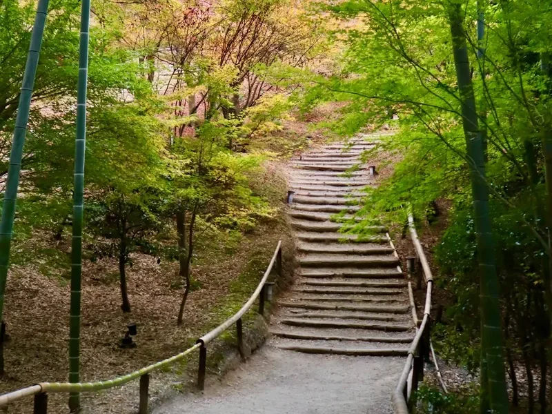
Mount Norikura's appeal lies in its accessibility and the dramatic, almost otherworldly landscape it presents. The journey begins at Tatami-daira, a vast, flat plateau that feels like stepping onto another planet. From here, the trail to Kengamine, Norikura's highest peak, is a well-trodden path that ascends through a rugged, volcanic terrain. The route is characterised by steep, rocky sections and a significant elevation gain over a relatively short distance, demanding a good level of fitness. However, the path is generally clear and well-maintained, with occasional stone steps and handrails in steeper areas.
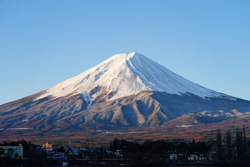
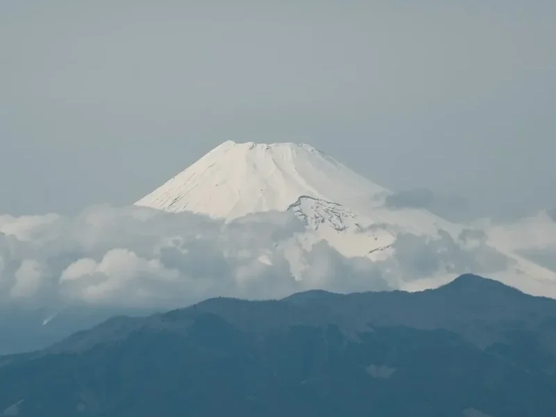
As you climb, the vegetation thins, giving way to alpine scree and rock fields. The air becomes noticeably thinner, and the temperature drops, even in summer. The views that unfold with every metre gained are spectacular. On a clear day, the panorama from the summit is unparalleled, encompassing a vast swathe of the Japanese Alps, including prominent peaks like Mount Hotaka, Mount Yari, and Mount Fuji in the far distance. The summit area itself is a cluster of rocky outcrops, with Kengamine being the highest point, marked by a small shrine and a weather station. The descent offers a different perspective on the landscape, often revealing hidden valleys and unique rock formations.
The mountain is a dormant volcano, and its geological history is evident in the surrounding terrain. The presence of numerous smaller peaks and craters around the main summit adds to the complex and fascinating topography. Norikura is particularly popular during the summer months when the alpine flowers are in bloom, transforming the slopes into a colourful carpet. However, even outside the peak season, the stark beauty of the volcanic landscape and the challenging ascent make it a compelling destination for hikers and nature enthusiasts.
History and Cultural Context
Mount Norikura has a long history of human interaction, primarily as a sacred mountain and a site for religious pilgrimage. For centuries, it has been revered as a dwelling place of deities, and its volcanic nature has contributed to its mystical aura. Shinto beliefs often associate mountains with powerful spirits, and Norikura was no exception. Pilgrims would undertake arduous journeys to its summit, seeking spiritual purification and divine blessings.
The development of the Norikura Skyline road in the mid-20th century significantly changed access to the mountain. This engineering feat, one of the highest roads in Japan, opened up the higher altitudes to a much wider audience, transforming Norikura from a challenging pilgrimage site into a popular tourist destination and hiking spot. The road's construction was a major undertaking, involving extensive tunnelling and bridge building to navigate the steep mountain terrain. Its completion in 1970 marked a new era for Norikura, allowing visitors to reach Tatami-daira with relative ease.
Despite its modern accessibility, the mountain retains its spiritual significance. Small shrines and religious markers can still be found along the trails and at the summit, testament to its enduring cultural importance. The area is also part of the Chubu Sangaku National Park, established in 1934, which protects its unique natural environment, including its alpine flora, fauna, and geological features. The park's designation underscores the national recognition of Norikura's ecological and aesthetic value.
Seasonal Highlights and Weather Reality
Mount Norikura's character changes dramatically throughout its relatively short hiking season, which typically runs from July to October. Each period offers a distinct experience, influenced by weather, flora, and snow conditions.
July: Alpine Bloom and Lingering Snow
Early July can still see significant snow patches, particularly on the northern slopes and in shaded gullies. However, this is also when the alpine meadows begin to burst into life. Flowers like the Japanese alpine rose (Rhododendron japonicum), gentians, and various saxifrages create vibrant displays. The weather can be unpredictable, with afternoon thunderstorms being common. The higher sections of the trail may still be partially covered in snow, requiring careful footing and potentially the use of microspikes.
August: Peak Summer and Vibrant Flora
August is generally considered the prime month for hiking Norikura. The snow has usually melted from the main trails, and the alpine flora is at its most abundant. The meadows are a riot of colour, attracting photographers and nature lovers. The weather is typically more stable, though still prone to afternoon showers. The higher altitude means temperatures are cool, even on sunny days, so warm layers are essential. This is also the busiest month, with weekends often crowded.
September: Autumn Colours and Crisp Air
As summer transitions to autumn, Norikura offers a different kind of beauty. The alpine grasses and low-lying shrubs begin to turn golden and red, creating a striking contrast with the dark volcanic rock. The air becomes crisp and clear, offering excellent visibility for panoramic views. While the flowers are past their peak, the autumn colours provide a spectacular visual experience. The risk of early snowfall increases towards the end of the month, so checking forecasts is crucial.
October: Early Winter and Snowfall
October marks the end of the main hiking season. Snowfall becomes more frequent, and by mid-to-late October, the summit area is often covered in a significant layer of snow. While experienced mountaineers with appropriate gear might still attempt the climb, it is generally considered too hazardous for casual hikers. The Norikura Skyline road itself may close due to snow, further limiting access. For those seeking a winter wonderland experience, early snow can offer beautiful, albeit challenging, conditions.
Weather Reality:
Regardless of the season, mountain weather is notoriously fickle. Norikura is exposed to strong winds, and temperatures can drop rapidly. Even on a sunny summer day, the summit can feel very cold, especially with wind chill. Hypothermia is a real risk. Always be prepared for rain, fog, and sudden temperature drops. Checking the weather forecast from reliable sources like MetService or the Japan Meteorological Agency is paramount before and during your hike.
Recommended Itinerary
Mount Norikura Summit Day Hike Itinerary
Early Morning (Approx. 7:00 AM - 8:00 AM): Travel to Norikura Kogen
- Depart from Takayama Nohi Bus Terminal.
- Take the direct bus to Norikura Kogen Tourist centre Bus Terminal.
- Journey time is approximately 1.5 hours.
- Enjoy the scenic drive as you approach the mountains.
Morning (Approx. 8:00 AM - 9:30 AM): Bus to Tatami-daira
- Transfer to the bus bound for Tatami-daira (the highest point accessible by public transport in Japan).
- The bus route follows the Norikura Skyline, offering spectacular views as you ascend.
- The ride takes approximately 50 minutes to 1 hour.
- Arrive at Tatami-daira (2,700 m).
Late Morning (Approx. 9:30 AM - 10:30 AM): Acclimatisation and Preparation at Tatami-daira
- Spend time acclimatising to the altitude. Tatami-daira is a large, relatively flat area with visitor facilities.
- Use the restrooms, and take a moment to adjust to the thinner air.
- Organise your daypack: ensure you have water, snacks, rain gear, and warm layers.
- Note the starting point of the trail towards the summit.
Midday (Approx. 10:30 AM - 1:00 PM): Ascent to Kengamine Summit
- Begin the hike from Tatami-daira towards Kengamine (3,026 m).
- The trail is well-marked but can be steep and rocky in sections.
- Pass by the volcanic crater lake, Goshiki-ga-hara ("Five-Coloured Plains"), which may be frozen or partially frozen depending on the season.
- Continue ascending through scree and rock fields.
- Take short breaks as needed to catch your breath and hydrate.
- Enjoy the increasingly expansive views of the surrounding Japanese Alps.
Early Afternoon (Approx. 1:00 PM - 2:00 PM): Summit Experience at Kengamine
- Reach Kengamine, the highest peak of Mount Norikura.
- Take in the 360-degree panoramic views. On a clear day, you can see Mount Fuji, Mount Hotaka, and many other iconic peaks.
- Visit the small shrine and weather station at the summit.
- Enjoy a packed lunch or snacks while appreciating the incredible vista.
- Be mindful of the time and the weather; conditions can change rapidly at this altitude.
Afternoon (Approx. 2:00 PM - 4:00 PM): Descent to Tatami-daira
- Begin your descent back to Tatami-daira.
- The descent can be faster but requires careful footing on loose scree.
- Take advantage of the different perspectives on the landscape during the descent.
- Continue to acclimatise to the lower altitude as you descend.
Late Afternoon (Approx. 4:00 PM - 5:30 PM): Return Journey
- Catch the bus from Tatami-daira back down to Norikura Kogen Tourist centre.
- Transfer to the bus heading back to Takayama.
- Reflect on your successful summit of Mount Norikura.
Important Notes:
- This is a strenuous day hike due to altitude and elevation gain.
- Start early to allow ample time and avoid afternoon thunderstorms.
- Always check the weather forecast before and during your hike.
- Carry sufficient water and high-energy snacks.
- Wear sturdy hiking boots and dress in layers.
- Be prepared for cold temperatures and strong winds at the summit.
- Mobile phone signal can be intermittent or non-existent at higher elevations.
Planning and Bookings
Book Your Trip
Everything you need to plan your journey
Accommodation
Find places to stay near Takayama
Flights
Search flights to Takayama
Essential Preparation
Mount Norikura is a popular destination, and planning is key to a successful and enjoyable visit. The primary logistical challenge is reaching the trailhead at Tatami-daira. The most common starting point for accessing Norikura is Takayama, a historic city in Gifu Prefecture. From Takayama, you will need to take a bus to the Norikura Kogen Tourist centre, and then transfer to a bus that ascends the Norikura Skyline to Tatami-daira.
Fitness: The hike to the summit involves a significant elevation gain of approximately 700 metres over a distance of about 3.75 km one way. Combined with the high altitude (starting at 2,700 m and reaching 3,026 m), this requires a good level of cardiovascular fitness and stamina. It is advisable to spend a day or two in Takayama or at a lower altitude to acclimatise before attempting the summit hike, especially if you are coming from sea level.
Logistics: Ensure you check the bus schedules in advance, as they can vary by season and day of the week. Buses to Tatami-daira typically operate from late April/early May to late October/early November, weather permitting. Limited parking is available at Norikura Kogen, but it is recommended to use public transport from Takayama. The Norikura Skyline road is a toll road, and bus fares include this fee.
Base Town: Takayama is an excellent base town. It offers a range of accommodation from traditional ryokans to modern hotels and hostels. It also has a well-developed tourist infrastructure, including restaurants, shops, and information centres. Takayama is easily accessible by train from major cities like Nagoya and Toyama.
Trail Accommodation
This is a day hike requiring no overnight accommodation on the trail itself. All hiking is completed within a single day, starting and finishing at Tatami-daira. Visitors typically stay in accommodation in Takayama or the surrounding Norikura Kogen area before and after their hike.
Required Gear
- Hiking Boots: Sturdy, waterproof hiking boots with good ankle support are essential. Ensure they are well broken-in to prevent blisters.
- Waterproof Jacket: A high-quality waterproof and windproof jacket is crucial. Mountain weather can change rapidly, and rain and strong winds are common.
- Waterproof Overtrousers: Essential for protection against rain and wind, especially at higher altitudes.
- Warm Layers: Even in summer, temperatures at 3,000 metres can be cold. Bring a fleece or down jacket, thermal base layers (merino wool or synthetic), and a warm hat (beanie) and gloves.
- Backpack: A comfortable daypack (20-30 litres) to carry essentials like water, food, extra clothing, and safety gear. A rain cover for the backpack is recommended.
- Navigation: While the main trail to Kengamine is well-marked, a map of the area and a compass or GPS device are advisable, especially if you plan to explore any side routes or if visibility is poor. A charged mobile phone with offline maps downloaded is also useful.
- Safety Gear: A basic first-aid kit including blister treatment, pain relievers, antiseptic wipes, and any personal medications. A head torch with spare batteries is recommended in case of unexpected delays.
What to Bring
- Food: Pack plenty of high-energy snacks and a substantial lunch. Options for purchasing food at Tatami-daira are limited and can be expensive. Consider bringing items like energy bars, nuts, dried fruit, sandwiches, and chocolate.
- Water: Carry at least 1.5 to 2 litres of water per person. There are no reliable water sources on the trail itself, and water treatment is not recommended due to the volcanic nature of the terrain.
- Sun Protection: High-altitude sun is intense. Bring high SPF sunscreen, sunglasses, and a wide-brimmed hat or cap.
- Toiletries: Small personal items like hand sanitiser, lip balm, and any personal hygiene products. Toilet paper is available at Tatami-daira facilities.
- Camera: To capture the stunning alpine scenery. Ensure batteries are fully charged.
- Cash: For bus fares, any small purchases at Tatami-daira, or emergency needs. Credit card facilities may be limited.
- Trekking Poles: Optional but highly recommended, especially for the descent, as they can reduce strain on your knees and provide extra stability on rocky terrain.
Permits
No specific permits are required to hike Mount Norikura's summit trail from Tatami-daira. The area is part of the Chubu Sangaku National Park, and access to the trails is generally free. However, there is a toll for using the Norikura Skyline road, which is included in the bus fare from Norikura Kogen.
Bus Fares:
- The bus service from Norikura Kogen Tourist centre to Tatami-daira is operated by Alpico Kotsu.
- Fares are subject to change but typically range from approximately ¥2,000 to ¥2,500 one way for adults. Round-trip tickets are often available at a slightly reduced price.
- It is advisable to check the latest fare information on the Alpico Kotsu website or at the bus terminal in Takayama.
National Park Regulations: While no specific hiking permits are needed, visitors are expected to adhere to the regulations of Chubu Sangaku National Park. This includes respecting the natural environment, staying on marked trails, not disturbing wildlife, and packing out all rubbish.
Seasonal Access: Access to Tatami-daira via the Norikura Skyline road is seasonal. The road typically opens in late April or early May and closes in late October or early November, depending on snow conditions. Outside these months, the road is impassable to regular vehicles and buses.
Other Activities in the Area
Beyond the summit hike, the Mount Norikura area offers several other attractions and activities:
- Exploring Tatami-daira: The plateau itself is a beautiful alpine environment. Take time to walk around the visitor centre area, admire the alpine flowers in season, and enjoy the expansive views without undertaking the full summit climb.
- Short Walks from Tatami-daira: Several shorter, less strenuous walks are available from Tatami-daira. These include paths around the plateau and to viewpoints overlooking the surrounding valleys.
- Norikura Kogen: The "highlands" below the summit offer a different landscape with waterfalls, forests, and hot springs. The Norikura Kogen area is a popular destination for cycling and enjoying nature walks.
- Mount Ontake: While a more challenging and serious undertaking, Mount Ontake (3,067 m) is another significant volcano in the region, accessible from the Kiso Valley side. It is a sacred mountain with a strong spiritual following.
- Kamikochi: A stunning alpine valley and resort area in the Northern Japan Alps, accessible from Matsumoto. It offers beautiful river scenery, hiking trails, and is a gateway to more challenging alpine routes.
- Takayama City: Explore the historic Sanmachi Suji district with its preserved Edo-period streets, visit the morning markets, and enjoy local cuisine.
- Hida Folk Village (Hida no Sato): An open-air museum showcasing traditional thatched-roof houses from the Hida region.
Safety and Conditions
Altitude Sickness: Mount Norikura's summit is over 3,000 metres, making altitude sickness a significant concern. Symptoms can include headache, nausea, dizziness, and fatigue. The best prevention is to ascend gradually and allow time for acclimatisation. Spending a night at a lower altitude (e.g., Takayama or Norikura Kogen) before hiking is highly recommended. If symptoms appear, descend immediately.
Weather: Mountain weather is unpredictable. Be prepared for rapid changes, including strong winds, rain, fog, and even snow, especially at the summit, even in mid-summer. Always check the weather forecast from reliable sources (e.g., Japan Meteorological Agency, MetService for backcountry forecasts) before you go and be prepared to turn back if conditions deteriorate.
Trail Conditions: The trail from Tatami-daira to Kengamine is generally well-maintained but can be steep, rocky, and slippery, particularly after rain or if snow patches remain. Wear appropriate footwear and use trekking poles for stability. In early season (July), snow can linger on shaded parts of the trail, requiring caution and potentially microspikes.
Volcanic Activity: Mount Norikura is a dormant volcano. While there is no immediate threat, be aware of the volcanic nature of the terrain. Information on volcanic activity can be obtained from local authorities or the Japan Meteorological Agency.
Wildlife: While large dangerous animals are not common on Norikura, be aware of smaller wildlife. Respect their space and do not feed them. The alpine environment is fragile.
Emergency Contacts: In case of an emergency, contact local police or mountain rescue services. Mobile phone reception can be unreliable at higher altitudes, so consider carrying a personal locator beacon (PLB) if venturing into more remote areas or if you are hiking alone. The bus drivers and staff at Tatami-daira can also provide assistance.
Travel Insurance: Ensure you have adequate travel insurance that covers hiking and potential medical evacuation.
Side Trips and Points of Interest
Kengamine Summit (3,026 m): The primary objective for most hikers. Reaching the highest point of Mount Norikura offers unparalleled 360-degree views of the Japanese Alps. The summit area is a collection of rocky peaks, with Kengamine being the highest, marked by a small shrine and a weather station. The sense of accomplishment and the breathtaking vistas make the challenging ascent worthwhile.
Goshiki-ga-hara ("Five-Coloured Plains"): Located on the route from Tatami-daira, this is a vast, relatively flat area dotted with small ponds and alpine vegetation. Depending on the season, the colours of the vegetation and the water can vary, giving it its name. It's a beautiful spot for a brief rest and to appreciate the unique alpine landscape.
Crater Lakes: Several small crater lakes are scattered around the summit area. These are remnants of the mountain's volcanic past. Some may be frozen for much of the hiking season, adding to the stark beauty of the landscape.
Mount Ebisu (2,700 m) and Mount Dainichi (2,767 m): These are two of the prominent peaks surrounding Tatami-daira. While not as high as Kengamine, they offer alternative hiking routes or can be incorporated into longer treks for experienced hikers. They provide different perspectives of the Norikura massif.
Norikura Skyline Views: The bus journey itself is a point of interest. The Norikura Skyline is one of Japan's highest roads, offering spectacular views of the surrounding mountains and valleys as you ascend. Pull-offs along the road provide opportunities to stop and admire the scenery.
Leave No Trace
Mount Norikura, as part of the Chubu Sangaku National Park, is a precious natural environment that requires careful stewardship. Adhering to Leave No Trace principles ensures that this beautiful mountain remains pristine for future generations of hikers and for the preservation of its unique alpine ecosystem.
Plan Ahead and Prepare: Research the trail, weather conditions, and bus schedules. Pack appropriate gear and sufficient food and water. Understand the altitude and its effects.
Travel and Camp on Durable Surfaces: Stick to marked trails. The alpine vegetation is fragile and slow to recover from damage. Avoid walking on moss or through delicate meadows. Tatami-daira is a developed area, and the summit trail is well-defined.
Dispose of Waste Properly: Pack out everything you pack in. This includes all food scraps, wrappers, and any other litter. There are no bins on the mountain; you must carry your rubbish back down to Takayama or your accommodation to dispose of it responsibly.
Leave What You Find: Do not take any natural souvenirs, such as rocks, plants, or flowers. Leave the mountain as you found it.
Minimise Campfire Impacts: This is a day hike, so campfires are not applicable. However, if you were to camp in designated areas (which are not on the summit trail), always use established fire rings and ensure fires are completely extinguished.
Respect Wildlife: Observe wildlife from a distance. Do not feed any animals, as human food can be harmful to them and alter their natural behaviour. Keep a safe distance and avoid disturbing them.
Be Considerate of Other Visitors: Keep noise levels down, especially at Tatami-daira. Yield to uphill hikers. Be patient and courteous to fellow visitors sharing the trail and the summit.