
Mount Myoko Trail - A Challenging Ascent in Japan's Alps
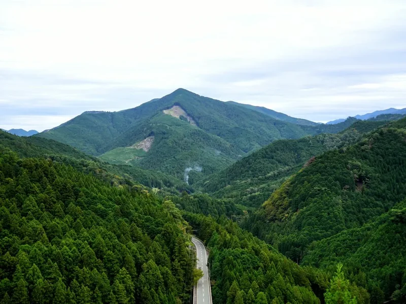
The Mount Myoko Trail is a demanding yet incredibly rewarding mountain track located in the heart of Japan's Northern Alps. This challenging ascent takes hikers through diverse landscapes, from dense forests to alpine meadows and rocky ridges, culminating in breathtaking panoramic views from the summit of Mount Myoko. It is a journey that tests physical endurance and offers a profound connection with Japan's natural beauty, showcasing volcanic landscapes, ancient forests, and the stark grandeur of the alpine environment. The trail is best experienced during the warmer months when snow has receded from the higher elevations, revealing a vibrant alpine flora and offering clear vistas of the surrounding peaks.
- Distance: 13.5 km one-way
- Elevation Gain: 1462 m
- Duration: 8-10 hours (round trip)
- Season: Late June to early November
- Difficulty: Challenging
- Closest City: Myoko
- Trailhead Access: Sasagamine (via Joetsu-Myoko Station)
- Permits: Not required, but registration recommended
Overview
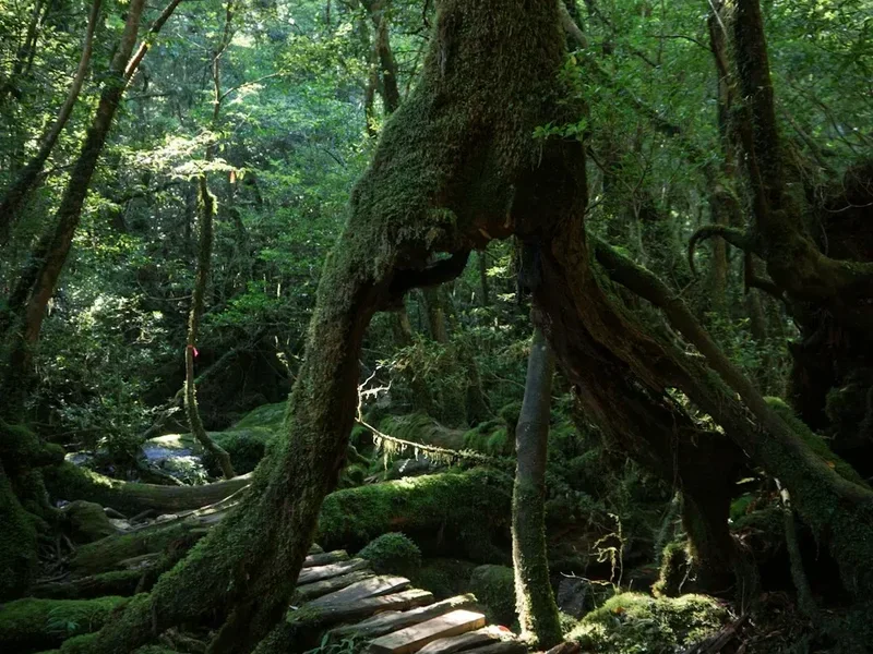
Mount Myoko, standing at 2,454 metres, is a stratovolcano and one of the most iconic peaks in the Niigata Prefecture. The trail to its summit is a classic alpine trek, characterised by a significant elevation gain over a relatively short distance. The journey begins in the verdant lower slopes, where ancient cedar and beech forests provide a cool, shaded environment. As hikers ascend, the vegetation gradually changes, transitioning into subalpine scrub and eventually into open alpine meadows dotted with wildflowers during the summer months. The final push to the summit involves navigating rocky scree slopes and exposed ridges, offering increasingly spectacular views with every metre gained.
The summit of Mount Myoko provides a truly awe-inspiring 360-degree panorama. On a clear day, hikers can see the Sea of Japan to the west, the vast expanse of the Northern Alps to the south, and the rolling hills of the Echigo Plain to the east. The volcanic nature of the mountain is evident in the surrounding landscape, with numerous smaller peaks and craters visible. The trail is well-maintained but steep, requiring a good level of fitness and appropriate gear. It is a popular destination for both local hikers and international visitors seeking a challenging day hike with a significant payoff in terms of scenery and accomplishment.
The trail is typically tackled as a strenuous day hike, with most people starting early in the morning to allow ample time for the ascent and descent, and to maximise their chances of good weather. While there are no official overnight accommodations directly on the trail, the nearby town of Myoko offers a range of options for pre- and post-hike stays, including traditional ryokans and modern hotels.
History and Cultural Context
Mount Myoko has long held spiritual significance for the local communities. As a prominent volcanic peak, it has been revered as a sacred mountain for centuries, with a history of religious pilgrimages and ascetic practices. Shugendo, a syncretic Japanese religion that combines elements of Buddhism, Shintoism, and Taoism, has a strong presence in the region, and Mount Myoko is considered a significant training ground for ascetics (yamabushi) who undertake arduous journeys to mountain summits.
The earliest records of ascents date back to the Edo period (1603-1868), when monks and devout individuals would climb the mountain to pray for good harvests, protection from natural disasters, and spiritual enlightenment. These early ascents were often undertaken during the summer months when the snow had melted, and the trails were passable. The routes were not as clearly defined as they are today, and the journeys were fraught with peril due to the challenging terrain and unpredictable weather.
In the Meiji era (1868-1912), with the opening of Japan to the West, mountaineering began to gain popularity as a recreational activity. Mount Myoko, with its accessible yet challenging nature, became a popular destination for both Japanese and foreign climbers. The development of infrastructure, including the establishment of mountain huts and improved trail markings, further facilitated access to the summit. Today, while the spiritual significance of Mount Myoko endures, it is also celebrated as a premier hiking destination, offering a glimpse into Japan's rich cultural heritage and its deep connection with the natural world.
Seasonal Highlights and Weather Reality
The Mount Myoko Trail is a seasonal hike, with the best window for ascent running from late June to early November. During this period, the weather is generally more stable, and the snow has melted from the higher elevations, making the trail accessible and safe.
Late June to July: This is the beginning of the alpine season. The snow is rapidly melting, revealing vibrant alpine meadows carpeted with wildflowers such as gentians, alpine roses, and lilies. The air is fresh, and the forests are lush and green. However, there can still be lingering snow patches at higher elevations, and the weather can be changeable, with afternoon thunderstorms being a common occurrence.
August to September: This is often considered the prime hiking season. The weather is typically at its most stable, with long, sunny days and clear skies. The alpine meadows are in full bloom, creating a spectacular display of colour. The summit views are usually at their most expansive and breathtaking. However, this is also the busiest period, so expect to encounter other hikers on the trail.
October to early November: As autumn progresses, the landscape transforms into a tapestry of vibrant colours. The deciduous forests at lower elevations turn brilliant shades of red, orange, and yellow, creating a stunning contrast with the evergreen conifers and the rocky alpine terrain. The air becomes crisp and cool, and the crowds begin to thin. However, the weather can become more unpredictable, with the possibility of early snowfalls and colder temperatures, especially at higher altitudes. It is crucial to check the weather forecast carefully before heading out during this period.
Winter (November to May): Mount Myoko is covered in deep snow during the winter months, making the trail impassable and extremely dangerous for unequipped hikers. The area is popular for winter sports such as skiing and snowboarding, but hiking is not recommended. The roads leading to the trailhead may also be closed due to heavy snowfall.
Weather Reality: It is crucial to understand that mountain weather is notoriously unpredictable. Even during the peak season, conditions can change rapidly. Be prepared for all types of weather, including strong winds, rain, fog, and sudden drops in temperature, even on a sunny day. Always check the latest weather forecast before you set out and be prepared to turn back if conditions deteriorate.
Recommended Itinerary
Mount Myoko Trail - Day Hike Itinerary
Early Morning (Approx. 5:00 AM - 6:00 AM): Departure from Myoko
- Depart from your accommodation in Myoko or the surrounding area.
- Travel by car or taxi to the Sasagamine trailhead. This journey typically takes around 1 hour.
- Ensure you have all your gear packed and ready.
Morning (Approx. 7:00 AM - 8:00 AM): Trailhead Arrival and Registration
- Arrive at the Sasagamine trailhead.
- Locate the visitor centre or registration point. It is highly recommended to register your hike here for safety purposes.
- Final gear check and preparation.
- Begin your ascent.
Morning to Midday (Approx. 8:00 AM - 12:00 PM): Forest Ascent
- The initial part of the trail winds through dense cedar and beech forests.
- The path is well-defined but can be steep in sections.
- Enjoy the cool, shaded environment and the sounds of the forest.
- Keep an eye out for the changing vegetation as you gain elevation.
- You will pass through areas with moss-covered trees and potentially small streams.
Midday (Approx. 12:00 PM - 2:00 PM): Alpine Meadows and Ridge Traverse
- The forest begins to thin, giving way to open alpine meadows.
- This section offers the first expansive views of the surrounding mountains.
- If hiking in summer, expect to see a variety of alpine wildflowers.
- The trail becomes more exposed, and you may encounter stronger winds.
- Continue the steady climb towards the summit ridge.
Afternoon (Approx. 2:00 PM - 4:00 PM): Summit Push and Exploration
- The final ascent involves navigating rocky scree and exposed ridges.
- This is the most physically demanding part of the hike.
- Take your time, use your hands for balance if needed, and be mindful of loose rocks.
- Reach the summit of Mount Myoko (2,454 m).
- Spend time enjoying the panoramic views, taking photos, and having a well-deserved rest and snack.
Late Afternoon (Approx. 4:00 PM - 7:00 PM): Descent to Trailhead
- Begin your descent back down the mountain.
- The descent can be as challenging as the ascent, especially on the knees. Use trekking poles if you have them.
- Be cautious on the scree slopes and in the forest sections.
- Aim to reach the trailhead before dusk.
Evening (Approx. 7:00 PM onwards): Return to Myoko
- Arrive back at the Sasagamine trailhead.
- Complete your registration if required.
- Return to your accommodation in Myoko.
- Celebrate your successful summit with a meal and rest.
Important Notes:
- This is a strenuous day hike. Start early to allow ample time.
- Weather can change rapidly; be prepared for all conditions.
- Carry sufficient water and food.
- Trekking poles are highly recommended for the steep ascents and descents.
- Inform someone of your hiking plans and expected return time.
Planning and Bookings
Book Your Trip
Everything you need to plan your journey
Accommodation
Find places to stay near Myoko
Flights
Search flights to Myoko
Essential Preparation
The Mount Myoko Trail is a challenging day hike that requires careful planning and preparation. Given the significant elevation gain and the remote alpine environment, a good level of physical fitness is essential. Hikers should be comfortable with sustained uphill climbs and descents over rocky and uneven terrain. It is advisable to undertake regular cardiovascular exercise and strength training in the weeks leading up to your hike.
Logistics for accessing the trailhead are primarily centred around the city of Myoko. The nearest major transport hub is Joetsu-Myoko Station, which is accessible via the Hokuriku Shinkansen (bullet train) from Tokyo. From Joetsu-Myoko Station, you will need to arrange onward transportation to the Sasagamine trailhead. This typically involves a bus service or a private taxi. Bus services can be infrequent, so it is crucial to check schedules in advance and have a backup plan. Limited parking is available at the Sasagamine trailhead for those travelling by private vehicle.
Accommodation options are available in and around Myoko. These range from traditional Japanese inns (ryokans) offering onsen (hot springs) and local cuisine, to more modern hotels and guesthouses. Booking accommodation in advance is highly recommended, especially during peak hiking season (summer and early autumn).
Trail Accommodation
This is a day hike requiring no overnight accommodation.
Required Gear
- Sturdy hiking boots: Waterproof, with good ankle support and a well-worn sole for grip on varied terrain.
- Backpack: A comfortable daypack (25-35 litres) to carry essentials. Ensure it has a rain cover.
- Waterproof and windproof jacket: Essential for protection against sudden weather changes and high winds at altitude.
- Waterproof overtrousers: To keep your legs dry in case of rain.
- Warm layers: Including a fleece or down jacket, and thermal base layers. Temperatures can drop significantly at the summit, even in summer.
- Head torch: With spare batteries. An early start or late finish may be necessary, and visibility can be reduced by fog.
- Navigation tools: A detailed map of the area, a compass, and a GPS device or smartphone with offline maps downloaded. Mobile signal can be unreliable.
- First-aid kit: Including blister treatment, pain relievers, antiseptic wipes, bandages, and any personal medications.
- Sun protection: High SPF sunscreen, sunglasses, and a wide-brimmed hat. The sun can be intense at higher altitudes, even on cloudy days.
- Trekking poles: Highly recommended for stability and to reduce strain on knees during the steep ascent and descent.
What to Bring
- Food: Plenty of high-energy snacks (nuts, dried fruit, energy bars) and at least two substantial meals for lunch and a substantial snack. Pack more than you think you'll need.
- Water: Carry at least 2-3 litres of water per person. There are limited reliable water sources on the trail, and any water found should be treated.
- Water treatment: A water filter or purification tablets are essential if you plan to refill your water bottles from natural sources.
- Toiletries: Biodegradable toilet paper, hand sanitiser, and a small trowel for burying human waste if necessary (though facilities are usually available at the trailhead).
- Personal items: Camera, power bank for electronics, insect repellent (especially for lower forest sections), and a small plastic bag for carrying out all rubbish.
- Emergency whistle: For signalling in case of an emergency.
- Cash: For any small purchases at the trailhead or for taxi fares.
Permits
No specific permits are required to hike the Mount Myoko Trail. However, it is strongly recommended that all hikers register their intentions at the Sasagamine visitor centre before commencing their ascent. This registration process is a crucial safety measure. In the event of an emergency, park rangers and rescue services will have vital information about your planned route and expected return time, significantly aiding any search and rescue operations.
The Sasagamine visitor centre is typically staffed during the main hiking season (late June to early November). It is advisable to check the operating hours of the visitor centre in advance, especially if you plan to hike outside of the peak summer months. If the visitor centre is closed, there may be an alternative registration method, such as a logbook or an information board with instructions.
While no fees are associated with hiking the trail itself, there may be parking fees at the Sasagamine trailhead. It is always a good idea to carry some cash for such eventualities.
Other Activities in the Area
The region surrounding Mount Myoko offers a wealth of activities for nature enthusiasts and those seeking cultural experiences:
- Onsen (Hot Springs): Myoko is renowned for its natural hot springs. After a strenuous hike, soaking in a traditional onsen is an incredibly relaxing and rejuvenating experience. Many hotels and ryokans offer onsen facilities, and there are also public bathhouses available.
- Skiing and Snowboarding: During the winter months, the Myoko area transforms into a premier destination for winter sports, with several world-class ski resorts such as Myoko Ski Park, Akakura Onsen Ski Resort, and Seki Onsen.
- Cycling: The scenic roads around Myoko offer excellent opportunities for cycling, with routes ranging from gentle valley rides to more challenging mountain climbs.
- Lake Nojiri: A beautiful caldera lake located near Myoko, offering opportunities for boating, fishing, and swimming during the summer. The lake is also a popular spot for birdwatching.
- Suginohara Ski Resort: Known for its long runs and excellent powder snow, this resort is a popular choice for skiers and snowboarders.
- Hiking in the Myoko-Togakushi Renpozan National Park: Beyond Mount Myoko, the national park offers numerous other hiking trails, including those leading to Mount Kurohime and Mount Mae-Myoko, each with its own unique scenery and challenges.
- Togakushi Shrine: A series of ancient Shinto shrines nestled in the cedar forests of the Togakushi mountain range, known for their historical significance and serene atmosphere.
Safety and Conditions
Pre-Departure Checks:
- Weather Forecast: Always check the most up-to-date weather forecast for the Mount Myoko area, specifically for alpine conditions, from reliable sources like the Japan Meteorological Agency (JMA) or local weather services. Pay close attention to wind speed, precipitation, and temperature at higher elevations.
- Trail Conditions: While no official alerts system is in place for this specific trail, it is wise to inquire at the Sasagamine visitor centre about current trail conditions, especially regarding snowmelt, any recent landslides, or fallen trees.
- Road Conditions: Ensure the road to Sasagamine trailhead is open and accessible. Winter closures are common.
- Inform Someone: Leave your detailed hiking plan, including your intended route, start time, and expected return time, with a trusted friend, family member, or your accommodation provider.
Altitude and Weather: Mount Myoko's summit is at 2,454 metres. While not extremely high, the rapid ascent can lead to altitude sickness for some individuals. Be aware of the symptoms (headache, nausea, dizziness) and descend if they worsen. Mountain weather is notoriously fickle. Be prepared for sudden changes, including strong winds, heavy rain, fog, and a significant drop in temperature, even on a clear morning. Hypothermia is a risk, even in summer, if you become wet and cold.
Terrain Hazards: The trail involves steep ascents and descents, rocky sections, and scree slopes. Loose rocks can be a hazard, especially during the descent. Ensure you have sturdy footwear with good grip. Trekking poles are highly recommended to aid balance and reduce impact on your joints.
Water Sources: Natural water sources on the trail can be scarce and may not be reliable, especially during dry periods. Always carry sufficient water for your entire hike. If you need to refill, use a reliable water filter or purification tablets.
Wildlife: While large dangerous animals are not common on Mount Myoko, be aware of your surroundings. Small mammals and various bird species inhabit the forests and alpine meadows. Respect wildlife and do not feed any animals.
Emergency Contacts: In case of an emergency, dial 110 for police or 119 for fire and ambulance services in Japan. If you have a mobile phone with signal, call the Sasagamine visitor centre or your emergency contact.
Travel insurance is strongly recommended to cover potential medical emergencies, evacuation, and trip cancellations.
Side Trips and Points of Interest
Sasagamine Plateau: The area around the trailhead itself is a beautiful plateau offering gentle walking paths and scenic views. It's a great place to acclimatise before the main ascent or to relax after your hike. The plateau is known for its diverse flora and is a good spot for birdwatching.
Volcanic Craters: As you ascend Mount Myoko, you will pass by evidence of its volcanic past. Keep an eye out for smaller craters and unique rock formations that tell the story of the mountain's geological history. These features add an interesting dimension to the hike, reminding you of the powerful forces that shaped the landscape.
Alpine Flower Fields: During the summer months (July and August), the alpine meadows on the slopes of Mount Myoko burst into colour with a stunning array of wildflowers. These vibrant displays are a major highlight for many hikers and offer fantastic photographic opportunities. Look for species such as gentians, alpine roses, and various types of lilies.
Panoramic Summit Views: The ultimate point of interest is the summit itself. From 2,454 metres, the 360-degree views are simply spectacular. On a clear day, you can see the Sea of Japan, the majestic peaks of the Northern Alps, and the vast plains stretching out below. It's a truly breathtaking reward for your efforts.
Sunrise/Sunset Viewing: For those who are particularly adventurous and well-prepared, hiking to the summit for sunrise or sunset can be an unforgettable experience. However, this requires an overnight stay at a nearby mountain hut (if available and accessible) or a very early start/late finish, and necessitates carrying appropriate gear for overnight conditions and navigation in low light.
Leave No Trace
The Mount Myoko Trail traverses a pristine alpine environment, and it is crucial for all hikers to adhere to Leave No Trace principles to preserve its natural beauty and ecological integrity for future generations. The mountain is a delicate ecosystem, and even small impacts can have long-lasting consequences.
Your responsibility as a hiker:
- Plan Ahead and Prepare: Understand the trail, weather conditions, and any regulations before you go. Pack appropriate gear and sufficient food and water.
- Travel and Camp on Durable Surfaces: Stick to the marked trail at all times. Avoid cutting switchbacks, as this causes erosion. If camping were permitted (which it is not on this day hike), you would need to camp on established sites or durable surfaces.
- Dispose of Waste Properly: Pack out everything you pack in, including all food scraps, wrappers, and any other litter. Use designated toilets at the trailhead. If you must go in the backcountry, dig a cathole at least 70 metres away from water sources, trails, and campsites. Pack out all toilet paper.
- Leave What You Find: Do not pick wildflowers, disturb rocks, or remove any natural objects from the mountain. Take only photographs and memories.
- Minimise Campfire Impacts: Campfires are not permitted on this trail. If they were, use established fire rings and keep fires small.
- Respect Wildlife: Observe wildlife from a distance. Never feed animals, as this can disrupt their natural behaviours and diets.
- Be Considerate of Other Visitors: Keep noise levels down, yield to uphill hikers, and be courteous to fellow hikers.
By following these principles, you help ensure that the Mount Myoko Trail remains a wild and beautiful place for everyone to enjoy.
Useful Links
- Japan National Tourism Organisation - Myoko
- Japan Meteorological Agency (JMA) - Weather Information
- <a href="https://www.niigata-kankou.or.jp/en/spot/1000000000000000000000000000000000000000000000000000000000000000000000000000000000000000000000000000000000000000000000000000000000000000000000000000000000000000000000000000000000000000000000000000000000000000000000000000000000000000000000000000000000000000000000000000000000000000000000000000000000000000000000000000000000000000000000000000000000000000000000000000000000000000000000000000000000000000000000000000000000000000000000000000000000000000000000000000000000000000000000000000000000000000000000000000000000000000000000000000000000000000000000000000000000000000000000000000000000000000000000000000000000000000000000000000000000000000000000000000000000000000000000000000000000000000000000000000000000000000000000000000000000000000000000000000000000000000000000000000000000000000000000000000000000000000000000000000000000000000000000000000000000000000000000000000000000000000000000000000000000000000000000000000000000000000000000000000000000000000000000000000000000000000000000000000000000000000000000000000000000000000000000000000000000000000000000000000000000000000000000000000000000000000000000000000000000000000000000000000000000000000000000000000000000000000000000000000000000000000000000000000000000000000000000000000000000000000000000000000000000000000000000000000000000000000000000000000000000000000000000000000000000000000000000000000000000000000000000000000000000000000000000000000000000000000000000000000000000000000000000000000000000000000000000000000000000000000000000000000000000000000000000000000000000000000000000000000000000000000000000000000000000000000000000000000000000000000000000000000000000000000000000000000000000000000000000000000000000000000000000000000000000000000000000000000000000000000000000000000000000000000000000000000000000000000000000000000000000000000000000000000000000000000000000000000000000000000000000000000000000000000000000000000000000000000000000000000000000000000000000000000000000000000000000000000000000000000000000000000000000000000000000000000000000000000000000000000000000000000000000000000000000000000000000000000000000000000000000000000000000000000000000000000000000000000000000000000000000000000000000000000000000000000000000000000000000000000000000000000000000000000000000000000000000000000000000000000000000000000000000000000000000000000000000000000000000000000000000000000000000000000000000000000000000000000000000000000000000000000000000000000000000000000000000000000000000000000000000000000000000000000000000000000000000000000000000000000000000000000000000000000000000000000000000000000000000000000000000000000000000000000000000000000000000000000000000000000000000000000000000000000000000000000000000000000000000000000000000000000000000000000000000000000000000000000000000000000000000000000000000000000000000000000000000000000000000000000000000000000000000000000000000000000000000000000000000000000000000000000000000000000000000000000000000000000000000000000000000000000000000000000000000000000000000000000000000000000000000000000000000000000000000000000000000000000000000000000000000000000000000000000000000000000000000000000000000000000000000000000000000000000000000000000000000000000000000000000000000000000000000000000000000000000000000000000000000000000000000000000000000000000000000000000000000000000000000000000000000000000000000000000000000000000000000000000000000000000000000000000000000000000000000000000000000000000000000000000000000000000000000000000000000000000000000000000000000000000000000000000000000000000000000000000000000000000000000000000000000000000000000000000000000000000000000000000000000000000000000000000000000000000000000000000000000000000000000000000000000000000000000000000000000000000000000000000000000000000000000000000000000000000000000000000000000000000000000000000000000000000000000000000000000000000000000000000000000000000000000000000000000000000000000000000000000000000000000A 13.5 km (13.5 km) one-way trail in Japan's Northern Alps, Mount Myoko Trail is a challenging ascent that rewards hikers with stunning panoramic views from its 2,454-metre (2,453 m) summit. The trail winds through diverse landscapes, beginning in dense cedar and beech forests, transitioning to subalpine meadows dotted with wildflowers, and finally culminating in a rocky, exposed ridge leading to the peak. This demanding day hike requires a good level of fitness and preparedness for rapidly changing mountain weather. The closest city is Myoko, and the trailhead is accessible via Sasagamine, typically reached by bus or taxi from Joetsu-Myoko Station. No permits are required, but registration at the Sasagamine visitor centre is highly recommended for safety. The best season to hike is from late June to early November, when snow has receded from the higher elevations. The Mount Myoko Trail is a classic alpine trek, known for its significant elevation gain of 1462 metres (1,463 m) over its 13.5 km length, making it a strenuous undertaking that typically takes 8-10 hours for a round trip. The journey begins in the shaded, cool environment of the lower forests, where ancient trees create a serene atmosphere. As hikers ascend, the vegetation gradually changes, offering glimpses of the surrounding mountain ranges. The subalpine meadows, particularly vibrant with wildflowers in July and August, provide a beautiful contrast to the rocky terrain encountered higher up. The final push to the summit involves navigating scree slopes and exposed ridges, demanding concentration and physical stamina. Upon reaching the summit, hikers are greeted with an awe-inspiring 360-degree panorama. On a clear day, the views extend to the Sea of Japan to the west, the vast Northern Alps to the south, and the Echigo Plain to the east. The volcanic origins of Mount Myoko are evident in the surrounding landscape, with numerous smaller peaks and craters visible. The trail is well-maintained but steep, requiring appropriate gear and a good level of fitness. It is a popular destination for both local and international hikers seeking a challenging day hike with a significant scenic reward. Historically, Mount Myoko has held deep spiritual significance, revered as a sacred mountain for centuries. It has been a site for religious pilgrimages and ascetic practices, particularly within the Shugendo tradition. Early ascents date back to the Edo period, undertaken by monks and devout individuals. In the Meiji era, mountaineering gained popularity, and Mount Myoko became a favoured destination for recreational climbers. Today, it is celebrated for both its natural beauty and its cultural heritage. The hiking season runs from late June to early November. Late June and July offer melting snow and early wildflowers. August and September are prime months with stable weather and full alpine blooms. October and early November provide stunning autumn colours but can bring unpredictable weather. Winter (November to May) sees heavy snow, making the trail impassable and dangerous. Mountain weather is highly variable; hikers must be prepared for wind, rain, fog, and sudden temperature drops, even in summer. The recommended itinerary is a strenuous day hike. It involves an early start from Myoko, travel to the Sasagamine trailhead, registration, and then the ascent through forests and meadows to the summit. The descent follows the same route. Hikers should allocate 8-10 hours for the entire trip, including time for breaks and summit enjoyment. Essential preparation includes ensuring a good level of physical fitness, as the trail involves significant elevation gain. Logistics involve arranging transport from Joetsu-Myoko Station to the Sasagamine trailhead, as public transport can be infrequent. Accommodation is available in Myoko city, ranging from traditional ryokans to modern hotels. The trail itself does not have overnight accommodation as it is a day hike. Required gear includes sturdy, waterproof hiking boots, a daypack, waterproof and warm layers, navigation tools, a first-aid kit, sun protection, and trekking poles. What to bring includes ample food and water (at least 2-3 litres per person), water treatment supplies, toiletries, and personal items. No permits are required for the Mount Myoko Trail, but registration at the Sasagamine visitor centre is highly recommended for safety. The area offers other activities such as soaking in local onsen (hot springs), skiing and snowboarding in winter, cycling, and exploring Lake Nojiri. Safety on the trail involves checking weather forecasts, being aware of altitude sickness symptoms, understanding terrain hazards like loose rocks and scree, and carrying sufficient water and emergency supplies. Informing someone of your hiking plans is crucial. Points of interest include the Sasagamine Plateau, evidence of volcanic craters, vibrant alpine flower fields in summer, and the spectacular panoramic summit views. Adhering to Leave No Trace principles is vital: stay on marked trails, pack out all waste, do not disturb wildlife or natural objects, and be considerate of other visitors. Useful links include tourism websites for Myoko and Niigata, the Japan Meteorological Agency for weather, and general Japan travel information sites. Other trails you might like include those in the Myoko-Togakushi Renpozan National Park, such as Mount Kurohime or Mount Mae-Myoko.
History and Cultural Context
Mount Myoko has long held spiritual significance for the local communities. As a prominent volcanic peak, it has been revered as a sacred mountain for centuries, with a history of religious pilgrimages and ascetic practices. Shugendo, a syncretic Japanese religion that combines elements of Buddhism, Shintoism, and Taoism, has a strong presence in the region, and Mount Myoko is considered a significant training ground for ascetics (yamabushi) who undertake arduous journeys to mountain summits.
The earliest records of ascents date back to the Edo period (1603-1868), when monks and devout individuals would climb the mountain to pray for good harvests, protection from natural disasters, and spiritual enlightenment. These early ascents were often undertaken during the summer months when the snow had melted, and the trails were passable. The routes were not as clearly defined as they are today, and the journeys were fraught with peril due to the challenging terrain and unpredictable weather.
In the Meiji era (1868-1912), with the opening of Japan to the West, mountaineering began to gain popularity as a recreational activity. Mount Myoko, with its accessible yet challenging nature, became a popular destination for both Japanese and foreign climbers. The development of infrastructure, including the establishment of mountain huts and improved trail markings, further facilitated access to the summit. Today, while the spiritual significance of Mount Myoko endures, it is also celebrated as a premier hiking destination, offering a glimpse into Japan's rich cultural heritage and its deep connection with the natural world.
Seasonal Highlights and Weather Reality
The Mount Myoko Trail is a seasonal hike, with the best window for ascent running from late June to early November. During this period, the weather is generally more stable, and the snow has melted from the higher elevations, making the trail accessible and safe.
Late June to July: This is the beginning of the alpine season. The snow is rapidly melting, revealing vibrant alpine meadows carpeted with wildflowers such as gentians, alpine roses, and lilies. The air is fresh, and the forests are lush and green. However, there can still be lingering snow patches at higher elevations, and the weather can be changeable, with afternoon thunderstorms being a common occurrence.
August to September: This is often considered the prime hiking season. The weather is typically at its most stable, with long, sunny days and clear skies. The alpine meadows are in full bloom, creating a spectacular display of colour. The summit views are usually at their most expansive and breathtaking. However, this is also the busiest period, so expect to encounter other hikers on the trail.
October to early November: As autumn progresses, the landscape transforms into a tapestry of vibrant colours. The deciduous forests at lower elevations turn brilliant shades of red, orange, and yellow, creating a stunning contrast with the evergreen conifers and the rocky alpine terrain. The air becomes crisp and cool, and the crowds begin to thin. However, the weather can become more unpredictable, with the possibility of early snowfalls and colder temperatures, especially at higher altitudes. It is crucial to check the weather forecast carefully before heading out during this period.
Winter (November to May): Mount Myoko is covered in deep snow during the winter months, making the trail impassable and extremely dangerous for unequipped hikers. The area is popular for winter sports such as skiing and snowboarding, but hiking is not recommended. The roads leading to the trailhead may also be closed due to heavy snowfall.
Weather Reality: It is crucial to understand that mountain weather is notoriously unpredictable. Even during the peak season, conditions can change rapidly. Be prepared for all types of weather, including strong winds, rain, fog, and sudden drops in temperature, even on a sunny day. Always check the latest weather forecast before you set out and be prepared to turn back if conditions deteriorate.
Recommended Itinerary
Mount Myoko Trail - Day Hike Itinerary
Early Morning (Approx. 5:00 AM - 6:00 AM): Departure from Myoko
- Depart from your accommodation in Myoko or the surrounding area.
- Travel by car or taxi to the Sasagamine trailhead. This journey typically takes around 1 hour.
- Ensure you have all your gear packed and ready.
Morning (Approx. 7:00 AM - 8:00 AM): Trailhead Arrival and Registration
- Arrive at the Sasagamine trailhead.
- Locate the visitor centre or registration point. It is highly recommended to register your hike here for safety purposes.
- Final gear check and preparation.
- Begin your ascent.
Morning to Midday (Approx. 8:00 AM - 12:00 PM): Forest Ascent
- The initial part of the trail winds through dense cedar and beech forests.
- The path is well-defined but can be steep in sections.
- Enjoy the cool, shaded environment and the sounds of the forest.
- Keep an eye out for the changing vegetation as you gain elevation.
- You will pass through areas with moss-covered trees and potentially small streams.
Midday (Approx. 12:00 PM - 2:00 PM): Alpine Meadows and Ridge Traverse
- The forest begins to thin, giving way to open alpine meadows.
- This section offers the first expansive views of the surrounding mountains.
- If hiking in summer, expect to see a variety of alpine wildflowers.
- The trail becomes more exposed, and you may encounter stronger winds.
- Continue the steady climb towards the summit ridge.
Afternoon (Approx. 2:00 PM - 4:00 PM): Summit Push and Exploration
- The final ascent involves navigating rocky scree and exposed ridges.
- This is the most physically demanding part of the hike.
- Take your time, use your hands for balance if needed, and be mindful of loose rocks.
- Reach the summit of Mount Myoko (2,454 m).
- Spend time enjoying the panoramic views, taking photos, and having a well-deserved rest and snack.
Late Afternoon (Approx. 4:00 PM - 7:00 PM): Descent to Trailhead
- Begin your descent back down the mountain.
- The descent can be as challenging as the ascent, especially on the knees. Use trekking poles if you have them.
- Be cautious on the scree slopes and in the forest sections.
- Aim to reach the trailhead before dusk.
Evening (Approx. 7:00 PM onwards): Return to Myoko
- Arrive back at the Sasagamine trailhead.
- Complete your registration if required.
- Return to your accommodation in Myoko.
- Celebrate your successful summit with a meal and rest.
Important Notes:
- This is a strenuous day hike. Start early to allow ample time.
- Weather can change rapidly; be prepared for all conditions.
- Carry sufficient water and food.
- Trekking poles are highly recommended for the steep ascents and descents.
- Inform someone of your hiking plans and expected return time.
Planning and Bookings
Book Your Trip
Everything you need to plan your journey
Accommodation
Find places to stay near Myoko
Flights
Search flights to Myoko
Essential Preparation
The Mount Myoko Trail is a challenging day hike that requires careful planning and preparation. Given the significant elevation gain and the remote alpine environment, a good level of physical fitness is essential. Hikers should be comfortable with sustained uphill climbs and descents over rocky and uneven terrain. It is advisable to undertake regular cardiovascular exercise and strength training in the weeks leading up to your hike.
Logistics for accessing the trailhead are primarily centred around the city of Myoko. The nearest major transport hub is Joetsu-Myoko Station, which is accessible via the Hokuriku Shinkansen (bullet train) from Tokyo. From Joetsu-Myoko Station, you will need to arrange onward transportation to the Sasagamine trailhead. This typically involves a bus service or a private taxi. Bus services can be infrequent, so it is crucial to check schedules in advance and have a backup plan. Limited parking is available at the Sasagamine trailhead for those travelling by private vehicle.
Accommodation options are available in and around Myoko. These range from traditional Japanese inns (ryokans) offering onsen (hot springs) and local cuisine, to more modern hotels and guesthouses. Booking accommodation in advance is highly recommended, especially during peak hiking season (summer and early autumn).
Trail Accommodation
This is a day hike requiring no overnight accommodation.
Required Gear
- Sturdy hiking boots: Waterproof, with good ankle support and a well-worn sole for grip on varied terrain.
- Backpack: A comfortable daypack (25-35 litres) to carry essentials. Ensure it has a rain cover.
- Waterproof and windproof jacket: Essential for protection against sudden weather changes and high winds at altitude.
- Waterproof overtrousers: To keep your legs dry in case of rain.
- Warm layers: Including a fleece or down jacket, and thermal base layers. Temperatures can drop significantly at the summit, even in summer.
- Head torch: With spare batteries. An early start or late finish may be necessary, and visibility can be reduced by fog.
- Navigation tools: A detailed map of the area, a compass, and a GPS device or smartphone with offline maps downloaded. Mobile signal can be unreliable.
- First-aid kit: Including blister treatment, pain relievers, antiseptic wipes, bandages, and any personal medications.
- Sun protection: High SPF sunscreen, sunglasses, and a wide-brimmed hat. The sun can be intense at higher altitudes, even on cloudy days.
- Trekking poles: Highly recommended for stability and to reduce strain on knees during the steep ascent and descent.
What to Bring
- Food: Plenty of high-energy snacks (nuts, dried fruit, energy bars) and at least two substantial meals for lunch and a substantial snack. Pack more than you think you'll need.
- Water: Carry at least 2-3 litres of water per person. There are limited reliable water sources on the trail, and any water found should be treated.
- Water treatment: A water filter or purification tablets are essential if you plan to refill your water bottles from natural sources.
- Toiletries: Biodegradable toilet paper, hand sanitiser, and a small trowel for burying human waste if necessary (though facilities are usually available at the trailhead).
- Personal items: Camera, power bank for electronics, insect repellent (especially for lower forest sections), and a small plastic bag for carrying out all rubbish.
- Emergency whistle: For signalling in case of an emergency.
- Cash: For any small purchases at the trailhead or for taxi fares.
Permits
No specific permits are required to hike the Mount Myoko Trail. However, it is strongly recommended that all hikers register their intentions at the Sasagamine visitor centre before commencing their ascent. This registration process is a crucial safety measure. In the event of an emergency, park rangers and rescue services will have vital information about your planned route and expected return time, significantly aiding any search and rescue operations.
The Sasagamine visitor centre is typically staffed during the main hiking season (late June to early November). It is advisable to check the operating hours of the visitor centre in advance, especially if you plan to hike outside of the peak summer months. If the visitor centre is closed, there may be an alternative registration method, such as a logbook or an information board with instructions.
While no fees are associated with hiking the trail itself, there may be parking fees at the Sasagamine trailhead. It is always a good idea to carry some cash for such eventualities.
Other Activities in the Area
The region surrounding Mount Myoko offers a wealth of activities for nature enthusiasts and those seeking cultural experiences:
- Onsen (Hot Springs): Myoko is renowned for its natural hot springs. After a strenuous hike, soaking in a traditional onsen is an incredibly relaxing and rejuvenating experience. Many hotels and ryokans offer onsen facilities, and there are also public bathhouses available.
- Skiing and Snowboarding: During the winter months, the Myoko area transforms into a premier destination for winter sports, with several world-class ski resorts such as Myoko Ski Park, Akakura Onsen Ski Resort, and Seki Onsen.
- Cycling: The scenic roads around Myoko offer excellent opportunities for cycling, with routes ranging from gentle valley rides to more challenging mountain climbs.
- Lake Nojiri: A beautiful caldera lake located near Myoko, offering opportunities for boating, fishing, and swimming during the summer. The lake is also a popular spot for birdwatching.
- Suginohara Ski Resort: Known for its long runs and excellent powder snow, this resort is a popular choice for skiers and snowboarders.
- Hiking in the Myoko-Togakushi Renpozan National Park: Beyond Mount Myoko, the national park offers numerous other hiking trails, including those leading to Mount Kurohime and Mount Mae-Myoko, each with its own unique scenery and challenges.
- Togakushi Shrine: A series of ancient Shinto shrines nestled in the cedar forests of the Togakushi mountain range, known for their historical significance and serene atmosphere.
Safety and Conditions
Pre-Departure Checks:
- Weather Forecast: Always check the most up-to-date weather forecast for the Mount Myoko area, specifically for alpine conditions, from reliable sources like the Japan Meteorological Agency (JMA) or local weather services. Pay close attention to wind speed, precipitation, and temperature at higher elevations.
- Trail Conditions: While no official alerts system is in place for this specific trail, it is wise to inquire at the Sasagamine visitor centre about current trail conditions, especially regarding snowmelt, any recent landslides, or fallen trees.
- Road Conditions: Ensure the road to Sasagamine trailhead is open and accessible. Winter closures are common.
- Inform Someone: Leave your detailed hiking plan, including your intended route, start time, and expected return time, with a trusted friend, family member, or your accommodation provider.
Altitude and Weather: Mount Myoko's summit is at 2,454 metres. While not extremely high, the rapid ascent can lead to altitude sickness for some individuals. Be aware of the symptoms (headache, nausea, dizziness) and descend if they worsen. Mountain weather is notoriously fickle. Be prepared for sudden changes, including strong winds, heavy rain, fog, and a significant drop in temperature, even on a clear morning. Hypothermia is a risk, even in summer, if you become wet and cold.
Terrain Hazards: The trail involves steep ascents and descents, rocky sections, and scree slopes. Loose rocks can be a hazard, especially during the descent. Ensure you have sturdy footwear with good grip. Trekking poles are highly recommended to aid balance and reduce impact on your joints.
Water Sources: Natural water sources on the trail can be scarce and may not be reliable, especially during dry periods. Always carry sufficient water for your entire hike. If you need to refill, use a reliable water filter or purification tablets.
Wildlife: While large dangerous animals are not common on Mount Myoko, be aware of your surroundings. Small mammals and various bird species inhabit the forests and alpine meadows. Respect wildlife and do not feed any animals.
Emergency Contacts: In case of an emergency, dial 110 for police or 119 for fire and ambulance services in Japan. If you have a mobile phone with signal, call the Sasagamine visitor centre or your emergency contact.
Travel insurance is strongly recommended to cover potential medical emergencies, evacuation, and trip cancellations.
Side Trips and Points of Interest
Sasagamine Plateau: The area around the trailhead itself is a beautiful plateau offering gentle walking paths and scenic views. It's a great place to acclimatise before the main ascent or to relax after your hike. The plateau is known for its diverse flora and is a good spot for birdwatching.
Volcanic Craters: As you ascend Mount Myoko, you will pass by evidence of its volcanic past. Keep an eye out for smaller craters and unique rock formations that tell the story of the mountain's geological history. These features add an interesting dimension to the hike, reminding you of the powerful forces that shaped the landscape.
Alpine Flower Fields: During the summer months (July and August), the alpine meadows on the slopes of Mount Myoko burst into colour with a stunning array of wildflowers. These vibrant displays are a major highlight for many hikers and offer fantastic photographic opportunities. Look for species such as gentians, alpine roses, and various types of lilies.
Panoramic Summit Views: The ultimate point of interest is the summit itself. From 2,454 metres, the 360-degree views are simply spectacular. On a clear day, you can see the Sea of Japan, the majestic peaks of the Northern Alps, and the vast plains stretching out below. It's a truly breathtaking reward for your efforts.
Sunrise/Sunset Viewing: For those who are particularly adventurous and well-prepared, hiking to the summit for sunrise or sunset can be an unforgettable experience. However, this requires an overnight stay at a nearby mountain hut (if available and accessible) or a very early start/late finish, and necessitates carrying appropriate gear for overnight conditions and navigation in low light.
Leave No Trace
The Mount Myoko Trail traverses a pristine alpine environment, and it is crucial for all hikers to adhere to Leave No Trace principles to preserve its natural beauty and ecological integrity for future generations. The mountain is a delicate ecosystem, and even small impacts can have long-lasting consequences.
Your responsibility as a hiker:
- Plan Ahead and Prepare: Understand the trail, weather conditions, and any regulations before you go. Pack appropriate gear and sufficient food and water.
- Travel and Camp on Durable Surfaces: Stick to the marked trail at all times. Avoid cutting switchbacks, as this causes erosion. If camping were permitted (which it is not on this day hike), you would need to camp on established sites or durable surfaces.
- Dispose of Waste Properly: Pack out everything you pack in, including all food scraps, wrappers, and any other litter. Use designated toilets at the trailhead. If you must go in the backcountry, dig a cathole at least 70 metres away from water sources, trails, and campsites. Pack out all toilet paper.
- Leave What You Find: Do not pick wildflowers, disturb rocks, or remove any natural objects from the mountain. Take only photographs and memories.
- Minimise Campfire Impacts: Campfires are not permitted on this trail. If they were, use established fire rings and keep fires small.
- Respect Wildlife: Observe wildlife from a distance. Never feed animals, as this can disrupt their natural behaviours and diets.
- Be Considerate of Other Visitors: Keep noise levels down, yield to uphill hikers, and be courteous to fellow hikers.
By following these principles, you help ensure that the Mount Myoko Trail remains a wild and beautiful place for everyone to enjoy.
Useful Links
- Japan National Tourism Organisation - Myoko
- Japan Meteorological Agency (JMA) - Weather Information
- <a href="https://www.niigata-kankou.or.jp/en/spot/1000000000000000000000000000000000000000000000000000000000000000000000000000000000000000000000000000000000000000000000000000000000000000000000000000000000000000000000000000000000000000000000000000000000000000000000000000000000000000000000000000000000000000000000000000000000000000000000000000000000000000000000000000000000000000000000000000000000000000000000000000000000000000000000000000000000000000000000000000000000000000000000000000000000000000000000000000000000000000000000000000000000000000000000000000000000000000000000000000000000000000000000000000000000000000000000000000000000000000000000000000000000000000000000000000000000000000000000000000000000000000000000000000000000000000000000000000000000000000000000000000000000000000000000000000000000000000000000000000000000000000000000000000000000000000000000000000000000000000000000000000000000000000000000000000000000000000000000000000000000000000000000000000000000000000000000000000000000000