Mount Meru Trek - Tanzania’s Dramatic Volcanic Giant
Mount Meru stands as one of Africa’s most visually stunning and rewarding trekking destinations. Located in the heart of Arusha National Park in northern Tanzania, this dormant stratovolcano reaches an impressive height of 4,562 metres. Often overshadowed by its massive neighbour, Mount Kilimanjaro, which sits just 70 kilometres to the east, Meru is frequently dismissed as a mere "warm-up" peak. However, to those who have walked its ridges, Mount Meru is a world-class adventure in its own right. It offers a more technical climb, significantly more wildlife encounters, and a dramatic crater walk that many seasoned trekkers consider superior to the final ascent of Kilimanjaro. The trek is a 65.0 km journey through diverse ecological zones, culminating at Socialist Peak, where the sunrise reveals the iconic silhouette of Kilimanjaro floating above a sea of clouds.
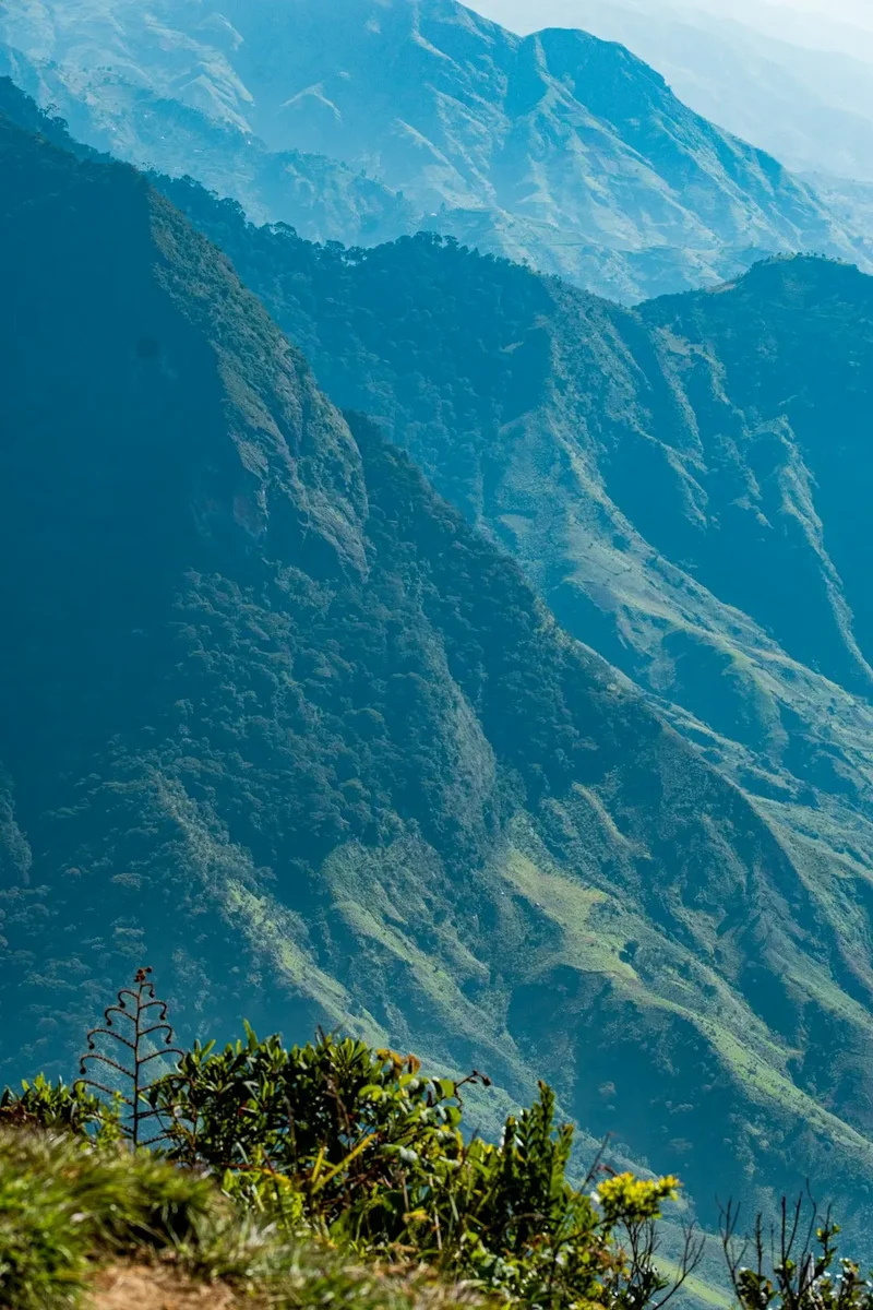
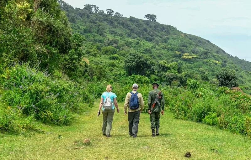
The mountain is defined by its horseshoe-shaped caldera, the result of a massive volcanic explosion approximately 250,000 years ago that blew away the entire eastern wall. This geological cataclysm created the spectacular 1,500-metre cliffs that drop into the "Ash Cone" below, providing one of the most breathtaking vertical drops in East Africa. Because the trail lies within a national park, trekkers are accompanied by an armed park ranger, a unique requirement necessitated by the abundance of wildlife—including buffaloes, giraffes, and elephants—that roam the lower slopes. This is a journey that combines the thrill of a high-altitude mountain expedition with the raw excitement of an African walking safari.
- Distance: 65.0 km (total round trip)
- Duration: 3–4 days
- Season: June to October (dry season) and January to February
- Huts: Miriakamba Hut and Saddle Hut (mandatory)
- Highest point: Socialist Peak (4,562 m)
- Difficulty: Challenging (steep ridges and high altitude)
- Closest City: Arusha, Tanzania
- Trailhead: Momella Gate, Arusha National Park
Overview
The Mount Meru trek is a masterclass in ecological diversity. Within a few days, walkers transition from the lush, humid savannah and montane forests of the lower slopes to the stark, wind-swept alpine deserts of the summit ridge. The journey begins at Momella Gate (1,500 m), where the air is thick with the sounds of tropical birds and the sight of grazing zebras. As you ascend, the forest thickens into a canopy of ancient fig trees and juniper, draped in "old man’s beard" (Usnea) lichens. This zone is home to the striking black-and-white colobus monkeys and the vibrant Hartlaub’s turaco, making the first day of the trek feel more like a nature walk than a mountain climb.
By the second day, the landscape shifts dramatically. The forest gives way to the Hagenia-Hypericum zone, characterized by giant heathers and lobelias. The gradient steepens significantly as you climb toward the Saddle Hut, nestled between the main peak and the smaller, perfectly formed Little Meru. The air becomes thinner, and the vegetation sparser, revealing the true volcanic nature of the mountain. The views from the "Saddle" are legendary, offering a panoramic look at the Maasai Steppe and the distant, shimmering peaks of the Monduli Mountains.
The final push to Socialist Peak is the trek’s defining moment. Unlike the broad, scree-covered slopes of Kilimanjaro, the Meru summit route follows a narrow, rocky ridge known as the "Knife Edge." This section requires a steady head for heights and occasional light scrambling. To your left, the ground drops away into the vast caldera; to your right, the outer slopes of the mountain fall toward the plains. Reaching the summit at dawn is a spiritual experience for many, as the first light of the sun hits the snows of Kilimanjaro on the horizon, casting a giant triangular shadow of Mount Meru across the Tanzanian landscape. It is a challenging, technical, and deeply immersive mountain experience that demands physical fitness and mental resilience.
History and Cultural Context
Mount Meru has long held spiritual significance for the local people, particularly the Wa-Arusha and Meru tribes who live on its fertile lower slopes. To these communities, the mountain is a source of life, providing the water that feeds their coffee and banana plantations. Traditional beliefs often associated the high peaks with the divine, and while the summit was not a common destination for locals in pre-colonial times, the forests were used for ritual purposes and the collection of medicinal plants.
The European history of the mountain began in the late 19th century during the era of German colonial expansion in East Africa. The first recorded ascent of the summit was made in 1904 by Fritz Jaeger, a German geographer and explorer. Jaeger’s expedition mapped the complex caldera system and identified the "Ash Cone," a smaller volcanic vent that grew inside the crater after the original collapse. The mountain was later incorporated into the Arusha National Park, which was established in 1960, ensuring the protection of its unique flora and fauna from the encroachment of agriculture and hunting.
The name of the highest point, Socialist Peak, is a relic of Tanzania’s post-independence history. Following the Arusha Declaration of 1967, under the leadership of President Julius Nyerere, Tanzania adopted a policy of "Ujamaa" or African Socialism. The peak was renamed to reflect the national ideology of the time. While the political landscape has changed, the name remains on official maps and summit plaques. Today, the mountain serves as a symbol of Tanzanian natural heritage, managed by the Tanzania National Parks Authority (TANAPA), and continues to be a vital training ground for Tanzanian mountain guides and rangers before they move on to the higher altitudes of Kilimanjaro.
Want more background? Read extended notes on history and cultural context → Learn more
Seasonal Highlights and Weather Reality
The timing of a Mount Meru trek is critical, as the mountain’s weather is influenced by the Indian Ocean trade winds and its proximity to the equator. There are two distinct dry seasons and two wet seasons, each offering a different experience for the trekker.
The Long Dry Season (June to October): This is widely considered the best time to climb. The skies are generally clear, providing the most reliable views of Mount Kilimanjaro. The temperatures are cooler, which makes the steep ascent more comfortable, though nights at Saddle Hut can drop below freezing. This is also the best time for wildlife viewing, as animals congregate around the remaining water sources in the park.
The Short Dry Season (January to February): Another excellent window for trekking. The weather is typically warmer than in the June–October period. While there may be occasional afternoon clouds, the mornings are usually crisp and clear. This period is popular for those looking to combine a trek with a safari in the Serengeti or Ngorongoro Crater.
The Wet Seasons (March to May and November to December): The "Long Rains" occur from March to May, and trekking during this time is not recommended. The trails become extremely slippery and muddy, and the summit ridge can be dangerous due to high winds and low visibility. The "Short Rains" in November and December are less intense, but trekkers should still expect daily downpours. The advantage of the wet season is the stunning emerald-green landscape and the lack of other trekkers, but the risk of a "white-out" at the summit is high. Snow is possible on the summit at any time of year, but it is most common during these wetter months.
Recommended Itinerary
4-Day Mount Meru Itinerary
Day 1: Momella Gate to Miriakamba Hut
- Distance: 10 km
- Elevation gain: 1,000 m
- Time: 4–5 hours
- Start at Momella Gate (1,500 m) after park registration and meeting your armed ranger.
- The trail begins in open grassland, offering immediate sightings of giraffes, buffaloes, and warthogs.
- Enter the montane forest, passing the massive "Fig Tree Arch," a natural tunnel formed by a strangler fig.
- Cross the Ngare Nanyuki River and continue climbing through the forest canopy.
- Arrive at Miriakamba Hut (2,500 m) in time for a late lunch.
- Afternoon can be spent relaxing or taking a short walk to the nearby crater floor to view the Ash Cone from below.
Day 2: Miriakamba Hut to Saddle Hut
- Distance: 4 km
- Elevation gain: 1,050 m
- Time: 3–4 hours
- The trail steepens significantly today, following a series of wooden steps and switchbacks through the forest.
- As you gain altitude, the forest thins and is replaced by giant heathers and wildflowers.
- Pass "Mgongo wa Tembo" (Elephant Back) ridge, which offers views back down toward the Momella Lakes.
- Arrive at Saddle Hut (3,550 m) located in the col between the main peak and Little Meru.
- OPTIONAL: In the afternoon, take a 1-hour return hike to the summit of Little Meru (3,820 m) for acclimatisation and spectacular sunset views.
- Early dinner and bed, as the summit push begins at midnight.
Day 3: Saddle Hut to Socialist Peak and back to Miriakamba Hut
- Distance: 14 km
- Elevation: 1,012 m gain to summit, 2,062 m descent
- Time: 10–12 hours
- Wake up at midnight for a light snack and tea.
- Begin the steep climb to Rhino Point (3,800 m) under starlight.
- Navigate the "Knife Edge" ridge, a narrow rocky path with steep drops on either side. Some light scrambling is required.
- Reach the summit, Socialist Peak (4,562 m), just as the sun rises over Mount Kilimanjaro.
- After celebrating at the summit, descend back to Saddle Hut for a hot brunch.
- Continue the descent down to Miriakamba Hut (2,500 m) for your final night on the mountain.
- This is a long, physically demanding day that tests your endurance and knee strength.
Day 4: Miriakamba Hut to Momella Gate
- Distance: 10 km
- Elevation: 1,000 m descent
- Time: 2–3 hours
- Take a different route down (the "Southern Route") which passes through the lower forest and open plains.
- This route offers more opportunities for wildlife spotting, particularly in the early morning.
- Pass through the "Tululusia Waterfall" area, a beautiful spot for final photos.
- Arrive back at Momella Gate to collect your summit certificates and meet your transport.
- Transfer back to Arusha for a well-earned shower and celebration meal.
Important Notes:
- The 4-day itinerary is strongly recommended over the 3-day version to allow for better acclimatisation and a more enjoyable descent.
- An armed ranger is mandatory for all groups due to the presence of large wildlife.
- The summit ridge can be very windy and cold; high-quality windproof layers are essential.
- Water is available at the huts but must be treated or filtered.
Planning and Bookings
Book Your Trip
Everything you need to plan your journey
Accommodation
Find places to stay near Arusha
Flights
Search flights to Arusha
Essential Preparation
Planning a Mount Meru trek requires more than just physical training; it involves coordinating with the Tanzania National Parks Authority (TANAPA) and usually a local tour operator. While it is technically possible to organise the trek independently at the park gate, it is highly discouraged. Most trekkers book through an agency in Arusha that provides a guide, a cook, porters to carry gear, and the mandatory armed ranger. Arusha is the primary gateway for the trek, located about 45 minutes from the Momella Gate. It is a vibrant city with a wide range of accommodation, from budget hostels to luxury safari lodges.
Physical preparation should focus on cardiovascular endurance and leg strength. The second and third days involve significant elevation gain over short distances, and the descent on Day 3 is particularly taxing on the joints. Trekkers should be comfortable walking 6–8 hours a day with a light daypack. If you are using Meru as acclimatisation for Kilimanjaro, ensure you have at least two days in Arusha beforehand to adjust to the local environment and recover from international flights.
Trail Accommodation
Accommodation on Mount Meru is provided in permanent wooden huts managed by TANAPA. Unlike Kilimanjaro, where many routes require camping, Meru offers a more sheltered experience. However, these are basic mountain huts, not luxury lodges.
Hut Facilities:
- Dormitory-style rooms with bunk beds and foam mattresses.
- Separate dining halls where meals are served by your trekking crew.
- Basic solar lighting (though often unreliable, so head torches are essential).
- Shared pit latrines or basic flush toilets (depending on water availability).
- Outdoor washing areas with cold water.
What Huts Don't Provide:
- Bedding, pillows, or sleeping bags (you must bring your own).
- Heating (huts can be very cold at night, especially at Saddle Hut).
- Charging stations for electronics (bring power banks).
- Showers or hot running water.
- WiFi or reliable mobile signal.
Booking Requirements:
- Hut fees are paid as part of your park entrance permits.
- Space is limited, especially during the peak dry season, so booking through an operator 2–3 months in advance is recommended.
- Costs for the huts are approximately US$30 per person per night (subject to change by TANAPA).
Required Gear
- Hiking Boots: High-quality, waterproof boots with good ankle support. Ensure they are well broken-in to avoid blisters.
- Sleeping Bag: A 4-season bag rated to at least -10°C. Even in the tropics, temperatures at 3,500 m can drop significantly at night.
- Clothing Layers: Moisture-wicking base layers (merino wool is best), a fleece or down mid-layer, and a waterproof/windproof outer shell.
- Head Torch: Essential for the midnight summit start and navigating the huts at night. Bring spare batteries.
- Backpack: A 30–40L daypack for your essentials (water, snacks, layers), while porters carry your main duffel bag (limited to 15 kg).
- Trekking Poles: Highly recommended for the steep descent from the summit to Miriakamba Hut to protect your knees.
- Gloves and Beanie: Essential for the summit night when wind chill can be severe.
What to Bring
- Water Treatment: Purification tablets or a filter (e.g., Sawyer Squeeze). While water is provided, it is sourced from mountain streams and needs treatment.
- High-Energy Snacks: Trail mix, energy bars, and electrolytes. Your appetite may decrease at altitude, so bring foods you enjoy.
- Sun Protection: SPF 50+ sunscreen, lip balm with SPF, and polarized sunglasses. The UV radiation is intense at 4,500 m.
- Personal First Aid: Include blister pads (Compeed), ibuprofen, rehydration salts, and any personal medications.
- Altitude Medication: Consult your doctor about Diamox (Acetazolamide) if you are concerned about altitude sickness.
- Toiletries: Biodegradable wet wipes (for "mountain showers"), hand sanitizer, and a small towel.
- Cash: Small denominations of US Dollars or Tanzanian Shillings for tipping your guides, porters, and ranger at the end of the trek.
Permits
Access to Mount Meru is strictly regulated by the Tanzania National Parks Authority (TANAPA). You cannot simply show up and start walking; you must obtain a series of permits and pay the required fees at the Momella Gate. If you are booking through a tour operator, these fees are usually included in your package price, but it is important to verify this.
Fee Structure (Subject to Change):
- Conservation Fee: Approximately US$45 per adult per 24 hours.
- Hut Fee: Approximately US$30 per person per night.
- Rescue Fee: Approximately US$20 per person per trip (covers basic evacuation to the gate).
- Ranger Fee: Approximately US$20–$25 per group per day. This is mandatory for safety against wildlife.
- Guide and Porter Fees: These are separate from park fees and are paid to the staff or through your agency.
Important Regulations:
- You must present your original passport at the Momella Gate for registration.
- Permits are only valid for the duration specified; if you stay an extra night due to exhaustion or weather, additional fees will apply.
- Payment at the gate is typically done via credit card or a government electronic payment system (GePG); cash is often not accepted for official fees.
- The mandatory armed ranger is assigned by the park at the gate. You do not need to find your own ranger, but you must wait for one to be available before starting.
Other Activities in the Area
Arusha National Park and the surrounding region offer a wealth of activities that can be enjoyed before or after your trek:
- Canoeing on Momella Lakes: A peaceful way to see hippos, flamingos, and waterbuck from a different perspective. The lakes are alkaline and attract a huge variety of birdlife.
- Walking Safaris: If you haven't had enough walking, the lower plains of the park offer guided walks where you can get remarkably close to giraffes and zebras on foot.
- Ngurdoto Crater: Often called "Little Ngorongoro," this swampy caldera is a haven for buffaloes and warthogs. While you cannot descend into the crater, the rim offers spectacular viewpoints.
- Arusha City Tour: Visit the Central Market, the Maasai Market for souvenirs, and the Cultural Heritage Centre to learn about Tanzania’s 120+ tribes.
- Coffee Plantation Tours: The slopes of Mount Meru are famous for Arabica coffee. Many local farms offer tours showing the process from bean to cup.
- Meserani Snake Park: Located just outside Arusha, this is a great place to see Africa’s most dangerous reptiles in a safe environment and visit a Maasai cultural museum.
Safety and Conditions
Altitude Sickness (AMS): Despite being lower than Kilimanjaro, Mount Meru is high enough to cause Acute Mountain Sickness. The ascent is rapid (over 1,000 m per day), which increases the risk. Symptoms include headache, nausea, dizziness, and loss of appetite. The best prevention is to "pole pole" (walk slowly), drink at least 3–4 litres of water daily, and consider the 4-day itinerary for better acclimatisation. If symptoms persist or worsen, the only cure is descent.
The Summit Ridge: The "Knife Edge" between Rhino Point and Socialist Peak is the most technical part of the trek. It involves walking along a narrow ridge with significant exposure. In high winds or icy conditions, this section can be dangerous. Always follow your guide’s instructions, and do not hesitate to turn back if the weather turns or if you feel unsafe. The rock can be slippery when wet or covered in morning frost.
Wildlife Encounters: Because you are walking in a national park with "Big Five" animals (excluding lions, though leopards are present), the armed ranger is a non-negotiable safety requirement. Buffaloes are the primary concern; they can be unpredictable and aggressive if startled. Always stay behind the ranger and keep a respectful distance from all animals. Never attempt to feed or approach wildlife.
Weather Extremes: Conditions can change from hot and humid in the forest to sub-zero and windy on the summit within hours. Hypothermia is a real risk if you are not properly layered. Ensure your waterproof gear is easily accessible in your daypack. During the rainy season, lightning is a significant hazard on the exposed ridges.
Emergency Evacuation: There are no helicopter rescue services directly on Mount Meru. In the event of an injury or severe AMS, you will be carried down by porters on a wheeled stretcher to the nearest point accessible by a 4WD park vehicle. Ensure your travel insurance specifically covers trekking up to 5,000 m.
Side Trips and Points of Interest
Little Meru (3,820 m): Located just a short hike from Saddle Hut, Little Meru is the perfect afternoon excursion on Day 2. The climb takes about 45 minutes and provides an excellent vantage point to see the sheer cliffs of the main peak and the Ash Cone. It is also a great way to test how your body is reacting to the altitude before the midnight summit push.
The Ash Cone: This is a perfectly formed volcanic cone located inside the main caldera. While the standard trekking route views it from above, it is a stark reminder of the mountain’s recent volcanic activity (the last minor eruption was in 1910). The contrast between the dark volcanic ash and the surrounding green cliffs is a photographer’s dream.
Fig Tree Arch: Located on the first day’s trail, this is a massive Ficus thonningii that has grown across the path, creating an archway large enough for a safari vehicle to drive through. It is a sacred site for local communities and a highlight of the montane forest zone.
Tululusia Waterfall: A 28-metre high waterfall located near the Momella Gate. It is a popular spot for a final break on the descent, where you can cool off in the mist and look for the red-winged starlings that nest in the surrounding cliffs.
Rhino Point: A rocky outcrop at 3,800 m on the summit route. While rhinos are no longer found on the mountain, the point is named after the bones found there years ago. It offers the first clear view of the summit ridge and is often the place where trekkers decide whether to continue or turn back based on the weather and their physical state.
Leave No Trace
Arusha National Park is a fragile ecosystem that faces increasing pressure from tourism and climate change. As a trekker, it is your responsibility to minimize your impact on this pristine environment. The "Leave No Trace" principles are strictly enforced by park rangers and should be followed by every visitor.
Your responsibility as a walker:
- Pack it in, pack it out: Ensure all trash, including small items like cigarette butts and candy wrappers, is carried back to the gate. Your trekking crew will manage the main waste, but keep an eye on your own micro-trash.
- Stay on the trail: The volcanic soil on Meru is highly susceptible to erosion. Cutting switchbacks destroys vegetation and creates gullies that wash away the trail during the rains.
- Respect the wildlife: Do not shout or make loud noises to get an animal’s attention. Observe from a distance and never leave food behind, as this habituates animals to human presence.
- Water Protection: Do not use soap or detergents in the mountain streams. If you need to wash, carry water 30 metres away from the source and use biodegradable soap.
- No Fire: Open fires are strictly prohibited in the park. All cooking is done on gas stoves by your crew.
- Toilet Etiquette: Use the facilities provided at the huts. If you are caught short on the trail, bury waste in a "cathole" at least 15 cm deep and 60 metres from water, and pack out your toilet paper in a sealed bag.
By following these guidelines, you help ensure that Mount Meru remains a wild and beautiful destination for the next generation of adventurers.