Mount Kinabalu Trek (Day Section) - The Granite Throne of Borneo
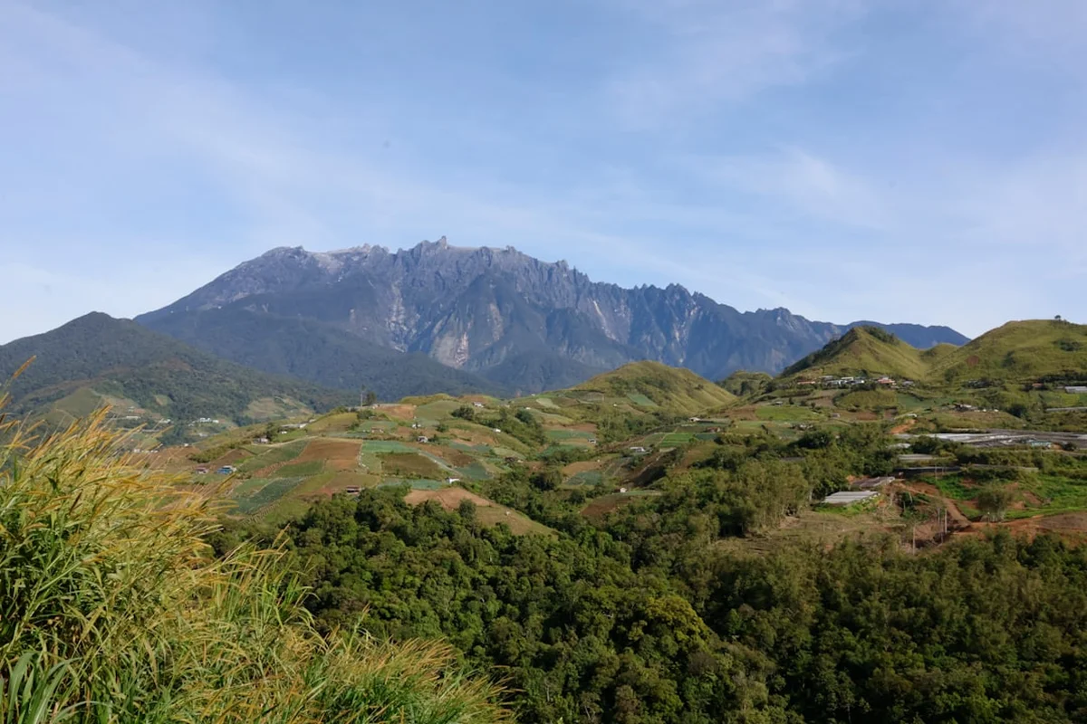
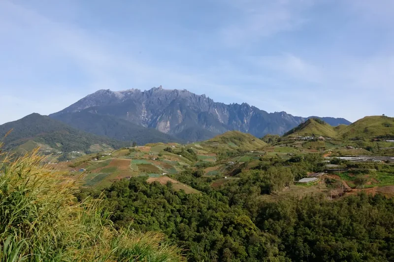
The Mount Kinabalu Trek is the crown jewel of Malaysian mountaineering, a formidable ascent that carries hikers from the humid tropical rainforests of Borneo to the stark, wind-swept granite plateaus of the highest peak between the Himalayas and New Guinea. Located within the UNESCO World Heritage-listed Kinabalu Park in Sabah, this 8.7 km journey is a vertical odyssey through one of the most biologically diverse environments on Earth. The "Day Section" of this trek represents the primary ascent phase, a relentless climb that tests physical endurance and mental fortitude as the oxygen thins and the landscape transforms from lush emerald canopies to prehistoric-looking sub-alpine scrub. Rising to a height that pierces the clouds, the trek offers a rare opportunity to witness the geological drama of a mountain that is still growing, rising at a rate of approximately five millimetres per year.
- Distance: 8.7 km (one-way to summit area)
- Elevation Gain: 1,327 m
- Duration: 4–6 hours (ascent phase)
- Difficulty: Very Challenging
- Best Time: March to September (dry season)
- Closest City: Kota Kinabalu, Sabah, Malaysia
- Trailhead: Timpohon Gate (1,866 m)
- Status: UNESCO World Heritage Site / National Park
Overview
Mount Kinabalu is not merely a mountain; it is a biological island in the sky. The trek is world-renowned for its staggering botanical richness, housing more than 5,000 species of vascular plants, 90 species of lowland mammals, and over 300 species of birds. As you begin the 8.7 km ascent from the Timpohon Gate, you are entering a landscape that has fascinated naturalists since the mid-19th century. The trek is characterised by its "staircase" nature—thousands of man-made and natural steps carved into the mountainside, designed to manage the steep gradient and protect the fragile soil from erosion caused by the thousands of hikers who visit annually.
The journey is divided into distinct climatic zones, each with its own unique atmosphere. The initial kilometres wind through the Lowland and Hill Montane Forest, where the air is thick with humidity and the scent of damp earth. Here, towering dipterocarp trees compete for sunlight, and the forest floor is a tangle of ferns and mosses. As you pass the 2,000-metre mark, the forest transitions into the Cloud Forest or Upper Montane zone. This is a realm of perpetual mist, where trees are gnarled and stunted, draped in "Old Man's Beard" lichens and epiphytic orchids. It is in this zone that hikers often encounter the famous Nepenthes pitcher plants, including species found nowhere else on the planet.
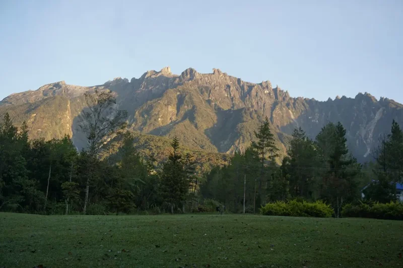
The final stretch of the day section leads toward the Panalaban plateau, where the vegetation thins out into sub-alpine meadows. The granite massif begins to dominate the horizon—a massive, grey wall of rock that feels entirely disconnected from the tropical island below. The physical challenge of this trek cannot be overstated; the 1,327-metre elevation gain over a relatively short distance requires significant cardiovascular fitness and leg strength. However, the reward is a profound sense of achievement and a front-row seat to one of the most dramatic geological transitions in the natural world. Whether you are a seasoned mountaineer or a determined adventurer, the Mount Kinabalu trek is a transformative experience that demands respect and offers unparalleled beauty.
History and Cultural Context
For the local Kadazan-Dusun people of Sabah, Mount Kinabalu is far more than a trekking destination; it is "Aki Nabalu," the "Revered Place of the Dead." According to indigenous belief, the spirits of their ancestors dwell on the summit, and the mountain is treated with the utmost sanctity. Historically, the local people would perform rituals and sacrifices to appease the spirits before attempting to climb the higher reaches. Even today, an annual "Monogit" ceremony is performed by a Bobohizan (high priestess) to maintain the spiritual balance between the human world and the mountain's guardians. This cultural depth adds a layer of solemnity to the trek, reminding hikers that they are guests in a sacred space.
The first recorded ascent by a non-indigenous person was made in 1851 by Sir Hugh Low, a British colonial administrator and naturalist. Low did not actually reach the highest peak (which now bears his name, Low's Peak), as he believed the summit plateau was inaccessible. It wasn't until 1888 that zoologist John Whitehead successfully reached the true summit. These early expeditions were monumental undertakings, requiring weeks of travel through dense jungle and the recruitment of dozens of local porters. The botanical specimens collected during these trips—including the giant Nepenthes rajah pitcher plant—stunned the scientific community in Europe and established Kinabalu as a global hotspot for biodiversity.
In recent history, the mountain has shown its volatile side. In June 2015, a 6.0 magnitude earthquake struck the region, causing massive rockfalls on the summit plateau and tragically claiming the lives of 18 people, including several young students and guides. The disaster led to a temporary closure of the mountain and a complete redesign of the trekking routes. The current "Ranau Trail" and "Kota Belud Trail" were constructed with improved safety features and better gradients, serving as a testament to the resilience of the Sabah Parks rangers and the local mountain guide community. Today, the trek stands as a symbol of Sabah's natural heritage and the enduring spirit of the people who call the mountain home.
Want more background? Read extended notes on history and cultural context → Learn more
Seasonal Highlights and Weather Reality
Mount Kinabalu's weather is notoriously unpredictable, influenced by its height and its position between the South China Sea and the Sulu Sea. The mountain experiences two distinct seasons, though rain can occur at any time of the year. Understanding these patterns is crucial for a successful and safe ascent.
The Dry Season (March to September): This is generally considered the best time to trek. During these months, the probability of clear skies is higher, providing spectacular views of the surrounding valleys and the distant coastline. March and April are particularly favoured as they often coincide with the flowering season of many mountain orchids and rhododendrons. However, even in the dry season, afternoon tropical downpours are common. Hikers should aim to complete the day section as early as possible to avoid the mist and rain that typically roll in after 2:00 PM.
The Wet Season (October to February): The northeast monsoon brings heavier and more frequent rainfall to Sabah. While the park remains open, trekking during this period is significantly more challenging. The trails can become slippery, and the temperature drops more sharply. Most importantly, Sabah Parks may close the summit section (beyond Panalaban) if weather conditions are deemed dangerous due to high winds or heavy rain. If you choose to trek during these months, you must be prepared for the possibility of being unable to reach the summit, and your gear must be top-tier to handle the constant moisture.
Temperature Variations: Temperature is a critical factor on Kinabalu. At the Kinabalu Park HQ (1,563 m), temperatures are a pleasant 20°C to 25°C. However, as you ascend the day section toward Panalaban (3,272 m), the temperature can drop to 10°C or lower. At the summit during the pre-dawn hours, it is not uncommon for temperatures to hover between 0°C and 5°C, with wind chill making it feel much colder. Proper layering is essential to manage these extremes.
Recommended Itinerary
Mount Kinabalu Day Section Itinerary
Early Morning: Registration and Departure
- 07:00 – 08:00: Arrive at Kinabalu Park Headquarters for registration. Ensure you have your climbing permit and have been assigned a mandatory mountain guide.
- 08:30: Take the park shuttle from the HQ to Timpohon Gate (1,866 m), the official starting point of the trek.
- 09:00: Begin the ascent. The first kilometre is a gentle introduction, passing the Carson Fall shortly after the gate.
- The trail is well-marked with kilometre markers and "Pondoks" (shelters) located approximately every kilometre.
Mid-Morning: The Montane Forest Ascent
- 09:00 – 11:00: Trek from Timpohon Gate to Layang-Layang Hut (2,702 m). This 4 km stretch involves a steady climb through the montane forest.
- Pass Pondok Kandis (KM 1.5), Pondok Ubah (KM 2.0), and Pondok Lowii (KM 2.5).
- Take short breaks at each shelter to hydrate and adjust layers. The humidity will begin to drop as you gain altitude.
- 11:00: Reach Layang-Layang Hut (also known as Carson’s Camp). This is a major milestone where the trail from Mesilau (currently closed) used to join the main track.
Midday: The Transition Zone
- 11:30 – 13:00: Continue from Layang-Layang toward the Panalaban plateau. This section is steeper and more rugged.
- Pass Pondok Villosa (KM 5.0) and Pondok Paka (KM 5.5). The vegetation noticeably changes here; look for the gnarled leptospermum trees and wild orchids.
- The air becomes thinner, and your pace will likely slow. Focus on steady, rhythmic breathing.
- 13:00: Reach the Panalaban base (3,272 m). This area houses the various mountain huts, including Laban Rata Resthouse.
Afternoon: Arrival and Acclimatisation
- 13:30 – 15:00: Check into your assigned accommodation (Laban Rata, Pendant Hut, or similar).
- Eat a late lunch and spend the afternoon resting. This is a critical period for acclimatisation.
- Explore the immediate area around Panalaban. The views of the granite peaks above and the clouds below are breathtaking.
- 17:00 – 19:00: Early dinner at the Laban Rata restaurant. Most hikers retire early (by 8:00 PM) to prepare for the summit push the following morning.
Important Notes:
- The "Day Section" described here is the standard first day of a 2-day/1-night trek.
- One-day permits are extremely rare and usually reserved for the annual International Climbathon participants.
- Always stay with your guide; they are experts in pacing and identifying signs of altitude sickness.
- Water is available at most shelters, but it is untreated; use purification tablets or carry sufficient bottled water.
Planning and Bookings
Book Your Trip
Everything you need to plan your journey
Accommodation
Find places to stay near Kota Kinabalu
Flights
Search flights to Kota Kinabalu
Essential Preparation
Planning a Mount Kinabalu trek requires significant lead time, often six months or more. The primary constraint is the limited number of climbing permits issued by Sabah Parks (currently capped at approximately 163 per day). You must coordinate three things: your climbing permit, your mountain guide, and your accommodation at Panalaban. Most hikers book through authorised tour operators who package these elements together, simplifying the logistics.
Physical preparation is vital. While the trail is technically straightforward (mostly stairs and well-defined paths), the sheer volume of steps is punishing on the knees and calves. Training should focus on cardiovascular endurance and "stair-climbing" muscles. If possible, spend at least one night in Kundasang (the base town) before your climb to begin the acclimatisation process at 1,500 metres. Kundasang offers various lodges and hotels, as well as local markets for last-minute supplies.
Trail Accommodation
Accommodation on the mountain is concentrated at the Panalaban plateau (3,272 m). These huts are the only legal places to stay overnight on the mountain. Due to the remote location, facilities are functional rather than luxurious, but they provide essential shelter and warmth.
Hut Facilities:
- Laban Rata Resthouse: The largest and most well-equipped hut. It features dormitory-style bunk beds, a heated restaurant, and shared bathroom facilities. It is the only hut with a dining hall serving hot buffet meals.
- Pendant Hut: Specifically for those participating in the Via Ferrata. It offers a more intimate atmosphere and mandatory pre-climb briefings.
- Other Huts (Lemaing, Panalaban Hostel): Basic dormitory accommodation for Malaysian hikers and specific tour groups.
- Electricity is available but can be intermittent. There are no charging ports in the dorms; bring a power bank.
- Shared bathrooms have cold water showers (though most hikers skip showering due to the cold).
What Huts Don't Provide:
- Towels and toiletries (unless staying in private rooms at Laban Rata).
- Personal medication or oxygen.
- WiFi or reliable mobile signal (though some spots near Laban Rata have weak 4G).
- Heating in the sleeping quarters (except for the main Laban Rata building).
Required Gear
- Hiking Boots: Must have excellent grip and be well broken-in. Waterproofing is highly recommended.
- Layered Clothing: A moisture-wicking base layer, a fleece or down mid-layer, and a high-quality waterproof outer shell.
- Headlamp: Essential for the summit push, but also useful in the huts at night. Bring spare batteries.
- Gloves: Waterproof gloves are necessary for the summit section where you may need to hold onto ropes.
- Backpack: A 30–40L pack with a rain cover. If you hire a porter, you only need a small daypack for essentials.
- Walking Poles: Highly recommended to save your knees during the steep descent.
What to Bring
- High-Energy Snacks: Chocolate, nuts, energy bars, and dried fruit to supplement provided meals.
- Water Treatment: Purification tablets or a filtered water bottle. While water is provided at Laban Rata, trail water is untreated.
- Personal First Aid: Blister pads, paracetamol, altitude sickness medication (consult a doctor first), and knee supports.
- Sun Protection: SPF 50+ sunscreen, lip balm with UV protection, and sunglasses. The UV rays are intense at 3,000m+.
- Toiletries: Toothbrush, toothpaste, wet wipes, and a small travel towel.
- Identification: You must carry your passport (international) or IC (Malaysian) for permit verification at checkpoints.
Permits
Securing a permit is the most critical step in your Kinabalu journey. Permits are strictly controlled by Sabah Parks to prevent overcrowding and protect the environment. There are no "walk-in" permits; everything must be arranged in advance.
Booking Process:
- Sutera Sanctuary Lodges (SSL): They manage the majority of the accommodation at Panalaban. You can book directly through their website, but spots fill up almost instantly when released.
- Authorised Travel Agents: Most international trekkers use agents who secure blocks of permits and accommodation. This is often the most reliable way to guarantee a spot.
- Sabah Parks: A small number of permits are reserved for Malaysian citizens and can be applied for through the Sabah Parks booking office in Kota Kinabalu.
Mandatory Requirements:
- Mountain Guide: It is a legal requirement to have a registered mountain guide. The ratio is usually 1 guide to 5 hikers. They are responsible for your safety and ensuring you follow park regulations.
- Climbing Insurance: A basic insurance policy is included in your permit fee, but it is highly recommended to have your own comprehensive travel insurance that covers high-altitude trekking and emergency evacuation.
- Checkpoints: You must show your climbing ID tag at Timpohon Gate, Layang-Layang, and Sayat-Sayat. Failure to do so will result in being turned back.
Costs (Approximate):
- Permit Fee: RM 400 (International Adult), RM 100 (Malaysian Adult).
- Mountain Guide: RM 230–300 per guide (shared among the group).
- Park Entrance: RM 50 (International), RM 10 (Malaysian).
- Accommodation/Food Packages: These vary wildly but typically range from RM 1,500 to RM 2,500 for a 2D1N package.
Other Activities in the Area
The region surrounding Kinabalu Park, known as Kundasang and Ranau, offers several attractions that are perfect for post-hike recovery or for non-climbing companions:
- Poring Hot Springs: Located about 45 minutes from the Park HQ, these natural sulphur baths are the ultimate cure for sore muscles. The site also features a canopy walkway and a butterfly farm.
- Desa Dairy Farm: Often called the "Little New Zealand of Sabah," this farm offers stunning views of the mountain's eastern face, fresh milk, and gelato.
- Kundasang War Memorial: A beautifully maintained garden and memorial dedicated to the British and Australian soldiers who died in the Sandakan Death Marches during WWII.
- Kinabalu Park Botanical Garden: For those who want to see the mountain's flora without the 1,300m climb, this guided walk near the HQ is excellent.
- Marakau Big Fish Foot Spa: A unique experience in Ranau where large koi fish "massage" your feet in a natural river setting.
Safety and Conditions
Altitude Sickness (AMS): Acute Mountain Sickness is the most common challenge on Kinabalu. Because the ascent is rapid (starting at 1,800 m and reaching 3,200 m in a few hours), the body has little time to adapt. Symptoms include headache, nausea, dizziness, and fatigue. The best prevention is to climb slowly ("slow and steady" is the guide's mantra), drink plenty of water, and avoid alcohol. If symptoms become severe, the only cure is immediate descent.
Weather Hazards: Rain can turn the granite surfaces into slippery slides. In the event of lightning or extreme winds, the summit section will be closed. Always follow your guide's instructions without question; they receive real-time radio updates on weather conditions from the rangers at the summit.
Physical Limits: The descent is often harder on the body than the ascent. The repetitive impact of descending thousands of steps can lead to "jelly legs" and increased risk of trips or falls. Use trekking poles and take frequent short breaks to maintain focus.
Emergency Evacuation: In the event of a serious injury, the mountain guides and rangers perform manual evacuations using stretchers or by carrying the injured person on their backs. There is no helicopter rescue service that can land on the higher reaches of the mountain due to the unpredictable winds and terrain.
Side Trips and Points of Interest
The Via Ferrata: For those seeking an extra adrenaline rush, Mount Kinabalu hosts the world's highest "Iron Road." Starting near the summit, hikers can choose between "Walk the Torq" (easier) or "Low's Peak Circuit" (more challenging). This involves traversing the granite face using a system of cables, rungs, and bridges. It must be pre-booked and requires a stay at Pendant Hut.
Pondok Paka: Near the 5.5 km mark, this small shelter sits near a cave where early explorers used to camp. It is a place of historical significance and offers a glimpse into the "old way" of climbing the mountain before the modern huts were built.
The Sayat-Sayat Checkpoint: At 3,668 m, this is the highest permanent structure on the mountain. While technically part of the summit push (Day 2), it is a vital landmark for the day section's conclusion, marking the transition from the "vegetated" mountain to the "naked" granite dome.
Carson Fall: Located near the start of the trek, this waterfall is a beautiful spot for a final photo before the serious climbing begins. It is named after the first Warden of Kinabalu Park.
Leave No Trace
As a UNESCO World Heritage site and a sacred mountain, maintaining the environmental integrity of Kinabalu is a collective responsibility. The park operates a strict "carry-in, carry-out" policy.
Guidelines for Responsible Trekking:
- Waste Management: Do not leave any litter on the trail or in the shelters. This includes organic waste like fruit peels, which can take a long time to decompose in the cool mountain air and can disrupt the diet of local wildlife.
- Flora and Fauna: It is strictly forbidden to pick any plants, flowers, or seeds. Many species on Kinabalu are endangered and exist only in specific micro-climates. Similarly, do not feed the squirrels or birds at the shelters.
- Water Protection: Do not use soaps or detergents in the mountain streams. Use the provided facilities at the huts.
- Stay on the Path: Veering off the trail causes soil compaction and destroys fragile mosses and orchids. The trail is clearly defined for a reason.
- Respect the Silence: Keep noise levels to a minimum. This allows you and others to enjoy the natural sounds of the forest and shows respect for the spiritual nature of the mountain.