Mount Kinabalu Climb - The Roof of Borneo
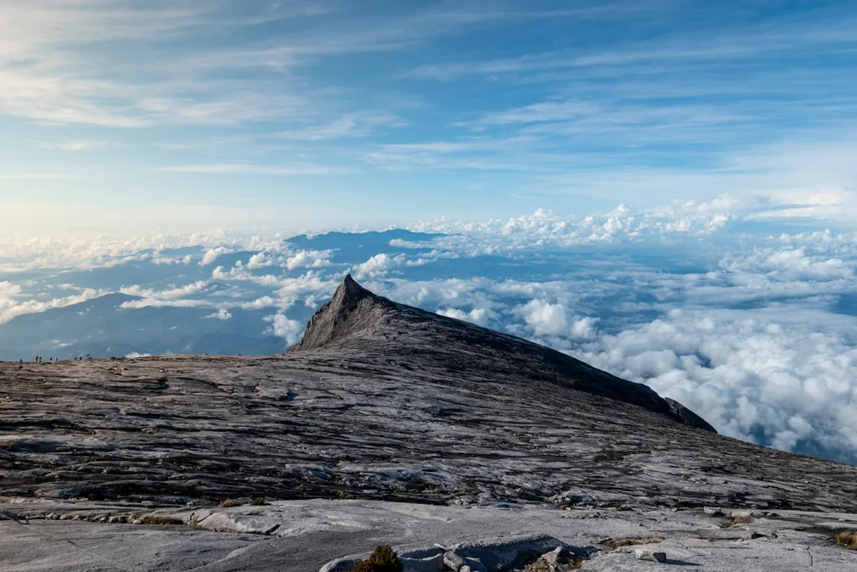
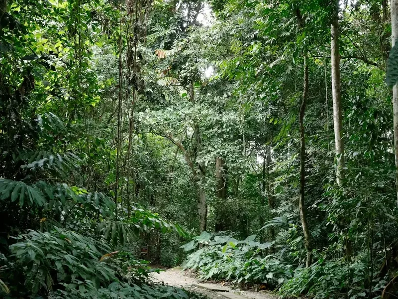
Mount Kinabalu stands as the majestic crown of Sabah, Malaysia, rising to a formidable 4,095.2 metres above sea level. As the highest peak between the Himalayas and New Guinea, it is the centrepiece of Kinabalu Park, Malaysia’s first UNESCO World Heritage Site. This is not merely a mountain; it is a biological island in the sky, home to one of the world’s most diverse collections of flora and fauna. The climb is a rite of passage for adventurers visiting South East Asia, offering a journey through distinct ecological zones—from lush lowland rainforests and montane oak forests to the stark, wind-swept granite plateau of the summit. Unlike many Himalayan peaks of similar stature, Mount Kinabalu is accessible to anyone with a good level of fitness and determination, requiring no specialised mountaineering equipment or technical climbing skills for the standard route. However, the sheer elevation gain of over 2,200 metres over a relatively short distance makes it a significant physical challenge that demands respect and preparation. Standing on Low’s Peak at dawn, watching the shadow of the mountain cast across the clouds of the Crocker Range, is an experience that defines a lifetime of travel.
- Distance: 8.7 km one-way (17.4 km return)
- Duration: 2 days / 1 night (3-day options available)
- Season: March to September (Dry season; climbing is possible year-round but weather dependent)
- Accommodation: Panalaban Base Camp (Laban Rata Resthouse and surrounding huts)
- Highest point: Low’s Peak (4,095.2 m)
- Daily climbers: Strictly limited to approximately 163 permits per day
- Direction: Out-and-back via Timpohon Gate
Overview
The Mount Kinabalu climb is a vertical odyssey that compresses a continent's worth of biodiversity into a single trail. The journey begins at Timpohon Gate (1,866 m), where the air is humid and the forest is a dense tapestry of tropical hardwoods and giant ferns. As you ascend, the landscape undergoes a dramatic transformation. By the time you reach the mid-way point at Layang-Layang (2,702 m), the tropical heat gives way to a cool, misty montane climate where moss-draped trees and carnivorous pitcher plants (Nepenthes) thrive. The final push to the Panalaban Base Camp (3,272 m) reveals the sub-alpine zone, where vegetation becomes stunted and hardy. The overnight stay at Panalaban is a communal experience, where climbers from across the globe gather to rest before the midnight summit attempt. The second day is the climax: a 2:00 AM start under a canopy of stars, navigating the massive granite slabs of the summit plateau by headlamp. The final scramble to Low’s Peak is a test of lung capacity and mental fortitude, rewarded by a sunrise that illuminates the jagged peaks of the Donkey’s Ears, St. John’s Peak, and the terrifying depths of Low’s Gully.
Geologically, Mount Kinabalu is a young mountain, a massive pluton of granite that was thrust upwards through the surrounding sedimentary rock only a few million years ago. It continues to rise at a rate of about five millimetres per year. This geological youth is evident in the sharp, uneroded features of the summit peaks. The mountain is also a "hotspot" of endemism; many of the species found here, including the world's largest pitcher plants and hundreds of orchid species, exist nowhere else on Earth. For the climber, this means every step is a walk through a living museum. The trail itself is well-maintained, consisting of a mix of earthen paths, wooden stairs, and rock-hewn steps. While the path is clear, the physical toll of climbing thousands of steps cannot be understated. It is a relentless upward grind that tests the quadriceps and the cardiovascular system, but the infrastructure—including frequent rest shelters (pondoks) with toilets and water—makes the ordeal manageable for the well-prepared hiker.
The cultural weight of the mountain is as significant as its physical height. To the local Kadazan-Dusun people, Kinabalu is "Aki Nabalu"—the revered place of the dead. They believe the spirits of their ancestors reside on the summit, and the mountain is treated with deep spiritual reverence. This connection adds a layer of solemnity to the climb; you are not just conquering a peak, but visiting a sacred site. The presence of mandatory local guides is not just a safety requirement but a bridge to this local heritage, ensuring that every climber respects the traditions and the environment of this extraordinary Malaysian icon.
History and Cultural Context
The history of Mount Kinabalu is a blend of indigenous mythology and colonial exploration. For centuries, the Kadazan-Dusun people lived in the shadow of the mountain, viewing it as the final resting place for the souls of the departed. Traditional beliefs held that the spirits of the dead would climb the mountain to wait for their passage into the afterlife. To appease these spirits and ensure the safety of those living nearby, annual sacrifices were performed. Even today, a "Monogit" ceremony is occasionally held by local priestesses (Bobohizan) to appease the mountain spirits, particularly after significant events like the 2015 earthquake. Climbers are encouraged to maintain a respectful demeanour, avoiding loud shouting or disrespectful behaviour, in accordance with these long-standing cultural sensitivities.
The first recorded ascent by a non-indigenous person was made in 1851 by Sir Hugh Low, a British colonial administrator and naturalist. Low did not actually reach the highest point, as he believed the jagged peaks were inaccessible, but the highest summit is named "Low’s Peak" in his honour. It wasn't until 1888 that John Whitehead, a British zoologist, finally reached the true summit. Whitehead’s expedition was a massive undertaking, requiring weeks of trekking through the jungle just to reach the base of the mountain. His success paved the way for future scientific expeditions and, eventually, the birth of the mountain's tourism industry. In 1964, Kinabalu Park was established to protect the mountain and its unique ecosystems, and in 2000, it was designated a UNESCO World Heritage Site, recognising its "outstanding universal value" as a biological site.
In recent decades, the mountain has become famous for the Mount Kinabalu International Climbathon, once dubbed the "World’s Toughest Mountain Race." Elite skyrunners would race from the park gates to the summit and back in under three hours—a feat that seems impossible to the average trekker who takes two days for the same journey. While the race has changed format over the years, it cemented Kinabalu’s reputation as a premier destination for mountain sports. The 2015 earthquake, which caused significant damage to the trail and tragically claimed lives, led to a major restoration of the paths and the creation of the "Ranau Trail" and "Kota Belud Trail," which are the modern routes used today. These new paths were designed with improved safety and sustainability in mind, ensuring the mountain remains accessible for generations to come.
Want more background? Read extended notes on history and cultural context → Learn more
Seasonal Highlights and Weather Reality
Mount Kinabalu’s weather is notoriously unpredictable, influenced by its tropical location and extreme elevation. While the mountain can be climbed year-round, there are distinct seasons that significantly impact the experience and the likelihood of reaching the summit. The Malaysian meteorological cycle generally dictates two main seasons: the dry season and the wet season.
The Dry Season (March to September): This is widely considered the best time to climb. March and April are typically the driest months, offering the highest probability of clear skies and spectacular sunrises. During this period, the trails are less slippery, and the risk of summit closure due to heavy rain is minimal. However, this is also the peak tourist season, meaning permits must be booked many months in advance, and the trails can be crowded. The vegetation is often in full bloom during these months, providing excellent opportunities for orchid and pitcher plant enthusiasts.
The Wet Season (October to January): The northeast monsoon brings heavy rainfall to Sabah during these months. Climbing in the rain is a common reality; the trails can become muddy, and the granite slabs near the summit can be dangerously slick. Most importantly, Sabah Parks authorities will close the summit gate at Sayat-Sayat if weather conditions are deemed unsafe (heavy rain, strong winds, or thick fog). If the gate is closed, climbers are not permitted to proceed to Low’s Peak, and no refunds are given. Despite the rain, the mountain takes on a mystical quality during the wet season, with waterfalls cascading down the granite faces and mist swirling through the ancient forests.
Temperature Variations: Regardless of the season, climbers must prepare for extreme temperature shifts. At the Kinabalu Park HQ (1,563 m), temperatures are a pleasant 20°C to 25°C. At Panalaban Base Camp (3,272 m), the temperature drops to between 6°C and 12°C at night. On the summit at dawn, temperatures frequently hover around freezing (0°C to 3°C), and wind chill can make it feel significantly colder. Hypothermia is a genuine risk for those who are under-dressed, making high-quality layering essential regardless of the month you choose to climb.
Recommended Itinerary
2-Day Mount Kinabalu Summit Climb
Day 1: Timpohon Gate to Panalaban Base Camp
- Distance: 6 km
- Elevation gain: 1,406 m
- Time: 4–6 hours
- 08:00: Register at Kinabalu Park HQ, meet your mandatory mountain guide, and collect your climber ID tag.
- 09:00: Transfer to Timpohon Gate (1,866 m), the official start of the climb.
- 09:30: Begin the ascent. The trail starts with a short descent to Carson Fall before beginning a relentless upward climb.
- 11:00: Reach Layang-Layang Hut (2,702 m), a major rest stop where the montane forest begins to transition into sub-alpine vegetation. This is a common spot for a packed lunch.
- 13:00: Pass through the "Villosa" and "Paka" shelters. The forest thins, and the massive granite walls of the mountain become visible above the treeline.
- 15:00: Arrive at Panalaban Base Camp (3,272 m). Check into your assigned hut (Laban Rata, Pendant Hut, or others).
- 17:00: Early buffet dinner at Laban Rata Resthouse. Watch the sunset above the clouds—one of the most beautiful sights in Borneo.
- 19:00: Early lights out. Rest is crucial for the midnight summit push.
Day 2: Summit Push and Descent to Park HQ
- Distance: 2.7 km to summit, then 8.7 km descent to trailhead
- Elevation: 823 m gain to summit, 2,229 m total descent
- Time: 3 hours to summit, 5–8 hours descent
- 01:30: Wake up for a "supper" (early breakfast) at Laban Rata.
- 02:30: Begin the summit push. The trail consists of steep wooden stairs leading to the Sayat-Sayat Checkpoint (3,668 m), the highest hut on the mountain.
- 03:30: Clear the Sayat-Sayat Checkpoint. Your ID tag will be scanned here. Beyond this point, you walk on the open granite plateau, following a white rope that marks the safe path.
- 05:30: Reach the base of Low’s Peak. The final 100 metres is a steep scramble over broken rock.
- 06:00: Summit Low’s Peak (4,095.2 m). Witness the sunrise over the Sulu Sea and the Crocker Range.
- 07:00: Begin the descent back to Panalaban. This is often the most scenic part of the climb as the full scale of the granite plateau is revealed in daylight.
- 09:00: Arrive back at Panalaban for a second breakfast and to pack your gear.
- 10:30: Begin the long descent back to Timpohon Gate. This is notoriously hard on the knees.
- 15:00: Reach Timpohon Gate. Transfer back to Park HQ to collect your achievement certificate.
- 16:30: Late lunch at the park restaurant before departing for Kota Kinabalu.
Important Notes:
- The summit gate at Sayat-Sayat closes if weather conditions are dangerous.
- Mountain guides are mandatory (1 guide for every 5 climbers).
- Walking sticks/trekking poles are highly recommended for the descent.
- Altitude sickness (AMS) can affect anyone; inform your guide if you feel dizzy or nauseous.
- The Via Ferrata (optional) requires an earlier descent from the summit to meet the 07:30 start time at the starting point.
Planning and Bookings
Book Your Trip
Everything you need to plan your journey
Accommodation
Find places to stay near Kota Kinabalu
Flights
Search flights to Kota Kinabalu
Essential Preparation
The Mount Kinabalu climb requires significant forward planning, primarily due to the strict permit system. Permits are limited to approximately 163 per day and often sell out six months in advance, especially for the dry season. Most climbers book through authorised tour operators who package the permit, mountain guide, accommodation, and transport together. It is highly recommended to base yourself in Kota Kinabalu (KK) for at least one or two nights before the climb to acclimatise to the local time zone and ensure you have all necessary supplies. KK is a two-hour drive from the Park HQ; most climbers arrange a private transfer or take a shared taxi from the Padang Merdeka bus station.
Physical preparation is vital. While not technical, the climb is essentially a 6-kilometre stair-climb on Day 1, followed by a high-altitude scramble on Day 2. Training should focus on cardiovascular endurance and leg strength. Incorporating stair-climbing, hill repeats, and weighted hiking into your routine for at least 2–3 months prior to the trip will significantly increase your enjoyment of the experience. Additionally, ensure you have travel insurance that specifically covers high-altitude trekking (up to 4,100 metres).
Trail Accommodation
All climbers must stay overnight at the Panalaban Base Camp (3,272 m). There is no camping allowed on the mountain. The accommodation is managed by Sutera Sanctuary Lodges and Mountain Torq (for Via Ferrata participants).
Laban Rata Resthouse: The main and most comfortable lodge. It features heated dormitory rooms (though heating is limited), a restaurant serving buffet meals, and a small shop selling snacks and basic supplies. It is the only lodge with a dining hall.
Other Huts: Gunting Lagadan, Panalaban Hostel, and Lemaing Hut provide basic dormitory-style accommodation. These are generally unheated and climbers must walk to Laban Rata for meals. Pendant Hut is reserved exclusively for those participating in the Via Ferrata and offers a more intimate atmosphere with a mandatory safety briefing held there on Day 1.
Facilities Provided: Bunk beds with mattresses, pillows, and blankets are provided. Toilets and shared bathrooms are available, though water is cold. Electricity is available but can be intermittent. There is no WiFi, and mobile signal is patchy at best.
Required Gear
- Footwear: Sturdy hiking boots with good grip and ankle support. Ensure they are broken in to avoid blisters.
- Clothing Layers: Moisture-wicking base layers, a fleece or down mid-layer, and a high-quality waterproof/windproof outer shell.
- Headlamp: Essential for the 2:00 AM summit push. Bring spare batteries.
- Gloves: Waterproof gloves are crucial for the summit plateau where you may need to hold onto the guide ropes.
- Headwear: A warm beanie for the summit and a sun hat for the descent.
- Backpack: A 25–35 litre daypack with a rain cover. If you hire a porter, you only need to carry your essentials.
- Trekking Poles: Highly recommended to save your knees during the 2,200-metre descent.
What to Bring
- Water: At least 1.5–2 litres for the first day. Refills are available at Panalaban (boiled water).
- High-Energy Snacks: Chocolate, energy bars, nuts, and dried fruit for the summit push.
- Personal First Aid: Altitude sickness medication (consult your doctor), painkillers, blister pads, and any personal prescriptions.
- Toiletries: Toothbrush, toothpaste, biodegradable soap, and a small travel towel.
- Sun Protection: SPF 50+ sunscreen and lip balm; the UV rays are intense at 4,000 metres.
- Identification: Your passport or IC is required for registration at Park HQ.
- Cash: Small denominations of Malaysian Ringgit (MYR) for tips for guides/porters and extra snacks at Laban Rata.
Permits
Securing a permit is the most critical step in climbing Mount Kinabalu. Sabah Parks issues a limited number of permits daily to prevent overcrowding and protect the environment. These permits are almost always bundled into "climb packages" offered by Sutera Sanctuary Lodges or private tour agencies. It is very difficult to obtain a "permit only" booking as an independent traveller.
Booking Process:
- Book 6–10 months in advance for peak season (March–August).
- Provide your passport details and full name exactly as they appear on your ID.
- Payment is usually required in full at the time of booking to secure the permit.
- Permits are non-transferable and non-refundable in most cases.
Costs: The cost of a climb package varies significantly depending on the accommodation type and whether you are a Malaysian citizen or an international visitor. As of 2024, international climbers can expect to pay between MYR 2,000 and MYR 3,000 for a standard 2D1N package, which includes the permit, insurance, mountain guide, entrance fees, transfers, and all meals on the mountain. Malaysian citizens receive a significant discount on permit fees.
Mountain Guides: A mountain guide is mandatory for all climbers. The ratio is typically 1 guide to 5 climbers. Guides are local experts who are trained in high-altitude rescue and first aid. They are also invaluable for pacing your climb and sharing knowledge about the mountain's ecology.
Other Activities in the Area
The region surrounding Kinabalu Park offers a wealth of natural and cultural attractions that are perfect for post-climb recovery:
- Poring Hot Springs: Located about 40 kilometres from the Park HQ, these natural hot sulphur springs are the ultimate remedy for sore muscles. The site also features a canopy walkway 40 metres above the forest floor and a butterfly farm.
- Desa Cattle Dairy Farm: Often called the "Little New Zealand of Sabah," this farm in Kundasang offers stunning views of the mountain's eastern face, fresh dairy products, and a chance to see the highland cattle.
- Kinabalu Botanical Garden: Located near the Park HQ, this is one of the best places to see the mountain's rare orchids and pitcher plants without the strenuous climb.
- Kundasang War Memorial: A moving tribute to the Australian and British POWs who died during the Sandakan Death Marches in WWII. The gardens are beautifully maintained and offer quiet reflection.
- Kota Kinabalu Island Hopping: After descending, head back to the coast to visit the Tunku Abdul Rahman Marine Park. Islands like Manukan and Sapi offer white sand beaches and excellent snorkelling.
Safety and Conditions
Altitude Sickness (AMS): Acute Mountain Sickness is the most common challenge on Mount Kinabalu. Because the climb involves a rapid ascent to over 4,000 metres, many climbers experience symptoms such as headaches, nausea, dizziness, and loss of appetite. The best prevention is to climb slowly ("slow and steady" or "jalan-jalan" as the guides say), stay hydrated, and consider taking Diamox (Acetazolamide) after consulting with a medical professional. If symptoms become severe, the only cure is immediate descent.
Weather Hazards: The summit plateau is extremely exposed. In the event of a lightning storm or high winds, the summit will be closed. Never attempt to bypass the Sayat-Sayat checkpoint if it is closed by rangers. The granite can become incredibly slippery when wet; always use the fixed white ropes provided on the steeper sections of the plateau.
Physical Limits: The descent is often more dangerous than the ascent. Fatigue leads to stumbles, and the repetitive impact on the knees can cause injury. Use trekking poles and take frequent short breaks. If you are struggling, porters are available to carry your bag, but they cannot carry people except in emergency rescue situations (which are very expensive).
Emergency Procedures: In the event of a serious injury, Sabah Parks operates a Mountain Search and Rescue (MOSAR) team. Evacuation is typically done by stretcher down the mountain, which is a slow and arduous process. Helicopter evacuations are rare and highly dependent on clear weather and availability.
Side Trips and Points of Interest
The Via Ferrata: For those seeking an extra adrenaline rush, Mount Kinabalu hosts the world’s highest Via Ferrata (Italian for "Iron Road"). There are two routes: "Walk the Torq" (easier, suitable for beginners) and "Low’s Peak Circuit" (more demanding, includes a suspension bridge). These routes allow you to traverse the sheer granite faces of the mountain using a system of rails, rungs, and cables. It offers perspectives of the mountain that standard climbers never see.
Low’s Gully: Visible from the summit, this is a terrifyingly deep chasm that drops nearly 1,800 metres from the summit plateau. It was the site of a famous survival story in 1994 when a group of British soldiers became trapped in its depths for weeks. It remains one of the most remote and unexplored places on Earth.
The Pondoks (Shelters): There are seven shelters along the Timpohon trail. Each has its own character. Pondok Kandis (the first) is often filled with the sound of cicadas, while Pondok Paka (the last before Panalaban) sits near a small cave where early explorers used to camp. These shelters are essential for pacing your climb and staying hydrated.
The White Rope: On the summit plateau, a thick white rope stretches for kilometres across the granite. This is your lifeline. In thick fog, it is the only way to navigate the featureless rock. Following the rope is mandatory for safety and to protect the fragile alpine environment from being trampled.
Leave No Trace
Kinabalu Park is a fragile ecosystem. With over 40,000 people climbing the mountain annually, the environmental impact is significant. Adhering to Leave No Trace principles is essential to ensure the mountain remains pristine.
- Waste Management: Carry out everything you carry in. Do not leave even small items like cigarette butts or fruit peels on the trail. Use the bins provided at the pondoks and Panalaban.
- Protect the Flora: It is strictly illegal to pick flowers, plants, or even stones from the mountain. Many of the orchids and pitcher plants are endangered and highly sensitive to human touch.
- Wildlife Interaction: Do not feed the squirrels or birds at the rest stops. This disrupts their natural foraging behaviour and can make them dependent on human food.
- Water Purity: Do not wash in the streams or use soap near water sources. The water on the mountain is a vital resource for the facilities below.
- Stay on the Path: The "Ranau Trail" was specifically designed to minimise erosion. Cutting switchbacks destroys the trail's integrity and causes massive soil runoff during heavy rains.