Tanzania — Moshi
Ascend Mount Kilimanjaro, Tanzania's colossal volcanic peak, a 56km, 6-9 day trek to Africa's highest summit. This challenging route traverses diverse ecosystems, from lush rainforest to stark alpine desert, culminating in a demanding ascent to 5,895 metres. No technical skill is required for this iconic, free-standing mountain, offering unparalleled panoramas and a profound test of endurance.
Distance: 56.0 km
Elevation Gain: 4900 m
Difficulty: Challenging
Duration: 6-9 days
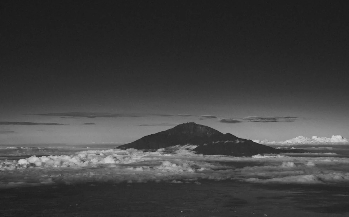
Mount Kilimanjaro is not merely a mountain; it is a colossal monument to the raw power of volcanic activity and the resilience of the human spirit. Rising 5,895 metres above the Tanzanian plains, it holds the dual distinction of being the highest peak on the African continent and the tallest free-standing mountain on Earth. This dormant stratovolcano, located within the Kilimanjaro National Park, offers one of the most accessible high-altitude adventures in the world, requiring no technical mountaineering skills or specialised climbing equipment. However, its accessibility should never be mistaken for ease. The journey to the summit, Uhuru Peak, is a gruelling test of physical endurance and mental fortitude, primarily due to the extreme altitude and the rapid transition through five distinct ecological zones.
The trek spans approximately 56.0 kilometres (depending on the chosen route) and involves a staggering elevation gain of 4,900 metres from the trailhead to the summit. Over the course of 6 to 9 days, walkers transition from the humid, lush rainforests of the lower slopes to the heather and moorland zones, through the stark, lunar-like alpine deserts, and finally into the arctic summit zone where ancient glaciers still cling to the crater rim. It is a journey that traverses the equivalent of a trip from the equator to the North Pole in less than a week. For those who reach the top, the reward is a sunrise above the clouds, looking out over the vast African savannah—a moment of profound clarity and achievement that remains etched in the memory forever.
Mount Kilimanjaro is a geological marvel consisting of three distinct volcanic cones: Kibo, Mawenzi, and Shira. While Mawenzi and Shira are extinct, Kibo—the highest point—is dormant and could theoretically erupt again, though its last major activity occurred over 200,000 years ago. The mountain's sheer scale creates its own weather systems, and the trek to the summit is defined by the dramatic shift in these environments. This "climatic world tour" is the defining characteristic of the Kilimanjaro experience, offering a variety of landscapes that few other trails can match.
The journey begins in the Cultivation Zone (800 m – 1,800 m), where the fertile volcanic soil supports lush coffee and banana plantations tended by the local Chagga people. As you enter the National Park, you transition into the Rainforest Zone (1,800 m – 2,800 m). This is a world of emerald green, characterised by high humidity, ancient trees draped in moss, and the occasional sighting of blue monkeys or black-and-white colobus monkeys. The air is thick and fragrant, and the trails are often damp and shrouded in mist.
Emerging from the forest, you enter the Heather and Moorland Zone (2,800 m – 4,000 m). Here, the canopy disappears, replaced by giant heathers, proteas, and the iconic giant lobelias and groundsels (Dendrosenecio kilimanjari), which look like something from a prehistoric era. The views begin to open up, revealing the jagged peaks of Mawenzi and the snow-capped dome of Kibo. Above 4,000 metres, the Alpine Desert Zone takes over. This is a harsh, arid landscape of volcanic rock and scree, where temperatures fluctuate wildly between scorching daytime sun and freezing night-time winds. Very little survives here, creating a stark, beautiful isolation.
Finally, the Arctic Zone (above 5,000 m) is the realm of ice and stone. The final ascent to the crater rim is a slow, rhythmic struggle against thinning oxygen. At the summit, the Rebmann and Furtwängler Glaciers provide a stunning, if shrinking, reminder of the mountain's icy crown. The physical challenge of Kilimanjaro is significant, but the logistical support provided by Tanzanian guides, porters, and cooks makes the journey possible for fit, determined walkers. It is a communal effort, where the phrase "Pole Pole" (Swahili for "slowly, slowly") becomes a mantra for survival and success.
The history of Mount Kilimanjaro is a blend of indigenous legend and colonial exploration. For centuries, the mountain has been a sacred site for the Chagga people who live on its lower slopes. They called the mountain "Kilemakyalo," which translates roughly to "that which is impossible to conquer" or "the mountain of caravans." To the Chagga, the mountain was a source of water, fertility, and spiritual power. Early European accounts of a snow-capped mountain on the equator were initially dismissed as hallucinations or myths, as the scientific community of the 19th century found the concept of permanent ice in East Africa impossible to believe.
The first recorded European to see the mountain was the German missionary Johannes Rebmann in 1848. However, it took several decades before a successful ascent was documented. In 1889, German geology professor Hans Meyer, Austrian mountaineer Ludwig Purtscheller, and local scout Yohani Kinyala Lauwo reached the summit of Kibo. Lauwo, a resident of Marangu, is a legendary figure in Kilimanjaro history; he reportedly lived to be 125 years old and provided invaluable local knowledge that made the first ascent possible. Today, the Lauwo family remains involved in the mountain's trekking industry, bridging the gap between the pioneering past and the modern era of tourism.
In the 20th century, Kilimanjaro became a symbol of Tanzanian national identity. When Tanganyika gained independence from Britain in 1961, a "torch of freedom" (Uhuru Torch) was carried to the summit to signify the birth of the new nation. The highest point was subsequently renamed Uhuru Peak—"Uhuru" being the Swahili word for "Freedom." Today, the mountain is a UNESCO World Heritage site, recognised for its unique ecosystems and its status as a global icon of adventure. The trekking industry is a vital part of the local economy in Moshi and Arusha, supporting thousands of families through the work of guides, porters, and park rangers.
Want more background? Read extended notes on history and cultural context → Learn more
Mount Kilimanjaro's proximity to the equator means it does not experience traditional four-season weather. Instead, the climate is dictated by wet and dry seasons. Choosing the right time to climb is crucial for both safety and the likelihood of reaching the summit.
January to March (The Warm Dry Season): This is often considered the best time to climb. The weather is generally clear, and the temperatures are slightly warmer than the mid-year dry season. The views are spectacular, and the trails are relatively dry. However, this is also a popular time, so the main routes can be busy.
June to October (The Cool Dry Season): This is the longest dry window and coincides with the northern hemisphere summer holidays. The weather is very stable, though it is noticeably colder than the January–March period, especially at night. This is the peak season for Kilimanjaro, and the mountain can feel crowded, particularly on the Machame and Marangu routes.
April to May (The Long Rains): This is the primary wet season. Climbing during this time is not recommended for most trekkers. The rainforest becomes a mud bath, visibility is often zero, and the summit is frequently lashed by heavy snow and high winds. While some experienced hikers enjoy the solitude, the risk of failure and discomfort is significantly higher.
November to December (The Short Rains): This period sees afternoon thunderstorms and occasional heavy rain. While it is possible to climb, you should be prepared for wet gear and slippery trails. The Rongai route, which approaches from the north, is often drier during this time as it sits in the rain shadow of the mountain.
Regardless of the season, weather on Kilimanjaro is notoriously unpredictable. You can experience four seasons in a single day. Temperatures at the trailhead might be 30°C, while the summit can drop to -20°C with wind chill. Proper layering and high-quality waterproof gear are essential year-round.
Day 1: Machame Gate to Machame Camp
Day 2: Machame Camp to Shira 2 Camp
Day 3: Shira 2 Camp to Barranco Camp via Lava Tower
Day 4: Barranco Camp to Karanga Camp
Day 5: Karanga Camp to Barafu Camp
Day 6: Barafu Camp to Uhuru Peak and down to Mweka Camp
Day 7: Mweka Camp to Mweka Gate
Important Notes:
Planning a Kilimanjaro trek requires several months of lead time. Unlike many other Great Walks, you cannot legally climb Kilimanjaro independently; you must be accompanied by a licensed guide and a registered trekking company. This means your primary planning task is selecting a reputable operator. Look for companies that are members of the Kilimanjaro Porters Assistance Project (KPAP), which ensures fair wages and ethical treatment of staff.
Physical preparation is vital. While you don't need to be an elite athlete, you should have a high level of cardiovascular fitness. Training should focus on long-distance hiking with a weighted pack, ideally including some hill or stair work to prepare your legs for the 4,900-metre elevation gain and the punishing descent. Mental preparation is equally important; the summit night is a test of willpower as much as physical strength.
Moshi is the traditional base for Kilimanjaro treks. It is a vibrant town with a range of accommodation from basic hostels to comfortable hotels. Most operators include airport transfers from Kilimanjaro International Airport (JRO) and pre/post-trek accommodation in their packages. Ensure your travel insurance specifically covers "high-altitude trekking up to 6,000 metres" and includes emergency helicopter evacuation.
Accommodation on Kilimanjaro depends entirely on the route you choose. There are two primary styles: camping and huts.
Camping (Machame, Lemosho, Rongai, Northern Circuit):
Huts (Marangu Route only):
Facilities Provided: All meals are prepared by a dedicated mountain cook. Water is collected from mountain streams, boiled, and filtered for your consumption. There is no electricity for charging devices at the camps, so portable power banks are essential.
Access to Kilimanjaro is strictly controlled by the Kilimanjaro National Park (KINAPA). You cannot simply show up and start walking. Permits are issued only to registered trekking companies, and the cost of these permits makes up a significant portion of your total trek price. Unlike the Milford Track, there is no "lottery" or single booking day, but you must book through an operator who handles the bureaucracy for you.
Permit Costs and Fees:
Booking Process: You should book your trek at least 3 to 6 months in advance, especially if you plan to climb during the peak dry seasons. Your operator will require a copy of your passport and your arrival details to secure the permits. Once you arrive at the park gate (e.g., Machame Gate or Marangu Gate), you must sign in personally with the park rangers. This registration is vital for safety and tracking the number of people on the mountain.
Tipping Culture: While not a "permit" in the legal sense, tipping is a mandatory social contract on Kilimanjaro. The trekking industry relies on tips to provide a living wage for the crew. Expect to tip approximately US$250–$350 per climber for a 7-day trek, which is distributed among the lead guide, assistant guides, cook, and porters. This should be factored into your total budget from the beginning.

Detailed route notes, maps, logistics & tips for the Mount Kilimanjaro (PDF).

Precisely traced GPX for the Mount Kilimanjaro, ready for your GPS or favourite mapping app.
Tanzania offers some of the world's most iconic travel experiences. Most trekkers combine their Kilimanjaro climb with one of the following:
Altitude Sickness (AMS): The single greatest risk on Kilimanjaro is Acute Mountain Sickness. Because the mountain rises so steeply, many trekkers ascend too quickly for their bodies to adapt to the decreasing oxygen levels. Symptoms include headache, nausea, dizziness, and loss of appetite. The key to prevention is "Pole Pole" (slowly, slowly) and choosing a longer itinerary. More severe forms, such as HAPE (High Altitude Pulmonary Edema) and HACE (High Altitude Cerebral Edema), are life-threatening and require immediate descent.
Health Monitoring: Reputable guides will perform health checks twice daily using a pulse oximeter to measure your blood oxygen saturation and heart rate. They are trained to recognise the early signs of altitude sickness and will make the decision to send a climber down if their health is at risk. Never hide your symptoms from your guide; honesty is essential for your safety.
Hypothermia and Exposure: Even in the dry season, temperatures on the summit can be lethal if you are not properly dressed. Wet clothing from rain or sweat can lead to rapid heat loss. The summit push is particularly dangerous as you are moving slowly in extreme cold for many hours. High-quality layers and staying dry are your best defences.
Evacuation Procedures: In the event of an emergency, the primary method of evacuation is a "Kilimanjaro Stretcher"—a single-wheeled metal gurney operated by porters. Helicopter evacuation is available but is highly dependent on weather conditions and visibility. Ensure your insurance company has a direct relationship with local evacuation providers like AMREF Flying Doctors.
Water Safety: Never drink untreated water from mountain streams. While the water looks clear, it can carry parasites. Your crew will boil water for you, but using additional purification tablets is a wise precaution for those with sensitive stomachs.
The Barranco Wall: Often a highlight for many trekkers, this 257-metre rock face requires a bit of "scrambling." It is not technical climbing, but it does involve using your hands for balance. The "Kissing Rock" is a narrow section where you must hug the rock face to pass. The views from the top of the wall back down into the valley are some of the best on the Machame route.
Lava Tower: A 90-metre tall volcanic plug that stands at 4,600 metres. It is a stark reminder of the mountain's volcanic past. Most routes pass by its base for acclimatisation. For the very brave (and those not suffering from vertigo), it is sometimes possible to scramble to the top, though most guides discourage this to save energy for the summit.
The Ash Pit: For those with extra energy and a 9-day itinerary, a hike into the Kibo Crater to see the Ash Pit is possible. This is the most recent volcanic vent and is a perfectly circular, 120-metre deep pit within the crater. It is a surreal, silent place that feels like the very centre of the earth.
Shira Plateau: One of the largest high-altitude plateaus in the world, the Shira Plateau is a remnants of the mountain's first volcanic cone. Walking across this vast, open space provides a sense of the mountain's true scale and offers incredible views of the sunset above the clouds.
The Glaciers: The Rebmann, Decken, and Furtwängler Glaciers are the remnants of the ice cap that once covered the entire summit. They are retreating rapidly and are estimated to disappear within the next few decades. Seeing these massive walls of blue ice on the equator is a haunting and beautiful experience.
Kilimanjaro is a fragile ecosystem under immense pressure from the thousands of people who climb it every year. As a UNESCO World Heritage site, it is our collective responsibility to ensure its preservation. The "Leave No Trace" principles are strictly enforced by park rangers and should be followed by every trekker.
Environmental Responsibility:
Social Responsibility: Ethical trekking is a core part of Leave No Trace on Kilimanjaro. This means supporting the porters who make your climb possible. Ensure your operator follows the Kilimanjaro Porters Assistance Project (KPAP) guidelines. This includes providing porters with three meals a day, proper sleeping gear, a 15 kg weight limit for their loads, and fair wages. A "Leave No Trace" trekker respects the people as much as the land.
The mountain is a sacred place for the local community. Treat the guides and porters with the respect they deserve as professionals. Your journey is made possible by their incredible strength and knowledge.