Mount Kaputar Summit Track
The Mount Kaputar Summit Track is a rewarding day walk located within Mount Kaputar National Park, in New South Wales, Australia. This trail offers a moderate challenge, leading hikers to the summit of Mount Kaputar, the park's highest peak. The journey is characterised by its diverse vegetation, from dry sclerophyll forests to more temperate rainforest pockets, and culminates in spectacular panoramic views of the surrounding landscape. It's a popular choice for those seeking a substantial day hike with a significant elevation gain and a rewarding vista at its conclusion.
- Category: Day Walk
- Distance: 11.5 km (return)
- Elevation Gain: 550 m
- Duration: 4–5 hours
- Difficulty: Moderate
- Best Time: Autumn and Spring (March–May and September–November)
- Closest City: Narrabri, NSW
- Trailhead Access: Via Kaputar Road, approximately 57 km east of Narrabri.
Overview
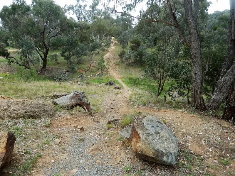
The Mount Kaputar Summit Track is a well-defined, yet challenging, day walk that ascends to the highest point in Mount Kaputar National Park. The trail begins at a modest elevation and steadily climbs, offering a gradual but persistent workout. As you ascend, the vegetation changes, reflecting the varying microclimates and altitudes within the park. Initially, you'll traverse dry sclerophyll forests, typical of the lower slopes, characterised by eucalyptus trees and hardy undergrowth. As the elevation increases, the environment transitions, with pockets of more temperate rainforest appearing, featuring ferns and a denser canopy. This ecological diversity makes the walk visually interesting, with distinct changes in flora and fauna as you climb.
The track itself is primarily a well-maintained path, though it can be rocky and uneven in places, requiring sturdy footwear. The 550 metres of elevation gain are distributed over the 11.5 km distance, meaning the climb is consistent rather than overwhelmingly steep in any single section, but it demands good cardiovascular fitness and leg strength. The final approach to the summit involves a series of steps and rocky outcrops, adding a touch of adventure to the ascent.
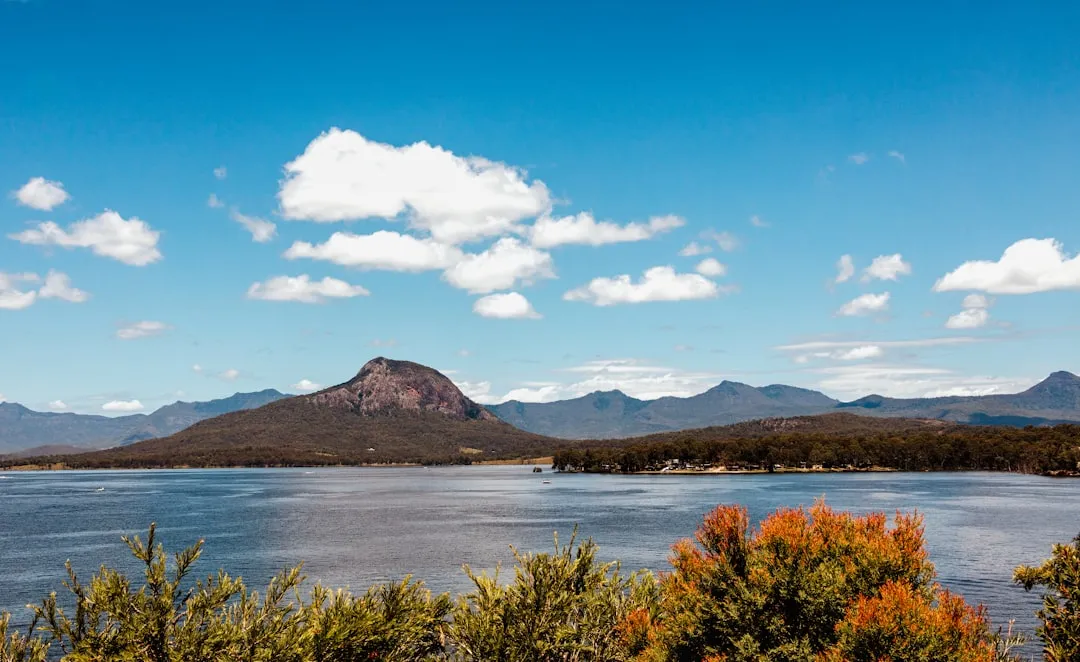
Upon reaching the summit, the reward is a breathtaking 360-degree panorama. On a clear day, you can see for vast distances across the plains of the Nandewar Range and beyond. The views encompass the rolling hills, distant mountain ranges, and the agricultural landscape of the surrounding region. This expansive vista makes the effort of the climb entirely worthwhile. The summit area is often exposed to the elements, so be prepared for wind and changing temperatures, even on a pleasant day.
The Mount Kaputar Summit Track is a journey that combines physical exertion with natural beauty, offering a tangible sense of accomplishment and a profound connection to the Australian landscape. It is an ideal destination for hikers looking for a substantial day trip that showcases the varied environments of the region.
History and Cultural Context
Mount Kaputar and its surrounding ranges hold deep cultural significance for the Traditional Owners, the Gomeroi people. For millennia, this area has been a place of importance, providing resources, shelter, and spiritual connection. The mountains and waterways were integral to their way of life, with knowledge of the land passed down through generations. The name "Kaputar" itself is believed to derive from Gomeroi language, reflecting this enduring connection.
European exploration and settlement in the region began in the mid-19th century. The rugged terrain of the Nandewar Range presented challenges for early settlers and surveyors. The establishment of Mount Kaputar National Park in the 20th century was a crucial step in preserving the unique natural and cultural heritage of the area. The park was gazetted to protect its diverse ecosystems, including the rare rainforest pockets, the unique volcanic geology, and the significant Aboriginal heritage sites.
The development of walking tracks, including the Summit Track, facilitated public access and appreciation for the park's natural beauty. These tracks were often built with a focus on providing access to key viewpoints and natural features, allowing visitors to experience the landscape that has been cherished by Indigenous peoples for thousands of years. The park continues to be managed in collaboration with the Gomeroi people, ensuring that cultural values are respected and integrated into conservation efforts.
Seasonal Highlights and Weather Reality
The Mount Kaputar Summit Track is accessible year-round, but certain seasons offer more pleasant conditions for hiking. The best times to undertake this walk are during Autumn (March to May) and Spring (September to November).
Autumn (March–May): This period is ideal due to mild temperatures and lower humidity. The days are generally sunny and clear, offering excellent visibility from the summit. The cooler weather makes the 550-metre ascent more comfortable, and the risk of extreme heat is significantly reduced. The surrounding landscape may also begin to show subtle changes in colour as the seasons transition.
Spring (September–November): Spring brings warmer temperatures and the park comes alive with wildflowers. While it can still be warm, it is generally more pleasant than the peak of summer. The increased daylight hours are also beneficial for longer hikes. However, spring can also bring occasional thunderstorms, so checking the weather forecast is essential.
Summer (December–February): Summers in this region can be very hot, with temperatures frequently exceeding 30°C, and sometimes reaching over 40°C. The exposed nature of the summit track means there is little shade for much of the ascent, making hiking during the hottest parts of the day potentially dangerous. If hiking in summer, it is strongly advised to start very early in the morning, carry ample water, and be prepared for extreme heat. The summit can also be subject to sudden, intense thunderstorms during summer afternoons.
Winter (June–August): Winters are generally mild, with cooler temperatures and occasional frost. Daytime temperatures are usually pleasant for hiking, though mornings and evenings can be quite cold. Snowfall is rare at the summit but not impossible, and can add a beautiful, albeit challenging, dimension to the walk. Visibility can be reduced by fog or low cloud during winter months.
Weather Considerations: Regardless of the season, weather in national parks can change rapidly. The summit of Mount Kaputar is exposed and can be significantly cooler and windier than the surrounding areas. Always check the forecast before you go and be prepared for a range of conditions, including rain, wind, and temperature fluctuations.
Recommended Itinerary
Mount Kaputar Summit Track - Day Walk Itinerary
Early Morning (Approx. 7:00 AM - 8:00 AM): Departure from Narrabri
- Depart from Narrabri, heading east on Kaputar Road.
- The drive to the trailhead takes approximately 50–60 minutes.
- Ensure you have sufficient fuel, as services are limited once you leave Narrabri.
- This early start allows for a comfortable hike with ample daylight and avoids the worst of the midday heat, especially during warmer months.
Morning (Approx. 8:00 AM - 8:30 AM): Arrival at Trailhead and Preparation
- Arrive at the Mount Kaputar Summit Track trailhead.
- Locate the parking area and the start of the track.
- Take time to prepare your gear: adjust backpack, apply sunscreen, and ensure you have enough water.
- Briefly review the trail map or signage if available.
- GPS Coordinates for trailhead: -30.2453, 150.1582
Morning to Midday (Approx. 8:30 AM - 12:30 PM): Ascent to the Summit
- Begin the 11.5 km (return) hike.
- The initial section of the track is relatively gentle, passing through dry sclerophyll forest.
- As you gain elevation, the terrain becomes rockier and the gradient increases.
- Observe the changing vegetation, transitioning from dry forest to more temperate zones with ferns and denser trees.
- The track is generally well-marked, but always be aware of your surroundings.
- Key waypoints may include various lookouts or distinct rock formations.
- The total elevation gain is approximately 550 metres.
- The estimated time for the ascent is 2–2.5 hours, depending on fitness and pace.
Midday (Approx. 12:30 PM - 1:30 PM): Summit Exploration and Lunch
- Reach the summit of Mount Kaputar.
- Spend time enjoying the panoramic 360-degree views of the surrounding landscape, including the Nandewar Range.
- Identify prominent landmarks visible from the summit.
- Find a sheltered spot to enjoy your packed lunch and rehydrate.
- Be aware of wind and temperature changes at the exposed summit.
Afternoon (Approx. 1:30 PM - 3:30 PM): Descent to Trailhead
- Begin the descent back to the trailhead.
- The descent can be hard on the knees, so take your time and use trekking poles if you have them.
- Continue to observe the changing flora as you return to lower altitudes.
- The estimated time for the descent is 1.5–2 hours.
Late Afternoon (Approx. 3:30 PM onwards): Return Journey
- Arrive back at the trailhead.
- Pack up your gear and begin the drive back to Narrabri.
- Consider stopping at a local café in Narrabri to celebrate your hike.
Important Notes:
- This is a day walk; no overnight accommodation is required or available on the track.
- Carry sufficient water (at least 2-3 litres per person) as there are no water sources along the track.
- Wear sturdy, closed-toe hiking boots.
- Dress in layers, as temperatures can vary significantly between the base and the summit.
- Always check the weather forecast before you depart.
- Inform someone of your hiking plans, including your expected return time.
Planning and Bookings
Book Your Trip
Everything you need to plan your journey
Accommodation
Find places to stay near Narrabri
Flights
Search flights to Narrabri
Essential Preparation
The Mount Kaputar Summit Track is a day walk, meaning no overnight accommodation bookings are required. However, thorough preparation is still essential for a safe and enjoyable experience. The closest major town and logistical hub is Narrabri, located approximately 57 kilometres west of the national park entrance. Narrabri offers a range of services including accommodation (hotels, motels, caravan parks), supermarkets for purchasing supplies, outdoor gear shops, and fuel stations. It is highly recommended to stock up on all necessary food, water, and any last-minute gear in Narrabri before heading into the park.
Access to the trailhead is via Kaputar Road, which is sealed but can be narrow and winding in sections. It is advisable to check the road conditions with NSW National Parks and Wildlife Service (NPWS) prior to your visit, especially after heavy rain, as sections can be prone to minor washouts or closures. Ensure your vehicle is in good condition, as the drive involves a significant distance on a mountain road. Mobile phone reception is unreliable within the park, so download offline maps and inform someone of your itinerary and expected return time.
Trail Accommodation
This is a day hike requiring no overnight accommodation.
Required Gear
- Sturdy Hiking Boots: Waterproof and with good ankle support are essential due to the rocky and uneven terrain. Ensure they are well broken-in to prevent blisters.
- Backpack: A comfortable day pack (20-30 litres) to carry essentials.
- Navigation: A map of Mount Kaputar National Park, a compass, and/or a GPS device or smartphone with offline maps downloaded. While the track is generally well-marked, it's crucial to be prepared.
- First-Aid Kit: Comprehensive kit including bandages, antiseptic wipes, pain relievers, blister treatment, and any personal medications.
- Sun Protection: High SPF sunscreen, wide-brimmed hat, and sunglasses. The summit is exposed, and the sun can be intense.
- Insect Repellent: Particularly useful during warmer months.
- Head Torch: With spare batteries, in case your hike extends longer than anticipated or for early morning starts.
- Trekking Poles (Optional): Can be beneficial for stability on ascents and descents, especially on rocky sections.
What to Bring
- Water: Carry a minimum of 2-3 litres of water per person. There are no reliable water sources along the Summit Track.
- Food: High-energy snacks and a packed lunch. Consider items like sandwiches, fruit, nuts, energy bars, and trail mix.
- Clothing: Wear moisture-wicking base layers. Bring a warm fleece or jacket as a mid-layer, as temperatures can drop significantly at the summit, especially in cooler months or if the weather changes. A waterproof and windproof outer shell is also recommended.
- Emergency Shelter: A lightweight emergency blanket or bivvy bag can be a lifesaver in unexpected situations.
- Communication Device: A fully charged mobile phone (though reception is limited) and consider a personal locator beacon (PLB) for remote areas.
- Toilet Paper and Hand Sanitiser: For personal hygiene.
- Camera: To capture the stunning views.
Permits
No specific permits are required for day hiking on the Mount Kaputar Summit Track. Entry into Mount Kaputar National Park is generally free for day visitors. However, it is always advisable to check the official NSW National Parks and Wildlife Service (NPWS) website for any temporary restrictions, alerts, or changes to park access, particularly concerning road conditions or fire bans.
Registration: While not mandatory for day hikers, it is recommended to register your visit at the park's visitor centre or a designated registration point if available. This helps park authorities monitor visitor numbers and provides a record in case of emergencies. If there is no formal visitor centre or registration point at the trailhead, informing a friend or family member of your hiking plans and expected return time is a crucial safety measure.
Park Fees: For day use, there are typically no entry fees for Mount Kaputar National Park. However, if you plan to stay overnight in designated camping areas within the park (which are separate from the Summit Track itself), camping fees may apply. Always verify current fee structures on the NPWS website.
Fire Restrictions: Be aware of any fire bans that may be in place, especially during warmer months. Campfires are generally prohibited in most areas of national parks, and specific rules apply to BBQs or cooking stoves. Always adhere to fire regulations to prevent bushfires.
Other Activities in the Area
Mount Kaputar National Park and its surrounds offer a variety of activities for visitors:
- Other Walking Tracks: The park features several other walking trails catering to different fitness levels and interests. These include shorter walks to scenic lookouts like the Governor's Leap Lookout, and longer, more challenging routes.
- Picnicking and Barbecuing: Designated picnic areas with facilities are available within the park, offering pleasant spots to relax and enjoy a meal amidst nature.
- Wildlife Spotting: Mount Kaputar National Park is home to a diverse range of native Australian wildlife, including kangaroos, wallabies, various bird species (such as the endangered Regent Honeyeater), and reptiles. Early morning and late afternoon are often the best times for sightings.
- Scenic Drives: The drive along Kaputar Road itself is scenic, offering changing landscapes and access to various points of interest within the park.
- Photography: The park provides numerous opportunities for landscape and nature photography, from the expansive summit views to the intricate details of the rainforest flora.
- Stargazing: Due to its remote location and minimal light pollution, Mount Kaputar offers excellent conditions for stargazing on clear nights.
- Visiting Narrabri: The nearby town of Narrabri offers additional attractions, including the Australia Telescope Compact Array (a major radio astronomy facility), the Narrabri Museum, and local shops and eateries.
Safety and Conditions
Weather Preparedness: The most critical safety aspect for the Mount Kaputar Summit Track is weather. Temperatures can fluctuate dramatically between the base and the summit, and conditions can change rapidly. Always check the Bureau of Meteorology (BOM) forecast for the Mount Kaputar region before you depart. Be prepared for strong winds, rain, and significant temperature drops, even on seemingly warm days. If severe weather is forecast, postpone your hike.
Hydration and Nutrition: Carry more water than you think you will need, especially during warmer months. Dehydration is a serious risk. Pack high-energy food to maintain your energy levels throughout the 4-5 hour hike.
Trail Conditions: The track is generally well-maintained but can be rocky, uneven, and steep in places. Wear appropriate footwear with good grip and ankle support. Be mindful of loose rocks and slippery surfaces, particularly after rain.
Wildlife Encounters: While generally shy, native wildlife such as snakes, kangaroos, and spiders inhabit the park. Maintain a safe distance, do not feed any animals, and be aware of your surroundings, especially when stepping over logs or rocks. If you encounter a snake, remain calm and give it plenty of space to move away.
Communication: Mobile phone reception is unreliable within Mount Kaputar National Park. Inform a reliable person of your hiking plans, including your intended route, departure time, and expected return time. Consider carrying a Personal Locator Beacon (PLB) for added safety in remote areas.
Bushfire Risk: Mount Kaputar National Park can be susceptible to bushfires, particularly during dry periods. Always check for fire bans and park closures before your visit. If a fire is detected, follow the advice of park authorities and emergency services.
First Aid: Carry a comprehensive first-aid kit and know how to use it. Blisters, sprains, and minor cuts are common hiking injuries. For serious emergencies, call Triple Zero (000) if you have reception, or activate your PLB.
Side Trips and Points of Interest
Governor's Leap Lookout: Located a short distance from the Summit Track trailhead, this lookout offers impressive views over the surrounding valleys and plains. It's an excellent spot for a brief stop to appreciate the scale of the landscape before or after your summit attempt. The viewpoint provides a different perspective to the summit panorama, showcasing the lower elevations and the transition zones of the park.
The Dawsons Spring Area: This area, often a starting point for various walks, features picnic facilities and access to different sections of the park. While not a direct side trip from the Summit Track, it's a key hub within the park and worth noting for its amenities and connection to other trails.
Unique Flora and Fauna: As you ascend the Summit Track, pay attention to the changing vegetation. You'll transition from dry, hardy eucalyptus forests to pockets of more temperate rainforest with ferns and mosses. Keep an eye out for native birds, kangaroos, and other wildlife that inhabit these diverse ecosystems. The park is known for its biodiversity, and even a short walk can reveal fascinating natural details.
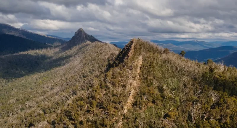
Volcanic Geology: Mount Kaputar is part of the Nandewar Range, an ancient volcanic complex. While the Summit Track doesn't delve deeply into geological explanations, the very formation of the mountain is a point of interest. The summit itself is a remnant of this volcanic past, offering a tangible connection to the region's geological history.
Leave No Trace
Practising Leave No Trace principles is crucial for preserving the natural beauty and ecological integrity of Mount Kaputar National Park. As a day walk, the impact can be minimised by adhering to these guidelines:
- Plan Ahead and Prepare: Research the trail, understand its conditions, and be prepared for the weather. This includes carrying adequate supplies and knowing the park's regulations.
- Travel and Camp on Durable Surfaces: Stick to the marked trail at all times. Avoid walking on vegetation, especially fragile plants and mosses, which can take a long time to recover. The summit area, while rocky, should also be treated with care to avoid disturbing any delicate alpine flora.
- Dispose of Waste Properly: Pack out everything you pack in. This includes all food scraps, wrappers, and any other litter. Use designated bins if available at the trailhead or picnic areas, but never leave waste behind.
- Leave What You Find: Do not remove any natural objects, such as rocks, plants, or flowers. Take only photographs and memories.
- Minimise Campfire Impacts: Campfires are generally not permitted on day walks, and if using designated picnic areas with BBQs, ensure they are used responsibly and extinguished properly. Check for fire bans.
- Respect Wildlife: Observe wildlife from a distance. Never feed animals, as this can disrupt their natural behaviours and diets, and can be harmful to their health.
- Be Considerate of Other Visitors: Keep noise levels down, especially on the summit, to allow everyone to enjoy the natural environment. Yield to uphill walkers when possible.
By following these principles, you help ensure that Mount Kaputar National Park remains a pristine and enjoyable destination for all visitors, both now and in the future.