Mount Fitz Roy Trek (Laguna de los Tres) - The Crown Jewel of Patagonia
The Mount Fitz Roy Trek, culminating at the breathtaking Laguna de los Tres, is arguably the most iconic day hike in South America. Located within the northern sector of Los Glaciares National Park in Argentina's Santa Cruz Province, this trail offers an unparalleled window into the raw, vertical world of the Southern Patagonian Ice Field. The journey leads hikers through ancient southern beech forests, across crystalline glacial streams, and up a challenging moraine to the base of the legendary Monte Fitz Roy (also known as Cerro Chaltén). Standing at 3,405 metres, the granite massif's jagged silhouette serves as the inspiration for the Patagonia clothing logo and remains a holy grail for mountaineers and trekkers alike. This is a landscape of extremes, where the silence of the sub-antarctic forest meets the roaring winds of the high Andes, providing a sensory experience that defines the spirit of Patagonian exploration.
- Distance: 21.4 km (return from El Chaltén) or 20.5 km (point-to-point from El Pilar)
- Duration: 8–10 hours
- Season: October to April (Peak season: December to February)
- Elevation Gain: 1,200 metres total ascent
- Highest Point: Laguna de los Tres (1,170 metres)
- Difficulty: Challenging (due to the final 400-metre vertical scramble)
- Trailhead: El Chaltén village or Hostería El Pilar
Overview
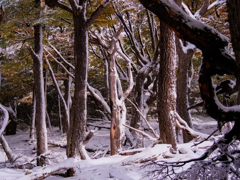
The trek to Laguna de los Tres is the definitive Patagonian hiking experience. While many trails in the region offer glimpses of the great granite spires, this route places you directly at their feet. The "Chaltén" massif, named by the indigenous Tehuelche people meaning "smoking mountain" (due to the clouds that frequently swirl around its peak), dominates the horizon from the moment you step onto the trail. The hike is a masterclass in ecological transition, moving from the arid steppe-like outskirts of the village into lush, moss-draped Nothofagus (southern beech) forests, before finally emerging into the stark, high-alpine environment of rock and ice.
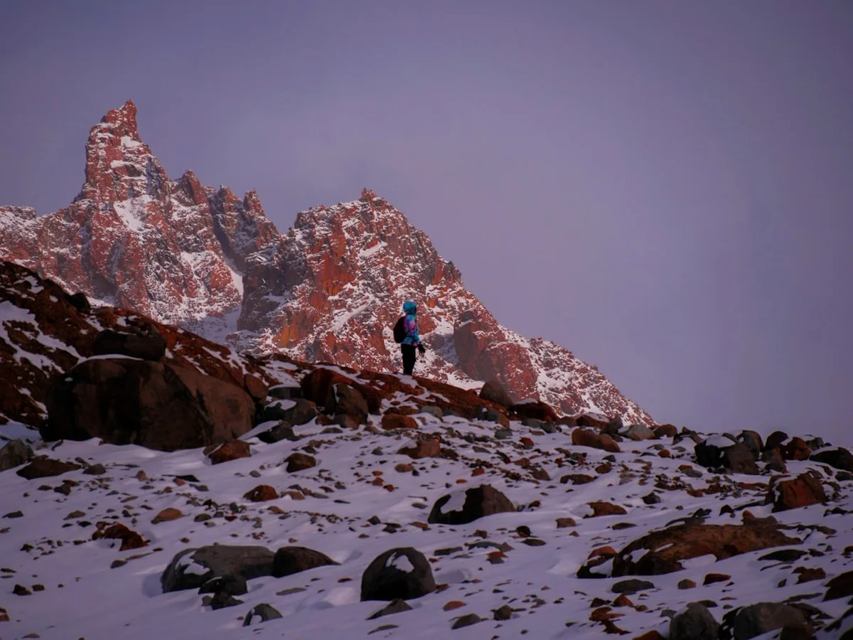
The trail is generally well-maintained and clearly marked, making it accessible to fit hikers without the need for a guide. However, its "challenging" rating is well-earned. While the first three-quarters of the hike involve gentle undulations and manageable gradients, the final kilometre is a relentless, steep ascent over loose rock and scree. This section alone gains 400 metres of elevation and requires steady footing and physical resilience. The reward at the summit is a panoramic view that defies description: the turquoise waters of Laguna de los Tres sit in the foreground, framed by the sheer 1,500-metre vertical walls of Fitz Roy, flanked by the needle-like spires of Aguja Poincenot and Aguja Mermoz.
What sets this trek apart is the sheer scale of the landscape. You aren't just looking at a mountain; you are witnessing the intersection of the world's third-largest continental ice mass and the rugged eastern edge of the Andes. The weather here is a primary character in the story—Patagonian winds can reach speeds that make standing difficult, and clear skies can vanish in minutes. To hike here is to accept a contract with nature: you provide the effort, and the mountains provide a spectacle that is both humbling and life-affirming. Whether you choose the traditional out-and-back route from the town centre or the more scenic point-to-point route starting from El Pilar, the Laguna de los Tres trek remains the gold standard for day hiking in Argentina.
History and Cultural Context
The history of the Mount Fitz Roy region is a tapestry of indigenous heritage, colonial exploration, and legendary mountaineering feats. For centuries, the Aonikenk (Tehuelche) people inhabited these valleys. They held the mountain in deep spiritual regard, naming it Chaltén. They believed the clouds surrounding the summit were smoke, leading to the misconception that it was a volcano. To the Aonikenk, the mountain was a landmark of permanence in a nomadic existence, a sacred sentinel of the southern plains.
European contact brought a change in nomenclature. In 1877, the Argentine explorer Francisco Pascasio Moreno (Perito Moreno) sighted the peak. Although he did not climb it, he renamed it Mount Fitz Roy in honour of Robert FitzRoy, the captain of the HMS Beagle who had surveyed the Patagonian coast in the 1830s with Charles Darwin. This naming was part of a broader effort to map and claim the territory for Argentina during a period of border tensions with Chile. The first European settler in the immediate area was Andreas Madsen, a Danish explorer who arrived in the early 1900s and established a farm near the base of the mountains, living a life of incredible hardship and solitude that he later documented in his memoirs.
The mountaineering history of Fitz Roy is equally dramatic. The peak remained unclimbed until 1952, when a French expedition led by Lionel Terray and Guido Magnone successfully reached the summit. This was a monumental achievement in the climbing world, as Fitz Roy is considered technically more difficult than Mount Everest due to its sheer granite faces and notoriously atrocious weather. Since then, the area has become a global hub for alpinists. The village of El Chaltén itself was only founded in 1985, making it one of Argentina's youngest towns. It was established primarily to secure the border in a disputed zone, but it quickly evolved into the "National Capital of Trekking," serving as the gateway for the thousands of hikers who now visit Los Glaciares National Park every year. Walking these trails today, one follows in the footsteps of ancient nomads, boundary-mapping explorers, and the world's most daring climbers.
Want more background? Read extended notes on history and cultural context → Learn more
Seasonal Highlights and Weather Reality
Timing is everything in Patagonia. The trekking season officially runs from October to April, coinciding with the Southern Hemisphere's spring, summer, and early autumn. Outside of these months, the trail is often buried in deep snow, daylight hours are minimal, and the village of El Chaltén enters a period of semi-hibernation with many services closed.
Spring (October to November): This is a season of awakening. The forests begin to bud with fresh green leaves, and the red flowers of the Notro (Chilean Firebush) provide splashes of brilliant colour against the grey granite. While the weather is unpredictable and snow may still linger on the higher sections of the trail, the crowds are significantly thinner. The winds, however, can be particularly fierce during the spring transition.
Summer (December to February): This is the peak season. Expect long daylight hours (the sun sets as late as 10:00 PM), warmer temperatures (averaging 10°C to 18°C), and the best chance of clear views of the Fitz Roy summit. However, this is also when the trail is most crowded. The final ascent to the lagoon can feel like a procession on particularly busy days. Booking accommodation in El Chaltén months in advance is essential during this window.
Autumn (March to April): Many seasoned hikers consider this the best time to visit. The Lenga and Ñire forests turn vibrant shades of orange, gold, and deep red, creating a spectacular contrast with the blue glacial lakes. The winds often die down in April, and the crisp, cool air provides excellent visibility. By late April, the first winter dustings of snow begin to appear on the lower slopes.
The Weather Reality: Regardless of the season, the "Patagonian Factor" must be respected. The region is famous for experiencing four seasons in a single day. High-velocity winds, known as "The Roaring Forties," can sweep across the plains, making hiking difficult and dropping the wind-chill temperature to near freezing even in mid-summer. Rain is common, and cloud cover can obscure the mountains for days at a time. Hikers must be prepared to be patient; sometimes the best views require waiting for a "window" of clear weather.
Recommended Itinerary
Laguna de los Tres: The El Pilar to El Chaltén Route
While many hikers do a simple out-and-back from the town, the superior way to experience this trek is the point-to-point route starting at Hostería El Pilar and finishing in El Chaltén. This avoids repeating scenery and offers a spectacular view of the Piedras Blancas Glacier.
Phase 1: Early Morning - The Trailhead Start
- Start: Hostería El Pilar (17 km north of El Chaltén)
- Time: 08:00 – 09:00
- Take a pre-booked shuttle or taxi from El Chaltén to El Pilar.
- The trail begins with a gentle climb through a private reserve before entering the National Park.
- Walk through dense beech forest alongside the Rio Blanco.
- The gradient is easy, allowing for a steady warm-up.
Phase 2: Mid-Morning - Glacier Views and Forest Paths
- Distance: 5 km from start
- Time: 09:00 – 11:00
- Reach the Mirador Glaciar Piedras Blancas. This viewpoint offers a stunning look at a hanging glacier spilling off the side of the Fitz Roy massif.
- Continue through the forest toward Campamento Poincenot.
- The trail is mostly flat here, crossing small wooden bridges over crystal-clear streams.
- Pass the Poincenot campsite, a popular spot for overnight trekkers.
Phase 3: Midday - The Vertical Challenge
- Distance: 1 km (The "Final Kilometre")
- Elevation Gain: 400 m
- Time: 11:30 – 13:00
- Cross the Rio Blanco bridge to reach the base of the final ascent.
- The terrain shifts dramatically to steep, loose rock and switchbacks.
- This is the most physically demanding part of the day. Take frequent breaks and stay hydrated.
- The path is well-marked but requires careful foot placement, especially in high winds.
Phase 4: Early Afternoon - The Summit and Laguna de los Tres
- Elevation: 1,170 m
- Time: 13:00 – 14:30
- Arrive at the crest of the moraine to see Laguna de los Tres and Mount Fitz Roy.
- Walk down to the shore of the turquoise lagoon.
- CRITICAL SIDE TRIP: Walk 5 minutes to the left (south) over a small ridge to see Laguna Sucia, a deep blue lake sitting hundreds of metres below.
- Enjoy lunch while taking in the most famous view in Patagonia.
Phase 5: Late Afternoon - The Descent to El Chaltén
- Distance: 10 km
- Time: 14:30 – 18:00
- Descend the steep moraine (use trekking poles to save your knees).
- Instead of heading back to El Pilar, follow the signs for "El Chaltén via Laguna Capri."
- Pass through open meadows with constant views of the Fitz Roy spires behind you.
- Stop at Mirador Laguna Capri for a final iconic photo of the lake and the mountain.
- The final 3 km is a steady descent into the northern end of El Chaltén village.
Important Notes:
- Total walking time is usually 8 to 10 hours depending on fitness and photo stops.
- The El Pilar shuttle must be booked the day before at any travel agency in town.
- There are no food or water facilities on the trail; you must be self-sufficient.
- The final ascent may be closed by park rangers in extremely high winds.
Planning and Bookings
Book Your Trip
Everything you need to plan your journey
Accommodation
Find places to stay near El Chalten
Flights
Search flights to El Chalten
Essential Preparation
The Mount Fitz Roy trek requires a moderate to high level of physical fitness. While the majority of the trail is well-graded, the final 400-metre ascent is a significant cardiovascular and muscular challenge. Hikers should be comfortable walking 20+ kilometres in a single day with a weighted pack. Preparation should include several "break-in" hikes with the boots you intend to wear, as the rocky terrain is unforgiving on new footwear.
Logistically, El Chaltén is the essential base. It is a three-hour bus ride from El Calafate, which hosts the nearest major airport (FTE). It is highly recommended to arrive in El Chaltén at least one day before your planned hike to check weather forecasts at the National Park office, purchase supplies, and book your trailhead transport. There is no need to book the trail itself, as access is free and open, but your accommodation in town should be secured well in advance, especially between December and February.
Trail Accommodation
This is primarily a day hike requiring no overnight accommodation on the trail itself. Most hikers return to the comfort of hotels or hostels in El Chaltén. However, for those wishing to see the sunrise at the lagoon, there are backcountry options nearby.
Campamento Poincenot:
- Location: At the base of the final ascent to Laguna de los Tres.
- Facilities: Basic pit toilets and designated flat areas for tents.
- Requirements: No booking required, and it is free of charge.
- What's NOT provided: No water taps (must use the nearby stream), no food, no trash collection, no shelters.
- Note: You must carry all your own camping gear, including a high-quality 4-season tent capable of withstanding Patagonian winds.
Hostería El Pilar:
- Location: At the northern trailhead.
- Facilities: A private lodge offering high-end accommodation and a restaurant.
- Note: This is a great option for those who want to start the hike immediately upon waking, but it is significantly more expensive than staying in town.
Required Gear
- Trekking Boots: Waterproof with high ankle support. The final ascent is over loose scree where ankle protection is vital.
- Trekking Poles: Highly recommended. They are essential for stability on the steep descent and help distribute weight during the climb.
- Layered Clothing: A moisture-wicking base layer (merino wool is best), a fleece or down mid-layer, and a high-quality hardshell waterproof jacket.
- Windbreaker: Even on sunny days, the wind at the lagoon can be piercing. A dedicated windproof layer is a lifesaver.
- Head Torch: Essential if you plan to start before dawn for sunrise or if your descent takes longer than expected.
- Backpack: A 20–30L daypack with a waterproof cover.
- Sun Protection: High SPF sunscreen, lip balm with UV protection, and a hat. The ozone layer is thinner here, and the sun is exceptionally strong.
What to Bring
- Water: Start with 1.5–2 litres. The water in the streams within Los Glaciares National Park is generally considered safe to drink directly from the source, but a portable filter or purification tablets are recommended for those with sensitive stomachs.
- Food: High-energy snacks (nuts, chocolate, dried fruit) and a substantial lunch. There are no kiosks or refugios on this trail.
- Personal First Aid: Blister pads (Compeed), ibuprofen, and any personal medications.
- Trash Bags: You must carry out every piece of waste, including organic matter like orange peels or apple cores.
- Offline Maps: While the trail is marked, having a GPS app like AllTrails or Maps.me with offline maps downloaded is a wise safety precaution.
- Identification: Carry a photocopy of your passport and your insurance details.
Permits
One of the most appealing aspects of trekking in the El Chaltén region is the lack of bureaucratic hurdles. Currently, no permits are required to hike to Laguna de los Tres, and there is no entrance fee for this northern sector of Los Glaciares National Park. This is a rare privilege for a world-class hiking destination and places a high level of responsibility on the hiker to respect the environment.
Registration and Regulations:
- Voluntary Registration: While not mandatory for day hikers, it is highly recommended to stop by the Guardaparque (Park Ranger) office at the entrance of the town. They provide the most up-to-date weather briefings and trail condition reports.
- Overnight Registration: If you plan to camp at Poincenot or continue onto the Huemul Circuit or the Ice Field, you must register your itinerary with the National Park office for safety reasons.
- Group Limits: Large organised groups may need to notify the park authorities in advance, but for individual trekkers and small groups, you can simply head to the trailhead and start walking.
Logistical Costs:
- Shuttle to El Pilar: Approximately US$15–$20 per person. These depart from the main street in El Chaltén at 08:00 and 09:00 daily during the season.
- Taxis: A private transfer to the trailhead costs roughly US$30–$40.
- Bus from El Calafate: Expect to pay around US$30 for a one-way ticket from the airport or the town centre to El Chaltén.
Future Changes: There have been ongoing discussions within the Argentine National Parks administration regarding the implementation of an entrance fee for the El Chaltén sector, similar to the fee charged at the Perito Moreno Glacier. Always check the official Los Glaciares National Park website or local forums shortly before your trip to see if new regulations have been introduced.
Other Activities in the Area
El Chaltén is a paradise for outdoor enthusiasts, and you should plan to stay at least 4–5 days to experience the variety of the region:
- Laguna Torre Trek: A 18 km return hike that is much flatter than Fitz Roy. It leads to a glacial lake at the base of the impossibly steep Cerro Torre, often filled with floating icebergs.
- Loma del Pliegue Tumbado: A challenging ascent to a 1,500-metre summit that provides the only 360-degree view of both the Fitz Roy and Cerro Torre massifs simultaneously.
- Viedma Glacier Navigation: Take a boat tour on Lake Viedma to see the massive face of the Viedma Glacier, the largest in Argentina. Some tours offer ice trekking opportunities.
- Chorrillo del Salto: An easy 3 km walk from town to a beautiful 20-metre waterfall, perfect for a "rest day" activity.
- Rock Climbing: El Chaltén is a world-class climbing destination. Local guides offer introductory courses on the granite boulders surrounding the town.
- Lago del Desierto: A 37 km drive north of town leads to this stunning lake nestled against the Chilean border. You can take a boat across or hike to the Huemul Glacier.
- Craft Beer and Gastronomy: After a long hike, enjoy El Chaltén's thriving food scene. The town is famous for its microbreweries and traditional Argentine asado (barbecue).
Safety and Conditions
Weather Monitoring: The single greatest danger in Patagonia is the weather. Before setting out, check the "WindGuru" or "Meteoblue" forecasts specifically for El Chaltén. If winds are predicted to exceed 60–70 km/h, reconsider the final ascent to Laguna de los Tres. High winds on the exposed moraine can cause falls and rapid hypothermia.
Terrain Hazards: The final kilometre is steep and composed of loose rock. Rockfalls are rare but possible. Always stay on the marked path to avoid dislodging stones onto hikers below. In early spring or late autumn, this section can be covered in ice; micro-spikes or crampons may be necessary during these periods.
Hydration and Exposure: Despite the cold wind, the Patagonian sun is intense. Dehydration and sunburn are common issues. Drink regularly from the streams and reapply sunscreen every two hours. There is very little shade once you leave the forest and begin the final climb.
Emergency Services: There is no mobile phone reception on the trail. In the event of an injury, you must rely on fellow hikers to relay a message to the Park Rangers or the rescue team in El Chaltén. Carrying a satellite communication device (like a Garmin inReach) is highly recommended for solo hikers or those heading into more remote areas.
Wildlife: You are in Puma territory. While sightings are extremely rare on the main trails, be aware of your surroundings. If you encounter a puma, do not run; stand your ground, make yourself look large, and shout. More common are the Huemul (endangered Andean deer) and the Magellanic Woodpecker. Do not approach or feed any wildlife.
Side Trips and Points of Interest
Laguna Sucia: Often overlooked by tired hikers, this is a "must-see." From the main viewpoint at Laguna de los Tres, follow the ridge to the left for about 300 metres. You will look down into a hanging valley containing Laguna Sucia. Its water is a much deeper, more intense blue than Laguna de los Tres, and it is fed by several spectacular waterfalls cascading directly from the glaciers above. The name "Sucia" (Dirty) is a misnomer; the lake is incredibly clear.
Mirador Piedras Blancas: If you take the El Pilar route, this is your first major landmark. The glacier here is a "hanging" glacier, meaning it does not reach the valley floor but terminates on a cliff edge. If you wait quietly, you may hear the thunderous "crack" of ice calving and see small avalanches tumbling down the rock face.
Laguna Capri: On the return journey to El Chaltén, the trail splits. One path goes via the "Fitz Roy Viewpoint" and the other via Laguna Capri. Choose the Capri route. This beautiful alpine lake offers a stunning reflection of the Fitz Roy spires in its calm waters, especially in the late afternoon light. It is a perfect spot for a final rest before the last descent into town.
The Madsen House Museum: Located near the start of the Fitz Roy trail in El Chaltén, this small museum is the original home of Andreas Madsen. It provides a fascinating look at the brutal reality of life for the first pioneers in this region long before it became a tourist destination.
Leave No Trace
Los Glaciares National Park is a fragile ecosystem under increasing pressure from high visitor numbers. Adhering to Leave No Trace principles is not just a suggestion; it is vital for the survival of this wilderness.
Core Principles for Fitz Roy:
- Stay on the Trail: The alpine tundra and mossy forests are extremely sensitive. A single footstep off-trail can destroy plants that take years to grow in the harsh climate. This also prevents soil erosion on the steep moraine.
- Dispose of Waste Properly: There are no trash cans on the trail. Everything—including biodegradable items like banana peels—must be carried back to town. Organic waste does not decompose quickly in this cold environment and can attract scavengers that disrupt the local food chain.
- Respect the Water: Do not wash yourself or your dishes in the lagoons or streams. If you must use soap, ensure it is biodegradable and use it at least 60 metres away from any water source.
- No Fires: Campfires are strictly prohibited throughout the National Park. The high winds make the risk of a catastrophic forest fire extremely high. Use only lightweight camping stoves in designated areas.
- Leave What You Find: Do not take rocks, plants, or historical artefacts. Leave the landscape exactly as you found it for the next hiker to enjoy.