
Mount Fansipan Day Hike - The Roof of Indochina
Mount Fansipan, or Phan Xi Pang in Vietnamese, stands as the ultimate sentinel of the Hoang Lien Son mountain range. Rising to a height of 3,143 metres, it is the highest peak in the former French Indochina (comprising Vietnam, Laos, and Cambodia), earning it the prestigious title "The Roof of Indochina". Located in the Lao Cai Province of Northwest Vietnam, overlooking the mist-shrouded town of Sapa, Fansipan is more than just a geographical landmark; it is a symbol of national pride and a formidable challenge for trekkers from across the globe. The journey to the summit is a vertical odyssey through a diverse tapestry of ecosystems, transitioning from lush subtropical rainforests and dense bamboo thickets to high-altitude temperate forests and rugged alpine scrub. While a cable car system now whisks thousands to the summit daily, the true essence of Fansipan is only revealed to those who choose the arduous path on foot, navigating the steep ridges and slippery ravines that have tested explorers for centuries.
- Distance: 12.6 km return (via Tram Ton Pass route)
- Elevation Gain: 1,400 m
- Duration: 6–10 hours (day hike)
- Difficulty: Challenging/Strenuous
- Highest Point: 3,143 m (Summit)
- Trailhead: Tram Ton Pass (1,900 m)
- Closest Town: Sapa (approx. 15 km from trailhead)
Overview
The Mount Fansipan day hike is a condensed epic, packing a massive amount of vertical gain and ecological variety into a single, intense day. For many years, reaching the summit was a multi-day expedition requiring heavy camping gear and local porters. However, with the improvement of the Tram Ton Pass trail—the most accessible and direct route—fit and experienced hikers can now conquer the peak in a single push. This route begins at the Tram Ton Pass, which at 1,900 metres is the highest mountain pass in Vietnam, providing a significant "head start" in elevation. Despite this, the trail remains a serious undertaking, demanding a high level of cardiovascular fitness and steady footing on terrain that is frequently wet, muddy, and steep.
The landscape of Fansipan is defined by its dramatic verticality. The Hoang Lien Son range is an eastern extension of the Himalayas, and the geology reflects this rugged ancestry. As you ascend, the air thins and the temperature drops significantly, often by as much as 10 to 15 degrees Celsius from the trailhead to the summit. The lower reaches of the trail are dominated by ancient trees draped in epiphytic ferns and orchids, where the humidity of the Vietnamese jungle is palpable. As the elevation increases, the forest gives way to the "bamboo zone"—vast swathes of hardy, thin-stemmed bamboo that can make the trail feel like a green tunnel. Above 2,800 metres, the vegetation stunts into gnarled rhododendrons and hardy grasses, offering the first unobstructed views of the surrounding peaks and the Muong Hoa Valley far below.
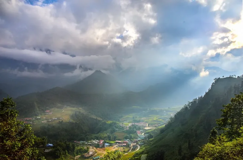
Weather is the defining variable of any Fansipan attempt. The mountain creates its own microclimate, often remaining shrouded in a thick "sea of clouds" while Sapa enjoys sunshine. This phenomenon is part of the mountain's allure; hikers often find themselves climbing through a layer of grey mist only to emerge into brilliant sunshine above the clouds, with the jagged peaks of the Hoang Lien Son range appearing like islands in a white ocean. Conversely, when the weather turns, Fansipan can be a brutal environment of driving rain, biting winds, and near-zero visibility. Success on this trail requires not just physical strength, but the mental resilience to handle the rapidly changing conditions of the high mountains.
History and Cultural Context
The history of Mount Fansipan is deeply intertwined with the colonial and indigenous history of Northwest Vietnam. For the local ethnic minority groups, particularly the Hmong, Dao, and Tay people who have inhabited the valleys surrounding the mountain for centuries, Fansipan was traditionally a sacred and formidable presence. While they utilised the lower slopes for foraging and hunting, the summit was rarely visited, regarded as the domain of spirits. The name "Phan Xi Pang" is believed by some linguists to be derived from a local Hmong dialect, meaning "The Giant Sprouting Rock," a fitting description for its jagged granite profile.
European interest in the mountain began during the French colonial period in the late 19th and early 20th centuries. Sapa was established as a hill station in 1903, serving as a cool-weather retreat for French officials escaping the heat of Hanoi. French botanists and geographers were the first to formally document the mountain's unique flora and fauna, identifying hundreds of species of orchids and rhododendrons found nowhere else in the world. The first recorded ascent by a European occurred during this era, though the mountain remained largely inaccessible to all but the most determined expeditions until the late 20th century.
In recent decades, Fansipan has undergone a dramatic transformation. Following the opening of Vietnam to international tourism in the 1990s, the mountain became a "bucket list" item for domestic and international trekkers. The most significant change occurred in 2016 with the completion of the Fansipan Legend cable car system. This engineering marvel, which holds several world records, has made the summit accessible to millions who would otherwise never experience the "Roof of Indochina." While the cable car has sparked debate regarding environmental impact and the "commercialisation" of the wilderness, it has also funded significant infrastructure improvements at the summit, including a complex of Buddhist temples, statues, and viewing platforms that reflect Vietnam's spiritual heritage. For the hiker, the presence of the cable car offers a unique logistical advantage: the ability to hike up and ride down, saving the knees from a punishing 1,400-metre descent.
Want more background? Read extended notes on history and cultural context → Learn more
Seasonal Highlights and Weather Reality
Timing is everything when planning a Fansipan day hike. The mountain's high altitude and northern latitude mean it experiences a climate vastly different from the tropical heat of Southern Vietnam. There are two primary seasons to consider: the dry season and the wet season.
The Dry Season (October to April): This is the peak window for trekking. From October to December, the air is generally crisp and clear, offering the highest probability of the famous "sea of clouds" views. Temperatures are cool, making for comfortable hiking conditions, though it can be surprisingly cold at the summit, with temperatures occasionally dropping towards 0 degrees Celsius. January and February can be very cold and misty, with occasional frost or even rare snowfall at the highest elevations. March and April are arguably the best months, as the weather warms up and the mountain's famous rhododendrons burst into bloom, painting the slopes in shades of red, pink, and white.
The Wet Season (May to September): This period coincides with the Southeast Asian monsoon. While the landscape is at its most lush and vibrant green, trekking becomes significantly more difficult and dangerous. Heavy rainfall makes the trail's steep sections and rock scrambles incredibly slippery. Leeches are common in the lower forest sections during this time. Furthermore, the summit is frequently "socked in" by clouds for days at a time, meaning you may put in the immense effort of the climb only to see nothing but white mist at the top. If you choose to hike during this season, an early morning start is essential to try and beat the afternoon thunderstorms.
Regardless of the season, hikers must be prepared for "four seasons in one day." It is common to start in humid warmth at Tram Ton Pass, encounter chilling mist in the bamboo forests, and face biting winds at the summit. Always check the local Sapa forecast, but be aware that conditions on the mountain are often much more severe than in the town centre.
Recommended Itinerary
Mount Fansipan Day Hike Itinerary (Tram Ton Route)
06:00 – 06:30: Departure from Sapa
- Organise a taxi or motorbike transfer from Sapa town to the Tram Ton Pass (approx. 15 km).
- The drive takes about 20–30 minutes, passing the Silver Waterfall (Thac Bac).
- Arrive at the Hoang Lien National Park ranger station at Tram Ton Pass (1,900 m).
- Ensure your permits are checked and meet your guide if you have pre-arranged one.
06:30 – 09:00: The Lower Forest to Camp 1
- Distance: Approx. 3.5 km
- Elevation Gain: 300 m
- The trail begins with a relatively gentle ascent through primary forest.
- Cross several small streams and navigate sections of stone steps.
- The canopy provides good shade, but humidity can be high.
- Reach Camp 1 (2,200 m), a basic clearing used by multi-day trekkers. This is a good spot for a quick 10-minute break and water refill.
09:00 – 11:30: The Steep Ascent to Camp 2
- Distance: Approx. 3 km
- Elevation Gain: 600 m
- The terrain becomes significantly steeper and more technical.
- Enter the "bamboo zone," where the trail narrows and involves navigating slippery roots and mud.
- Several sections require the use of hands for balance on rock scrambles.
- The forest begins to thin, offering occasional glimpses of the surrounding valleys.
- Arrive at Camp 2 (2,800 m). This is the traditional lunch spot. The air will be noticeably thinner and cooler here.
11:30 – 13:30: The Ridge and Final Summit Push
- Distance: Approx. 2.5 km
- Elevation Gain: 343 m (with several significant dips and rises)
- This is the most spectacular and physically demanding section.
- The trail follows a jagged ridge line with steep drop-offs (protected by railings in the most exposed areas).
- You will descend into a small valley before the final, punishing climb to the summit complex.
- Pass through high-altitude rhododendron forests.
- The trail eventually meets the stone stairs of the Fansipan Legend summit complex.
13:30 – 14:30: The Summit (3,143 m)
- Celebrate reaching the "Roof of Indochina" at the stainless steel summit pyramid.
- Explore the summit complex, including the Great Buddha Statue, the Bich Van Thien Tu pagoda, and the various viewing platforms.
- If the weather is clear, enjoy 360-degree views across Vietnam and into China.
- Eat your summit snacks and take plenty of photographs.
14:30 – 17:30: The Descent (Option A: On Foot)
- Retrace your steps back down to Tram Ton Pass.
- Note: The descent is often harder on the knees than the ascent and can be very slippery. Allow 3–4 hours.
- Arrange for your taxi to meet you at the ranger station.
14:30 – 15:30: The Descent (Option B: Cable Car)
- Purchase a one-way cable car ticket at the summit station.
- Enjoy a 15-minute scenic ride down to the Fansipan Legend station near Sapa.
- Take a taxi or the mountain monorail back to Sapa town centre.
- This is the highly recommended option for day hikers to avoid injury and enjoy the views.
Planning and Bookings
Book Your Trip
Everything you need to plan your journey
Accommodation
Find places to stay near Sapa
Flights
Search flights to Sapa
Essential Preparation
A day hike of Mount Fansipan is a significant physical undertaking. You should be in good cardiovascular health and have experience with steep, uneven terrain. While the trail is well-marked, the sheer elevation gain (1,400 m) in a short distance is taxing. It is highly recommended to spend at least one or two days in Sapa (1,500 m) prior to the hike to acclimatise to the altitude and recover from the long bus or train journey from Hanoi.
Logistically, Sapa is your base. Most hikers arrive via the overnight sleeper train from Hanoi to Lao Cai, followed by a bus to Sapa, or via the "Sapa Express" bus which takes approximately 5–6 hours directly from Hanoi. In Sapa, you will find numerous trekking agencies. While it is possible to hike independently, the National Park regulations frequently change regarding mandatory guides for foreigners. As of recent years, most hikers are required to be accompanied by a licensed local guide, which can be easily organised through your hotel or an agency in town for approximately US$40–$60 per person (including permits and transport).
Trail Accommodation
This description focuses on the day hike, which requires no overnight accommodation on the mountain. However, for those who find the pace too strenuous, there are two basic camps on the Tram Ton route.
Camp 1 (2,200 m) and Camp 2 (2,800 m): These are not "huts" in the traditional Western sense. They are very basic corrugated iron shelters or wooden shacks managed by local trekking companies. They provide a flat wooden platform for sleeping (mats and sleeping bags usually provided by your guide) and a basic cooking area. There is no electricity, no running water (other than nearby streams), and very primitive pit toilets. If you decide to stay overnight, this must be booked as part of a guided tour package. For day hikers, these camps serve only as rest stops and landmarks.
Sapa Accommodation: Before and after your hike, Sapa offers a wide range of options, from budget hostels in the town centre to luxury eco-lodges overlooking the rice terraces. It is wise to book a hotel with a hot shower and laundry service for your return, as you will likely be covered in mud.
Required Gear
- Hiking Boots: Essential. They must have deep tread for mud and provide ankle support for the rocky sections. Do not attempt this in flat-soled trainers.
- Waterproof Jacket: A high-quality breathable waterproof (Gore-Tex or similar) is mandatory. Even if it doesn't rain, it acts as a windbreak at the summit.
- Layered Clothing: Use a moisture-wicking base layer (merino or synthetic), a warm mid-layer (fleece), and your outer shell. Avoid cotton, which stays wet and cold.
- Hiking Poles: Highly recommended. They are invaluable for saving your knees on the steep steps and providing stability on slippery roots.
- Head Torch: Even if you plan to finish in daylight, a head torch is a vital safety item in case of delays or an early start in the dark.
- Small Backpack: 20–30L with a rain cover to keep your spare layers and food dry.
What to Bring
- Water: Bring at least 2–3 litres. There are no reliable treated water sources on the trail. Your guide may carry extra, but don't rely on it.
- Food: High-energy snacks (nuts, dried fruit, chocolate) and a substantial packed lunch. Most guided tours provide a basic lunch (usually Banh Mi or sticky rice), but supplement this with your own preferences.
- Sun Protection: Sunscreen, sunglasses, and a hat. The UV levels at 3,000 m are intense, even through cloud cover.
- Personal First Aid: Blister plasters (moleskin or Compeed), ibuprofen, and any personal medications.
- Toiletries: Small pack of tissues/toilet paper and hand sanitiser (none provided on trail).
- Power Bank: Cold temperatures drain phone batteries quickly; ensure you have a way to keep your navigation and camera charged.
- Cash: Vietnamese Dong (VND) for the cable car ticket (approx. 850,000 VND) and a tip for your guide.
Permits
Mount Fansipan is located within the Hoang Lien National Park, and a permit is required for all hikers. The permit system is designed to manage hiker numbers and ensure safety in a high-altitude environment where rescues are difficult. As of the current regulations, the permit cost is included in the National Park entrance fee, which is approximately 150,000 VND (roughly US$6).
How to obtain permits:
- Through an Agency: This is the most common and hassle-free method. When you book a guided hike in Sapa, the agency will handle all permit paperwork and fees. You simply provide a copy of your passport.
- At the Trailhead: It is theoretically possible to pay the entrance fee at the Tram Ton Pass ranger station, but rangers may refuse entry to foreigners without a registered guide. It is always safer to organise this in Sapa the day before.
- Passport: You must carry your passport (or a very clear photocopy/photo on your phone) as rangers may check your ID against the permit at the trailhead or at Camp 2.
Cable Car Tickets: If you plan to take the cable car down, you do not need to book this in advance. Tickets can be purchased at the summit station. Note that the price for a one-way trip is often nearly the same as a return trip, but it is a price well worth paying to save your joints from the descent.
Other Activities in the Area
Sapa is the trekking capital of Vietnam, and there is much to see beyond the summit of Fansipan:
- Muong Hoa Valley Trekking: A much gentler alternative to Fansipan, walking through the iconic rice terraces and visiting the villages of the Black Hmong and Giay people (Lao Chai and Ta Van).
- Silver Waterfall (Thac Bac): Located right on the road to Tram Ton Pass, this 200-metre high waterfall is easily accessible and spectacular after rain.
- Love Waterfall (Thac Tinh Yeu): A short, beautiful walk from the Tram Ton Pass ranger station leads to this secluded waterfall, often less crowded than Silver Waterfall.
- Cat Cat Village: A popular walk from Sapa town to a traditional Hmong village. While quite commercialised, the waterfall and traditional performances are worth a visit.
- Bac Ha Market: If your visit coincides with a Sunday, take a day trip to this vibrant ethnic minority market, located about 3 hours from Sapa. It is one of the most colourful markets in Southeast Asia.
- Sapa Glass Bridge (Rong May): For those who haven't had enough heights, this glass walkway extends from the side of a cliff near Tram Ton Pass, offering terrifying views of the valley below.
Safety and Conditions
Altitude Sickness: While 3,143 metres is not high enough to cause severe High Altitude Pulmonary Oedema (HAPO) in most people, many hikers will feel the effects of Acute Mountain Sickness (AMS). Symptoms include headache, nausea, and shortness of breath. If you feel unwell, slow your pace, hydrate, and do not hesitate to descend if symptoms worsen. Acclimatising in Sapa for a day or two is the best prevention.
Weather Hazards: The most significant danger on Fansipan is the weather. Hypothermia is a genuine risk, even in Vietnam, if you get wet and the wind picks up at high altitude. Always carry your waterproof shell. If a heavy storm rolls in, the trail can become a stream; in such cases, it is often safer to wait at one of the camps or the summit complex rather than attempting a slippery descent.
Terrain: The trail is not a "walk in the park." It involves high steps, slippery roots, and sections where you must use your hands. Take your time, especially on the descent. If you are hiking in the wet season, be wary of leeches in the lower forest; tuck your trousers into your socks and use repellent.
Communication: Mobile signal is surprisingly good on much of the Tram Ton route, especially near the summit due to the cable car infrastructure. However, do not rely on it. Ensure someone at your hotel knows your expected return time. If hiking with a guide, they will have radio or phone contact with their base in Sapa.
Emergency: In the event of a serious injury, the cable car can be used for evacuation from the summit. However, getting an injured person from the mid-sections of the trail (like the bamboo forest) to the summit or the trailhead is extremely difficult and would require a team of local porters.
Side Trips and Points of Interest
The Summit Spiritual Complex: Reaching the top of Fansipan is no longer just about a metal pyramid. The "Fansipan Legend" complex is a stunning array of Buddhist architecture built in the style of the 15th-century Tran Dynasty. Key highlights include:
- The Great Buddha Statue: Standing at 21 metres tall, this is the highest bronze Buddha statue in Vietnam. It is a magnificent sight, especially when the clouds swirl around its base.
- Bich Van Thien Tu Pagoda: A beautiful temple complex located at 3,037 metres, offering a place for quiet reflection amidst the mountain air.
- The Grand Bell Tower: An 11-storey tower that houses a massive bronze bell, whose tolling can be heard across the peaks on clear days.
- The 600 Steps: From the cable car station, there are still 600 stone steps to reach the actual summit. For hikers, these are the final "victory laps" of the journey.
The Rhododendron Forests: If you hike in March or April, the "Rhododendron Kingdom" is a major point of interest. Fansipan is home to over 50 species of rhododendrons. The sight of these ancient, gnarled trees covered in vibrant blooms against the backdrop of the rugged granite peaks is one of the most beautiful natural spectacles in Vietnam.
The "Sea of Clouds": This is the most sought-after "point of interest" on Fansipan. It occurs when a temperature inversion traps a layer of cloud in the valleys, leaving the summit in brilliant sunshine. The best time to witness this is early morning during the dry season (October–December).
Leave No Trace
Mount Fansipan has suffered significantly from its own popularity. In the past, litter was a major issue along the trekking routes. As a visitor to this unique ecosystem, you have a responsibility to minimise your impact.
Your responsibility as a walker:
- Pack it in, pack it out: This includes everything from plastic bottles to tiny sweet wrappers and fruit peels. Do not leave anything at the camps or on the trail.
- Stay on the trail: The high-altitude vegetation is fragile. Taking shortcuts on switchbacks causes erosion and destroys rare plant life.
- Respect the wildlife: Do not feed any animals you encounter. The Hoang Lien Son range is home to endangered species like the Black Crested Gibbon; keep noise to a minimum to avoid disturbing them.
- Sanitation: Use the toilets at the trailhead, the camps, or the summit complex. If you must go on the trail, ensure you are at least 50 metres from any water source and bury waste deeply.
- No Fires: The forest and bamboo thickets can be highly flammable during the dry season. Never light a fire on the mountain.
By following these principles, you help ensure that the "Roof of Indochina" remains a pristine wilderness for the next generation of explorers.