Mount Elgon Trek - Journey to the Roof of the World's Largest Caldera
Mount Elgon, an extinct shield volcano straddling the border between Uganda and Kenya, offers one of Africa's most profound wilderness experiences. While it may not reach the dizzying heights of Kilimanjaro or the jagged technicality of Mount Kenya, Elgon boasts the largest volcanic base in the world, spanning approximately 80 kilometres by 50 kilometres. Its crowning glory is a massive collapsed caldera, measuring roughly 8 kilometres in diameter, surrounded by a series of jagged peaks, the highest of which is Wagagai Peak at 4,321 metres on the Ugandan side. This is not merely a mountain climb; it is a journey through a vertical world of ecological transition, from lush montane rainforests and ancient bamboo thickets to high-altitude moorlands populated by prehistoric giant lobelias and groundsels.
The trek is a masterclass in solitude. Unlike the crowded slopes of other East African peaks, Mount Elgon remains relatively untrodden, offering hikers a sense of genuine exploration. The route follows ancient paths used by the Bagisu and Sabiny people, winding past spectacular waterfalls, hidden caves once used as shelters for cattle and humans, and hot springs that bubble within the caldera floor. For those seeking a challenging multi-day trek that combines geological wonder, unique Afro-alpine flora, and deep cultural heritage, the Mount Elgon trek is an unparalleled African adventure. It demands physical resilience and a spirit of adventure, rewarding the persistent with views that stretch across the plains of Eastern Uganda and Western Kenya, often rising above a sea of clouds that blankets the surrounding lowlands.
- Distance: 56.0 km (Sasa Trail return)
- Duration: 4–5 days
- Elevation Gain: 4,321 m (Total height of Wagagai Peak)
- Difficulty: Challenging (High altitude and steep ascents)
- Best Time: December to February and June to August (Dry seasons)
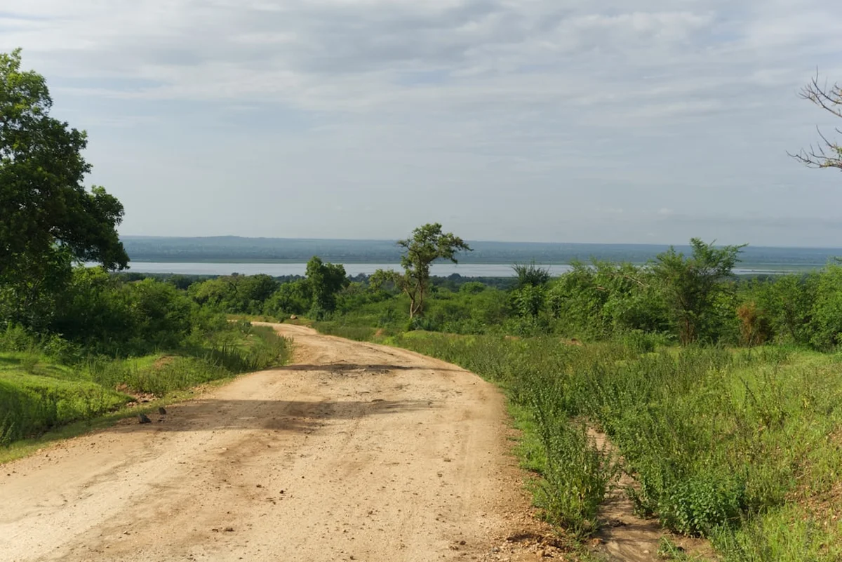
- Closest City: Mbale, Uganda
- Trailhead: Budadiri (Sasa Trail)
- Highest Point: Wagagai Peak (4,321 m)
Overview
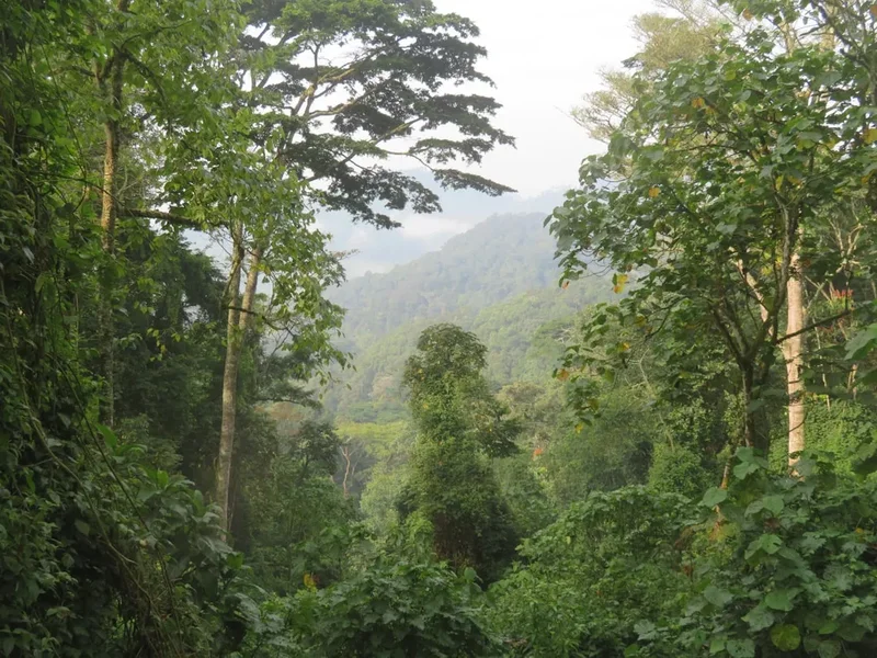
Mount Elgon is a geological titan. Once the highest mountain in Africa, millennia of erosion have lowered its summit, but its massive footprint remains. The trek is defined by its dramatic altitudinal zonation. Starting at the trailhead in Budadiri (approximately 1,250 metres), hikers immediately face the "Wall of Death"—a series of steep metal ladders and rocky switchbacks that climb through the lower montane forest. This initial ascent is a rigorous test of fitness, but it serves as the gateway to a landscape that feels increasingly prehistoric as you climb.
The lower reaches are dominated by lush, humid rainforest, home to blue monkeys, black-and-white colobus monkeys, and a staggering array of birdlife, including the iridescent Tacazze sunbird. As the air thins and cools, the forest gives way to the bamboo zone, a dense and often misty labyrinth that provides a surreal atmosphere for trekking. Above 3,000 metres, the landscape opens into the heath and moorland zones. Here, the vegetation becomes truly alien: giant heathers draped in "old man's beard" lichens, and the iconic giant lobelias (Lobelia elgonensis) and groundsels (Senecio elgonensis) that can grow up to several metres in height. These plants have evolved unique mechanisms to survive the "summer every day, winter every night" climate of the high tropics.
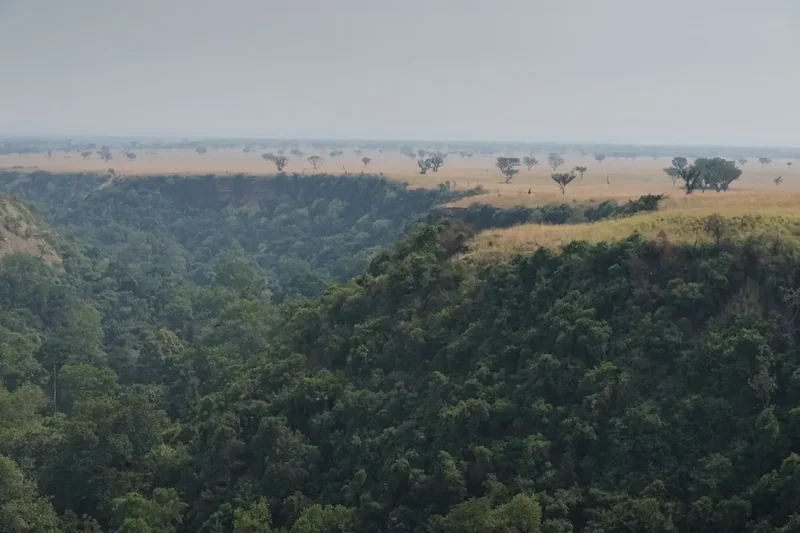
The final push to Wagagai Peak involves traversing the rim of the caldera. The caldera itself is a vast, desolate, and beautiful amphitheatre, often filled with mist or illuminated by the harsh, clear light of high altitude. Standing on the summit, hikers look down into a 40-square-kilometre basin that contains the Suam Gorge and the hot springs. The sense of scale is humbling. Because the mountain is so broad, the gradients are often gentler than those of the Rwenzori Mountains, but the sheer distance and the cumulative effect of altitude make this a serious undertaking. This is a trek for those who value the journey as much as the summit, offering a deep immersion into one of Africa's most diverse and ancient ecosystems.
History and Cultural Context
Mount Elgon, known locally as "Masaba" by the Bagisu people, is more than a geographical feature; it is a sacred ancestor. According to local tradition, Masaba was the founding father of the Bagisu, and the mountain is his physical manifestation. The three main peaks are often interpreted as representing Masaba and his sons. This spiritual connection is most visible during the "Imbalu" circumcision ceremonies, held every even-numbered year. Young men from the surrounding villages travel to the lower slopes of the mountain to undergo traditional rites of passage, a practice that has continued for centuries and remains a cornerstone of Bagisu identity.
The mountain's history is also etched into its geology. Formed over 24 million years ago, Elgon was once a massive active volcano. Its caves, such as Kitum Cave (on the Kenyan side) and various shelters on the Ugandan side, have played vital roles in human and animal history. For generations, these caves provided refuge for local communities during times of conflict and served as salt licks for elephants, who would venture deep into the darkness to gouge salt from the walls with their tusks. On the Ugandan side, caves like Mude and Sasa have historically been used by hunters and herders, and today they serve as atmospheric campsites for trekkers.
European exploration of the mountain began in the late 19th century. Joseph Thomson, a Scottish geologist and explorer, was the first European to document the mountain in 1883, though he did not reach the summit. It wasn't until 1890 that Frederick Jackson and Ernest Gedge reached the caldera rim. In the decades that followed, the mountain became a focal point for botanical and geological research, with scientists fascinated by its unique Afro-alpine flora. Today, Mount Elgon National Park, established in 1992 in Uganda, protects this heritage, balancing the needs of the local communities who live on its fertile lower slopes with the preservation of its unique high-altitude wilderness.
Want more background? Read extended notes on history and cultural context → Learn more
Seasonal Highlights and Weather Reality
Mount Elgon's weather is dictated by its equatorial location and its massive elevation. The mountain experiences two distinct dry seasons and two wet seasons, though at high altitudes, rain can occur at any time of year. Understanding these cycles is crucial for a successful and enjoyable trek.
Dry Seasons (December to February and June to August): These are the optimal windows for trekking. During these months, the skies are generally clearer, providing the best views of the caldera and the surrounding plains. The trails are less muddy, making the steep ascents—particularly the Sasa Trail's "Wall of Death"—significantly safer and more manageable. However, "dry" is a relative term; afternoon showers are still possible, and the summit can be shrouded in mist even during the height of summer. These months also see the coldest night-time temperatures, often dropping below freezing (0°C) at the higher camps like Mude Cave.
Wet Seasons (March to May and September to November): Trekking during these periods is significantly more challenging. The lower forest trails become extremely slippery and muddy, and the "Wall of Death" ladders can be treacherous when wet. Heavy rainfall is common, often lasting for several hours in the afternoon. The cloud cover is much denser, frequently obscuring the views that make the trek so rewarding. However, the wet season brings its own beauty: the waterfalls are at their most thunderous, and the vegetation is incredibly lush and vibrant. For experienced trekkers who don't mind the mud and rain, the mountain is even quieter during these months.
Temperature and Altitude: Regardless of the season, temperature decreases by approximately 6.5°C for every 1,000 metres of ascent. While the base town of Mbale may be a balmy 25–28°C, the summit of Wagagai can be near freezing during the day if the wind is blowing. Wind chill is a major factor on the caldera rim. Trekkers must be prepared for extreme temperature fluctuations, moving from humid tropical heat in the morning to biting alpine cold by evening.
Recommended Itinerary

4-Day Sasa Trail Itinerary (Budadiri to Wagagai Peak)
Day 1: Budadiri to Sasa River Camp
- Distance: 8 km
- Elevation gain: 1,650 m
- Time: 5–7 hours
- Start at the UWA office in Budadiri (1,250 m) for registration and briefing
- Initial walk through local coffee and banana plantations
- Ascend the "Wall of Death"—a series of steep metal ladders and rocky steps through the forest
- Enter the montane forest zone, watching for colobus monkeys
- Arrive at Sasa River Camp (2,900 m) located in a beautiful forest clearing
- This is the most physically demanding day due to the rapid elevation gain
Day 2: Sasa River Camp to Mude Cave Camp
- Distance: 5 km
- Elevation gain: 600 m
- Time: 4–5 hours
- Transition from montane forest into the bamboo zone
- The trail becomes more gradual but can be very muddy in the bamboo thickets
- Emerge into the heath and moorland zone, seeing the first giant lobelias
- Pass through the "Jackson's Pool" area (optional short detour)
- Arrive at Mude Cave Camp (3,500 m)
- The camp is situated near a large cave used historically by herders
- Afternoon rest to aid acclimatisation for the summit push
Day 3: Mude Cave Camp to Wagagai Peak and back to Mude Cave
- Distance: 18 km (return)
- Elevation gain: 821 m
- Time: 8–10 hours
- Early morning start (around 5:00 AM) to catch the sunrise on the moorlands
- Trek through fields of giant groundsels and lobelias
- Reach the caldera rim and follow it towards the summit
- Summit Wagagai Peak (4,321 m)—the highest point on Mount Elgon
- Enjoy views across the massive caldera and into Kenya
- Descend back the same way to Mude Cave Camp for the final night
- This is a long day at high altitude; pace yourself and stay hydrated
Day 4: Mude Cave Camp to Budadiri
- Distance: 13 km
- Elevation loss: 2,250 m
- Time: 6–8 hours
- Long descent back through the bamboo and forest zones
- Careful navigation down the "Wall of Death" ladders (can be hard on the knees)
- Return to the UWA office in Budadiri for checkout
- Transfer back to Mbale for a well-earned meal and hot shower
- Optional: Many hikers choose to extend to a 5th day by traversing to the Sipi Trail instead of returning to Budadiri
Important Notes:
- The Sasa Trail is the fastest but steepest route to the summit
- Acclimatisation is key; do not rush the ascent between Sasa River and Mude Cave
- All treks must be accompanied by a Uganda Wildlife Authority (UWA) ranger-guide
- Porters are highly recommended to support local economies and ease the physical burden
- Water is available at camps but must be treated
Planning and Bookings
Book Your Trip
Everything you need to plan your journey
Accommodation
Find places to stay near Mbale
Flights
Search flights to Mbale
Essential Preparation
Mount Elgon requires a moderate to high level of physical fitness. The first day's ascent of 1,650 metres is particularly gruelling and should not be underestimated. Training with a weighted pack on hilly terrain in the weeks leading up to the trek is strongly advised. Beyond physical fitness, logistical coordination is essential. Most trekkers base themselves in Mbale, a vibrant city at the foot of the mountain. Mbale has several supermarkets (like Shoprite) where you can purchase last-minute supplies, though specialised hiking gear is not available for rent or purchase here—bring everything from home or Kampala.
You must coordinate your trek with the Uganda Wildlife Authority (UWA). While you can show up at the Budadiri office, it is better to contact them or a local tour operator in advance to ensure guides and porters are available, especially during the peak dry seasons. If you are travelling from Kampala, allow 5–7 hours for the drive to Mbale, depending on traffic in Jinja and Iganga.
Trail Accommodation
Accommodation on the Mount Elgon trek is basic and focused on designated wilderness campsites. There are no luxury lodges or serviced huts on the mountain itself.
Campsite Facilities:
- Designated flat areas for pitching tents
- Basic pit latrines (long-drops)
- Natural water sources (streams or springs) nearby
- Some camps (like Mude Cave) have basic wooden shelters, but these are often draughty and should not be relied upon as primary shelter
- No electricity, no charging points, and no mobile signal at most camps
What is NOT Provided:
- Tents and sleeping mats (you must bring your own or hire from an agency in Kampala/Mbale)
- Bedding or sleeping bags
- Cooking equipment or fuel
- Food (you must carry all meals for the duration)
Booking and Costs:
- Park entrance fees are paid at the UWA office (currently approx. US$35 per day for non-residents)
- Guide fees are included in the daily park fee, but porters are paid separately (approx. 15,000–20,000 UGX per day)
- Camping fees are typically included in the trekking package or paid per night at the UWA office
Required Gear
- Hiking Boots: Sturdy, waterproof, and well-broken-in. The "Wall of Death" and bamboo zones require excellent grip.
- Waterproof Jacket and Trousers: Essential for the frequent afternoon rains and mist. Gore-Tex or similar breathable fabric is best.
- Sleeping Bag: A 4-season bag rated to at least -5°C. High-altitude camps are very cold at night.
- Backpack: 50–70L for your main gear (carried by a porter) and a 20–30L daypack for yourself.
- Headlamp: With spare batteries for camp use and the early morning summit push.
- Trekking Poles: Highly recommended for the steep descent on Day 4 to save your knees.
- First Aid Kit: Include blister pads, rehydration salts, and altitude sickness medication (Diamox).
What to Bring
- Food: Lightweight, high-calorie meals (dehydrated meals, pasta, rice, oats). Bring plenty of snacks like nuts, chocolate, and energy bars.
- Water Treatment: Purification tablets or a high-quality filter (e.g., Sawyer Squeeze). Stream water is generally clean but must be treated for safety.
- Cooking System: A lightweight gas or multi-fuel stove. Gas canisters can be hard to find in Mbale; buy them in Kampala.
- Clothing Layers: Merino wool base layers, a fleece mid-layer, and a down jacket for the evenings. Avoid cotton.
- Sun Protection: High-SPF sunscreen, lip balm with SPF, and a wide-brimmed hat. The tropical sun is intense at 4,000 metres.
- Toiletries: Biodegradable soap, wet wipes, and a small trowel for emergency use between camps.
- Cash: Sufficient Uganda Shillings (UGX) for paying porters and tipping guides. There are no ATMs in Budadiri.
Permits
Permits for Mount Elgon are managed by the Uganda Wildlife Authority (UWA). Unlike the gorilla trekking permits in Bwindi, Mount Elgon permits do not usually need to be booked months in advance, but it is wise to notify the UWA office in Mbale or Budadiri at least a few days before your intended start date.
Permit Structure:
- Daily Conservation Fee: This is the primary cost. For foreign non-residents, it is approximately US$35 per day. This fee covers park entry and the mandatory UWA ranger-guide.
- Foreign Residents: Approximately US$25 per day (requires proof of residency).
- East African Community (EAC) Citizens: Approximately 15,000–25,000 UGX per day.
- Payment: Fees are usually paid in US Dollars or Uganda Shillings at the UWA office. Ensure your dollar bills are printed after 2009 and are in pristine condition, as older or damaged notes are often rejected in Uganda.
Logistics and Registration:
- Registration: You must register in person at the UWA office in Budadiri (for the Sasa Trail) or Kapkwata (for the Piswa Trail). You will need to provide your passport details and emergency contact information.
- Guides and Porters: One UWA ranger-guide is mandatory for every group (up to 6–8 people). Porters are optional but highly recommended. They can carry up to 15 kg of your gear. Hiring porters is a direct way to support the local community in Budadiri.
- Insurance: While not a permit requirement, UWA strongly recommends that all trekkers have comprehensive travel insurance that covers high-altitude trekking and emergency evacuation.
Other Activities in the Area
The region around Mount Elgon and Mbale offers several excellent ways to relax or continue your adventure after the trek:
- Sipi Falls: Located on the northern slopes of the mountain, Sipi is a series of three stunning waterfalls. You can take a guided walk to the base of the falls, go abseiling down the main 100-metre drop, or simply enjoy the cooler climate and spectacular views.
- Coffee Tours: The slopes of Mount Elgon produce some of the world's finest Arabica coffee. Many local cooperatives offer "seed to cup" tours where you can pick, roast, and grind your own coffee.
- Rock Climbing: The basalt cliffs around Sipi Falls offer some of the best established rock climbing routes in Uganda, ranging from beginner to advanced levels.
- Nyero Rock Paintings: Located about an hour's drive from Mbale, these ancient geometric rock paintings date back several thousand years and are a significant archaeological site.
- Wanale Ridge: For those with any remaining energy, a day hike up the Wanale Ridge overlooking Mbale offers incredible views and several smaller waterfalls.
- Bull Fighting in Budadiri: If your timing is right, you might witness the traditional (non-lethal) bullfighting matches that are a unique cultural tradition of the Bagisu people.
Safety and Conditions
Altitude Sickness (AMS): This is the primary safety concern on Mount Elgon. The ascent from Budadiri to Mude Cave is rapid. Symptoms of Acute Mountain Sickness (AMS) include headache, nausea, dizziness, and loss of appetite. If symptoms persist or worsen, the only cure is descent. Ensure you drink at least 3–4 litres of water per day and follow the "climb high, sleep low" principle where possible. Discuss the use of Diamox with your doctor before travelling.
Weather Extremes: Hypothermia is a genuine risk, especially if you get wet during an afternoon downpour and then stop moving at a high-altitude camp. Always keep a set of dry clothes in a waterproof dry bag inside your pack. The weather on the caldera rim can change in minutes; if visibility drops, stay with your guide.
The "Wall of Death": Despite its dramatic name, this section of the Sasa Trail is a series of well-maintained metal ladders and stairs. However, it is very steep and can be slippery when wet. Take your time, maintain three points of contact, and do not rush. If you have a severe fear of heights, consider the Piswa or Sipi trails, which are longer but have a more gradual ascent.
Wildlife: While Mount Elgon is home to elephants and buffaloes, they are rarely seen on the main trekking trails. However, they can be dangerous if encountered. Always follow your UWA ranger's instructions; they are armed for protection and trained in wildlife encounters. Do not wander away from the designated camps at night.
Emergency Evacuation: There is no helicopter rescue service on Mount Elgon. In the event of a serious injury or illness, evacuation is typically done by porters using a stretcher to carry the patient down to the nearest trailhead. This can take many hours. Ensure your insurance covers medical repatriation from Mbale or Kampala.
Side Trips and Points of Interest
The Caldera Floor and Hot Springs: If you have an extra day, descending into the caldera floor is highly recommended. The hot springs (Maji ya Moto) bubble at temperatures high enough to boil an egg. The walk across the caldera is eerie and beautiful, feeling like a journey across a different planet. The Suam Gorge, which drains the caldera into Kenya, offers dramatic cliff scenery.
Jackson's Summit: This is a smaller peak (4,165 m) located near the Sasa Trail. It offers a slightly different perspective of the caldera and is a popular alternative or addition to the Wagagai summit. It is named after Frederick Jackson, one of the first Europeans to explore the mountain.
Jackson's Pool: A small, high-altitude tarn located in a natural amphitheatre of rocks. It is a peaceful spot for a break on the way to Mude Cave and is often used as a landmark for navigation in misty conditions.
Dirigana Falls: Located on the lower slopes near the Sasa Trail, these falls are a beautiful spot to visit on the first or last day of the trek. The water cascades over mossy rocks in the heart of the rainforest.
The Bamboo Forest: While part of the main trail, the bamboo zone is a point of interest in itself. During the rainy season, the shoots grow at an incredible rate, and the sound of the wind whistling through the hollow stalks creates a haunting, musical atmosphere.
Leave No Trace
Mount Elgon National Park is a fragile ecosystem under increasing pressure from climate change and human encroachment. As a trekker, it is your responsibility to minimise your impact on this unique environment.
Leave No Trace Principles:
- Pack it in, pack it out: Carry all your rubbish back to Budadiri. This includes organic waste like orange peels and eggshells, which decompose slowly at high altitudes and can attract wildlife to campsites.
- Dispose of waste properly: Use the pit latrines provided at the camps. If you must go between camps, dig a "cathole" at least 15 cm deep and 60 metres away from any water source. Pack out your toilet paper in a sealed bag.
- Stay on the trail: The Afro-alpine vegetation, particularly the mosses and small lobelias, is extremely slow-growing. Stepping off the trail can cause damage that takes years to heal.
- Respect wildlife: Observe animals from a distance. Never feed monkeys or birds, as this disrupts their natural foraging behaviour and can make them aggressive towards humans.
- Leave what you find: Do not pick flowers, especially the giant lobelias, and do not take rocks or ancient artefacts from the caves.
- Minimise campfire impact: Campfires are generally discouraged. Use a stove for cooking. If a fire is necessary for warmth at a designated camp, keep it small and use only dead wood provided by your guide.