Mount Cook Hooker Valley Track - A Journey to the Heart of the Southern Alps
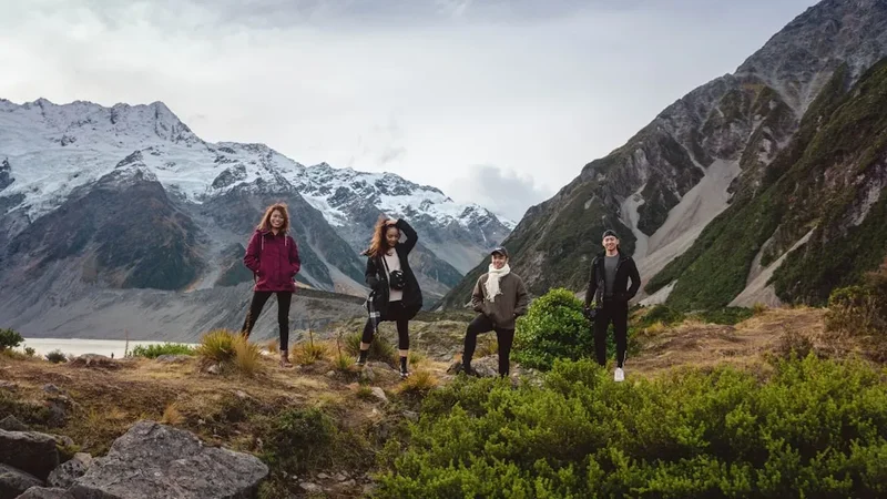
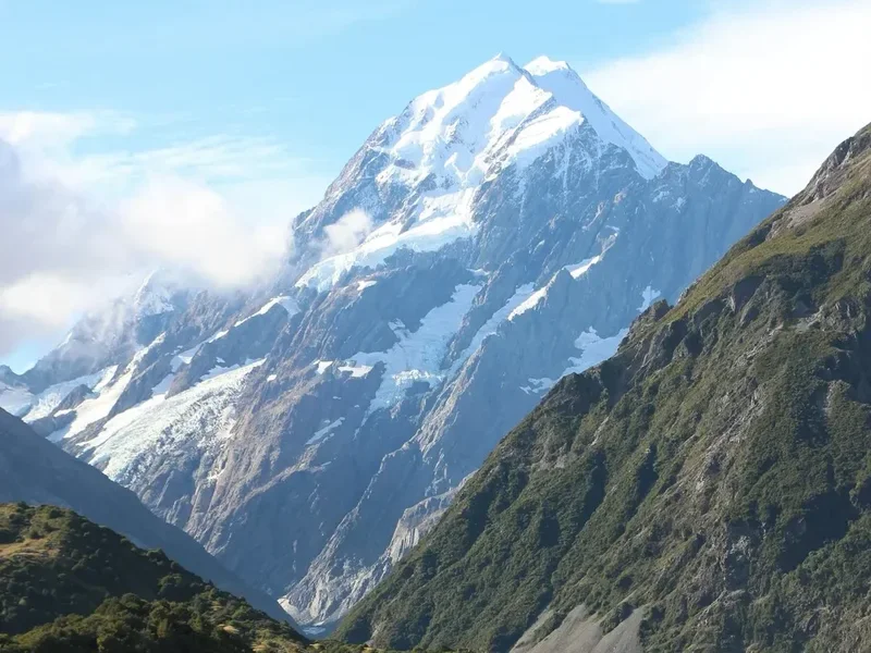
The Mount Cook Hooker Valley Track is arguably New Zealand's most celebrated day walk, offering an unparalleled alpine experience that is accessible to almost anyone with a moderate level of fitness. Located within the awe-inspiring Aoraki/Mount Cook National Park, a UNESCO World Heritage area, this 4.3-kilometre journey (one-way) leads walkers through a landscape of staggering proportions. From the moment you leave the trailhead, you are enveloped by the grandeur of the Southern Alps/Kā Tiritiri o te Moana, with the snow-capped peak of Aoraki/Mount Cook serving as a constant, majestic sentinel at the head of the valley. This is not merely a walk; it is a sensory immersion into a world of ancient ice, turbulent glacial rivers, and resilient alpine flora.
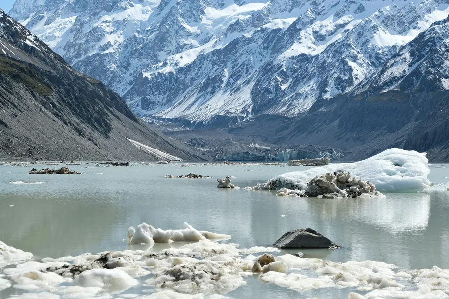
The track is masterfully engineered, featuring three impressive suspension bridges that sway over the grey, silt-laden waters of the Hooker River. These bridges provide not only safe passage but also exhilarating vantage points to witness the raw power of glacial meltwater. As you progress deeper into the valley, the vegetation transitions from hardy sub-alpine scrub to delicate alpine herbs, including the famous Mount Cook Lily (Ranunculus lyallii), which blooms in spectacular white clusters during the late spring and early summer. The journey culminates at the terminal lake of the Hooker Glacier, where icebergs often float serenely in the water, having calved from the glacier's face. Standing at the edge of the lake, with the 3,724-metre summit of Aoraki towering directly above, walkers experience a profound sense of the scale and antiquity of the New Zealand wilderness.
- Distance: 4.3 km one-way (8.6 km return)
- Duration: 1 hour one-way (approximately 3 hours return including stops)
- Elevation Gain: 124 m
- Difficulty: Easy - well-maintained gravel paths and boardwalks
- Best Time: Year-round, though summer (December–February) offers the most stable weather
- Closest City: Twizel (65 km) or Lake Tekapo (100 km)
- Trailhead: Hooker Valley Carpark, near White Horse Hill Campground
Overview
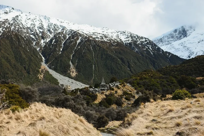
The Hooker Valley Track is a masterclass in accessible wilderness design. It manages to transport walkers into the very core of a high-alpine environment without requiring the technical skills or extreme physical exertion usually associated with such landscapes. The path is predominantly flat, following the natural contours of the valley floor, which was carved out by the massive Hooker and Mueller Glaciers over millennia. Today, the retreat of these glaciers has left behind a dramatic landscape of lateral moraines—huge ridges of rock and debris pushed aside by the ice—which the track skirts and occasionally traverses.
One of the defining characteristics of this walk is the constant presence of water in all its forms. You will hear the distant thunder of avalanches tumbling off the hanging glaciers of Mount Sefton, the rushing roar of the Hooker River as it surges beneath the suspension bridges, and the gentle lap of waves against the rocky shore of the Hooker Lake. The water here is a distinctive "glacial flour" colour—a milky, opaque turquoise or grey caused by fine rock particles suspended in the meltwater. This visual signature of the Southern Alps provides a striking contrast to the dark grey schist of the mountains and the deep green of the valley vegetation.
The track is also a journey through a fragile and unique ecosystem. Because the valley is subject to extreme weather, the plants here have evolved remarkable adaptations. You will see the "vegetable sheep" (Raoulia eximia), dense cushions of tiny plants that look like woolly mounds from a distance, and various species of Celmisia (mountain daisies) that carpet the valley floor in summer. The area is also home to the Kea, the world's only alpine parrot, known for its intelligence and mischievous nature. Seeing a Kea soar overhead, its underwings flashing brilliant orange against the backdrop of the white peaks, is a highlight for many visitors. The Hooker Valley Track offers a rare opportunity to witness these natural wonders in a setting that feels remote and wild, yet remains within reach of a well-prepared day hiker.
History and Cultural Context
For Ngāi Tahu, the Māori iwi (tribe) of the South Island, Aoraki is the most sacred of ancestors. According to tradition, Aoraki and his three brothers were the sons of Rakinui (the Sky Father). They brought their waka (canoe) down from the heavens to visit Papatūānuku (the Earth Mother), but their waka ran aground on a reef and tilted. As the brothers climbed onto the high side of the waka, they were turned to stone by the freezing north wind. The waka became the South Island (Te Waka o Aoraki), and the brothers became the peaks of the Southern Alps, with Aoraki, the tallest, standing as the principal ancestor. This deep spiritual connection is recognised today through the Topuni status of the mountain, which ensures Ngāi Tahu values are integrated into the management of the park.
European history in the valley is inextricably linked to the golden age of mountaineering. In the late 19th and early 20th centuries, the Hooker Valley served as the primary gateway for explorers and climbers attempting to conquer the great peaks of the Southern Alps. The first recorded ascent of Aoraki/Mount Cook took place on Christmas Day, 1894, by Tom Fyfe, Jack Clarke, and George Graham. Their route took them through these very landscapes, though without the benefit of the modern bridges and groomed paths enjoyed by today's walkers. The valley also saw the exploits of Freda Du Faur, the first woman to climb Aoraki, who in 1910 challenged the social conventions of the time by climbing in trousers and without a male chaperone, proving that the high mountains were a place for everyone.
The development of the track itself reflects the changing nature of tourism in New Zealand. Originally a rough route for hardy climbers, it was gradually improved by the Department of Conservation (DOC) and its predecessors to accommodate the growing number of visitors seeking to experience the park's beauty. The current infrastructure, including the three suspension bridges, represents a significant engineering feat, designed to withstand the extreme winds and heavy snowfall of the alpine environment. Today, the track stands as a bridge between the ancient Māori legends of the land and the modern spirit of adventure and conservation.
Want more background? Read extended notes on history and cultural context → Learn more
Seasonal Highlights and Weather Reality
The Hooker Valley Track is a year-round destination, but each season brings a distinct character and set of challenges. Summer (December to February) is the most popular time to visit. The days are long, with twilight lasting until nearly 10:00 PM, and the weather is generally at its most stable. This is the peak blooming season for alpine wildflowers, and the valley is at its most vibrant. However, summer also brings the largest crowds, and the track can feel busy, especially between 10:00 AM and 3:00 PM. It is also the time when the sun is most intense; the high-altitude UV levels in New Zealand are exceptionally high, and sunburn can occur in as little as 15 minutes.
Autumn (March to May) is many locals' favourite time to walk. The air becomes crisp and clear, often providing the best visibility for photography. The summer crowds begin to thin, and the first dustings of new snow often appear on the lower peaks, creating a beautiful "sugar-coated" effect. Winter (June to August) transforms the valley into a true alpine wonderland. The track is often covered in snow or ice, requiring sturdy boots and sometimes crampons or ice grippers. The Hooker Lake may partially freeze, and the surrounding mountains are draped in heavy white blankets. While spectacular, winter walking requires careful attention to weather forecasts, as storms can move in rapidly, bringing sub-zero temperatures and gale-force winds.
Spring (September to November) is a season of dramatic change. As the snow melts, the Hooker River swells with runoff, and the waterfalls cascading down the valley walls become thunderous. This is also the most volatile season for weather, with the "Nor'wester" winds frequently lashing the park. These winds can be incredibly powerful, occasionally forcing the closure of the suspension bridges for safety. Regardless of the season, walkers must be prepared for "four seasons in one day." The Southern Alps create their own microclimate, and a blue-sky morning can easily turn into a sleet-filled afternoon. Always check the latest mountain forecast at the DOC Visitor Centre before setting out.
Recommended Itinerary
Hooker Valley Track Route Progression
Waypoint 1: White Horse Hill Carpark to Mueller Lookout
- Distance: 0.8 km
- Time: 15–20 minutes
- The journey begins at the White Horse Hill Carpark, located at the end of Hooker Valley Road.
- The path is wide and gravelled, passing through open tussock land.
- Shortly after starting, you reach the Mueller Lookout. This provides your first elevated view of the Mueller Glacier's terminal lake and the moraine walls.
- To your left, you will see the Alpine Memorial, a sobering reminder of the climbers who have lost their lives in the park.
- The view from here sets the scale for the rest of the walk, with Mount Sefton dominating the skyline.
Waypoint 2: First Suspension Bridge to Second Suspension Bridge
- Distance: 1.2 km
- Time: 20–25 minutes
- The track descends slightly to the first suspension bridge, which crosses the Hooker River near its exit from the Mueller Lake.
- Crossing the bridge is an experience in itself, as you feel the sway and hear the roar of the grey water below.
- After the bridge, the track winds around the base of the Mueller Glacier's lateral moraine.
- This section offers excellent opportunities to see alpine plants nestled among the rocks.
- The second suspension bridge is arguably the most photogenic, with Aoraki/Mount Cook perfectly framed in the valley beyond.
Waypoint 3: Second Suspension Bridge to Stocking Stream
- Distance: 1.0 km
- Time: 15–20 minutes
- After crossing the second bridge, the track enters a more open section of the valley floor.
- You will pass through areas of boardwalk designed to protect the fragile wetlands and alpine bogs.
- Stocking Stream provides a perfect halfway point for a short rest. There is a small shelter here and toilets.
- The views of the Hooker River winding through the valley are spectacular here, with the massive bulk of the Footstool and Mount Sefton looming to the west.
Waypoint 4: Third Suspension Bridge to Hooker Lake
- Distance: 1.3 km
- Time: 20–25 minutes
- The final leg of the journey takes you across the third and final suspension bridge.
- The track climbs gently over the final moraine ridge. This is the most significant elevation gain of the walk, but it is brief and well-stepped.
- As you crest the ridge, the Hooker Lake and the terminal face of the Hooker Glacier suddenly come into view.
- The track ends at a dedicated lookout point with picnic tables, though many walkers choose to head down to the rocky shore of the lake.
- Spend time here watching for icebergs and listening for the "white noise" of the mountains—the constant, subtle sounds of shifting ice and falling rock.
Important Notes:
- The times listed are for a steady walking pace; allow extra time for photography and bridge crossings.
- The return journey follows the same path and generally takes slightly less time as it is marginally downhill.
- The track is very popular; starting before 8:00 AM or after 4:00 PM (in summer) will provide a much quieter experience.
- High winds can make the suspension bridges challenging; hold onto the handrails and keep children close.
Planning and Bookings
Book Your Trip
Everything you need to plan your journey
Accommodation
Find places to stay near Twizel
Flights
Search flights to Twizel
Essential Preparation
While the Hooker Valley Track is an easy walk, its location in a high-alpine environment means that preparation is key to a safe and enjoyable experience. There is no public transport directly to the trailhead, so most visitors arrive by private vehicle or via shuttle services from nearby towns. The closest service hub is Mount Cook Village, located just 2 kilometres from the trailhead. The village has a world-class DOC Visitor Centre, which is an essential first stop for up-to-date weather information, track conditions, and fascinating exhibits on the park's natural and human history.
Fitness requirements are modest; if you can walk on flat ground for three hours, you can complete this track. However, the alpine sun and wind can be draining, so ensure you are well-hydrated and nourished before starting. If you are staying in Twizel or Lake Tekapo, allow at least 45 to 60 minutes for the drive to the park, as the scenery along Lake Pukaki is so spectacular you will inevitably want to stop for photos. Ensure your vehicle has a full tank of fuel, as there are limited and expensive refuelling options within the National Park itself.
Trail Accommodation
This is a day hike requiring no overnight accommodation on the track itself. Camping is strictly prohibited along the Hooker Valley Track to protect the fragile alpine environment and maintain the experience for all visitors. However, there are several excellent options for staying near the trailhead to allow for an early start.
Nearby Options:
- White Horse Hill Campground: Located at the trailhead. This is a DOC-managed site suitable for tents and campervans. It offers basic facilities including toilets, a large sheltered cooking area (bring your own stove), and treated water. Bookings are required through the DOC website, especially during the summer months. Cost is approximately NZ$15 per adult per night.
- Mount Cook Village: Offers a range of accommodation from the luxury Hermitage Hotel to the YHA backpackers and various motels. These should be booked many months in advance, as they frequently sell out during the high season.
- Mueller Hut: For those seeking an overnight alpine experience, the Mueller Hut is a separate, much more challenging hike that branches off from the Sealy Tarns track near the Hooker Valley trailhead. This requires a separate booking and advanced fitness.
Required Gear
- Sturdy Footwear: While the track is well-maintained, the gravel can be loose and the boardwalks slippery when wet. Light hiking boots or high-quality trail running shoes with good grip are recommended.
- Layered Clothing: The temperature can drop significantly as you move deeper into the valley or if the sun goes behind a cloud. Wear a moisture-wicking base layer (merino or synthetic), an insulating mid-layer (fleece), and carry a windproof/waterproof outer shell.
- Sun Protection: A broad-brimmed hat, high-SPF sunscreen, and quality sunglasses are non-negotiable. The reflection of the sun off the snow and ice increases UV exposure significantly.
- Day Pack: A 15–25L pack to carry your layers, water, and food.
- Communication: While there is some mobile coverage near the start of the track, it becomes unreliable deeper in the valley. A fully charged phone is essential, and for those walking alone or in winter, a Personal Locator Beacon (PLB) is a wise precaution.
What to Bring
- Water: Bring at least 1.5 litres of water per person. While there are streams, the presence of heavy tourist traffic and wildlife means water should be treated or filtered if collected from the land.
- High-Energy Snacks: Even an easy walk burns calories in the cold alpine air. Bring nuts, dried fruit, chocolate, or energy bars. A picnic lunch to enjoy at Hooker Lake is a highlight of the trip.
- First Aid Kit: A basic kit containing blister plasters, antiseptic wipes, and any personal medications.
- Camera/Smartphone: You will want to take many photos. Ensure you have plenty of space on your memory card and a full battery.
- Trash Bag: There are no bins on the track. You must carry out all your rubbish, including organic waste like apple cores or orange peels, which do not decompose quickly in the cold alpine environment.
Permits
One of the great appeals of the Hooker Valley Track is that no permits or entry fees are required to walk it. Aoraki/Mount Cook National Park is free for all to enter and enjoy. This accessibility is part of New Zealand's commitment to providing public access to its most spectacular natural spaces. However, there are some administrative and safety considerations to keep in mind.
Key Information:
- No Booking Required: You do not need to book a time slot or register your intention to walk the Hooker Valley Track at the Visitor Centre, although it is always good practice to let someone know your plans.
- Parking: The White Horse Hill Carpark is free, but it can fill up completely by mid-morning during the summer. If the carpark is full, you may need to park in Mount Cook Village and walk the additional 2 kilometres to the trailhead via the Kea Point Track or the village connector path.
- Commercial Groups: If you are leading a commercial tour or a large organised group (over 15 people), you may require a concession from the Department of Conservation.
- Drone Use: The use of drones is strictly prohibited in Aoraki/Mount Cook National Park without a specific permit from DOC. This is to protect the privacy of other visitors, the safety of helicopters operating in the area, and the peace of the wilderness. Permits are rarely granted for recreational use.
While the walk itself is free, please consider making a donation at the DOC Visitor Centre. These funds go directly toward the maintenance of the tracks and the protection of the park's unique biodiversity, ensuring that the Hooker Valley remains in pristine condition for future generations.
Other Activities in the Area
Aoraki/Mount Cook National Park is a hub for outdoor enthusiasts, and the Hooker Valley Track is often just the beginning of a visit. Consider these other experiences to round out your trip:
- Tasman Glacier Viewpoint: A short drive to the other side of the range leads to the Tasman Valley. A 20-minute walk takes you to a viewpoint overlooking New Zealand's longest glacier and its terminal lake, which often features much larger icebergs than the Hooker Lake.
- Glacier Explorers Boat Trip: For a closer look at the ice, you can take a guided boat tour on the Tasman Glacier terminal lake. This allows you to touch the icebergs and see the massive face of the glacier from water level.
- Stargazing: The park is part of the Aoraki Mackenzie International Dark Sky Reserve, one of the best places in the world for stargazing. Several operators in the village offer guided telescope tours, or you can simply step outside on a clear night to see the Milky Way in incredible detail.
- Sir Edmund Hillary Alpine Centre: Located at the Hermitage Hotel, this centre features a 3D cinema, planetarium, and a museum dedicated to the history of the region and New Zealand's most famous explorer.
- Kea Point Track: A shorter, flatter alternative to the Hooker Valley (1 hour return) that offers views of the Mueller Glacier moraine and Mount Sefton.
- Scenic Flights: For the ultimate perspective, helicopter or ski-plane flights offer "snow landings" on the upper reaches of the glaciers, providing views of both the East and West Coasts of the South Island.
Safety and Conditions
Alpine Weather: The most significant danger in the Hooker Valley is the weather. The Southern Alps act as a barrier to the moisture-laden winds from the Tasman Sea, resulting in rapid and violent weather changes. Even if the sun is shining, always carry a waterproof jacket and warm layers. Hypothermia is a real risk if you become wet and the wind picks up, even in temperatures well above freezing.
Wind Hazards: The valley acts as a funnel for the wind. On "Nor'wester" days, gusts can exceed 100 km/h. The suspension bridges are designed to move, but in extreme winds, they can become dangerous to cross. If you find it difficult to stand or walk against the wind, it is time to turn back. DOC staff will occasionally close the track if conditions are deemed too hazardous.
Rockfall and Avalanches: While the track is generally safe from direct avalanche paths, you will frequently hear and see them on the distant slopes of Mount Sefton. Do not venture off the marked track onto the moraine walls, as these are unstable and prone to localized rockfall. The terminal lake shore can also be hazardous; never walk on the ice of the lake, as it is thin and the water beneath is near freezing.
Sun and Hydration: The thin alpine air and high UV levels mean you will burn and dehydrate faster than at sea level. Apply sunscreen frequently, wear a hat, and drink plenty of water. If you begin to feel dizzy or develop a headache, find shade and rest immediately.
Emergency Procedures: In the event of an injury, stay with the person and keep them warm. Use your mobile phone to call 111 (New Zealand's emergency number), but be aware that signal is patchy. If you have no signal, you may need to send a member of your party back to the trailhead or the Visitor Centre to raise the alarm. This is why carrying a PLB is highly recommended for all hikers in New Zealand.
Side Trips and Points of Interest
The Alpine Memorial: Located just a short walk from the start of the track, this stone pyramid is a poignant site. It bears the names of many climbers and guides who have perished in the surrounding mountains. It serves as a powerful reminder of the respect that these peaks demand and offers a quiet place for reflection with a stunning view of the Mueller Glacier.
Freda's Rock: A large boulder located near the start of the track where Freda Du Faur was famously photographed. It has become a symbol of the pioneering spirit of women in mountaineering. It is a popular spot for a quick photo before the valley opens up.
The Mount Cook Lily (Ranunculus lyallii): While not a "side trip" in the geographic sense, seeking out these flowers is a seasonal quest. They are actually the world's largest buttercup, not a lily. Look for them in the damp, sheltered hollows along the boardwalk sections between the second and third bridges from November to January. Their large, cup-shaped green leaves are visible year-round.
Mueller Lake Shore: While the main track stays high on the moraine, there are small, informal paths that lead down to the edge of the Mueller Lake near the first bridge. This offers a different perspective on the grey, silty water and the sheer walls of the moraine that hem it in. Be cautious of the unstable ground near the water's edge.
Leave No Trace
Aoraki/Mount Cook National Park is a pristine environment that faces significant pressure from high visitor numbers. Following the Leave No Trace principles is essential to ensure the park remains healthy and beautiful. The alpine ecosystem is incredibly slow to recover; a single footstep off the track can destroy a plant that has taken twenty years to grow.
Your responsibility as a walker:
- Stay on the Track: The gravel paths and boardwalks are there for a reason. Walking off-track compresses the soil and kills delicate alpine herbs and mosses.
- Pack it In, Pack it Out: This includes everything. Even biodegradable items like banana peels or nut shells take years to break down in this cold climate and can attract pests or harm native birds.
- Respect the Wildlife: Never feed the Kea. Feeding them makes them dependent on humans, encourages them to hang around carparks where they are at risk from vehicles, and can make them sick. Secure your gear, as Kea are famous for "stealing" items from unattended packs.
- Toilets: Use the facilities at the trailhead or at Stocking Stream. If you are caught short, move at least 50 metres from the track and any water sources, and bury all waste deeply. Carry out your toilet paper in a sealed bag.
- Leave What You Find: Do not take rocks, plants, or any other natural items. Leave them for others to enjoy.
- Be Considerate: Keep noise levels down. People come here to experience the sounds of nature. If you are using a phone for music, use headphones.