Mount Cameroon Summit Trek - The Chariot of the Gods
Mount Cameroon, known locally as Mongo ma Ndemi (Mountain of Greatness) or Fako, is the highest peak in West and Central Africa, rising majestically to 4,040 metres above the Gulf of Guinea. This active stratovolcano is not merely a geographical landmark but a spiritual titan for the Bakweri people and a formidable challenge for trekkers from across the globe. The journey to the summit is a vertical odyssey that traverses an incredible diversity of ecosystems, beginning in the humid, lush tropical rainforests at the base, ascending through montane forests and high-altitude grasslands, and finally reaching the stark, lunar-like volcanic desert of the summit plateau. It is one of the few places on Earth where one can climb from sea level to over 4,000 metres in such a short horizontal distance, offering a condensed masterclass in ecological transition.
The trek is famously associated with the "Mount Cameroon Race of Hope," an annual extreme marathon where athletes sprint to the summit and back in under five hours—a feat that seems impossible to the average hiker who takes two to three days to complete the same distance. For the recreational trekker, the experience is defined by the sheer scale of the ascent, the dramatic volcanic craters that pockmark the slopes, and the breathtaking views of the Atlantic Ocean shimmering in the distance. Whether you are navigating the misty "Elephant Forest" or standing atop the highest point in the region, Mount Cameroon provides a raw, uncommercialised wilderness experience that demands physical resilience and rewards it with unparalleled natural beauty.
- Distance: 60.0 km (approximate return route via Main Path)
- Duration: 2–3 days
- Season: November to March (Dry season is essential for safety and views)
- Accommodation: Basic mountain huts (Hut 1, Hut 2, Hut 3)
- Highest point: Fako Summit (4,040 m)
- Elevation Gain: 4,040 m from sea level (approx. 3,100 m from Buea trailhead)
- Difficulty: Challenging (High physical demand due to rapid elevation gain)
- Closest City: Buea, Southwest Region, Cameroon
Overview
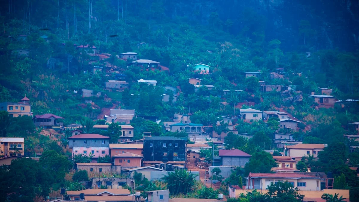
Mount Cameroon is a geological marvel, an active volcano that has erupted seven times in the last century, most recently in 1999 and 2000. This volcanic activity has created a landscape of constant renewal, where ancient lava flows are slowly being reclaimed by pioneer plant species and new craters stand as reminders of the Earth's internal power. The trek is primarily accessed from the town of Buea, which sits at approximately 900 metres on the mountain's lower slopes. From here, the path is a relentless upward climb, testing the cardiovascular endurance of even the most seasoned hikers. The lack of switchbacks on many sections of the "Main Path" means the gradient is often steep and direct, requiring a steady pace and frequent hydration.
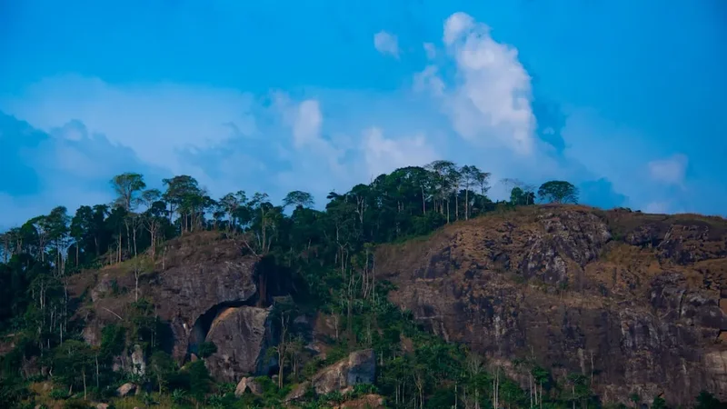
The ecological zoning of Mount Cameroon is perhaps its most striking feature. The lower slopes are dominated by sub-montane forest, home to a variety of bird species and the elusive forest elephant. As you ascend past 1,500 metres, the canopy thins into montane forest, often shrouded in mist and draped in epiphytic mosses and ferns. Above 2,000 metres, the forest gives way abruptly to vast sub-alpine grasslands. These rolling hills of yellowing grass are punctuated by charred protea shrubs and volcanic outcrops, offering the first expansive views of the surrounding plains and the distant coastline. The final transition occurs above 3,000 metres, where the vegetation becomes sparse and the landscape turns into a high-altitude volcanic desert of black scree, red volcanic dust, and jagged basalt formations.
The summit itself, known as Fako, is a broad, windswept plateau. Reaching the "Summit Bottle"—the traditional marker at the highest point—is a moment of profound achievement. On a clear day, the panorama is staggering: to the west lies the Atlantic Ocean and the island of Bioko in Equatorial Guinea; to the east, the lush green canopy of the Congo Basin stretches toward the horizon. However, the mountain is notorious for its unpredictable weather. Even in the dry season, the summit can be engulfed in clouds within minutes, and temperatures can drop below freezing, a stark contrast to the sweltering tropical heat of the lowlands. This trek is not just a physical journey; it is a sensory experience that moves from the smell of damp earth and tropical flowers to the thin, crisp air of the alpine heights.
History and Cultural Context
The history of Mount Cameroon is a blend of ancient mythology, colonial exploration, and modern athletic prowess. To the local Bakweri people, the mountain is the home of Efasa Moto, a half-man, half-stone deity who guards the heights. Traditional belief holds that Efasa Moto controls the volcanic eruptions and the weather; trekkers are often encouraged by local guides to show respect to the mountain to ensure safe passage. The mountain is a sacred site, and many of the names of the craters and landmarks are rooted in Bakweri folklore, reflecting a deep-seated spiritual connection that predates European arrival.
The first recorded sighting of the mountain by Europeans was by the Carthaginian explorer Hanno the Navigator in the 5th century BC. He described a "great fire" rising to the stars, which he named the "Chariot of the Gods" (Theon Ochema). It wasn't until 1861 that the summit was officially reached by European explorers, specifically Sir Richard Francis Burton and the German botanist Gustav Mann. During the German colonial period, the town of Buea served as the capital of German Kamerun, chosen for its cooler climate and strategic position on the mountain's slopes. The colonial architecture still visible in Buea today, including the Schloss (the former governor's residence), serves as a reminder of this era.
In modern times, the mountain has gained international fame through the "Mount Cameroon Race of Hope." Started in 1973, this extreme uphill and downhill race attracts hundreds of participants who compete in one of the most gruelling athletic events on the continent. The race has become a symbol of national pride and resilience, and the path used by the runners is the same "Main Path" taken by trekkers. Walking this route provides a humbling perspective on the incredible speed and stamina of the local athletes who navigate the steep scree slopes with ease. The mountain remains a focal point for scientific research, particularly in volcanology and botany, as it hosts several endemic species that are found nowhere else on Earth.
Want more background? Read extended notes on history and cultural context → Learn more
Seasonal Highlights and Weather Reality
The timing of a Mount Cameroon trek is critical, as the weather dictates both the safety and the enjoyment of the experience. The region follows a tropical monsoon climate, characterised by a distinct dry season and a heavy rainy season. Attempting the summit outside of the recommended window can be dangerous due to slippery trails, poor visibility, and the risk of lightning strikes on the exposed upper slopes.
Dry Season (November to March): This is the peak trekking season. During these months, the skies are generally clearer, and the trails are dry, making the steep ascents and descents more manageable. January and February are particularly popular, though they coincide with the "Harmattan"—a seasonal wind from the Sahara that can bring a hazy dust to the air, sometimes obscuring long-distance views. Temperatures in the lowlands remain high (25–30°C), but as you ascend, the air cools significantly. At Hut 2 and above, night-time temperatures can drop to 5–10°C, and at the summit, they can hover around 0°C.
Shoulder Season (April and October): These months mark the transition between seasons. Trekking is possible but carries a higher risk of afternoon thunderstorms. The landscape is exceptionally green and vibrant during these times, and the dust of the Harmattan is washed away, often resulting in the crispest views when the clouds part. However, hikers must be prepared for wet gear and muddy paths in the forest zones.
Rainy Season (May to September): This period is generally avoided by trekkers. Mount Cameroon is one of the wettest places on Earth; the village of Debundscha at its base receives over 10,000 mm of rain annually. On the mountain, the rain can be relentless, turning the trails into treacherous mud slides and making the volcanic scree on the upper slopes incredibly unstable. Visibility is often near zero, and the risk of hypothermia increases as hikers become soaked in the cold, high-altitude winds. Most organised tours do not operate during the height of the rains.
Recommended Itinerary
3-Day Mount Cameroon Summit Itinerary
Day 1: Buea to Hut 2
- Distance: 12 km
- Elevation gain: 1,900 m
- Time: 6–8 hours
- Start at the MINFOF (Ministry of Forestry and Wildlife) office in Buea (approx. 900 m)
- Ascend through the "Upper Farms" area, passing through local plantations
- Enter the tropical rainforest zone, often referred to as the "Elephant Forest"
- Pass Hut 1 (1,875 m) – a good spot for a mid-morning break and water refill
- The gradient steepens significantly after Hut 1 as you transition from forest to savannah
- Arrive at Hut 2 (2,780 m) in the late afternoon
- Set up camp or settle into the basic hut; enjoy the sunset over the clouds
- This is a demanding day with significant vertical gain; pace yourself to avoid early exhaustion
Day 2: Hut 2 to Summit and back to Hut 2 (or Hut 3)
- Distance: 15 km (return)
- Elevation: 1,260 m gain to summit, 1,260 m descent
- Time: 7–9 hours
- Early morning start (usually 5:00 AM) to catch the sunrise and avoid midday clouds
- Climb through the high-altitude grasslands toward Hut 3 (3,950 m)
- The terrain becomes increasingly volcanic, with loose scree and basalt rocks
- Pass the "Intermediate" point and the 1999 lava flow areas
- Final push to the Fako Summit (4,040 m) and the iconic "Summit Bottle"
- Spend time on the plateau exploring the various craters and taking in the 360-degree views
- Descend back to Hut 2 for the night, or continue to Hut 3 if planning a different descent route
- The descent on loose volcanic scree is taxing on the knees; trekking poles are highly recommended
Day 3: Hut 2 to Buea via the "Main Path" or "Guinness Route"
- Distance: 12 km
- Elevation: 1,900 m descent
- Time: 4–5 hours
- Breakfast at Hut 2 while watching the morning mist rise from the valleys
- Begin the long descent back through the savannah and into the forest
- The path can be slippery, especially in the forest zone where morning dew lingers
- Pass back through Hut 1 and the Upper Farms
- Arrive back in Buea by early afternoon
- Celebrate the successful summit with a cold drink and a traditional meal in town
- Optional: Visit the local German colonial sites in Buea before departing for Douala or Limbe
Important Notes:
- A guide is mandatory for all hikers; porters are highly recommended to assist with water and gear
- Water sources are limited; ensure you carry enough for each stage as advised by your guide
- Altitude sickness can occur; if you feel severe headaches or nausea, inform your guide immediately
- The "Race of Hope" route is the most direct but also the steepest; alternative routes like the "Mann's Spring" route offer a more gradual but longer experience
- Always check the volcanic activity status before starting your trek
Planning and Bookings
Book Your Trip
Everything you need to plan your journey
Accommodation
Find places to stay near Buea
Flights
Search flights to Buea
Essential Preparation
Planning a trek on Mount Cameroon requires more than just physical fitness; it involves coordinating with local authorities and ensuring you have the right support team. The trek begins in Buea, which is easily accessible from Douala (the main international gateway) via a 1.5-hour drive. It is highly recommended to arrive in Buea at least one day before your trek to meet your guide, finalise permits, and acclimatise to the local humidity. Physical preparation should focus on cardiovascular endurance and leg strength, as the ascent is relentless. If you are not used to high altitudes, consider a slower 4-day itinerary to allow for better acclimatisation.
Booking a guide is not just a safety requirement; it is a legal one. The Mount Cameroon Inter-Communal Guide Association (ICGA) in Buea is the primary body for organising treks. They can provide certified guides, porters, and cooks. Porters are invaluable, as they carry the bulk of the water, food, and camping equipment, allowing you to focus on the climb. It is best to arrange these services a few weeks in advance, especially during the peak season of December and January.
Trail Accommodation
Accommodation on Mount Cameroon is rudimentary and designed for utility rather than comfort. There are three main "huts" along the Main Path, though these are often simple concrete shelters or wooden cabins with basic bunk platforms.
Hut Facilities:
- Basic wooden or concrete bunk platforms (no mattresses provided; sleeping mats are essential)
- Simple sheltered areas for cooking (usually over small gas stoves or wood fires)
- Pit toilets are available at Hut 2, but facilities are extremely basic
- No running water or electricity at any of the huts
- Hut 2 is the most common overnight stop and offers the best protection from the wind
- Hut 3 is very close to the summit and is typically used only in emergencies or for very early summit pushes
What Huts Don't Provide:
- Bedding, pillows, or blankets
- Food or water (all must be carried up)
- Heating (it gets very cold at night; a high-quality sleeping bag is mandatory)
- Lighting (bring a head torch with extra batteries)
- Waste disposal (you must pack out all rubbish)
Booking Requirements:
- Hut fees are usually included in your overall trekking permit or guide package
- There is no formal "reservation" system for specific bunks; it is first-come, first-served, though guides coordinate to ensure everyone has space
- Camping in tents outside the huts is common and often more comfortable than sleeping inside the crowded shelters
Required Gear
- Sturdy trekking boots - Must have excellent grip for volcanic scree and be well broken-in
- Trekking poles - Essential for saving your knees during the 3,000 m descent
- High-quality sleeping bag - Rated for at least 0°C; the temperature at Hut 2 and above drops significantly
- Insulated sleeping mat - To provide a barrier between you and the cold hut floor or ground
- Waterproof jacket and trousers - Even in the dry season, mist and sudden showers are possible
- Layered clothing - Moisture-wicking base layers, a fleece mid-layer, and a down jacket for the summit
- Head torch - Essential for the early morning summit push and navigating the huts at night
- Sun protection - High SPF sunscreen, lip balm, and a wide-brimmed hat (the tropical sun is intense at high altitude)
- Small backpack (20-30L) - For your daily essentials if porters are carrying your main bag
What to Bring
- Water - At least 3–4 litres per day. There are very few reliable water sources on the mountain
- High-energy food - Trail mix, energy bars, chocolate, and dried fruit for quick energy
- Main meals - If not provided by your tour, bring lightweight, calorie-dense dehydrated meals
- Water purification - Tablets or a filter for any water collected from springs (e.g., at Mann's Spring)
- Personal first aid kit - Include blister pads, rehydration salts, ibuprofen, and any personal medications
- Toiletries - Biodegradable wet wipes, hand sanitiser, and toilet paper (pack it out!)
- Power bank - To keep your phone or camera charged for photos
- Small microfibre towel - For basic hygiene at the huts
- Cash - Small denominations of Central African CFA francs (XAF) for tipping guides and porters
Permits
Access to Mount Cameroon is strictly regulated by the Ministry of Forestry and Wildlife (MINFOF). You cannot simply start walking up the mountain; you must obtain a permit and be accompanied by a registered guide. This system is in place to ensure hiker safety, manage environmental impact, and provide employment for the local community.
Permit Process:
- Permits are typically issued at the MINFOF office or through the Guide Association office in Buea
- You will need to provide your passport details and pay the required fees in cash (CFA francs)
- The permit fee usually covers the "park entry" and a contribution to local community development
- If you book through a trekking agency, they will usually handle all permit logistics for you
Costs (Approximate):
- Park Entry Fee: Approximately 5,000 to 10,000 XAF per person
- Guide Fees: Approximately 15,000 to 20,000 XAF per day
- Porter Fees: Approximately 8,000 to 10,000 XAF per day
- Note: Prices can fluctuate, and it is customary to tip your support team at the end of the trek (usually 10–20% of the total fee)
Regulations:
- Solo trekking is strictly prohibited
- You must stick to the designated trails to protect the fragile alpine ecosystem
- All volcanic activity warnings must be heeded; the mountain is monitored, and certain areas may be closed if seismic activity increases
Other Activities in the Area
The Southwest Region of Cameroon offers several excellent options for post-trek relaxation and exploration:
- Limbe Botanic Garden: Located about an hour from Buea, this is one of the oldest botanical gardens in Africa. It’s a peaceful place to walk and learn about the region's diverse flora.
- Limbe Black Sand Beaches: The volcanic activity of Mount Cameroon has created unique black sand beaches. Relax by the Atlantic Ocean and enjoy fresh grilled fish at the local "down beach" restaurants.
- Buea Colonial Architecture: Take a walking tour of Buea to see the German-era buildings, including the Prime Minister's Lodge and the old post office.
- Limbe Wildlife Centre: A world-class sanctuary for rescued primates, including gorillas, chimpanzees, and drills. It is an excellent place to learn about conservation efforts in Cameroon.
- Tea Plantations: Visit the sprawling Tole Tea estates on the lower slopes of the mountain to see how one of Cameroon's most famous exports is grown and processed.
Safety and Conditions
Mount Cameroon is a serious undertaking that requires respect for the environment and an honest assessment of your physical limits. The most common safety issues are related to altitude, weather, and the physical nature of the terrain.
Altitude Sickness (AMS): Because the ascent from Buea is so rapid (nearly 2,000 m on the first day), Acute Mountain Sickness is a genuine risk. Symptoms include headache, nausea, dizziness, and fatigue. The best prevention is to climb slowly, drink plenty of water, and consider a 3-night itinerary rather than rushing. If symptoms become severe, the only cure is to descend immediately.
Weather Extremes: You will experience a temperature range of nearly 30°C over the course of the trek. Hypothermia is a risk on the summit plateau if you are caught in rain or high winds without proper gear. Conversely, heat exhaustion is a risk in the lower forest and savannah zones. Wear layers and stay hydrated.
Volcanic Hazards: As an active volcano, Mount Cameroon is constantly monitored. While eruptions are infrequent, they can happen. Always check with the Guide Association for the latest seismic reports. Additionally, the volcanic scree on the upper slopes is unstable; watch your footing to avoid ankle injuries.
Hydration: There is almost no surface water on the upper half of the mountain. You are entirely dependent on what you and your porters carry. Do not underestimate your water needs; dehydration significantly increases the risk of altitude sickness and exhaustion.
Emergency Evacuation: There is no helicopter rescue service on Mount Cameroon. In the event of an injury, you will likely be carried down by porters or local rescue teams. Ensure your travel insurance covers high-altitude trekking and medical evacuation from remote areas.
Side Trips and Points of Interest
The Elephant Forest: The lower montane forest is home to a small, elusive population of forest elephants. While sightings are rare, you may see evidence of their presence, such as dung or cleared paths. The forest itself is a cathedral of ancient trees and vibrant birdlife, including the endemic Mount Cameroon Francolin.
1999 Lava Flow: On the western slopes, you can visit the massive lava flows from the 1999 eruption. The sight of the solidified black rock cutting through the green forest is a powerful reminder of the mountain's recent activity. It is a stark, beautiful landscape that feels like another planet.
Mann's Spring: For those taking a longer route, Mann's Spring (2,440 m) is a beautiful alpine meadow and one of the few reliable water sources on the mountain. It is a popular camping spot for those who want to avoid the crowds of the Main Path and experience a more wilderness-oriented trek.
The Craters: The summit plateau and the slopes are dotted with numerous volcanic craters of varying ages. Some are deep and jagged, while others have been softened by erosion and are filled with hardy alpine grasses. Exploring these craters offers a fascinating look at the mountain's eruptive history.
Leave No Trace
Mount Cameroon is a fragile ecosystem under increasing pressure from tourism and local resource use. As a trekker, it is your responsibility to minimise your impact to ensure the mountain remains pristine for future generations and the local communities who depend on it.
Core Principles:
- Pack it in, pack it out: There is no rubbish collection on the mountain. Every piece of plastic, foil, and paper you bring up must come back down with you. This includes cigarette butts and fruit peels.
- Respect the wildlife: Do not feed any animals you encounter. Keep a respectful distance from birds and, if you are lucky enough to see them, the forest elephants.
- Stay on the trail: The alpine grasslands are easily damaged by trampling. Stick to the established paths to prevent erosion and protect rare plant species.
- Proper waste disposal: Use the pit toilets at the huts where available. If you must go elsewhere, dig a "cathole" at least 15 cm deep and at least 60 metres away from any water sources or trails. Pack out your used toilet paper in a sealed bag.
- No fires: Use gas stoves for cooking. Wood is scarce at high altitudes, and fires can easily get out of control in the dry grasslands.
- Respect local culture: The mountain is sacred to the Bakweri. Follow your guide's advice on local customs and show respect for the spiritual significance of the peaks.