
Mount Bogong via Staircase Spur
The Mount Bogong Staircase Spur track is a challenging yet rewarding day walk in Victoria, Australia, leading to the summit of Mount Bogong, the state's second-highest peak. This route is renowned for its steep, relentless ascent, often described as a "staircase" due to the numerous rock steps and inclines that test hikers' endurance. The journey takes you through diverse vegetation zones, from dry eucalyptus forests at the base to cooler, subalpine woodlands and finally to the exposed alpine plateau. Reaching the summit offers breathtaking panoramic views across the Victorian Alps, making the arduous climb a truly memorable experience. This track is best suited for experienced hikers with a high level of fitness, prepared for a full day of strenuous effort.
- Country: Australia
- Category: Day Walk
- Distance: 21.5 km (return)
- Elevation Gain: 1541 m
- Duration: 9–10 hours
- Difficulty: Challenging
- Best Time: Late spring, summer, and early autumn (October to April). Winter is suitable for experienced hikers with snow and ice skills.
- Closest City: Mount Beauty
- Trailhead Access: Nearest airport: Albury Airport (ABX). Drive ~2 hours to Mountain Creek Picnic Area. From Mount Beauty, follow Bogong High Plains Rd. Road is paved but can be narrow. Parking available at Mountain Creek. No permits usually needed, but check Parks Victoria website for updates.
- Coordinates: -36.6999, 147.2529
Overview
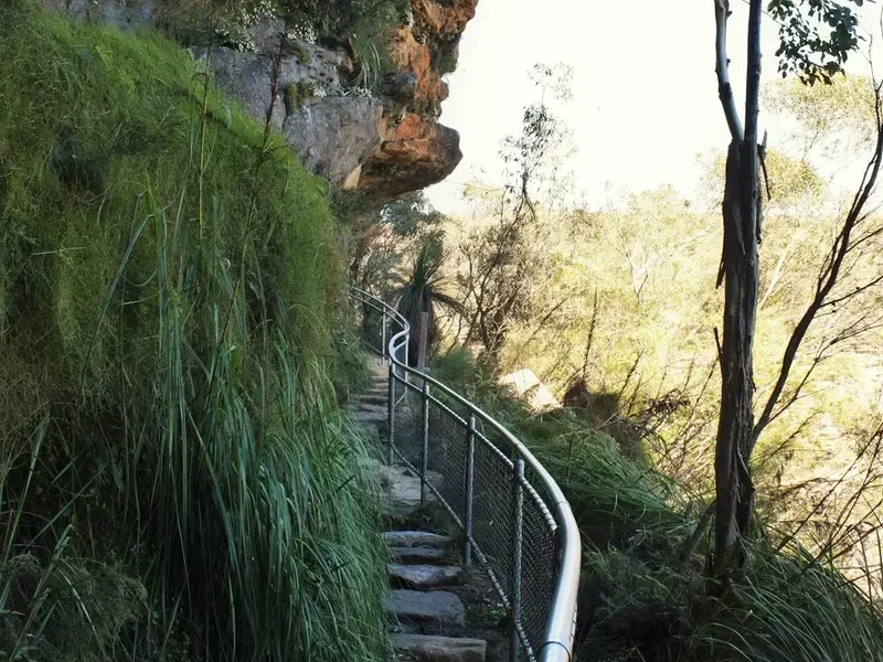
The Mount Bogong Staircase Spur track is a formidable ascent, a true test of physical and mental fortitude. Beginning at the Mountain Creek Picnic Area, the trail immediately plunges into a steep climb, earning its "Staircase" moniker with a relentless series of rock steps and inclines that ascend over 1500 metres in just over 10 kilometres. The initial stages wind through dry sclerophyll forests, dominated by eucalyptus species, where the air can be warm and the terrain demanding. As you gain altitude, the vegetation gradually transitions. The forest becomes denser, with more ferns and mosses appearing, indicating a cooler, moister environment. This change in flora is a welcome indicator of progress and a sign that you are entering the subalpine zone.
The halfway point often feels like a significant achievement, but the climb continues with unwavering determination. The trail can be exposed in sections, offering glimpses of the surrounding valleys and the vastness of the Victorian Alps. The final push towards the summit plateau involves navigating through more open alpine heath and tussock grasslands. The summit itself, marked by a cairn, provides a spectacular 360-degree vista. On a clear day, you can see Mount Kosciuszko in New South Wales, Mount Hotham, and the vast expanse of the Alpine National Park. The descent, while often easier on the lungs, is equally taxing on the knees and requires careful footing due to the steepness and the presence of loose rocks.
This walk is not for the faint-hearted. It demands a high level of cardiovascular fitness, strong leg muscles, and the ability to sustain effort for many hours. Proper preparation, including adequate hydration, nutrition, and appropriate gear, is paramount for a safe and enjoyable experience. The reward for this effort is immense: a profound sense of accomplishment, stunning natural beauty, and an unparalleled perspective of Victoria's highest country.
History and Cultural Context
Mount Bogong has a long and significant history, deeply intertwined with the Indigenous peoples of the region, particularly the Dhudhuroa and Waywurru peoples, who have known and utilised this mountain for millennia. For these communities, Mount Bogong, or "Bargong" in some dialects, was a place of spiritual importance and a vital source of resources. Traditional pathways traversed the mountain, connecting different tribal territories and facilitating seasonal movements for hunting, gathering, and ceremony. The mountain's prominent position in the landscape made it a natural landmark and a focal point for cultural practices. Evidence of this long-standing connection can be found in the landscape, though much of it is subtle and requires careful observation and respect.
European settlement in the late 19th and early 20th centuries brought a new era of interaction with Mount Bogong. Pastoralists began to graze their sheep on the high plains, and the mountain became a destination for adventurous individuals seeking to explore the rugged Australian Alps. The development of tracks, including the Staircase Spur, was often driven by the need for access for these activities, as well as by the burgeoning interest in mountaineering and bushwalking. Early explorers and surveyors documented the challenging terrain and the unique alpine environment, contributing to the growing appreciation for the mountain's natural values.
During the gold rushes and subsequent periods of resource exploration, the region around Mount Bogong saw increased human activity. While the mountain itself was not a primary mining site, its proximity to areas of interest meant it was traversed by prospectors and stockmen. The establishment of the Alpine National Park in 1989, which encompasses Mount Bogong, solidified its status as a protected natural area, safeguarding its ecological and cultural heritage for future generations. Today, the Staircase Spur track stands as a testament to both the natural grandeur of the mountain and the human endeavour to explore and connect with this wild landscape.
Seasonal Highlights and Weather Reality
The Mount Bogong Staircase Spur track is a year-round destination, but each season presents distinct challenges and rewards. Understanding these variations is crucial for planning a safe and enjoyable hike.
Late Spring, Summer, and Early Autumn (October to April): This is generally considered the prime season for tackling the Staircase Spur. The weather is typically milder, with longer daylight hours, making it ideal for a full-day ascent. Wildflowers bloom in the alpine meadows, adding splashes of colour to the landscape. However, even in summer, the weather can change rapidly. Afternoon thunderstorms are common in the Australian Alps, bringing heavy rain, lightning, and a significant drop in temperature. Hikers must be prepared for all conditions, including sunshine, wind, and rain, even on the same day.
Autumn (March to May): This period offers crisp air, clear skies, and stunning autumn colours as the alpine vegetation turns golden and russet. The insect population, including the notorious March flies, tends to decrease. However, temperatures begin to drop, and early snowfalls can occur on the higher reaches of the mountain, especially towards the end of autumn. Hikers should be prepared for colder conditions and potentially icy patches on the track.
Winter (June to August): Winter transforms Mount Bogong into a serious alpine environment. The Staircase Spur track becomes a challenging snow and ice route, requiring advanced mountaineering skills, including the use of an ice axe, crampons, and avalanche safety knowledge. Snow can lie deep on the ground, and visibility can be severely reduced by blizzards. Only experienced winter hikers with appropriate gear and training should consider attempting this track during winter. The Mountain Creek Picnic Area may also be inaccessible due to snow.
Early Spring (September to October): While the snow begins to melt, early spring can still present challenging conditions. Patches of snow and ice may linger on the track, particularly in shaded gullies and at higher elevations. The weather can be unpredictable, with a mix of sunshine, rain, and even late snowfalls. Hikers should exercise caution and be prepared for winter-like conditions.
Regardless of the season, always check the weather forecast before you go and be prepared for rapid changes. The summit of Mount Bogong is exposed and can experience harsh conditions even when the valleys below are calm.
Recommended Itinerary

Mount Bogong Staircase Spur - Day Walk Itinerary
Early Morning (Approx. 6:00 AM - 7:00 AM): Departure from Mount Beauty
- Drive from Mount Beauty to Mountain Creek Picnic Area (approx. 30-45 minutes).
- Ensure you have all necessary gear, food, and water.
- Final check of weather forecast if possible.
Morning (Approx. 7:00 AM - 12:00 PM): Ascent - Mountain Creek to Bivouac Hut
- Start: Mountain Creek Picnic Area (1100 m)
- Distance: ~10.5 km
- Elevation Gain: ~1100 m
- Time: 5–6 hours
- Begin the steep ascent via the Staircase Spur track.
- Navigate numerous rock steps and inclines through dry sclerophyll forest.
- Pass through transition zones as vegetation changes to denser woodland.
- Take short breaks for hydration and snacks.
- Reach Bivouac Hut (approx. 2100 m) – a basic shelter offering a place to rest and refuel.
Midday (Approx. 12:00 PM - 2:00 PM): Summit Push - Bivouac Hut to Summit
- Distance: ~1.5 km
- Elevation Gain: ~441 m
- Time: 1–1.5 hours
- Continue the climb from Bivouac Hut towards the summit plateau.
- The terrain becomes more open, transitioning to alpine heath and tussock.
- Be aware of changing weather conditions and increased wind exposure.
- Reach the summit cairn (1545 m).
Afternoon (Approx. 2:00 PM - 3:00 PM): Summit Experience and Lunch
- Enjoy the panoramic views from the summit.
- Have lunch and rehydrate.
- Take photographs and appreciate the accomplishment.
- Begin descent preparations.
Late Afternoon (Approx. 3:00 PM - 7:00 PM): Descent - Summit to Mountain Creek Picnic Area
- Distance: ~12 km
- Elevation Loss: ~1541 m
- Time: 3–4 hours
- Descend carefully via the Staircase Spur track.
- Pay close attention to footing, especially on steep sections and loose scree.
- Continue through the changing vegetation zones.
- Arrive back at Mountain Creek Picnic Area.
Evening (Approx. 7:00 PM onwards): Return to Mount Beauty
- Drive back to Mount Beauty.
- Celebrate your achievement!
Important Notes:
- This is a strenuous day walk requiring excellent fitness.
- Start early to allow ample time and avoid afternoon thunderstorms.
- Carry sufficient water (at least 3 litres per person) and high-energy food.
- Be prepared for rapid weather changes; carry full waterproofs and warm layers.
- The track can be slippery and hazardous after rain or snow.
- Mobile phone reception is unreliable; consider a personal locator beacon (PLB).
Planning and Bookings
Book Your Trip
Everything you need to plan your journey
Accommodation
Find places to stay near Mount Beauty
Flights
Search flights to Mount Beauty
Essential Preparation
Undertaking the Mount Bogong Staircase Spur walk requires meticulous planning due to its challenging nature and the potential for unpredictable alpine weather. Before embarking, ensure you have a high level of physical fitness. This walk involves a significant elevation gain of over 1500 metres, demanding strong cardiovascular endurance and leg strength. Familiarise yourself with the route using maps and GPS devices, as mobile phone reception is unreliable in the area. The closest town for supplies and accommodation is Mount Beauty. It offers essential services, including supermarkets, outdoor gear shops, and various accommodation options ranging from caravan parks to motels. Albury Airport (ABX) is the nearest major airport, approximately a two-hour drive from Mount Beauty. Access to the trailhead at Mountain Creek Picnic Area is via Bogong High Plains Road, which is paved but can be narrow and winding. It's advisable to check road conditions, especially outside of summer, as snow can affect accessibility.
Trail Accommodation
This is a day hike requiring no overnight accommodation.
Required Gear
- Sturdy Hiking Boots: Waterproof, with good ankle support and a well-worn tread. Essential for navigating the steep, rocky, and potentially slippery terrain.
- Backpack: A comfortable daypack (25-35 litres) to carry essentials. Ensure it has a good hip belt for stability.
- Waterproof Jacket and Trousers: Essential for protection against rain and wind, which can change rapidly in alpine environments.
- Warm Layers: Including a fleece or down jacket, thermal base layers, and a beanie. Temperatures can drop significantly, especially at higher altitudes and in windy conditions.
- Navigation Tools: A detailed topographic map of the area, a compass, and a GPS device or smartphone with offline maps. Know how to use them.
- Head Torch: With spare batteries. Even if planning to finish before dark, an early start or unexpected delays can mean hiking in low light.
- First-Aid Kit: Comprehensive kit including blister treatment, pain relievers, antiseptic wipes, bandages, and any personal medications.
- Sun Protection: High SPF sunscreen, sunglasses, and a wide-brimmed hat. The sun can be intense at higher altitudes, even on cloudy days.
- Insect Repellent: Particularly important during warmer months to ward off flies and mosquitoes.
- Emergency Shelter: A lightweight emergency blanket or bivvy bag for unexpected situations.
What to Bring
- Food: High-energy, non-perishable food for the entire day. This includes breakfast, lunch, and plenty of snacks (e.g., trail mix, energy bars, fruit, sandwiches). You will be exerting a lot of energy.
- Water: Carry at least 3 litres of water per person. There are no reliable water sources on the upper sections of the track, and any water found should be treated.
- Water Treatment: A water filter or purification tablets as a backup or for refilling if you find a suitable source lower down.
- Toiletries: Small personal items such as hand sanitiser, toilet paper, and any personal hygiene products. Pack out all used toilet paper.
- Trekking Poles: Highly recommended for reducing strain on knees during the steep ascent and descent.
- Mobile Phone: Fully charged, for emergency use if reception is available. Consider a portable power bank.
- Personal Locator Beacon (PLB): Strongly recommended for remote areas with unreliable mobile coverage. These can be hired from various outdoor stores.
- Small Knife or Multi-tool: Useful for various minor tasks.
- Camera: To capture the stunning scenery.
Permits
For day walks on Mount Bogong via the Staircase Spur track, no specific permits are generally required for individuals or small groups. However, it is always advisable to check the official Parks Victoria website for any updates or specific regulations that may be in place. Parks Victoria manages the Alpine National Park, and while general access is free, there can be specific rules regarding group sizes, camping (though not applicable for this day walk), or fire restrictions, especially during periods of high fire danger.
Key Considerations:
- Fire Restrictions: Always be aware of current fire bans and restrictions. Campfires are generally prohibited in the Alpine National Park, and the use of stoves may also be restricted during extreme fire danger periods.
- Group Size: While not typically regulated for day walks, very large groups might consider informing Parks Victoria for safety and management purposes.
- Vehicle Access: Ensure your vehicle is suitable for the road conditions leading to the trailhead. Bogong High Plains Road is paved but can be narrow and winding.
- Parks Victoria Website: Regularly check the Parks Victoria website for the latest information on track conditions, alerts, closures, and any changes to access regulations. This is the most reliable source for up-to-date information.
The focus for this walk is on preparedness and responsible recreation rather than obtaining formal permits. Ensure you have the necessary gear, knowledge, and fitness to safely complete the challenging ascent and descent.
Other Activities in the Area
The region surrounding Mount Bogong offers a variety of activities for those looking to extend their stay or explore beyond the summit hike:
- Exploring Mount Beauty: The charming town of Mount Beauty provides a relaxed atmosphere with local cafes, shops, and galleries. It's a great place to unwind after a strenuous hike.
- High Country Drives: The Bogong High Plains Road itself offers spectacular scenic drives with numerous lookouts and opportunities to explore other walking tracks and historical sites like the Bogong Village.
- Lake Hume and Lake Dartmouth: These large reservoirs offer opportunities for water sports, fishing, and scenic picnics.
- Mount Buffalo National Park: A short drive away, Mount Buffalo offers different geological formations, waterfalls, and a range of walking tracks suitable for various fitness levels.
- Cycling: The roads and trails around Mount Beauty and the High Plains are popular with cyclists, offering both challenging road climbs and off-road mountain biking opportunities.
- Fishing: The Kiewa River and surrounding streams provide opportunities for trout fishing.
- Stargazing: The clear, unpolluted skies of the high country offer exceptional stargazing opportunities.
Safety and Conditions
Pre-Departure Checks:
- Weather Forecast: Always check the Bureau of Meteorology (BOM) forecast for the Mount Bogong summit and surrounding high country before you depart. Pay close attention to temperature, wind speed, and precipitation. Be aware that alpine weather can change rapidly and drastically.
- Track Conditions: Consult the Parks Victoria website for any alerts or closures related to the Staircase Spur track or the Alpine National Park.
- Road Conditions: Check VicTraffic for any road closures or advisories affecting Bogong High Plains Road.
- Personal Locator Beacon (PLB): Given the remoteness and potential for unreliable mobile reception, carrying a PLB is highly recommended. Ensure it is registered and you know how to operate it.
On the Trail:
- Start Early: Begin your hike as early as possible to allow ample time to reach the summit and return before dark, and to avoid the risk of afternoon thunderstorms.
- Stay on the Track: The Staircase Spur is well-defined, but in poor visibility, it's crucial to stay on the marked path to avoid getting lost.
- Hydration and Nutrition: Drink water regularly and eat high-energy snacks throughout the hike to maintain stamina and prevent fatigue.
- Pace Yourself: The ascent is steep and demanding. Take regular short breaks to rest, hydrate, and refuel.
- Be Prepared for All Conditions: Even on a warm day, the summit can be cold and windy. Carry adequate warm clothing and waterproofs.
- Hypothermia Risk: Be aware of the symptoms of hypothermia (shivering, confusion, drowsiness) and take immediate action if they occur.
- Lightning: If thunderstorms threaten, descend immediately. Avoid exposed ridges, summits, and isolated trees. Seek shelter in a vehicle or a substantial building if possible.
- Insect Bites: During warmer months, be prepared for flies and mosquitoes.
- Footwear: Ensure your boots are well-fitted and provide adequate support. Blisters can significantly impact your ability to complete the hike.
- Inform Someone: Let a reliable person know your hiking plans, including your intended route, estimated return time, and who to contact if you don't check in.
Emergency Contact: In case of emergency, call Triple Zero (000) if you have mobile reception. Otherwise, activate your PLB.
Side Trips and Points of Interest
Bivouac Hut: Located approximately halfway up the Staircase Spur, Bivouac Hut is a basic, unserviced shelter. It provides a welcome respite from the steep climb and offers a place to rest, have lunch, and assess your progress. While not a luxury facility, it's a crucial landmark and a good point to check your water and food supplies before the final push to the summit.
Summit Plateau Views: The summit of Mount Bogong offers unparalleled 360-degree views across the Victorian Alps. On a clear day, you can see as far as Mount Kosciuszko to the north-east and Mount Hotham to the south. The vastness of the Alpine National Park unfolds before you, a breathtaking panorama of rolling hills, rugged peaks, and deep valleys. This expansive vista is the ultimate reward for the strenuous climb.
Alpine Flora and Fauna: As you ascend, you'll notice the distinct changes in vegetation. The lower slopes are dominated by dry eucalyptus forests, transitioning to more temperate woodlands with ferns and mosses, and finally to open alpine heath and tussock grasslands near the summit. Keep an eye out for native wildlife, including various bird species, kangaroos, and wallabies, particularly in the early morning or late afternoon.
Bogong High Plains Road Lookouts: The drive to the trailhead along Bogong High Plains Road offers several scenic lookouts with impressive views of the surrounding mountain ranges and valleys. These are excellent spots for a brief stop to appreciate the scale of the landscape you are about to explore.
Leave No Trace
The Mount Bogong Staircase Spur track traverses a sensitive alpine environment within the Alpine National Park. Adhering to Leave No Trace principles is paramount to preserving this fragile ecosystem for future generations. Your actions directly impact the natural beauty and ecological integrity of this area.
Your responsibility as a hiker:
- Plan Ahead and Prepare: Understand the trail, weather conditions, and your own capabilities. Pack appropriate gear and sufficient food and water.
- Travel and Camp on Durable Surfaces: Stick to the marked Staircase Spur track. Avoid creating new paths or walking on fragile alpine vegetation, which can take decades to recover. If camping were permitted (which it is not on this day walk), you would camp on established sites or durable surfaces.
- Dispose of Waste Properly: Pack out everything you pack in. This includes all food scraps, wrappers, and any other litter. Use designated toilet facilities where available, or if not, dig a cathole at least 70 metres away from water sources, trails, and campsites, and bury human waste. Pack out all toilet paper.
- Leave What You Find: Do not remove or disturb natural objects such as rocks, plants, or flowers. Take only photographs and memories.
- Minimise Campfire Impacts: Campfires are generally prohibited in the Alpine National Park. If using a stove, ensure it is a lightweight, portable one and use it on a durable surface away from flammable materials.
- Respect Wildlife: Observe wildlife from a distance. Do not feed animals, as this can disrupt their natural behaviours and diets, and can be harmful to their health.
- Be Considerate of Other Visitors: Keep noise levels down and yield to other hikers on the trail.
By following these principles, you help ensure that the Mount Bogong Staircase Spur remains a wild and beautiful place for everyone to enjoy.