Mount Batur Sunrise Trek - A Journey to Bali's Volcanic Heart
Mount Batur, or Gunung Batur, is an active double caldera volcano located in the Kintamani region of northeastern Bali, Indonesia. Rising to an elevation of 1,717 metres above sea level, it is one of the island's most iconic natural landmarks and a site of profound spiritual significance to the Balinese people. The Mount Batur Sunrise Trek is widely considered the premier hiking experience in Bali, offering a relatively accessible yet physically rewarding ascent that culminates in a breathtaking panoramic view of the sun rising over the Lombok Strait, with the silhouettes of Mount Abang and the mighty Mount Agung framed against the morning sky. This 11-kilometre round trip takes walkers through a diverse landscape of volcanic ash, rugged lava flows, and dense tropical vegetation, providing an intimate encounter with the raw geological forces that have shaped the "Island of the Gods."
- Distance: 11.0 km return
- Duration: 4–5 hours
- Season: Dry season (April to October) is optimal for clear sunrise views
- Difficulty: Moderate (requires a reasonable level of cardiovascular fitness)
- Highest point: 1,717 metres (Summit Crater)
- Elevation Gain: 700 metres
- Location: Kintamani, Bali, Indonesia
Overview
The Mount Batur Sunrise Trek is a masterclass in atmospheric pacing. The journey typically begins in the profound stillness of the pre-dawn hours, usually between 03:30 and 04:00, as hikers set off from the base at Pura Jati or Toya Bungah. Under a canopy of stars, the trail winds upwards through local farmlands where the scent of shallots and tomatoes fills the cool night air, before transitioning into the steeper, more challenging terrain of the volcanic cone. The ascent is a sensory experience defined by the rhythmic crunch of volcanic gravel underfoot and the flickering line of headlamps snaking up the mountainside, creating a shared sense of purpose among the international community of trekkers.
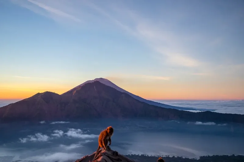
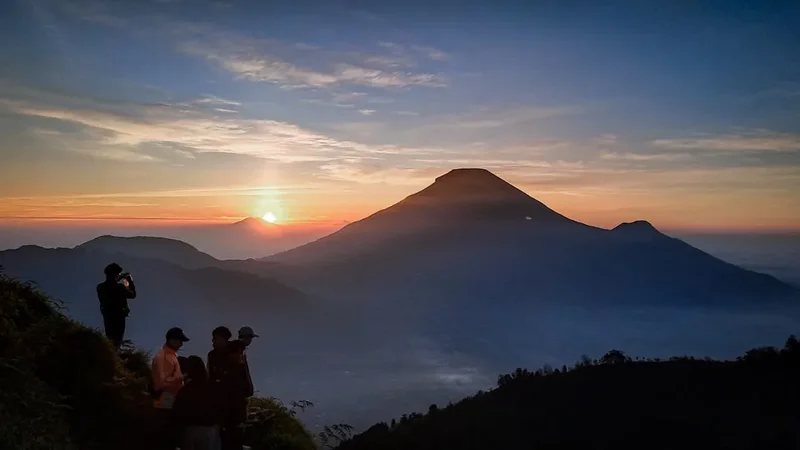
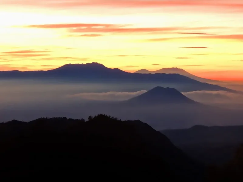
As you reach the summit ridge, the reward is immediate and humbling. To the east, the sky begins to transition through a spectrum of deep indigo, violet, and fiery orange. Below, the vast crescent of Lake Batur—the largest crater lake in Bali—shimmers in the twilight, while the surrounding caldera walls, some 13 kilometres in diameter, provide a dramatic sense of scale. On clear mornings, the view extends across the sea to the neighbouring island of Lombok, where the peak of Mount Rinjani can often be seen piercing the horizon. The summit area itself is a hive of gentle activity; steam rises from active volcanic vents, and the local long-tailed macaques emerge to greet the morning sun, often hoping for a share of the traditional "volcano breakfast" cooked using the mountain's natural geothermal heat.
Beyond the visual spectacle, Mount Batur is a UNESCO Global Geopark, recognised for its exceptional geological heritage and the unique "Tri Hita Karana" philosophy that governs the relationship between the local people, their environment, and the divine. Walking this trail is not merely a physical exercise but an immersion into a landscape where mythology and geology are inextricably linked. Whether you are standing on the rim of the active crater or traversing the expansive black lava fields from the 1963 eruption, the Mount Batur trek offers a profound connection to the earth's primordial energy, making it an essential pilgrimage for any nature lover visiting Bali.
History and Cultural Context
The geological history of Mount Batur is a saga of cataclysmic events and rebirth. The current landscape is dominated by two massive calderas. The outer caldera, measuring approximately 10 by 13 kilometres, was formed during a colossal eruption over 29,000 years ago. A second, inner caldera was created roughly 20,000 years ago, within which the current 1,717-metre cone sits. In modern history, Mount Batur has remained one of Indonesia's most active volcanoes, with over 20 significant eruptions recorded since 1804. The most devastating of these occurred in 1917 and 1926, which claimed thousands of lives and destroyed numerous villages, including the original site of the Pura Ulun Danu Batur temple. The 1963 eruption, which coincided with the massive eruption of nearby Mount Agung, left behind the vast, haunting "Black Lava" fields that trekkers can still explore today on the mountain's western flanks.
Culturally, Mount Batur is considered one of the "Sad Kahyangan"—the six holiest places of worship in Bali. It is dedicated to Dewi Danu, the goddess of the lake and the provider of water for the island's intricate "subak" irrigation system. The Balinese believe that the volcano and its lake are the source of life-giving water that sustains the rice terraces across the central and southern regions. Consequently, the mountain is a site of frequent ceremonies and offerings. Hikers will often notice small "canang sari" (palm-leaf baskets filled with flowers and incense) placed at the summit and along the trail, serving as a reminder that this is a sacred space. The resilience of the local Kintamani people, who have rebuilt their lives and temples multiple times in the shadow of the volcano, adds a layer of human depth to the trekking experience.
Want more background? Read extended notes on history and cultural context → Learn more
Seasonal Highlights and Weather Reality
Bali's tropical climate means that the Mount Batur Sunrise Trek is technically possible year-round, but the experience varies significantly between the dry and wet seasons. The dry season, running from April to October, is the peak period for trekking. During these months, the probability of a clear, unobstructed sunrise is at its highest, and the trail conditions are generally stable. However, this is also the busiest time, and the summit can become quite crowded, particularly in July and August. Temperatures at the summit during the dry season can be surprisingly chilly, often dropping to between 10°C and 15°C before sunrise, necessitating warm layers despite the tropical heat at sea level.
The wet season, from November to March, brings frequent afternoon and evening rain, though mornings can often remain clear. Trekking during this period requires more flexibility and a keen eye on weather forecasts. The primary challenge during the wet season is the trail surface; the volcanic ash and gravel can become extremely slippery and muddy when saturated, making the descent particularly treacherous. Cloud cover is also more common, which can obscure the sunrise, though the sight of mist swirling through the caldera can be incredibly atmospheric. The advantage of the wet season is the lush, vibrant green of the surrounding vegetation and the significantly smaller crowds, offering a more solitary and peaceful experience for those willing to risk the rain.
Recommended Itinerary

Mount Batur Sunrise Trek Itinerary
Early Morning: The Ascent (01:30 – 05:30)
- 01:30 – 02:30: Pickup from your accommodation in Ubud, Canggu, or Seminyak. The drive to Kintamani takes between 1 and 2.5 hours depending on your location.
- 03:30: Arrival at the starting point (usually Pura Jati or Toya Bungah). Meet your local guide, receive your headlamp, and begin the trek.
- 03:30 – 04:30: The first hour of the trek is a gradual incline through local plantations and forested areas. This is a good time to find your rhythm and adjust to the darkness.
- 04:30 – 05:30: The trail becomes steeper and more rugged as you ascend the volcanic cone. The terrain shifts to loose volcanic scree and rock. Several rest stops are usually taken to hydrate and catch your breath.
- 05:30: Reach the summit crater rim (1,717 m) just as the first light begins to appear on the horizon.
Morning: The Summit Experience (05:30 – 07:30)
- 05:30 – 06:15: Find a comfortable spot on the rim to watch the sunrise. Your guide will typically begin preparing a simple breakfast.
- 06:15 – 06:45: Enjoy breakfast (often including eggs and bananas steamed in volcanic vents, bread, and Balinese coffee or tea) while the sun rises over Mount Agung and Mount Abang.
- 06:45 – 07:30: Explore the summit area. Walk along the crater rim to see the active steam vents and the deep inner crater. This is the best time for photography as the light is soft and the views are expansive.
- Interact with the local macaques (keep your food secured!) and observe the small shrines at the peak.
Midday: The Descent and Return (07:30 – 11:00)
- 07:30 – 09:00: Begin the descent. You may choose to take a different route down that passes through the 1963 black lava fields or follow the main trail back. The descent requires focus as the loose gravel can be slippery.
- 09:00: Arrive back at the trailhead. Say goodbye to your guide and board your transport.
- 09:30 – 10:30: Optional stop at a local coffee plantation (Luwak coffee) or the Batur Natural Hot Springs to soak tired muscles.
- 11:00 – 12:30: Return to your accommodation for a well-earned rest.
Important Notes:
- The trek is a loop or out-and-back depending on the specific guide and starting point.
- Total walking time is approximately 4 hours, but the entire excursion from pickup to drop-off is roughly 8–10 hours.
- The pace is generally dictated by the group, but guides are excellent at managing different fitness levels.
- Always follow your guide's instructions, especially near the crater rim where the ground can be unstable.
Planning and Bookings
Book Your Trip
Everything you need to plan your journey
Accommodation
Find places to stay near Ubud
Flights
Search flights to Ubud
Essential Preparation
While Mount Batur is often described as a "beginner-friendly" trek, it should not be underestimated. The 700-metre elevation gain over a relatively short distance requires a moderate level of cardiovascular fitness. If you are not accustomed to hiking on loose, uneven terrain, your calf muscles and knees will certainly feel the effort. It is highly recommended to spend at least two days in Bali prior to the trek to acclimatise to the tropical humidity, even though the mountain air is much cooler.
Logistically, most trekkers base themselves in Ubud, which is approximately 1 to 1.5 hours from the trailhead. Booking a guided tour is the standard and most efficient way to experience Mount Batur. These tours typically include door-to-door transport, a local guide (mandatory by local custom), breakfast, and trekking equipment like headlamps and walking poles. It is essential to book your trek at least 24–48 hours in advance, especially during the peak dry season. Coordination with your driver regarding pickup times is crucial, as a late start can mean missing the sunrise.
Trail Accommodation
This is a day hike requiring no overnight accommodation on the mountain itself. Camping on the summit is generally discouraged and rarely practiced due to the early start times and the efficiency of the sunrise trekking model. However, for those who wish to minimise their morning travel time, there are several accommodation options in the Kintamani and Toya Bungah areas.
Local Options:
- Guesthouses and Homestays: Numerous budget-friendly guesthouses are located in Toya Bungah, right at the base of the volcano. Staying here allows for an extra hour of sleep, as you can walk directly to the trailhead at 03:30.
- Lakeside Resorts: There are several mid-range resorts along the shores of Lake Batur that offer spectacular views of the volcano and easy access to the hot springs.
- Glamping: In recent years, several "glamping" sites have opened on the outer caldera rim, providing a more luxurious way to stay close to the action.
Most trekkers choose to stay in Ubud or the southern beach towns and use the provided transport, as the facilities on the mountain are limited to basic shelters and small stalls (warungs) selling tea and snacks at the summit.
Required Gear
- Footwear: Sturdy trainers with good grip are the minimum requirement. Proper hiking boots with ankle support are highly recommended due to the loose volcanic scree and steep descent.
- Clothing Layers: A moisture-wicking base layer, a warm mid-layer (fleece or light down jacket), and a windproof outer shell. It is cold at the summit before dawn but will heat up rapidly once the sun rises.
- Headlamp: Essential for the night ascent. Most guides provide these, but bringing your own high-quality LED headlamp ensures better visibility.
- Small Backpack: A 10–20L pack to carry your water, layers, and camera.
- Walking Poles: Extremely helpful for the descent to save your knees on the slippery gravel.
What to Bring
- Water: At least 1.5 to 2 litres per person. While some guides provide a small bottle, it is often insufficient for the full trek.
- Snacks: While breakfast is usually provided, having some energy gels, nuts, or chocolate can provide a necessary boost during the steep final ascent.
- Sun Protection: Sunscreen (SPF 50+), sunglasses, and a hat. The tropical sun is intense at high altitudes, even if it feels cool.
- Personal First Aid: Plasters for blisters, any personal medications, and hand sanitiser.
- Camera/Smartphone: With fully charged batteries and spare memory. The photography opportunities are world-class.
- Cash: Small denominations of Indonesian Rupiah (IDR) for tipping your guide or buying extra drinks at the summit warungs.
- Toilet Paper/Tissues: Facilities on the mountain are extremely basic (squat toilets at the base and mid-point).
Permits
The regulatory environment for trekking Mount Batur is unique and managed by the Association of Mount Batur Trekking Guides (Himpunan Pramuwisata Pendaki Gunung Batur - HPPGB). While there is no formal government "permit" in the style of a national park pass that you must apply for weeks in advance, there are mandatory fees and local customs that must be respected.
Key Information:
- Mandatory Guides: Local regulations strongly dictate that all trekkers must be accompanied by a licensed local guide. This is a community-led initiative to ensure safety and provide employment for the local Kintamani villages. Attempting to hike without a guide is highly discouraged and often leads to confrontations with local associations at the trailhead.
- Entrance Fees: There is a Kintamani regional entrance fee (Retribusi) collected at checkpoints on the road into the caldera. This is approximately IDR 50,000 per person.
- Trekking Fees: If you book a tour, the guide fee and "permit" to climb are usually included in the total price. If you arrive independently, you will be required to hire a guide at the HPPGB office at the trailhead, which typically costs between IDR 500,000 and IDR 700,000 for a group of up to four people.
- Booking Strategy: The easiest way to handle permits and fees is to book an all-inclusive tour through a reputable operator in Ubud or online. This ensures all local "contributions" and entrance fees are handled, allowing you to focus on the hike.
Costs (Estimated):
- All-inclusive tour from Ubud: IDR 600,000 – IDR 900,000 per person (depending on group size and inclusions).
- Independent guide hire at trailhead: IDR 500,000+ per group.
- Kintamani area entrance: IDR 50,000 per person.
Other Activities in the Area
The Kintamani region offers several excellent ways to relax and explore after your trek:
- Batur Natural Hot Springs: Located in Toya Bungah on the edge of the lake, these geothermal pools are the perfect remedy for sore muscles. Soaking in the warm, mineral-rich water while looking back up at the volcano you just climbed is a highlight for many.
- Lake Batur Boat Tours: Hire a local boat to explore the lake and visit the "Trunyan" village on the eastern shore, famous for its unique burial customs where the deceased are placed under a sacred tree rather than cremated or buried.
- Pura Ulun Danu Batur: Visit the rebuilt temple dedicated to the goddess of the lake. It is one of Bali's most important and beautiful temple complexes, featuring impressive multi-tiered "meru" towers.
- Coffee Plantations (Satria or similar): Most return trips to Ubud include a stop at a coffee plantation. You can learn about the process of making Luwak coffee and sample various Balinese teas and infusions.
- Cycling Tours: Many operators offer downhill mountain biking tours that start in Kintamani and wind through traditional villages and rice paddies toward Ubud.
Safety and Conditions
Volcanic Activity: Mount Batur is an active volcano. While it is closely monitored by the Indonesian Centre for Volcanology and Geological Hazard Mitigation (PVMBG), conditions can change. Always check the current alert level before heading out. If the volcano shows signs of increased activity, the trail will be closed to the public.
Terrain Hazards: The most common injuries on Mount Batur occur during the descent. The volcanic ash is extremely fine and acts like ball bearings on hard rock. It is very easy to slip and twist an ankle or graze a knee. Take your time, use walking poles, and follow the path suggested by your guide. Avoid standing too close to the edge of the inner crater, as the rim can be unstable and prone to erosion.
Temperature and Exposure: Hypothermia is a minor but real risk for those who arrive at the summit early and are underdressed. The combination of sweat from the climb and the cold wind at 1,717 metres can lead to rapid cooling. Ensure you have a dry layer to change into or a warm jacket to put on as soon as you stop moving. Conversely, once the sun is up, heat exhaustion becomes the primary concern; stay hydrated and use sun protection.
Wildlife: The macaques at the summit are habituated to humans and can be aggressive if they smell food. Keep your backpack zipped, do not feed them, and avoid making direct eye contact, which they perceive as a challenge.
Sulphur Fumes: Near the active vents, you may encounter the smell of rotten eggs (hydrogen sulphide). While generally harmless in small quantities in open air, those with respiratory issues like asthma should be cautious and avoid leaning directly over the vents.
Side Trips and Points of Interest
The 1963 Black Lava Fields: On the western side of the volcano lies a vast expanse of frozen basaltic lava from the 1963 eruption. This "moonscape" is a stark contrast to the lush greenery of the rest of Bali. Many guides can take you on a detour through these fields on the way down, where you can see the incredible patterns formed by the cooling magma and the pioneering plants beginning to recolonise the rock.
The Inner Crater Vents: Just below the main summit rim, there are several deep fissures where volcanic steam escapes. Guides often use these to demonstrate the mountain's heat by "cooking" eggs or bananas in the steam. It is a fascinating reminder of the geological engine beneath your feet.
Mount Abang: For those seeking a more challenging and less crowded experience, Mount Abang (2,152 m) sits directly across the lake on the outer caldera rim. The trail is more forested and offers a spectacular "reverse" view of Mount Batur with the lake in the foreground.
Pura Jati: The temple at the base of the mountain near the lake is often the starting point for the trek. It is a beautiful example of Balinese architecture and provides a peaceful place for reflection before or after the physical exertion of the climb.
Leave No Trace
As a UNESCO Global Geopark and a sacred site, Mount Batur requires the highest level of environmental respect. The sheer volume of daily trekkers (sometimes over 500 people in a single morning) puts immense pressure on the ecosystem. Waste management is a significant challenge in the region, and every hiker must play their part in preserving the mountain's beauty.
Your Responsibility:
- Pack it in, Pack it out: Take all your rubbish back down the mountain, including organic waste like banana peels or eggshells, which can take a long time to decompose in the dry volcanic soil and attract pests.
- Stay on the Trail: Short-cutting switchbacks causes significant erosion on the steep volcanic slopes and destroys the limited vegetation that manages to grow there.
- Respect the Sacred: Do not touch or move offerings (canang sari) and dress modestly at the base temples.
- No Graffiti: Never carve names or symbols into the volcanic rocks or trees.
- Water Conservation: Use water sparingly and avoid contaminating the lake or local streams with soaps or chemicals.
- Support Local: By hiring a local guide, you are contributing to the local economy, which in turn incentivises the community to protect the mountain.