
Mount Bartle Frere Trail - Queensland's Highest Peak
The Mount Bartle Frere Trail is a challenging ascent to the summit of Queensland's highest mountain, standing at 1,622 metres above sea level. Located in the Wooroonooran National Park, near Cairns in Far North Queensland, this track offers a demanding, multi-day adventure through diverse tropical rainforest ecosystems, culminating in a rugged, exposed alpine environment. The trail is renowned for its steep gradients, variable weather conditions, and the significant physical effort required to reach the summit. It is a journey that tests endurance and rewards hikers with breathtaking panoramic views of the surrounding Atherton Tablelands and coastal plains on clear days. Due to its difficulty and the need for overnight stays, it is considered a very challenging hike, suitable only for experienced and well-prepared trekkers.
- Distance: 15.0 km one-way
- Elevation gain: 1,622 m
- Duration: 2 days / 1 night
- Difficulty: Very Challenging
- Best Time: May to September (cooler, drier season)
- Huts: No designated huts; camping is permitted at designated campsites (e.g., Windinara campsite)
- Highest point: 1,622 m
- Daily walkers: No daily limit, but self-sufficiency is paramount
- Direction: Out and back
Overview
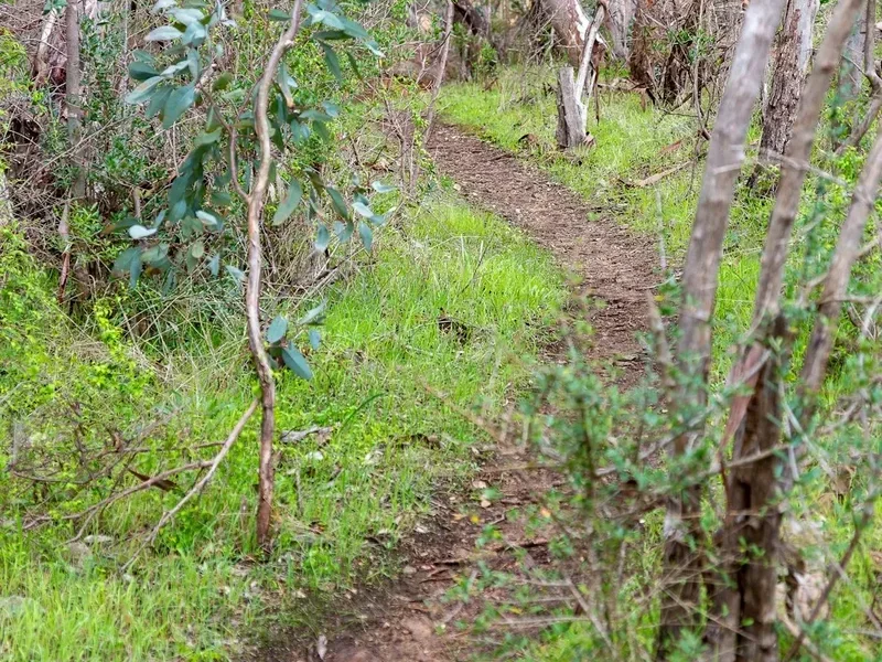
Mount Bartle Frere presents a formidable challenge, a true test of a hiker's physical and mental fortitude. The trail begins at the Josephine Falls car park, a popular spot for day-trippers, but quickly ascends into dense, humid rainforest. The initial stages are characterised by a steep, relentless climb, often on rough, uneven terrain with exposed roots and rocks. As you gain altitude, the vegetation changes, transitioning from lush tropical lowland rainforest to montane rainforest, and eventually to a more open, windswept alpine environment near the summit. The air becomes cooler, and the humidity decreases, but the exposure to the elements increases significantly.
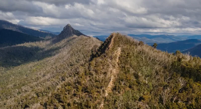
The trail is not well-marked in all sections, and navigation can be tricky, especially in poor visibility. The summit plateau itself is a rocky, exposed area, and reaching the true highest point requires careful scrambling over boulders. The reward for this arduous journey is immense: on a clear day, the views from the summit are spectacular, encompassing the vast expanse of the Wet Tropics World Heritage Area, including the Atherton Tablelands, the Great Dividing Range, and the distant Coral Sea. However, weather on Bartle Frere can change rapidly. Fog, rain, and strong winds are common, even during the dry season, and can reduce visibility to mere metres, making the summit experience a stark and potentially hazardous one. The descent is often as challenging as the ascent, with tired legs and the steep gradient posing a significant risk of slips and falls.
The Mount Bartle Frere Trail is a significant undertaking, requiring a high level of fitness, robust navigation skills, and meticulous planning. It is a journey into a unique and powerful natural environment, offering a profound sense of accomplishment for those who successfully reach its peak.
History and Cultural Context
Mount Bartle Frere holds significant cultural importance for the Traditional Owners, the Indigenous peoples of the region, including the Ngati Maru and Ngati Kori people. For millennia, this mountain has been a sacred place, a source of sustenance, and a significant landmark within their ancestral lands. The rainforests surrounding its base provided abundant resources, and the mountain itself likely played a role in their spiritual beliefs and traditional practices. The name "Bartle Frere" was given by explorer George Elphinstone Dalrymple in 1873, in honour of Sir Bartle Frere, the then Governor of Queensland. Dalrymple was the first European to survey the area, and his naming of the mountain marked the beginning of European exploration and settlement in the region.
The development of the trail itself is a testament to the efforts of early explorers and later, dedicated bushwalkers and conservationists. Initially, access was extremely difficult, with dense rainforest and steep terrain presenting major obstacles. Over time, rudimentary tracks were forged, primarily by adventurous individuals seeking to conquer Queensland's highest peak. These early trails were often poorly marked and required significant bushcraft skills to navigate. In more recent times, the Queensland Parks and Wildlife Service has maintained and improved sections of the track, particularly the lower reaches, to make it more accessible, though it remains a challenging route. The establishment of Wooroonooran National Park in 1988, and its subsequent inclusion in the Wet Tropics World Heritage Area, has helped to protect the unique biodiversity and cultural heritage of Mount Bartle Frere, ensuring its preservation for future generations.
Seasonal Highlights and Weather Reality
The best time to attempt the Mount Bartle Frere Trail is during the cooler, drier months, typically from May to September. This period offers more favourable weather conditions, with lower humidity, less rainfall, and cooler temperatures, making the strenuous climb more manageable. Daytime temperatures can still be warm, but the risk of extreme heat and humidity, common in the wet season, is significantly reduced. Nights can be cool, especially at higher elevations, so warm clothing is essential.
During the wet season (approximately November to April), the trail becomes significantly more challenging and potentially dangerous. Rainfall is heavy and frequent, leading to swollen creeks, slippery track surfaces, and increased risk of landslides. The dense rainforest canopy can become saturated, and waterfalls and cascades along the route become more numerous and powerful. Visibility can be severely reduced by fog and heavy rain, making navigation extremely difficult and increasing the risk of getting lost. The summit can be shrouded in cloud for extended periods, obscuring the views and creating a disorienting environment. While the rainforest is at its most vibrant and lush during this time, the increased hazards make it a less suitable period for most hikers. Even during the dry season, unexpected rain showers and sudden drops in temperature can occur, so it is crucial to be prepared for all conditions at any time of year.
Recommended Itinerary
2-Day Mount Bartle Frere Itinerary
Day 1: Josephine Falls Car Park to Windinara Campsite
- Distance: 7.5 km
- Elevation gain: 900 m
- Time: 5–7 hours
- Start at Josephine Falls car park
- Follow the well-marked track through dense rainforest
- The initial section is a steep, sustained climb with many steps and rough terrain
- Pass through various rainforest zones, observing changes in vegetation
- Cross several small creeks and streams
- Arrive at Windinara campsite (designated camping area)
- Set up camp and prepare for the next day's summit push
- This day focuses on gaining significant altitude through challenging rainforest terrain
Day 2: Windinara Campsite to Summit and Return to Josephine Falls Car Park
- Distance: 7.5 km (to summit and back)
- Elevation gain: 722 m (to summit)
- Time: 6–9 hours (round trip from campsite)
- Early start recommended to maximise daylight and potentially catch clearer summit views
- The track becomes rougher and less defined as you ascend towards the summit plateau
- Navigate through boulder fields and exposed sections
- The final push to the summit requires scrambling over large rocks
- Reach the summit trig point (1,622 m) and enjoy panoramic views (weather permitting)
- Descend carefully back to Windinara campsite
- Pack up camp and continue the descent back to Josephine Falls car park
- This day involves the most challenging terrain and the highest risk of exposure
Important Notes:
- This is a strenuous hike requiring excellent fitness and navigation skills.
- No water is available on the summit; carry sufficient water for the entire trip or be prepared to treat water from creeks (treatment essential).
- Camping is permitted only at designated campsites like Windinara. Bookings may be required through Queensland Parks and Wildlife Service.
- Weather can change rapidly; be prepared for rain, wind, and fog at any time.
- Carry a map, compass, and GPS device, and know how to use them.
- Inform someone of your hiking plans and expected return time.
Planning and Bookings
Book Your Trip
Everything you need to plan your journey
Accommodation
Find places to stay near Cairns
Flights
Search flights to Cairns
Essential Preparation
Mount Bartle Frere is a serious undertaking that demands thorough preparation. Given its remote location and challenging nature, it is crucial to be self-sufficient. The closest major city is Cairns, which offers all necessary amenities for stocking up on supplies, hiring equipment, and obtaining detailed maps. Before departing Cairns, ensure you have a reliable vehicle capable of reaching the Josephine Falls car park, as the access road is sealed but can be busy with day visitors. It is highly recommended to inform Queensland Parks and Wildlife Service (QPWS) of your hiking plans, including your intended route, dates, and expected return time. This is a critical safety measure. Familiarise yourself with the latest track conditions and any alerts issued by QPWS. Due to the lack of mobile phone reception on much of the track, a personal locator beacon (PLB) is strongly advised.
Trail Accommodation
This is a day hike requiring no overnight accommodation.
Required Gear
- Sturdy hiking boots: Waterproof, with good ankle support and excellent grip. Ensure they are well broken-in to prevent blisters.
- Backpack: A comfortable, well-fitting backpack (40-60 litre capacity) with a rain cover.
- Waterproof jacket and overtrousers: Essential for protection against rain and wind, even in the dry season.
- Warm layers: Including a fleece or down jacket, beanie, and gloves. Temperatures can drop significantly at higher altitudes, especially at night.
- Navigation tools: Topographic map of the area, compass, and a GPS device or reliable GPS app on a smartphone with downloaded offline maps.
- Head torch: With spare batteries. Essential for early starts or late finishes, and for navigating in low light conditions.
- First-aid kit: Comprehensive kit including blister treatment, pain relievers, antiseptic wipes, bandages, and any personal medications.
- Sun protection: High SPF sunscreen, wide-brimmed hat, and sunglasses. The sun can be intense, especially at higher elevations.
- Insect repellent: Effective against mosquitoes and sandflies.
- Emergency shelter: A lightweight emergency bivvy bag or space blanket.
What to Bring
- Food: Sufficient high-energy, non-perishable food for two days, including snacks. Consider lightweight options like dehydrated meals, energy bars, nuts, and dried fruit.
- Water: Carry at least 3-4 litres of water per person. Water sources are available but require treatment (filtration or purification tablets).
- Water treatment: A reliable water filter or purification tablets.
- Cooking equipment: Lightweight stove, fuel, pot, and utensils if planning to cook at the campsite.
- Toiletries: Biodegradable soap, toothbrush, toothpaste, toilet paper, and hand sanitiser.
- Rubbish bags: To pack out all waste, including food scraps and toilet paper.
- Trekking poles: Highly recommended to reduce strain on knees during ascents and descents.
- Camera: To capture the stunning scenery.
- Personal locator beacon (PLB): Strongly recommended for safety.
Permits
While there are no specific permits required to access the Mount Bartle Frere Trailhead at Josephine Falls, it is essential to register your hike with the Queensland Parks and Wildlife Service (QPWS). This is a crucial safety measure, allowing authorities to know who is on the track in case of an emergency. Information on how to register can usually be found on the QPWS website or by contacting their local office in Cairns.
Camping is permitted at designated campsites, such as Windinara. Depending on the specific regulations at the time of your visit, a camping permit may be required for overnight stays. It is advisable to check the QPWS website or contact their office well in advance of your trip to confirm current permit requirements and to make any necessary bookings for campsites. This ensures you comply with park regulations and helps manage visitor impact on the environment. Always be prepared to provide details of your trip, including your intended route, dates, and the number of people in your party.
Other Activities in the Area
The region surrounding Mount Bartle Frere offers a wealth of natural attractions and activities for visitors to explore:
- Josephine Falls: Located at the trailhead, Josephine Falls is a beautiful cascade with natural swimming holes. It's a popular spot for a refreshing dip on a hot day, though caution is advised due to strong currents.
- Millaa Millaa Falls: Part of the famous Waterfalls Circuit on the Atherton Tablelands, Millaa Millaa Falls is a picturesque, easily accessible waterfall with a popular swimming spot.
- Malanda Falls: Another stunning waterfall on the Atherton Tablelands, Malanda Falls is set within a rainforest environment and features a visitor centre and walking tracks.
- Atherton Tablelands exploration: Drive through the scenic Atherton Tablelands, visiting charming towns, dairy farms, coffee plantations, and numerous other waterfalls and natural wonders.
- Paronella Park: A unique heritage-listed tourist attraction featuring the ruins of a Spanish castle set amidst tropical gardens and waterfalls.
- Cairns: The gateway city to the Wet Tropics, Cairns offers a wide range of activities, including the Great Barrier Reef tours, Daintree Rainforest exploration, and a vibrant city atmosphere.
- Kuranda Scenic Railway and Skyrail Rainforest Cableway: Experience the rainforest from a different perspective with these iconic tourist attractions near Cairns.
Safety and Conditions
Track Conditions: The Mount Bartle Frere Trail is known for its steep, rugged, and often slippery terrain. Expect exposed roots, loose rocks, and muddy sections, especially after rain. The track can be poorly marked in places, particularly above the treeline, making navigation critical. Always carry a map, compass, and GPS device, and be proficient in their use.
Weather: Weather on Mount Bartle Frere can change rapidly and dramatically. While the dry season (May-September) offers the best conditions, rain, fog, and strong winds are still common. Hypothermia is a risk, even in warmer months, due to wind chill and prolonged exposure to wet conditions. Be prepared for all eventualities by carrying adequate warm and waterproof clothing.
Water: Water sources are available along the lower sections of the track, but it is essential to treat all water before consumption using a filter or purification tablets. There is no reliable water source on the summit plateau.
Wildlife: The rainforest is home to various wildlife, including snakes, spiders, and insects. Be aware of your surroundings, wear sturdy footwear, and avoid disturbing animals. Sandflies and mosquitoes can be prevalent, so carry effective repellent.
Fitness and Experience: This hike is extremely demanding and requires a high level of physical fitness and bushwalking experience. Do not attempt it if you are not adequately prepared. It is recommended to hike with a companion.
Emergency Procedures: Inform someone of your hiking plans and expected return time. Carry a personal locator beacon (PLB) or satellite phone for emergencies, as mobile phone reception is unreliable. In case of an emergency, stay calm, assess the situation, and use your PLB if necessary. Contact Queensland Parks and Wildlife Service for assistance.
Side Trips and Points of Interest
Josephine Falls: Located at the trailhead, Josephine Falls is a spectacular multi-tiered waterfall with natural swimming pools. While popular with day visitors, it's worth taking a moment to appreciate its beauty before beginning the ascent. The lower pools offer a refreshing dip, but caution is advised due to strong currents.
Windinara Campsite: This designated camping area is a crucial waypoint for the overnight hike. It provides a relatively flat area to set up camp and a base for the summit attempt on day two. The campsite is situated within the montane rainforest, offering a different ecological experience compared to the lower rainforest.
Summit Plateau: The area above the treeline is a stark contrast to the dense rainforest below. It is a rocky, exposed environment with unique alpine flora adapted to the harsh conditions. Navigating this section requires careful attention to the cairns and markers, as the terrain can be disorienting, especially in fog.
Summit Trig Point: The highest point of Mount Bartle Frere is marked by a trig station. Reaching this point involves some scrambling over large boulders. On a clear day, the 360-degree views from the summit are breathtaking, offering panoramic vistas of the surrounding landscape, including the Atherton Tablelands, coastal plains, and the Coral Sea.
Diverse Rainforest Ecosystems: As you ascend, you will pass through distinct rainforest zones. The lower sections feature classic tropical lowland rainforest, while higher altitudes transition to montane rainforest with different species of trees, ferns, and epiphytes. This ecological diversity is a significant point of interest for nature enthusiasts.
Leave No Trace
The Mount Bartle Frere Trail traverses a sensitive and ecologically significant area within the Wet Tropics World Heritage Area. Adhering to Leave No Trace principles is paramount to preserving this environment for future generations.
- Plan Ahead and Prepare: Research the trail, understand its challenges, and be prepared for all weather conditions. Inform QPWS of your plans.
- Travel and Camp on Durable Surfaces: Stick to the marked trail and camp only in designated areas like Windinara campsite. Avoid trampling fragile vegetation.
- Dispose of Waste Properly: Pack out everything you pack in, including all food scraps, wrappers, and toilet paper. Use designated toilet facilities where available, or dig catholes at least 70 metres away from water sources, trails, and campsites.
- Leave What You Find: Do not remove any natural objects, such as rocks, plants, or flowers. Take only photographs and memories.
- Minimise Campfire Impacts: Campfires are generally not permitted in national parks. If permitted in designated areas, use existing fire rings and keep fires small. Ensure fires are completely extinguished before leaving.
- Respect Wildlife: Observe wildlife from a distance and never feed animals. Their natural behaviours can be disrupted by human interaction, and they can become dependent on or harmed by human food.
- Be Considerate of Other Visitors: Keep noise levels down and yield to other hikers on the trail. Respect the solitude and natural quiet of the environment.
By following these principles, you help ensure that the unique beauty and ecological integrity of Mount Bartle Frere are maintained.