Mount Asgard Approach - Journey to the Heart of the Arctic
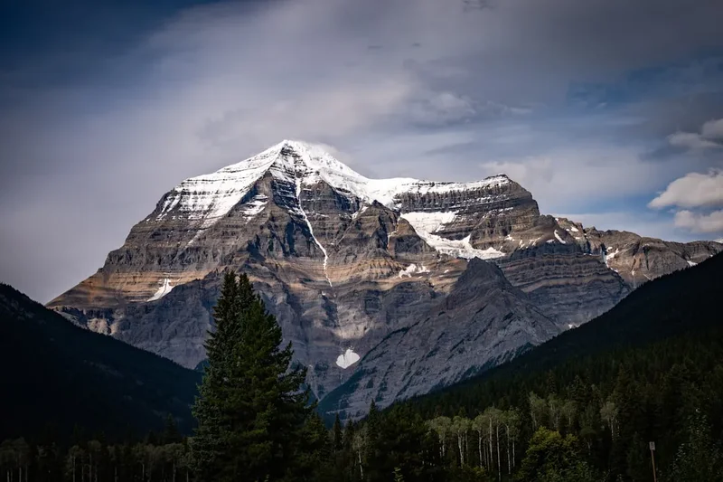
The Mount Asgard Approach is not merely a hike; it is a pilgrimage into the raw, primordial architecture of the Earth. Located within Auyuittuq National Park on Baffin Island, Nunavut, this 30-kilometre trek (one-way approach) traverses the Akshayuk Pass, a massive glacial trough that carves through the Penny Highlands. The destination is the base of Mount Asgard, a twin-peaked granite monolith that rises 2,015 metres above sea level, featuring two flat-topped cylindrical towers that are among the most recognisable and formidable rock faces on the planet. This is a landscape of superlatives: home to the world’s highest vertical drop at Mount Thor, ancient glaciers that have remained frozen for millennia, and a silence so profound it feels physical. Accessing this remote wilderness requires a flight to the Inuit community of Pangnirtung, followed by a boat journey through the dramatic Cumberland Sound to the trailhead at Overlord. For those who seek the ultimate test of self-reliance in a landscape that remains indifferent to human presence, the approach to Asgard offers a transformative experience in the "Land That Never Melts."
- Distance: 30.0 km (one-way approach to Asgard base)
- Duration: 3–5 days (approach only; 8–12 days for full pass traverse)
- Season: July to August (peak Arctic summer)
- Elevation Gain: 1,500 m (cumulative over undulating moraine and river terraces)
- Difficulty: Very Challenging (remote, no marked trail, river crossings, polar bear territory)
- Highest Point: Summit Lake (approx. 400 m) with surrounding peaks exceeding 2,000 m
- Closest Settlement: Pangnirtung, Nunavut, Canada
- Access: Boat or snowmobile transfer from Pangnirtung to Overlord trailhead
Overview
The Mount Asgard Approach is the definitive Arctic trekking experience, taking hikers through the southern half of the 97-kilometre Akshayuk Pass. The route follows the Weasel River valley, a corridor of staggering scale where the valley floor is often several kilometres wide, yet dwarfed by granite walls that rise 1,500 metres vertically on either side. This is a landscape shaped by the relentless power of ice; the Penny Ice Cap, a remnant of the last ice age, sits atop the surrounding plateaus, feeding the numerous glaciers that spill down into the valley like frozen rivers. The terrain is a complex mosaic of shifting glacial moraines, expansive sand flats, boulder fields the size of houses, and delicate Arctic tundra that erupts in a brief, vibrant display of wildflowers during the short summer window.
Walking here is a lesson in geological time. The rocks of the Akshayuk Pass are part of the Canadian Shield, some of the oldest crust on Earth, dating back nearly three billion years. As you progress north from the Overlord trailhead, the peaks become increasingly dramatic. You will pass beneath the shadow of Mount Thor, which boasts a 1,250-metre vertical face with an average overhang of 15 degrees—the greatest vertical drop on Earth. The culmination of the approach is the sight of Mount Asgard itself. Named after the realm of the gods in Norse mythology, its twin cylindrical towers appear almost artificial in their geometric perfection, standing as silent sentinels over the Arctic interior.
Unlike traditional trails, there is no maintained path. While a general route exists, hikers must constantly navigate based on river levels, shifting gravel bars, and the stability of moraine slopes. The environment is dynamic and unforgiving; weather can transition from 20°C sunshine to freezing rain and gale-force winds within an hour. There are no trees, no shelter, and no easy exit. This total immersion in a wilderness without infrastructure is what draws the experienced trekker. It is a place where the scale of the landscape forces a profound perspective on the human condition, offering a rare opportunity to witness a world still governed by the rhythms of the ice and the tides.
The journey is also a cultural one. Auyuittuq National Park is the traditional territory of the Inuit, who have travelled these valleys for generations to hunt and move between the fjords. Every stone and river has a story, and the modern trekker follows in the footsteps of a culture that has mastered survival in one of the most extreme environments on Earth. To walk the approach to Asgard is to respect both the power of the natural world and the resilience of the people who call it home.
History and Cultural Context
The Akshayuk Pass has served as a vital travel corridor for the Inuit of Baffin Island for thousands of years. Known as the "gateway" between Cumberland Sound in the south and Davis Strait in the north, the pass allowed seasonal movement for hunting caribou and accessing different marine resources. The name Auyuittuq translates from Inuktitut as "the land that never melts," a reference to the permanent ice caps and glaciers that define the region. For the Inuit, the landscape is not a "wilderness" in the Western sense, but a home and a provider, rich with ancestral knowledge and spiritual significance.
European interest in the region began with the search for the Northwest Passage, but the interior of Baffin Island remained largely unmapped by outsiders until the 20th century. The first recorded mountaineering expedition to the Akshayuk Pass occurred in 1953, led by P.D. Baird. This expedition saw the first ascent of Mount Asgard’s North Peak, a feat that put the region on the global climbing map. The South Peak was not conquered until 1971. These early explorers faced immense logistical challenges, relying on dog teams and heavy canvas gear to navigate the frozen valleys.
Mount Asgard achieved a unique level of pop-culture fame in 1976, when it was chosen as the filming location for the opening sequence of the James Bond film *The Spy Who Loved Me*. Stuntman Rick Sylvester performed a death-defying ski BASE jump off the summit of Asgard, deploying a Union Jack parachute as he plummeted toward the valley floor. While the film depicted the location as being in Austria, the unmistakable granite towers of Asgard became iconic to viewers worldwide, cementing the mountain's reputation as one of the world's most dramatic natural features.
Auyuittuq was established as a National Park Reserve in 1972 and officially became a National Park in 2000 following the creation of the territory of Nunavut. Today, the park is co-managed by Parks Canada and the Inuit of Pangnirtung and Qikiqtarjuaq. This partnership ensures that the ecological integrity of the park is protected while respecting Inuit Qaujimajatuqangit (traditional knowledge). Hikers are encouraged to learn about the local history and the ongoing relationship between the Inuit and the land, which remains a vibrant part of the Arctic's cultural fabric.
Want more background? Read extended notes on history and cultural context → Learn more
Seasonal Highlights and Weather Reality
The window for trekking the Mount Asgard Approach is exceptionally narrow, dictated by the melting of sea ice and the onset of the Arctic winter. The primary season runs from early July to late August. Outside of this window, the pass is either locked in ice (accessible only by snowmobile or dog sled) or experiencing the volatile transitions of spring and autumn.
July: The Month of Light and Water
July is the time of the midnight sun, where the sun never sets, providing 24 hours of daylight for navigation and photography. This is also the period of peak snowmelt. While the temperatures are relatively mild (5°C to 15°C), the rivers are at their highest and most dangerous. Glacial meltwater peaks in the late afternoon, making river crossings significantly more difficult than in the early morning. The tundra is at its most colourful, with Arctic heather, moss campion, and mountain avens in full bloom.
August: Stability and Cooling
By August, the river levels typically begin to drop as the initial snowmelt subsides, though heavy rain can still cause flash flooding. The mosquitoes and blackflies, which can be intense in July, begin to diminish. The sun starts to dip below the horizon for a few hours each night, bringing the return of twilight and, by late August, the possibility of seeing the Aurora Borealis (Northern Lights). Temperatures begin to cool, often hovering between 0°C and 10°C, and the first dustings of "termination dust" (new snow) may appear on the high peaks.
Weather Reality
Weather in the Akshayuk Pass is notoriously unpredictable. The "funnel effect" of the high granite walls can create intense wind tunnels, with gusts exceeding 100 km/h. Rain is common and can be persistent, often accompanied by thick fog that reduces visibility to a few metres. Hypothermia is a constant risk, even in summer, due to the combination of wet clothing and wind chill. Trekkers must be prepared for "four seasons in one day" and possess the mental fortitude to wait out storms in their tents for 24–48 hours if necessary.
Recommended Itinerary
3-Day Mount Asgard Approach Itinerary
Day 1: Overlord Trailhead to Ulu Peak Area
- Distance: 12 km
- Elevation gain: 300 m (undulating)
- Time: 6–8 hours
- Morning boat transfer from Pangnirtung to the Overlord trailhead at the head of Pangnirtung Fjord.
- Begin the trek by navigating the moraine and sand flats of the lower Weasel River.
- Pass the "Arctic Circle" marker, officially entering the polar region.
- The terrain is a mix of soft sand, which can be tiring, and stable river terraces.
- Cross several small meltwater streams (usually ankle-deep).
- Camp near the base of Ulu Peak, offering spectacular views of the jagged ridgeline.
- Key Waypoint: The Arctic Circle sign (66° 10 m N).
Day 2: Ulu Peak to Thor Base (Schwarzenbach Falls)
- Distance: 10 km
- Elevation gain: 400 m
- Time: 7–9 hours
- The valley narrows as you approach the most dramatic section of the pass.
- Navigate around the massive debris flow of the Windy Lake area.
- Cross the Weasel River if conditions allow, or stay on the eastern bank depending on water levels.
- Pass beneath the towering 1,250-metre vertical face of Mount Thor.
- Witness the spectacular Schwarzenbach Falls cascading down the western valley wall.
- Camp at the designated site near the base of Thor, listening to the roar of the river and the occasional rockfall from the cliffs above.
- Key Waypoint: Mount Thor viewpoint.
Day 3: Thor Base to Summit Lake and Asgard Base
- Distance: 8 km
- Elevation gain: 800 m (including final ascent to Asgard viewpoint)
- Time: 8–10 hours
- A challenging day involving significant boulder hopping and moraine navigation.
- Climb the steep moraine wall to reach Summit Lake, the highest point of the pass.
- The lake is often filled with ice floes even in mid-summer.
- From the northern end of Summit Lake, the twin towers of Mount Asgard come into full view.
- Establish a base camp on the stable benches overlooking the Caribou Glacier.
- Spend the evening watching the light change on the granite faces of Asgard and Mount Loki.
- Key Waypoint: Summit Lake moraine crest.
Important Notes:
- This itinerary is for the approach only. Most hikers spend 1–2 days at the base of Asgard for exploration before returning or continuing the full traverse to Qikiqtarjuaq.
- River crossing times are critical; always aim to cross major streams in the early morning when glacial melt is at its lowest.
- There are no bridges in the park; all crossings are fords.
- Hiking times are highly dependent on pack weight and terrain conditions (sand vs. boulders).
- Always have a "buffer day" in your schedule for weather delays.
Planning and Bookings
Book Your Trip
Everything you need to plan your journey
Accommodation
Find places to stay near Pangnirtung
Flights
Search flights to Pangnirtung
Essential Preparation
Planning a trip to Auyuittuq National Park is a significant undertaking that requires months of preparation. The first step is logistical: you must fly to Pangnirtung, Nunavut. Flights typically depart from Ottawa or Montreal with a connection in Iqaluit. These flights are expensive and can be delayed for days by Arctic weather, so booking flexible tickets and allowing buffer time in your itinerary is essential.
Once in Pangnirtung, you must coordinate with a local Inuit outfitter for a boat transfer to the trailhead at Overlord. These transfers are tide-dependent, as the fjord has one of the highest tidal ranges in the world. You should also spend at least one day in Pangnirtung to visit the Parks Canada office for your mandatory orientation and to soak in the local culture at the Uqqurmiut Centre for Arts & Crafts.
Fitness is paramount. You will be carrying a heavy pack (20–30 kg) over uneven, unstable terrain for multiple days. Training should focus on leg strength, core stability, and endurance, ideally by hiking with a weighted pack on varied terrain. Basic mountaineering knowledge and advanced navigation skills (map and compass) are required, as there are no trail markers or signs once you leave the trailhead.
Trail Accommodation
There are no huts, lodges, or permanent shelters on the Mount Asgard Approach. This is a pure wilderness camping experience. While there are some "designated" camping areas with emergency shelters, these shelters are for life-threatening emergencies only and are not to be used for regular accommodation.
Camping Details:
- You must bring a high-quality, 4-season tent capable of withstanding high winds and heavy rain.
- Campsites should be chosen on durable surfaces (gravel or sand) to protect the fragile tundra.
- Emergency shelters (e.g., at Thor and Summit Lake) contain a radio for contacting Parks Canada but no beds or cooking facilities.
- There are no toilets; hikers must follow strict waste management protocols (see Leave No Trace section).
- Water is sourced from side streams (glacial meltwater should be filtered to remove "rock flour" or silt).
Required Gear
- 4-Season Tent: Must be sturdy with a full fly and multiple guy-line points.
- Backpack: 75–85L capacity with a robust suspension system for heavy loads.
- Sleeping Bag: Rated to at least -10°C (even in summer, temperatures can drop below freezing).
- Sleeping Pad: High R-value (insulated) to protect against the cold ground.
- Boots: Sturdy, waterproof leather or synthetic boots with excellent ankle support for boulder hopping.
- River Crossing Shoes: Lightweight sneakers or dedicated wading boots with a secure strap (crocs are not recommended due to lack of grip in fast water).
- Navigation: Topographic maps (1:50,000 scale), compass, and a GPS unit with spare batteries.
- Satellite Communication: Garmin inReach or Zoleo is mandatory for safety in this remote area.
- Bear Barrel/Canister: Required for food storage to prevent attracting polar bears or ravens.
What to Bring
- Food: High-calorie, lightweight dehydrated meals for the duration of the trip plus 3 days of emergency rations.
- Stove and Fuel: Multi-fuel or white gas stoves are preferred as canister gas can be difficult to find in Pangnirtung and performs poorly in the cold.
- Water Treatment: A high-flow filter (like a Katadyn Gravity filter) is best for handling silty glacial water.
- Clothing Layers: Merino wool base layers, fleece mid-layer, down or synthetic puffy jacket, and a high-quality Gore-Tex shell (jacket and trousers).
- Personal Care: Biodegradable soap, sunblock (the Arctic sun is intense), and a head net for insects.
- Repair Kit: Duct tape, needle/thread, sleeping pad patches, and stove maintenance tools.
- First Aid: Comprehensive kit including blister care, NSAIDs, and any personal medications.
Permits
All visitors to Auyuittuq National Park must register with Parks Canada and obtain a permit. This process is strictly enforced to ensure the safety of hikers and the protection of the environment. Unlike some popular parks, there is currently no "lottery" system, but you must book your orientation session in advance.
Permit Process:
- Registration: Contact the Parks Canada office in Pangnirtung (or Qikiqtarjuaq if doing the full traverse) at least several weeks before your arrival.
- Mandatory Orientation: Upon arrival in Pangnirtung, all hikers must attend a 1–2 hour safety orientation. This covers polar bear safety, river crossing techniques, and park regulations. You cannot enter the park without this.
- Fees: Daily northern park entry fees apply (approx. $25–$30 CAD per person, per day). An annual pass is available if staying longer than 5 days.
- De-registration: You must check back in with Parks Canada upon your return. Failure to do so will trigger an expensive and unnecessary Search and Rescue operation.
Logistical Costs:
- Boat Transfers: Expect to pay $200–$400 CAD per person for the round-trip boat transfer from Pangnirtung to Overlord, depending on group size.
- Flights: Flights from southern Canada (Ottawa/Montreal) to Pangnirtung typically range from $2,000 to $4,000 CAD return.
Other Activities in the Area
While the trek to Asgard is the main draw, the region offers other unique Arctic experiences:
- Uqqurmiut Centre for Arts & Crafts: Located in Pangnirtung, this world-renowned centre is famous for its intricate tapestries and "Pang hats." It is a must-visit to support local Inuit artists.
- Fishing: Arctic Char are abundant in the fjords and rivers. A territorial fishing licence is required, and local guides can take you to the best spots.
- Wildlife Viewing: While polar bears are the primary concern, you may also see Arctic foxes, lemmings, and various bird species like the Gyrfalcon or Snowy Owl. In the fjords, look for seals and occasionally Beluga or Bowhead whales.
- Mount Thor Climbing: For elite big-wall climbers, the west face of Mount Thor represents one of the ultimate challenges in the mountaineering world.
- Pangnirtung Fiord Boat Tours: If you have extra time, local outfitters can take you deeper into the fjord system to see abandoned whaling stations and dramatic sea cliffs.
Safety and Conditions
Polar Bear Safety: Auyuittuq is polar bear territory. While they are more common on the coast, they do travel through the Akshayuk Pass. You must attend the Parks Canada orientation, carry bear deterrents (bear spray and/or bangers), and maintain a "clean camp" by storing all food and scented items in bear-resistant containers. Never cook inside or near your tent.
River Crossings: This is the most significant objective hazard on the Asgard approach. The Weasel River and its tributaries are glacial, cold, and fast-moving.
- Cross in the morning when water levels are lowest.
- Never cross alone; use the "triangle" or "line" method for stability.
- Unbuckle your backpack waist belt and chest strap before crossing so you can jettison the pack if you fall.
- Wear footwear; the rocks are sharp and slippery.
- If the water is above mid-thigh, do not cross. Wait for levels to drop or find a wider, shallower section.
Hypothermia and Exposure: The combination of cold water, wind, and rain can lead to hypothermia even in temperatures well above freezing. Always have a dry set of "camp clothes" sealed in a waterproof dry bag. Recognise the "umbles" (stumbling, mumbling, fumbling) as early signs of hypothermia in yourself and your partners.
Emergency Communication: There is no mobile phone coverage in the park. A satellite communication device (InReach, SPOT, or Satellite Phone) is essential. In the event of an emergency, help may be days away due to weather conditions preventing helicopter flight.
Glacial Hazards: If you choose to leave the valley floor to approach the glaciers or the base of Asgard, be aware of crevasse risks and rockfall. The moraines are often unstable; "active" moraines can slide without warning.
Side Trips and Points of Interest
Mount Thor (The World's Highest Vertical Drop): Even if you are not a climber, spending a few hours at the base of Thor is a humbling experience. Looking up at the 1,250-metre overhanging face provides a sense of scale that is difficult to find anywhere else on Earth. The "Schwarzenbach Falls" nearby provide a beautiful foreground for photography.
Summit Lake: The literal high point of the pass. The lake is a stark, beautiful place where the ice often lingers throughout the summer. The moraine walls surrounding the lake offer excellent vantage points for looking both south toward Thor and north toward Asgard.
The Caribou Glacier: Located near the base of Mount Asgard, this glacier provides a close-up look at the "Land That Never Melts." You can walk to the toe of the glacier (with caution) to see the blue ice and the massive lateral moraines it has pushed aside.
The Arctic Circle Marker: A simple but significant landmark. Crossing the Arctic Circle (66° 10 m N) is a milestone for many travellers. The marker is located about 12 km from the Overlord trailhead and makes for a great photo opportunity.
Leave No Trace

The Arctic ecosystem is incredibly fragile. A footprint on the moss can remain visible for decades, and waste takes much longer to decompose in the cold, dry climate. As a visitor, you have a moral and legal obligation to minimise your impact.
Arctic LNT Principles:
- Pack it in, Pack it out: This includes all trash, food scraps, and even "biodegradable" items like orange peels or tea bags.
- Human Waste: Parks Canada requires the use of "WAG bags" (Waste Aggregation and Gelling) in certain high-use areas, or the "smear" method in remote areas (though WAG bags are preferred and often mandatory). Never bury toilet paper; pack it out in a sealed bag.
- Durable Surfaces: Walk on rocks, gravel, or sand whenever possible. Avoid stepping on the delicate tundra vegetation.
- No Fires: There is no wood in the Arctic. Use only portable stoves for cooking.
- Respect Wildlife: Observe from a distance. If an animal changes its behaviour because of your presence, you are too close. This is especially true for nesting birds and polar bears.
- Leave What You Find: Do not collect rocks, fossils, or plants. Leave archaeological sites (like Inuit tent rings) exactly as you found them.