Mt. Arthur Summit - A Challenging Day Hike in Kahurangi National Park
The Mt. Arthur Summit track offers a demanding yet incredibly rewarding day hike within the vast and rugged beauty of Kahurangi National Park, New Zealand. This challenging route ascends through diverse forest types, transitioning from lush temperate rainforest to subalpine scrub, culminating in a spectacular alpine summit with panoramic views across the northern South Island. It's a journey that tests physical endurance and rewards with breathtaking vistas, making it a must-do for experienced hikers seeking a significant day adventure.
- Distance: 17.4 km return
- Duration: 6–8 hours
- Elevation Gain: 1,130 m
- Difficulty: Challenging
- Best Time: December to March (summer/early autumn)
- Closest City: Nelson
- Trailhead Access: Via Brook St, Nelson (SH6), then unsealed road. Parking available.
- Permits: Not required for day hiking.
Overview
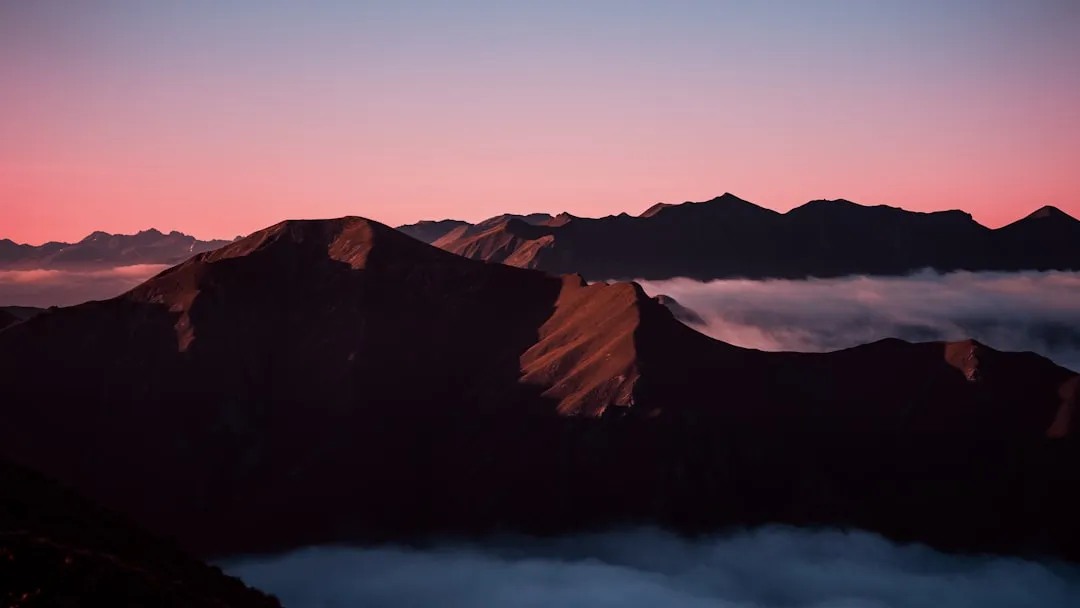
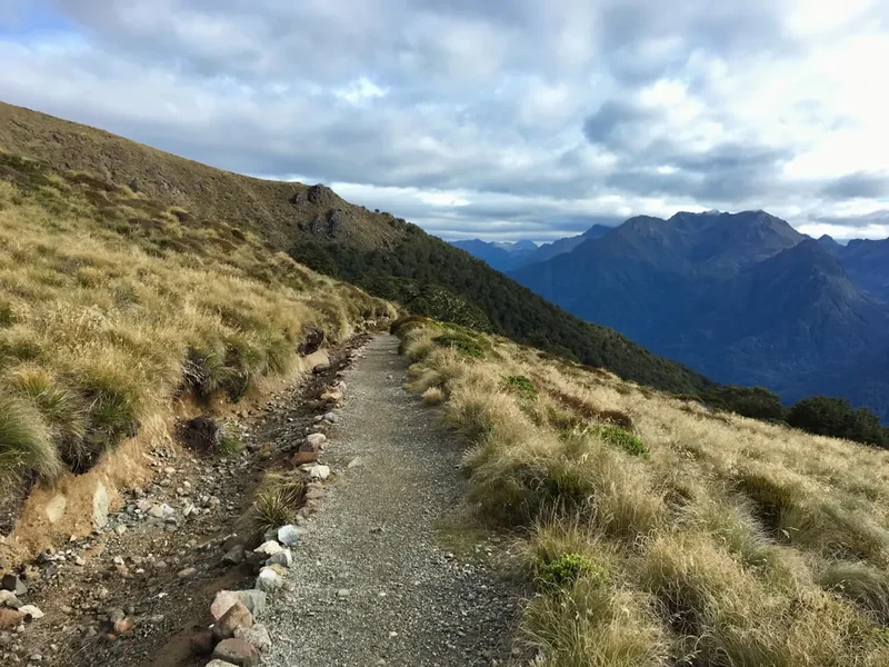
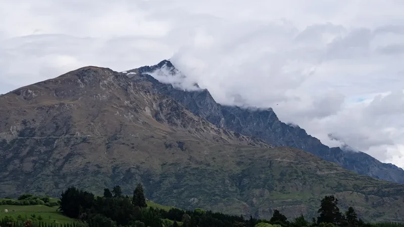
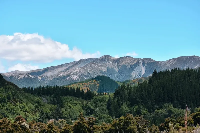
The ascent to Mt. Arthur Summit is a true test of a hiker's stamina and determination. Starting from the Brook Valley, the trail immediately begins its relentless climb, taking you through a changing tapestry of New Zealand's native flora. Initially, you'll be enveloped by the dense, moss-laden canopy of temperate rainforest, where ancient trees create a cathedral-like atmosphere. As you gain altitude, the forest gradually thins, giving way to more open subalpine terrain. The final push to the summit is a steep, rocky scramble, demanding careful foot placement and a good level of fitness. However, the effort is amply repaid. From the summit, on a clear day, the views are simply phenomenal. You'll be treated to sweeping vistas encompassing the Tasman Bay, the Abel Tasman National Park, the rugged peaks of Kahurangi National Park, and on exceptionally clear days, even the distant Southern Alps. This is a hike where the journey is as significant as the destination, offering a profound connection with the wild heart of the northern South Island.
The trail is well-marked but steep and exposed in sections, particularly as you approach the summit. The elevation gain of 1,130 metres over 17.4 kilometres means a sustained and significant climb. The weather in alpine environments can change rapidly, so preparedness is key. While the summit is accessible year-round for experienced mountaineers with appropriate gear, the recommended season for day hikers is during the warmer months when snow and ice are less likely to be a factor on the upper reaches of the track.
This hike is not for the faint-hearted. It requires a good level of cardiovascular fitness, strong legs, and a head for heights. However, for those who meet these requirements, the Mt. Arthur Summit offers an unforgettable wilderness experience, a chance to immerse yourself in the grandeur of Kahurangi National Park and to stand atop a peak that commands an awe-inspiring panorama.
History and Cultural Context
The area surrounding Mt. Arthur has a rich history, deeply intertwined with the traditional territories of the Māori iwi, particularly Ngāti Rarua and Te Āti Awa. These tribes have a long-standing connection to the land, utilising its resources for sustenance and as travel routes for generations. The valleys and mountains provided food, materials, and pathways, and the cultural significance of this landscape is profound.
European exploration and settlement in the region began in earnest in the mid-19th century, driven by the search for resources and land. The rugged terrain of Kahurangi National Park, however, meant that much of it remained largely untouched by extensive development. Early surveyors and prospectors would have traversed some of these routes, but the challenging nature of the landscape meant that large-scale infrastructure was never established within the park's core.
The establishment of Kahurangi National Park in 1971, and its subsequent expansion, recognised the immense ecological and scenic value of this vast wilderness. The park protects a significant portion of New Zealand's indigenous forests, alpine environments, and unique geological features. The Mt. Arthur Summit track, while a popular day hike, is part of a much larger network of trails that allow access to this protected area, preserving its natural character and cultural heritage.
The name "Mt. Arthur" itself is believed to have been given by early surveyors, likely in honour of a prominent figure of the time, though specific details are often scarce for such naming conventions. Regardless of the exact origin, the mountain stands as a significant landmark within the region, a prominent peak that has drawn adventurers for decades.
Seasonal Highlights and Weather Reality
The Mt. Arthur Summit track is best enjoyed during the warmer months, typically from December to March. This period offers the highest likelihood of favourable weather conditions, with longer daylight hours and less risk of snow and ice on the upper sections of the trail.
Summer (December to February): This is the prime season for tackling the summit. Days are long, and the subalpine vegetation may be in bloom. However, summer can also bring intense sunshine, and the exposed sections of the track offer little shade. Sandflies can be present, especially in damper areas and during calmer periods, so insect repellent is advisable. Afternoon thunderstorms are also a possibility in mountainous regions, so starting early is always recommended.
Autumn (March to May): March can still offer excellent hiking conditions, with cooler temperatures and fewer sandflies. The autumn colours in the beech forests can be spectacular. However, as you move into April and May, the risk of frost and snow increases significantly, especially at higher elevations. The track can become icy and treacherous, and visibility can be severely reduced by fog and cloud.
Winter (June to August): This season is generally not recommended for the Mt. Arthur Summit track for day hikers unless they possess advanced winter mountaineering skills, appropriate equipment (ice axe, crampons), and extensive experience in alpine navigation. Snowfall can be heavy and persistent, making the track impassable and dangerous. Avalanche risk is also a serious consideration.
Spring (September to November): Spring can be a mixed bag. While snow begins to melt, especially at lower elevations, higher sections of the track may remain snow-covered well into November. Unpredictable weather, including late snowfalls and strong winds, is common. It's essential to check track conditions thoroughly before attempting a spring hike.
Weather Reality: Regardless of the season, the weather in the mountains can change with alarming speed. Always be prepared for a wide range of conditions, including strong winds, heavy rain, and a significant drop in temperature, even on a seemingly clear day. The summit itself is exposed, and wind chill can make it feel considerably colder than the forecast temperature.
Recommended Itinerary
Mt. Arthur Summit Day Hike Itinerary
Early Morning (Approx. 7:00 AM): Departure from Nelson
- Drive north from Nelson on State Highway 6.
- Turn onto Brook Street, which becomes the Brook Valley Road.
- The road transitions to an unsealed surface closer to the trailhead. Allow approximately 30 minutes driving time from Nelson.
- Arrive at the Mt. Arthur Summit trailhead parking area.
- Final gear check, ensure you have water, food, and appropriate clothing layers.
Morning (Approx. 7:30 AM - 11:30 AM): Ascent through Forest
- Begin the hike from the trailhead.
- The initial section is a steady, sometimes steep, climb through dense temperate rainforest.
- Pass through areas of moss-covered trees, ferns, and native bush.
- The trail is well-defined but can be muddy and root-covered, especially after rain.
- Gain significant elevation as you ascend through the forest canopy.
- Key Waypoints: Look for signage indicating progress towards the summit.
Midday (Approx. 11:30 AM - 1:00 PM): Transition to Subalpine Terrain and Summit Push
- The forest begins to thin, and the terrain opens up into subalpine scrub and tussock.
- The gradient remains steep, and the track may become more exposed to the elements.
- Continue the ascent towards the summit ridge.
- Be aware of changing weather conditions as you gain altitude.
- Key Waypoints: The landscape will visibly change from dense forest to more open alpine environments.
Early Afternoon (Approx. 1:00 PM - 2:00 PM): Summit and Lunch Break
- Reach the summit of Mt. Arthur (1,718 m).
- Spend time enjoying the 360-degree panoramic views.
- Take a well-deserved lunch break, but be mindful of the exposed conditions and potential for rapid weather changes.
- Capture photographs of the stunning scenery.
Afternoon (Approx. 2:00 PM - 5:00 PM): Descent and Return to Trailhead
- Begin the descent back down the same track.
- Take care on the steep sections, as descents can be hard on the knees.
- The return journey will offer different perspectives of the landscape.
- Continue through subalpine and then forest terrain.
- Arrive back at the trailhead parking area.
Late Afternoon (Approx. 5:00 PM onwards): Return to Nelson
- Drive back to Nelson.
- Consider stopping for refreshments in Nelson to celebrate your accomplishment.
Important Notes:
- This is a challenging day hike requiring good fitness.
- Start early to allow ample time and avoid afternoon weather.
- Carry sufficient water (at least 2-3 litres per person) as there are no reliable water sources on the upper track.
- Pack high-energy snacks and a substantial lunch.
- Always check the weather forecast before you go and be prepared for rapid changes.
- Wear sturdy, broken-in hiking boots.
- Carry layers of clothing, including waterproof and windproof outer shells.
- A personal locator beacon (PLB) is recommended for remote hikes.
Planning and Bookings
Book Your Trip
Everything you need to plan your journey
Accommodation
Find places to stay near Nelson
Flights
Search flights to Nelson
Essential Preparation
The Mt. Arthur Summit hike is a significant undertaking that requires careful planning. Given its challenging nature and remote location within Kahurangi National Park, thorough preparation is paramount. Before embarking on this hike, ensure you have a solid understanding of the route, the expected weather conditions, and your own physical capabilities. Base yourself in Nelson, the closest major city, which offers a full range of services for hikers. Nelson provides accommodation options from budget hostels to comfortable hotels, outdoor gear shops for last-minute purchases or rentals, supermarkets for stocking up on food and supplies, and a good selection of cafes and restaurants for pre- or post-hike meals. Allow at least half a day in Nelson for final preparations, including checking weather forecasts and purchasing any necessary items.
Trail Accommodation
This is a day hike requiring no overnight accommodation. The Mt. Arthur Summit track is designed to be completed within a single day, with hikers returning to the trailhead by evening. There are no huts, lodges, or campsites directly on the summit route itself. Hikers typically base themselves in Nelson or nearby accommodation and drive to the trailhead for the day's excursion.
Required Gear
- Sturdy Hiking Boots: Waterproof, with good ankle support and excellent grip. Ensure they are well broken-in to prevent blisters.
- Backpack: A comfortable day pack (25-35 litres) to carry essentials.
- Waterproof Jacket: Essential for protection against rain and wind. Gore-Tex or similar breathable, waterproof material is recommended.
- Waterproof Overtrousers: To keep your lower body dry in wet conditions.
- Warm Layers: Including a fleece or wool mid-layer and a thermal base layer. Avoid cotton.
- Hat and Gloves: Even in summer, the summit can be cold and windy.
- Navigation Tools: A map of the area, a compass, and a GPS device or smartphone with offline maps downloaded. Mobile phone reception is unreliable.
- First-Aid Kit: Comprehensive kit including blister treatment, pain relievers, bandages, antiseptic wipes, and any personal medications.
- Head Torch: With spare batteries, in case of unexpected delays or an early start/late finish.
- Sun Protection: High SPF sunscreen, sunglasses, and a wide-brimmed hat. The sun can be intense at higher altitudes.
What to Bring
- Food: High-energy snacks (nuts, dried fruit, energy bars) and a substantial lunch. Pack more than you think you'll need in case of delays.
- Water: At least 2-3 litres of water per person. There are no reliable water sources on the upper part of the track. Water treatment (filter or purification tablets) is recommended if you plan to refill from lower stream sources, but it's safer to carry all your water.
- Toiletries: Small personal items, including hand sanitiser and toilet paper. Pack out all waste.
- Insect Repellent: Sandflies can be prevalent, especially in damper areas and during calmer weather.
- Trekking Poles: Highly recommended for both the ascent and descent, as they can significantly reduce strain on your knees and ankles.
- Emergency Shelter: A lightweight emergency blanket or bivvy bag can be a lifesaver in unexpected situations.
- Camera: To capture the spectacular views.
- Whistle: For signalling in emergencies.
Permits
No specific permits are required for day hiking on the Mt. Arthur Summit track. As it is part of Kahurangi National Park, standard national park regulations apply, which generally prohibit fires outside designated areas and require visitors to respect the natural environment. However, for a simple day hike, no advance booking or permit purchase is necessary.
The trailhead is accessible via Brook Valley Road, which is a public road. Parking is available at the designated trailhead area. It is advisable to arrive early, especially on weekends or during peak season, as parking can become limited.
While no permits are needed, it is always a good practice to inform someone of your hiking plans, including your intended route, estimated return time, and who to contact if you do not check in. This is a standard safety precaution for any remote hike.
Other Activities in the Area
Nelson and the surrounding Tasman region offer a wealth of activities for outdoor enthusiasts and those seeking relaxation:
- Abel Tasman National Park: Famous for its golden beaches, turquoise waters, and coastal walking track. Accessible by water taxi or scenic flight from Nelson. Offers kayaking, swimming, and multi-day hiking opportunities.
- Kahurangi National Park (other tracks): Explore other trails within Kahurangi, such as the challenging Mount Owen or the more accessible tracks in the Cobb Valley.
- Nelson Lakes National Park: A scenic drive inland from Nelson, offering stunning lakes (Rotoiti, Rotoroa) and alpine scenery, with opportunities for hiking, fishing, and boating.
- Nelson City: Explore the vibrant arts and crafts scene, visit local galleries and studios, enjoy the city's cafes and restaurants, or relax on Tahunanui Beach.
- Wine and Craft Beer Tours: The Nelson region is renowned for its wineries and craft breweries. Numerous tours are available, offering tastings and scenic drives through the countryside.
- Kayaking and Water Sports: The sheltered waters of Tasman Bay and the nearby coast are ideal for kayaking, paddleboarding, and sailing.
- Mountain Biking: Nelson is a world-class mountain biking destination with extensive trail networks in the Maitai Valley and further afield.
Safety and Conditions
Pre-Hike Checks:
- Weather Forecast: Always check the MetService mountain forecast for the Kahurangi region and specifically for Mt. Arthur before you depart. Be prepared for rapid changes.
- Track Conditions: While this is a day hike, it's wise to check for any Department of Conservation (DOC) alerts or advisories for Kahurangi National Park.
- Road Conditions: Ensure Brook Valley Road is accessible. While generally well-maintained, unsealed roads can be affected by weather.
On the Trail:
- Fitness: This is a challenging hike with significant elevation gain. Ensure you are physically prepared.
- Navigation: The track is generally well-marked, but in poor visibility (fog, cloud), it can be easy to lose your way, especially on the upper, more exposed sections. Carry a map, compass, and GPS device, and know how to use them.
- Weather: The summit is exposed and can be significantly colder and windier than the trailhead. Be prepared for sudden changes in weather, including rain, strong winds, and even snow at higher elevations, regardless of the season. Hypothermia is a risk.
- Water: Carry sufficient water. There are no reliable water sources on the upper track.
- Sandflies: These can be a nuisance, particularly in warmer, damper conditions. Use effective insect repellent.
- Footwear: Wear sturdy, waterproof hiking boots with good ankle support.
- Communication: Mobile phone reception is unreliable in the park. Consider carrying a Personal Locator Beacon (PLB) for emergencies. Inform someone of your hiking plans and expected return time.
- Emergency: In case of emergency, call 111. If you have a PLB, activate it.
Respect the Environment: Stay on the marked track to protect fragile alpine vegetation. Pack out all rubbish. Do not light fires outside designated areas.
Side Trips and Points of Interest
While the primary objective is the summit, the journey itself offers several points of interest:
Forest Transition Zone: As you ascend, observe the distinct change in vegetation from dense temperate rainforest to more open subalpine scrub. This transition zone is rich in unique flora adapted to harsher conditions.
Rocky Outcrops and Ridges: The upper sections of the track often involve navigating over rocky terrain and along exposed ridges. These provide excellent vantage points for observing the geological formations of the area.
Panoramic Summit Views: The ultimate point of interest is the summit itself. On a clear day, the 360-degree views are unparalleled. Key landmarks visible include:
- Tasman Bay and the Northern Coastline: Offering expansive views towards the sea.
- Abel Tasman National Park: The distinctive golden beaches and clear waters of the park are often visible.
- Kahurangi National Park Interior: A vast expanse of rugged mountains, valleys, and remote wilderness stretching inland.
- Nelson City: The urban sprawl of Nelson can be seen in the distance, providing a sense of scale.
- Distant Peaks: On exceptionally clear days, the snow-capped peaks of the Southern Alps may be visible on the horizon.
Flora and Fauna: Keep an eye out for native birdlife, such as the endemic kea (though less common at this specific altitude than in higher alpine areas), tūī, bellbirds, and fantails in the forest sections. The subalpine areas may host unique alpine plants.
Leave No Trace
The Mt. Arthur Summit track traverses a sensitive alpine environment within Kahurangi National Park. Adhering to Leave No Trace principles is crucial to preserving this beautiful area for future generations.
- Plan Ahead and Prepare: Understand the trail, weather, and your own abilities. Pack appropriately and inform someone of your plans.
- Travel and Camp on Durable Surfaces: Stick to the marked trail. Avoid walking on fragile alpine vegetation, which can take years to recover. The summit area is rocky and exposed, so tread carefully.
- Dispose of Waste Properly: Pack out everything you pack in, including all food scraps, wrappers, and toilet paper. Use designated toilet facilities where available, or dig catholes at least 70 metres away from water sources, trails, and campsites if necessary (though not applicable for this day hike).
- Leave What You Find: Do not remove rocks, plants, or any natural objects. Take only photographs and memories.
- Minimize Campfire Impacts: Campfires are generally not permitted in national parks, and are certainly not feasible or advisable on this day hike.
- Respect Wildlife: Observe wildlife from a distance. Do not feed animals, as it can harm their health and alter their natural behaviours.
- Be Considerate of Other Visitors: Keep noise levels down, yield to uphill hikers, and be courteous to fellow trampers.
By following these principles, you help ensure that the Mt. Arthur Summit remains a pristine and enjoyable experience for everyone.