
Poiana Brasov Trail - A Carpathian Day Walk
The Poiana Brasov Trail offers a refreshing and accessible day walk experience in the heart of Romania's Carpathian Mountains. Located just a short distance from the historic city of Brasov, this trail provides a delightful escape into nature, showcasing the region's picturesque alpine meadows, dense coniferous forests, and panoramic mountain vistas. It's an ideal choice for those seeking a moderate challenge with rewarding scenery, suitable for families and hikers of varying fitness levels. The trail's accessibility and well-maintained path make it a popular destination for both locals and tourists looking to experience the natural beauty of the Postăvaru Massif.
- Distance: 12.5 km one-way
- Duration: 4–5 hours
- Elevation Gain: 600 m
- Difficulty: Moderate
- Season: May to October
- Closest City: Brasov
- Trailhead Access: Poiana Brasov resort, accessible by bus or car from Brasov
- Permits: Not required
Overview
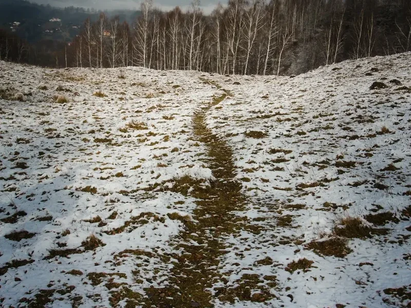
The Poiana Brasov Trail is a circular or point-to-point route (depending on the chosen variation) that winds its way through the diverse landscapes surrounding the popular Poiana Brasov ski resort. The journey typically begins from the resort centre, ascending through fragrant pine forests that gradually open up to reveal expansive alpine meadows dotted with wildflowers during the warmer months. The moderate elevation gain of 600 metres is spread across the 12.5 km distance, making for a steady but manageable climb.
As you ascend, the air becomes crisper, and the sounds of the forest replace the bustle of the resort. Key waypoints often include scenic clearings offering glimpses of the surrounding peaks of the Postăvaru Massif, such as the iconic Postăvaru Peak itself. The trail is well-marked, though variations exist, allowing hikers to tailor the experience to their preferences. Some routes might lead to specific viewpoints or natural landmarks, while others focus on a more direct ascent and descent.
The summit or highest point of the trail offers breathtaking panoramic views of the surrounding mountain ranges, including the Bucegi Mountains in the distance. On a clear day, the vista extends over the rolling hills and valleys of Transylvania. The descent often follows a different path, providing a new perspective on the landscape and ensuring a varied hiking experience. The trail's popularity means it can be busy, especially on weekends and during peak season, but the sheer scale of the mountains ensures that moments of tranquility can still be found.
History and Cultural Context
The area around Poiana Brasov has a long history of human interaction, primarily linked to pastoralism and forestry. For centuries, these mountains have provided grazing land for sheep and cattle, and timber for local communities. The development of Poiana Brasov as a modern tourist resort began in the mid-20th century, transforming it into a hub for winter sports and summer mountain activities.
The trails themselves, while not ancient pilgrimage routes in the same vein as some other European mountain paths, have evolved from old shepherd tracks and logging routes. Their current form as marked hiking trails is a result of efforts to promote tourism and outdoor recreation in the region. The proximity to Brasov, a city with a rich medieval history dating back to the 13th century, means that the natural beauty of the surrounding mountains has always been a backdrop to human settlement and development.
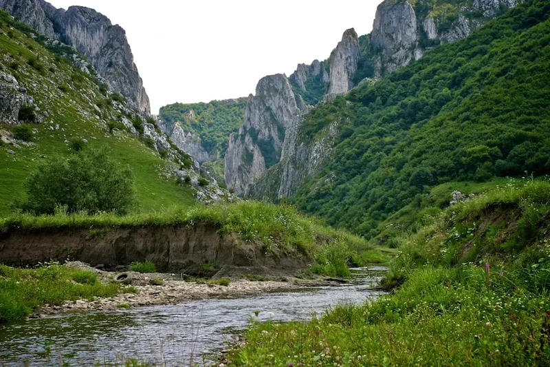
The Postăvaru Massif, where the Poiana Brasov Trail is located, is part of the Southern Carpathians, a mountain range known for its diverse flora and fauna, including significant populations of brown bears, wolves, and lynx. While encounters are rare on well-trodden paths, the presence of these large predators is a reminder of the wildness of the Carpathian ecosystem. The trails offer a way to connect with this natural heritage, providing a recreational outlet that complements the historical and cultural attractions of nearby Brasov.
Seasonal Highlights and Weather Reality
The Poiana Brasov Trail is best enjoyed during the warmer months, from late spring through to early autumn. Each season offers a distinct experience:
Spring (May - June): The meadows burst into vibrant colour with a profusion of wildflowers. The forests are lush and green, and the air is fresh. Snowmelt can still be present at higher elevations early in the season, and some higher paths might be muddy. Temperatures are generally mild, making for pleasant hiking conditions.
Summer (July - August): This is the peak season for hiking. The weather is typically warm and sunny, ideal for enjoying the panoramic views. The meadows are at their most spectacular, attracting butterflies and other insects. However, summer can also bring occasional thunderstorms, particularly in the afternoons. It's essential to be prepared for sudden changes in weather and to start your hike early in the day.
Autumn (September - October): Autumn offers a spectacular display of colours as the deciduous trees in the lower sections of the forest turn shades of gold, red, and orange. The air is crisp and clear, offering excellent visibility. This is often considered one of the best times to hike, with fewer crowds and cooler temperatures. However, by late October, the first snowfalls can occur at higher elevations, making the trail more challenging.
Winter (November - April): While Poiana Brasov is a renowned ski resort, the hiking trails are generally covered in snow and ice. They are not typically recommended for hiking without specialised winter gear (snowshoes, crampons) and experience. The focus shifts to skiing and other winter sports.
Weather Considerations: Mountain weather can be unpredictable. Even in summer, temperatures can drop significantly at higher elevations, and rain or fog can descend rapidly. Always check the weather forecast before you set out and be prepared for a range of conditions, including wind, rain, and cooler temperatures, even on a sunny day.
Recommended Itinerary
Poiana Brasov Trail - Day Walk Itinerary
This itinerary assumes a moderate pace and includes time for breaks and enjoying the scenery. It can be adapted based on individual fitness and preferences.
Early Morning (Approx. 8:00 AM - 9:00 AM): Arrival in Poiana Brasov
- Travel from Brasov city centre to Poiana Brasov resort.
- Allow approximately 30 minutes for the bus or car journey.
- Familiarise yourself with the resort area and locate the trailhead.
- Final gear check and preparation.
Morning (Approx. 9:00 AM - 12:00 PM): Ascent through Forest and Meadows
- Begin the hike from the main resort area.
- The initial section often leads through dense coniferous forests, with well-marked paths.
- The trail gradually begins to ascend, with an elevation gain of approximately 300-400 metres during this phase.
- Look for trail markers (often painted stripes on trees or rocks, or specific signs).
- As you gain altitude, the forest may thin out, giving way to open meadows.
- Enjoy the changing vegetation and the increasing sense of remoteness.
- Take short breaks to hydrate and appreciate the emerging views.
Midday (Approx. 12:00 PM - 1:30 PM): Reaching Higher Elevations and Lunch Break
- Continue the ascent towards the higher parts of the trail.
- You will likely reach a point offering more expansive views of the surrounding Postăvaru Massif.
- Find a suitable spot for a picnic lunch, perhaps at a scenic clearing or a designated rest area.
- This is a good opportunity to rest your legs and refuel.
- Observe the flora and fauna; keep an eye out for mountain birds.
Afternoon (Approx. 1:30 PM - 3:30 PM): Summit Views and Descent Preparation
- The final push towards the highest accessible point of the trail.
- Depending on the specific route, this might be Postăvaru Peak or a prominent viewpoint nearby.
- Spend time at the summit or viewpoint, taking in the 360-degree panoramas.
- Identify landmarks in the distance, such as the Bucegi Mountains.
- Begin the descent, which may follow the same path or a different route for variety.
- The descent is generally less strenuous but requires careful footing, especially on steeper sections.
Late Afternoon (Approx. 3:30 PM - 5:00 PM): Return to Poiana Brasov
- Continue your descent back towards the Poiana Brasov resort.
- The forest will become denser again as you lose altitude.
- Arrive back in Poiana Brasov, completing the approximately 12.5 km hike.
- Allow time for a well-deserved rest and perhaps a refreshment at one of the resort's establishments.
Important Notes:
- This is a day hike; no overnight accommodation is required.
- Trail markings can vary; always pay attention to signs and the terrain.
- Carry sufficient water and snacks, as facilities on the trail are limited.
- Wear appropriate footwear and clothing for mountain hiking.
- Check the weather forecast before you depart.
Planning and Bookings
Book Your Trip
Everything you need to plan your journey
Accommodation
Find places to stay near Brasov
Flights
Search flights to Brasov
Essential Preparation
The Poiana Brasov Trail is a day hike, simplifying logistical planning compared to multi-day treks. The primary consideration is reaching the trailhead in Poiana Brasov from the city of Brasov. This can be achieved via public transport (bus line 20 is a frequent and reliable option) or by private vehicle. Driving offers more flexibility, with a journey time of around 30 minutes on a paved, well-maintained road. Parking is available in Poiana Brasov, but it can become congested during peak tourist seasons and weekends, so arriving early is advisable.
Brasov itself is a major city with excellent transport links, including a train station connecting to Bucharest and other Romanian cities. Accommodation options in Brasov range from budget hostels to luxury hotels, providing a comfortable base before or after your hike. Poiana Brasov also offers accommodation, but it is generally more expensive and geared towards ski tourism.
Before setting out, ensure you have checked the weather forecast for the mountain region, as conditions can differ significantly from the city. Familiarise yourself with the trail markings and consider downloading an offline map of the area, although the main trails are generally well-signposted.
Trail Accommodation
This is a day hike requiring no overnight accommodation.
Required Gear
- Hiking Boots: Sturdy, broken-in hiking boots with good ankle support are essential for navigating uneven terrain and providing stability on ascents and descents.
- Waterproof Jacket: A lightweight, waterproof and windproof jacket is crucial, as mountain weather can change rapidly, bringing rain or strong winds.
- Layers of Clothing: Advise dressing in layers. A moisture-wicking base layer, an insulating mid-layer (fleece or down jacket), and an outer shell provide adaptability to changing temperatures.
- Navigation Tools: While the trail is generally well-marked, a map of the area and a compass or GPS device (or a reliable offline map app on a smartphone) are recommended for safety.
- Sun Protection: A wide-brimmed hat, sunglasses, and high-SPF sunscreen are important, especially during summer months, as sun exposure can be intense at higher altitudes.
- First-Aid Kit: A basic first-aid kit including plasters, antiseptic wipes, pain relievers, and any personal medications is advisable.
- Head Torch: Although a day hike, a head torch with spare batteries is a sensible safety precaution in case of unexpected delays or if you start earlier/finish later than planned.
What to Bring
- Food and Snacks: Pack enough high-energy snacks (nuts, dried fruit, energy bars) and a packed lunch to sustain you for the 4-5 hour hike. There are no food services directly on the trail.
- Water: Carry at least 1.5 to 2 litres of water per person. Refill opportunities are scarce and unreliable on the trail itself.
- Toiletries: Biodegradable wet wipes, hand sanitiser, and any personal hygiene items. Pack out all waste.
- Insect Repellent: Depending on the season, insects like mosquitoes or ticks can be present, particularly in wooded areas.
- Trekking Poles (Optional): These can be beneficial for reducing strain on knees during the descent and providing extra stability on uneven ground.
- Small Backpack: A comfortable daypack (20-30 litres) to carry all your essentials.
- Mobile Phone: Ensure it is fully charged. Signal strength can be intermittent in mountainous areas.
Permits
No specific permits are required to hike the Poiana Brasov Trail. As it is a public access area within a national park or protected landscape, general access is permitted. However, it is always advisable to be aware of any local regulations or park rules that may be in place, particularly concerning waste disposal, fire safety, and respecting the natural environment.
The trail is part of the Postăvaru Massif, which is often managed by local authorities or forestry services. While no entry fees or permits are levied for day hiking, it's good practice to be informed about the protected status of the area and to adhere to principles of responsible outdoor recreation.
Other Activities in the Area
Poiana Brasov and its surroundings offer a wealth of activities beyond the main hiking trail:
- Skiing and Snowboarding: During winter, Poiana Brasov is Romania's premier ski resort, with numerous slopes catering to all levels.
- Cable Cars and Chairlifts: Several lifts operate during the summer months, allowing access to higher viewpoints or different trailheads without a strenuous climb. This can be a great option for families or those seeking a shorter hike with spectacular views.
- Mountain Biking: Designated mountain biking trails exist in the area, offering a different way to explore the landscape.
- Adventure Parks: Poiana Brasov often features adventure parks with zip lines, climbing walls, and obstacle courses, providing family-friendly entertainment.
- Exploring Brasov City: The nearby city of Brasov is a must-visit, with its well-preserved medieval Old Town, Black Church, Council Square, and the Tampa Mountain offering further hiking opportunities and city views.
- Day Trips to Castles: The region is famous for its castles, including Bran Castle (Dracula's Castle) and Peles Castle, both accessible as day trips from Brasov.
- Wildlife Watching: While not guaranteed, the surrounding forests are home to diverse wildlife. Guided tours might be available for those interested in spotting bears or other native animals (with appropriate safety precautions).
Safety and Conditions
Trail Conditions: The Poiana Brasov Trail is generally well-maintained and marked. However, conditions can vary depending on the season and recent weather. After heavy rain, sections of the trail can become muddy and slippery. In autumn, fallen leaves can obscure the path and make descents treacherous. Snow and ice are present from late autumn through spring, making the trail hazardous without appropriate winter gear and experience.
Weather: Mountain weather is notoriously unpredictable. Always check the local weather forecast for Poiana Brasov and the Postăvaru Massif before you set out. Be prepared for sudden changes, including strong winds, rain, fog, and a significant drop in temperature, even on a sunny day. Hypothermia is a risk if you are caught unprepared in adverse conditions.
Navigation: While the main trail is usually well-marked, it is possible to stray, especially if you venture off the primary route or if trail markers are obscured by snow or foliage. Carry a map and compass, or a reliable GPS device/app, and know how to use them. Inform someone of your hiking plans, including your intended route and estimated return time.
Wildlife: The Carpathian Mountains are home to large mammals, including brown bears. While encounters on popular, well-trodden trails like this are rare, it is important to be aware of the possibility. Make noise as you hike (talk, sing) to avoid surprising animals. Never approach or feed wildlife. If you encounter a bear, remain calm, do not run, and slowly back away. Carry bear spray if you are particularly concerned or venturing into less-frequented areas.
Emergency Contacts: In case of emergency, the general emergency number in Romania is 112. Ensure your mobile phone is fully charged and has signal coverage. It is advisable to have a basic first-aid kit and know how to administer basic first aid.
Footwear and Clothing: Wearing appropriate footwear (sturdy hiking boots) and dressing in layers are paramount for safety and comfort. This helps prevent injuries from slips and falls and allows you to adapt to changing temperatures.
Side Trips and Points of Interest
Postăvaru Peak (1,799 m): The highest point in the Postăvaru Massif and a common destination for hikers on this trail. Reaching the summit offers spectacular panoramic views across the surrounding mountain ranges, including the Bucegi Mountains and the Transylvanian Plateau. There is often a weather station or a small shelter at the peak.
Cabana Postăvaru: A mountain hut or lodge located near the summit, offering refreshments and a place to rest. It can serve as a good turnaround point or a lunch stop.
Panoramic Viewpoints: Throughout the ascent and descent, numerous clearings and designated viewpoints offer stunning vistas. These are ideal spots for photography and appreciating the scale of the Carpathian landscape. Keep an eye out for signs indicating viewpoints.
Alpine Meadows: During spring and summer, the meadows along the trail are carpeted with wildflowers, creating a beautiful and fragrant environment. These areas are particularly scenic and offer opportunities for nature observation.
Forest Sections: The trail passes through varied forest types, from dense pine and fir forests to mixed deciduous woods. The changing character of the forest adds to the sensory experience of the hike, with the scent of pine needles and the dappled sunlight filtering through the canopy.
Leave No Trace
The Poiana Brasov Trail, like all natural environments, benefits greatly from visitors practising Leave No Trace principles. These guidelines help to minimise human impact and preserve the beauty and ecological integrity of the area for future generations.
Plan Ahead and Prepare: Research the trail, check weather forecasts, and be prepared for all conditions. Pack appropriate gear and sufficient food and water.
Travel and Camp on Durable Surfaces: Stick to the marked trails. Avoid cutting switchbacks or walking on fragile vegetation, especially in meadows where wildflowers can be easily damaged.
Dispose of Waste Properly: Pack out everything you pack in. This includes all food scraps, wrappers, and any other litter. Use designated bins if available at the trailhead or resort, but never leave waste behind on the trail.
Leave What You Find: Do not pick wildflowers, disturb wildlife, or remove natural objects such as rocks or plants. Take only photographs and memories.
Minimise Campfire Impacts: Campfires are generally not permitted on day hikes and are usually restricted to designated areas in campgrounds. Ensure any fires are fully extinguished and the area is left clean.
Respect Wildlife: Observe wildlife from a distance. Never feed animals, as this can disrupt their natural behaviours and diets, and can make them dependent on human food. Store food securely.
Be Considerate of Other Visitors: Keep noise levels down, especially in natural settings. Yield to other hikers on narrow sections of the trail. Respect the peaceful enjoyment of the natural environment for everyone.