Monte Zerbion Trail - A Challenging Ascent in the Aosta Valley
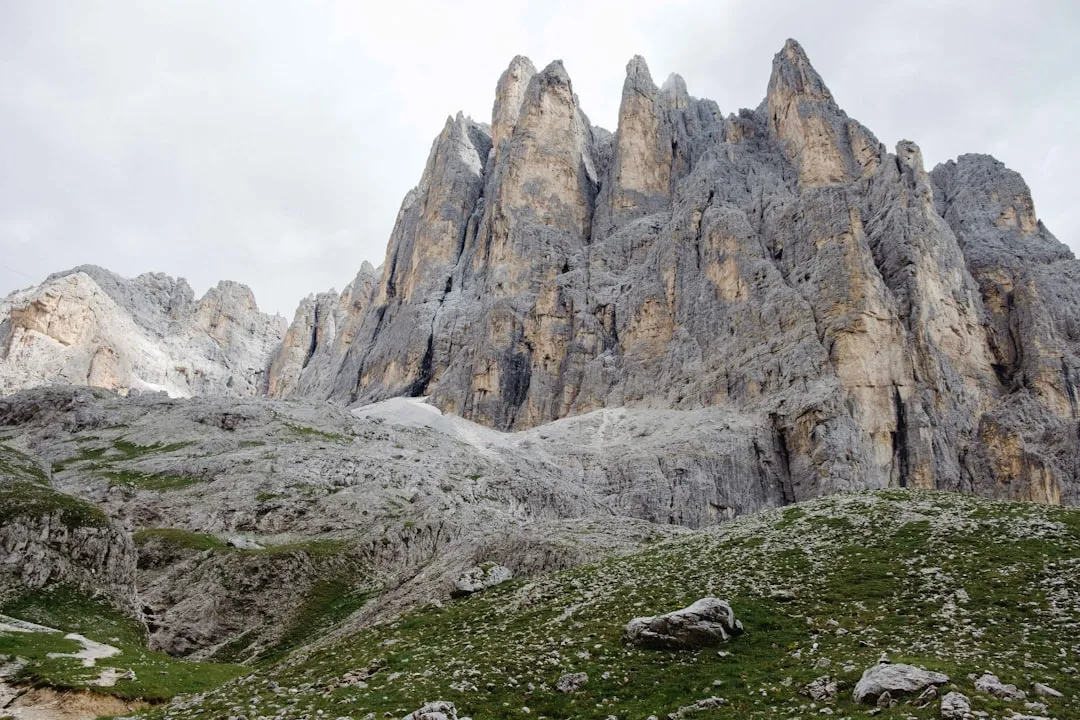
The Monte Zerbion Trail is a demanding day hike located in the Aosta Valley region of Italy, offering spectacular panoramic views from its summit. This trail is renowned for its significant elevation gain over a relatively short distance, making it a challenging but rewarding experience for fit hikers. The ascent takes you through varied terrain, from alpine meadows to rocky slopes, culminating in a breathtaking vista that encompasses the surrounding peaks of the Graian Alps, including Mont Blanc, Gran Paradiso, and the Matterhorn on clear days. It's a route that tests endurance and provides a profound sense of accomplishment upon reaching the 2,716-metre summit.
- Distance: 12.5 km one-way
- Elevation gain: 1,400 m
- Duration: 6–8 hours (round trip)
- Season: June to September (summer months, clear of snow)
- Difficulty: Challenging
- Closest City: Aosta
- Trailhead Access: Col de Joux
- Permits: Not required
Overview
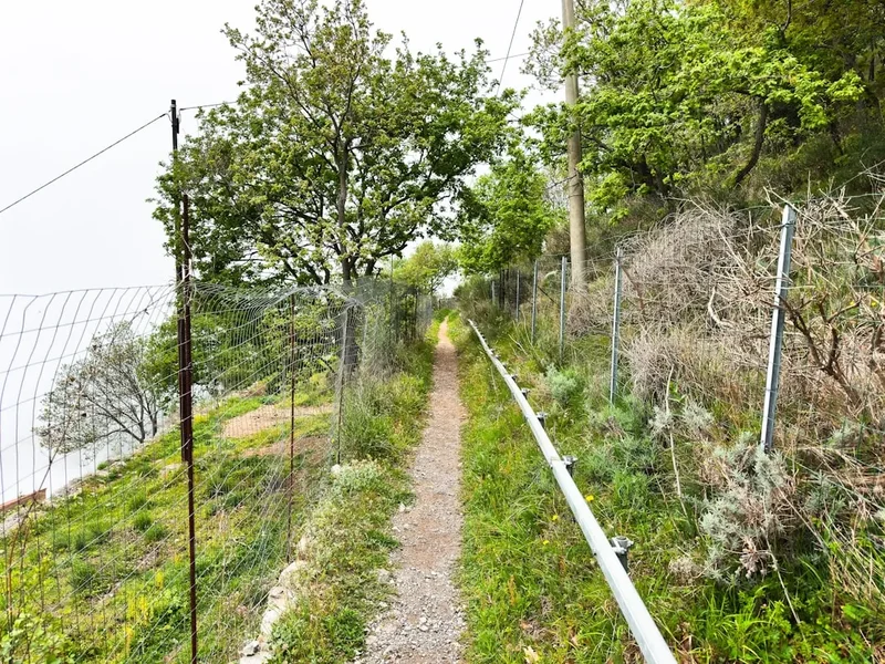
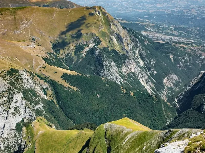
The Monte Zerbion Trail is a classic alpine day walk that epitomises the rugged beauty of the Aosta Valley. Starting from the Col de Joux (2,000 m), a mountain pass accessible by car, the trail immediately begins its relentless climb towards the summit of Monte Zerbion (2,716 m). The initial section winds through fragrant pine forests and open alpine pastures dotted with wildflowers during the summer months. As you gain altitude, the trees begin to thin, giving way to more exposed, rocky terrain. The path is well-defined but steep, requiring a good level of fitness and sure-footedness. The reward for this strenuous effort is an unparalleled 360-degree panorama from the summit. On a clear day, the views are simply magnificent, stretching across a sea of iconic peaks that define the European Alps. The descent follows the same path, offering a different perspective on the landscape you've conquered.
This hike is best undertaken during the summer months when the snow has receded from the higher elevations, typically from June through September. The weather in the mountains can be unpredictable, so it's crucial to check forecasts before setting out. The trail is popular with both locals and tourists seeking a challenging day hike with a spectacular payoff. While the ascent is demanding, the well-marked path and the sheer beauty of the surroundings make it a memorable adventure. The sense of achievement upon reaching the summit, coupled with the awe-inspiring views, makes the Monte Zerbion Trail a must-do for experienced hikers visiting the Aosta region.
History and Cultural Context
The Aosta Valley, where Monte Zerbion is located, has a rich and complex history stretching back to prehistoric times. Its strategic location in the heart of the Alps has made it a crossroads for various cultures and peoples throughout the centuries. From the indigenous Salassi tribes to Roman conquest, medieval feudalism, and its eventual integration into the Kingdom of Sardinia and later Italy, the region's heritage is deeply intertwined with its mountainous terrain.
Monte Zerbion itself, like many prominent peaks in the Alps, has likely been a landmark and a point of reference for local communities for generations. While not as historically significant as some of the major passes or ancient Roman sites in the valley, its summit would have offered an exceptional vantage point for observing weather patterns, tracking game, or simply appreciating the vastness of the landscape. The trails leading to such summits were often developed over time by shepherds, hunters, and later, by early mountaineers and hikers exploring the region.
The development of mountain huts and marked trails in the Alps gained momentum in the late 19th and early 20th centuries with the rise of alpinism and tourism. While specific historical records detailing the exact "creation" of the Monte Zerbion trail as a formal hiking route might be scarce, it is part of a network of paths that have evolved to allow access to these high-altitude viewpoints. The Col de Joux, as a road-accessible point, has facilitated easier access to the trails in its vicinity, making Monte Zerbion a more attainable objective for day hikers.
The cultural context of the Aosta Valley is also evident in the surrounding villages and the local dialect, Franco-Provençal (Patois). The agricultural traditions, particularly dairy farming and cheese production (like Fontina), are deeply rooted in the mountain environment. Hiking Monte Zerbion offers a glimpse into this landscape that has shaped the lives and culture of its inhabitants for centuries.
Seasonal Highlights and Weather Reality
The Monte Zerbion Trail is a quintessential summer alpine hike. The best period for undertaking this challenging ascent is from June to September, when the snow has typically melted from the higher sections of the trail, and the weather is generally more stable.
Summer (June to September): This is the prime season. The days are long, providing ample daylight for the 6–8 hour round trip. Alpine meadows burst into bloom with a vibrant array of wildflowers, creating a picturesque contrast to the rugged grey rock of the upper slopes. The air is crisp, and the panoramic views from the summit are often at their clearest. However, summer in the Alps also brings the possibility of afternoon thunderstorms. These can develop rapidly, bringing heavy rain, lightning, and a significant drop in temperature. It is crucial to start your hike early in the morning to avoid these potential hazards.
Spring (May): While early June might still see lingering snow at higher elevations, May is generally too early for a safe and enjoyable ascent of Monte Zerbion. Snow can persist well into June, especially on north-facing slopes, making the trail difficult to navigate and potentially dangerous without appropriate winter mountaineering equipment and experience.
Autumn (October): As autumn approaches, the landscape transforms with beautiful autumnal colours in the lower forests. However, the weather becomes increasingly unpredictable. Snowfall can occur earlier in October, and temperatures will be significantly colder. While a clear autumn day can offer stunning views, the risk of encountering snow and ice on the trail increases, making it a more challenging and potentially hazardous undertaking. It is advisable to stick to the summer months for this hike.
Winter (November to April): Monte Zerbion is completely inaccessible for hiking during the winter months due to heavy snowfall and avalanche risk. The Col de Joux road may also be closed or require snow chains. This period is strictly for experienced winter mountaineers with specialised equipment and knowledge.
Weather Considerations: Regardless of the season, mountain weather is notoriously fickle. Always check the local weather forecast specifically for the Aosta Valley and the higher elevations before you depart. Be prepared for rapid changes, including sudden drops in temperature, strong winds, and precipitation, even on seemingly clear days.
Recommended Itinerary
Monte Zerbion Day Hike Itinerary
Early Morning (Approx. 7:00 AM): Departure from Aosta
- Drive from Aosta towards Col de Joux.
- The drive takes approximately 45 minutes to 1 hour, depending on road conditions and traffic.
- Ensure your vehicle is suitable for mountain roads; they are generally paved but can be narrow and winding.
Morning (Approx. 8:00 AM): Arrival at Col de Joux and Trailhead Preparation
- Park your vehicle at the designated parking area at Col de Joux (2,000 m).
- Take time to acclimatise to the altitude.
- Final gear check: ensure you have water, snacks, appropriate clothing layers, and sun protection.
- Locate the trailhead for Monte Zerbion. The path is usually well-marked.
Morning to Midday (Approx. 8:30 AM - 12:30 PM): Ascent to Monte Zerbion Summit
- Begin the ascent. The trail is steep and direct, gaining significant elevation.
- Distance: Approximately 6.25 km to the summit.
- Elevation gain: 1,400 m.
- Time: 4–5 hours for the ascent.
- Terrain: Starts with forest paths, transitions to open alpine meadows, and finishes on rocky, scree-covered slopes.
- Key Waypoints: The trail generally follows a consistent upward trajectory, with occasional switchbacks. Look for trail markers (often red and white paint blazes or cairns).
- Take short breaks as needed to hydrate and catch your breath.
Midday (Approx. 12:30 PM - 1:30 PM): Summit Experience
- Reach the summit of Monte Zerbion (2,716 m).
- Spend time enjoying the 360-degree panoramic views.
- Identify prominent peaks such as Mont Blanc, Gran Paradiso, and the Matterhorn (weather permitting).
- Have your packed lunch and rehydrate.
- Take photographs to capture the incredible scenery.
Afternoon (Approx. 1:30 PM - 5:30 PM): Descent and Return to Col de Joux
- Begin the descent back down the same trail.
- Distance: Approximately 6.25 km.
- Elevation loss: 1,400 m.
- Time: 3–4 hours for the descent.
- Be mindful of your footing, as the descent can be hard on the knees and requires concentration, especially on loose scree.
- Continue to take breaks as needed.
Late Afternoon (Approx. 5:30 PM onwards): Return to Aosta
- Arrive back at the Col de Joux parking area.
- Drive back to Aosta.
- Consider a well-deserved meal in Aosta to celebrate your accomplishment.
Important Notes:
- This is a challenging hike requiring good physical condition.
- Start early to avoid afternoon thunderstorms and allow ample time.
- Carry sufficient water (at least 2 litres per person) as there are no reliable water sources on the upper parts of the trail.
- Wear sturdy hiking boots with good ankle support.
- Pack layers of clothing, including a waterproof and windproof jacket, as mountain weather can change rapidly.
- Sun protection (hat, sunglasses, sunscreen) is essential due to the high altitude and exposure.
- A map and compass or GPS device are recommended, although the trail is generally well-marked.
Planning and Bookings
Book Your Trip
Everything you need to plan your journey
Accommodation
Find places to stay near Aosta
Flights
Search flights to Aosta
Essential Preparation
The Monte Zerbion Trail is a demanding day hike, so thorough preparation is key to a safe and enjoyable experience. Given its challenging nature, a good level of cardiovascular fitness and leg strength is essential. The 1,400 metres of elevation gain over 12.5 km requires stamina. It is advisable to have prior hiking experience, particularly on steep terrain.
Logistics: The closest major city is Aosta, which serves as the primary base for accessing the trail. Aosta has a range of accommodation options, from hotels and guesthouses to apartments. It also offers comprehensive services, including supermarkets for purchasing food and supplies, outdoor gear shops, and transport links. The trailhead is at Col de Joux, which is accessible by car via the SR45 road from Aosta. The drive takes approximately 45 minutes to an hour. Parking is available at Col de Joux, but it can become busy during peak season, so arriving early is recommended.
Booking Coordination: As this is a day hike with no mandatory accommodation or specific transport bookings required (beyond your own travel to the region), the primary "booking" is ensuring you have the right conditions and time. This means checking weather forecasts meticulously and planning your hike for a day with clear skies and minimal wind. There are no guided tours or mandatory booking systems for this specific trail, offering flexibility.
Trail Accommodation
This is a day hike requiring no overnight accommodation.
Required Gear
- Hiking Boots: Sturdy, waterproof hiking boots with good ankle support are essential. Ensure they are well broken-in to prevent blisters.
- Backpack: A comfortable daypack (25-35 litres) to carry essentials. A rain cover for the pack is advisable.
- Clothing Layers:
- Base Layer: Moisture-wicking synthetic or merino wool top.
- Mid Layer: Fleece jacket or insulated vest for warmth.
- Outer Layer: Waterproof and windproof jacket (e.g., Gore-Tex) with a hood.
- Trousers: Durable hiking trousers, preferably quick-drying. Avoid jeans.
- Extra Warm Layer: A warm hat (beanie) and gloves are recommended, even in summer, as temperatures can drop significantly at altitude.
- Navigation:
- Map of the area and a compass.
- GPS device or smartphone with offline maps downloaded (e.g., AllTrails, Komoot, or OS Maps). Ensure your device is fully charged and consider a portable power bank.
- Safety Gear:
- First-aid kit: Including blister treatment, bandages, antiseptic wipes, pain relievers, and any personal medications.
- Head torch: With spare batteries, in case of unexpected delays or an early start/late finish.
- Emergency whistle.
- Sun protection: High SPF sunscreen, sunglasses, and a wide-brimmed hat or cap.
What to Bring
- Food: High-energy snacks such as trail mix, energy bars, fruit, and sandwiches. Pack enough for the entire duration of the hike, plus a little extra in case of delays.
- Water: Carry at least 2 litres of water per person. There are no reliable water sources on the upper sections of the trail. A water filter or purification tablets can be a useful backup, but it's best to carry all you need.
- Toiletries:
- Toilet paper and a small trowel for emergencies (if you need to go off-trail, follow Leave No Trace principles).
- Hand sanitiser.
- Any personal hygiene items.
- Other Personal Items:
- Mobile phone (fully charged).
- Camera.
- Trekking poles: Highly recommended for both the ascent and descent, as they reduce strain on knees and improve stability.
- Small plastic bags for packing out all rubbish.
Permits
No specific permits are required to hike the Monte Zerbion Trail. As a public hiking route in a national park area, access is generally free and open to all. However, it is always advisable to check local regulations or any specific park notices before your visit, especially regarding any temporary closures or restrictions that might be in place due to weather conditions or maintenance work.
The primary consideration for this hike is not a permit, but rather ensuring you have the appropriate conditions and preparation. The trail is challenging, and attempting it without adequate fitness, gear, or knowledge of mountain safety could be dangerous. Always prioritise checking the weather forecast and ensuring you are well-equipped for the conditions.
Other Activities in the Area
The Aosta Valley is rich in activities beyond hiking, offering a diverse range of experiences for visitors:
- Explore Aosta City: Discover the historical heart of the region, with its well-preserved Roman ruins, including the Arch of Augustus, the Roman Theatre, and the Porta Praetoria. The city also boasts charming medieval streets, churches, and museums.
- Visit Castles: The Aosta Valley is dotted with numerous medieval castles, each with its own history and architectural style. Popular choices include Forte di Bard (a magnificent fortress), Castello di Fénis (a picturesque fairytale castle), and Castello di Sarre.
- Gran Paradiso National Park: Located to the south of Monte Zerbion, this is Italy's oldest national park and a haven for wildlife, particularly ibex and chamois. It offers numerous hiking trails of varying difficulty, from gentle walks to challenging multi-day treks.
- Thermal Baths: Relax and rejuvenate at one of the region's thermal spas, such as those in Pré-Saint-Didier, known for their stunning mountain views and therapeutic waters.
- Skiing and Winter Sports: During the winter months, the Aosta Valley transforms into a premier destination for skiing and snowboarding, with world-class resorts like Courmayeur, Cervinia, and Pila.
- Local Gastronomy: Indulge in the delicious local cuisine, which features hearty mountain dishes, excellent cheeses (like Fontina), cured meats, and regional wines.
- Via Ferrata: For the adventurous, the Aosta Valley offers several "via ferrata" routes – protected climbing paths equipped with steel cables, rungs, and ladders, allowing less experienced climbers to ascend challenging rock faces.
Safety and Conditions
Pre-Departure Checks:
- Weather Forecast: Always check the most up-to-date mountain weather forecast for the Aosta Valley and specifically for the Monte Zerbion area. Websites like Meteo-Alpi or the Italian Air Force meteorological service are reliable sources. Be aware of potential thunderstorms, especially in the afternoon during summer.
- Trail Conditions: While the trail is generally well-maintained, conditions can change. Check local tourist information or park websites for any alerts regarding trail closures or hazards. Snow can linger on higher sections well into June.
- Road Conditions: Ensure the road to Col de Joux is open and accessible. In early spring or late autumn, check for any winter advisories or potential closures.
Altitude Sickness: Monte Zerbion's summit is at 2,716 metres. While most people can ascend to this altitude without significant issues, it's important to be aware of the symptoms of altitude sickness (headache, nausea, dizziness, fatigue). Ascend gradually, stay hydrated, and avoid alcohol and strenuous activity on the day of your hike. If symptoms worsen, descend immediately.
Terrain Hazards: The trail is steep and can be rocky, especially near the summit. Loose scree can make footing treacherous, particularly on the descent. Wear appropriate footwear and consider using trekking poles to aid stability and reduce impact on your joints.
Weather Changes: Mountain weather can change very rapidly. Be prepared for sudden shifts in temperature, wind, and precipitation. Hypothermia is a risk even in summer if you get wet and cold. Always carry waterproof and windproof outer layers, as well as warm insulating layers.
Navigation: While the trail is generally well-marked, visibility can be severely reduced in fog or cloud. Carry a map and compass and know how to use them, or rely on a reliable GPS device with offline maps. Do not rely solely on mobile phone signal, as it can be unreliable in mountainous areas.
Emergency Contacts: Save the local emergency number (112 in Italy) on your phone. Inform someone of your hiking plans, including your intended route and estimated return time.
Sun Protection: The sun's rays are stronger at higher altitudes. Use high SPF sunscreen, wear sunglasses, and a hat to protect yourself from sunburn and UV damage.
Side Trips and Points of Interest
While the Monte Zerbion Trail is primarily a direct ascent to the summit, the surrounding area offers several points of interest and potential short detours for those with extra time or energy:
Col de Joux Area: Before or after your hike, take some time to explore the immediate vicinity of Col de Joux. This mountain pass itself offers pleasant walking opportunities through alpine meadows and offers initial views of the surrounding peaks. There are often picnic areas and sometimes small cafes or refuges open during the summer season, providing a place to rest and enjoy the mountain atmosphere.
Panoramic Views from the Summit: The primary "point of interest" is, of course, the summit of Monte Zerbion itself. The 360-degree panorama is truly exceptional. On a clear day, you can identify:
- Mont Blanc Massif: The highest peak in Western Europe, visible to the west.
- Gran Paradiso: The highest peak in the Graian Alps, visible to the south.
- Matterhorn (Cervino): The iconic pyramid-shaped peak, visible to the north-west.
- Numerous other peaks of the Graian Alps and Pennine Alps.
The sheer scale of the alpine landscape from this vantage point is awe-inspiring and a significant reward for the strenuous climb.
Alpine Flora and Fauna: Keep an eye out for the diverse alpine flora that thrives in the meadows during summer. You might spot various species of wildflowers, including gentians, edelweiss (though rare), and alpine roses. If you are lucky, you may also encounter local fauna such as marmots, chamois, or ibex, particularly in the more remote sections or if you venture slightly off the main path (while staying within safe and permitted areas).
Alternative Descent Routes (for experienced hikers only): While the most common and recommended route is to descend via the same path, experienced and well-equipped hikers might explore variations. However, these are not officially marked trails and require advanced navigation skills, knowledge of the terrain, and potentially mountaineering experience. It is strongly advised for most hikers to stick to the established ascent/descent route for safety.
Leave No Trace
The Monte Zerbion Trail traverses a beautiful alpine environment that is susceptible to human impact. Adhering to Leave No Trace principles is crucial to preserving its natural beauty for future visitors and protecting the delicate ecosystem.
Your responsibility as a hiker:
- Plan Ahead and Prepare: Understand the trail's difficulty, check weather forecasts, and pack appropriate gear and sufficient supplies. This minimises the need for unexpected rescues and reduces your impact.
- Travel and Camp on Durable Surfaces: Stick to the marked trail at all times. Avoid cutting switchbacks, as this causes erosion and damages vegetation. If taking a break, choose a spot on the trail or a designated resting area.
- Dispose of Waste Properly: Pack out everything you pack in. This includes all food scraps, wrappers, tissues, and any other litter. Use designated bins at the trailhead if available, or take all waste home with you. Do not bury or burn waste.
- Leave What You Find: Do not pick wildflowers, disturb wildlife, or remove rocks or natural objects. The goal is to leave the environment as you found it.
- Minimise Campfire Impacts: Campfires are generally not permitted on day hikes and are highly discouraged in alpine environments due to the risk of wildfires and damage to vegetation. Use a portable stove if you need to cook.
- Respect Wildlife: Observe animals from a distance. Do not feed them, as this can alter their natural behaviour and diet, and can be harmful to their health.
- Be Considerate of Other Visitors: Keep noise levels down, yield to uphill hikers, and be mindful of others enjoying the natural environment.
By following these principles, you help ensure that the Monte Zerbion Trail remains a pristine and enjoyable experience for everyone.