Monte Piana Loop - A Journey Through History and High Peaks
The Monte Piana Loop is one of the most evocative and visually stunning day walks in the Italian Dolomites. Situated in the Sesto Dolomites, near the famous Tre Cime di Lavaredo, this 12.5-kilometre circuit offers a unique blend of natural grandeur and somber historical reflection. Unlike many trails that focus solely on alpine beauty, Monte Piana serves as a vast "Open Air Museum" dedicated to the First World War. The plateau was the site of some of the most brutal mountain warfare in history, where Italian and Austro-Hungarian troops faced each other at point-blank range for over two years. Today, walkers can traverse a landscape where the scars of conflict—trenches, tunnels, and bunkers—remain etched into the limestone, all while surrounded by a 360-degree panorama of the most iconic peaks in the UNESCO World Heritage Dolomites.
- Distance: 12.5 km loop
- Duration: 4–5 hours
- Elevation Gain: 450 m
- Difficulty: Moderate
- Highest Point: 2,324 m (Monte Piana South Summit)
- Best Time: June to September
- Location: Misurina, near Cortina d'Ampezzo, Belluno, Italy
Overview
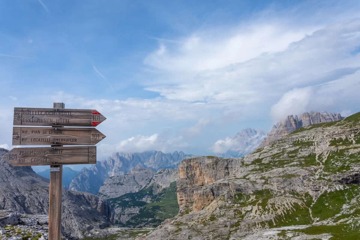
Monte Piana is a distinctive, flat-topped mountain that stands as a natural fortress between the Val d'Anciei and the Val Landro. Its unique topography—a broad, high-altitude plateau—made it a strategic prize of immense value during the Great War. The mountain is actually divided into two distinct summits: the southern peak, Monte Piana (2,324 m), which was held by the Italians, and the northern peak, Monte Piano (2,305 m), which was occupied by the Austro-Hungarians. The narrow saddle between them, known as the "Forcella dei Castrati," became a "no man's land" where thousands of lives were lost in a stalemate that lasted from 1915 to 1917.
For the modern hiker, the Monte Piana Loop provides a relatively accessible way to experience high-alpine scenery without the extreme verticality often associated with the Dolomites. The trail is well-maintained and offers a variety of terrain, from the winding military road that provides the primary access to the narrow, rocky paths that weave through the historical remains on the plateau. The visual rewards are unparalleled; from the summit, the Tre Cime di Lavaredo appear so close you feel you could touch them, while the Cadini di Misurina needles, the massive bulk of Monte Cristallo, and the red-tinged walls of Croda Rossa d'Ampezzo frame the horizon in every direction.
The experience is deeply atmospheric. Walking through the restored trenches, one can still see the firing slits and the cramped quarters where soldiers endured sub-zero temperatures and constant shelling. The contrast between the peaceful, wildflower-strewn meadows of the plateau and the violent history they conceal is profound. This is not just a hike; it is a pilgrimage through a landscape of memory, offering a sobering perspective on the resilience of the human spirit amidst the indifference of the mountains.
History and Cultural Context
The history of Monte Piana is inextricably linked to the "War of the Mines" and the "White War" of 1915–1917. When Italy entered the First World War against the Austro-Hungarian Empire, the Dolomites became a vertical front line. Monte Piana was chosen as a primary defensive position because it commanded the entrance to the Val Pusteria and the road to Dobbiaco. The Italian "Brigata Como" and "Brigata Umbria" were tasked with holding the southern plateau, while the Austro-Hungarian "Kaiserjäger" fortified the northern end.
The conditions were horrific. Soldiers lived in "baracche" (wooden huts) clinging to the cliffs or in tunnels bored directly into the rock. In winter, the greatest enemy was often not the opposing army, but the elements. Avalanches, frostbite, and the "White Death" claimed as many lives as bullets. The plateau is still crisscrossed by kilometres of trenches, many of which have been meticulously restored by the "Friends of Monte Piana" (Amici del Monte Piana), a volunteer organisation dedicated to preserving the site as a monument to peace. As you walk, you will encounter the "Capanna Carducci," a small stone hut named after the poet Giosuè Carducci, who visited the mountain before the war, and various monuments dedicated to the fallen of both sides.
Culturally, the mountain represents the shared heritage of the Ladin, Italian, and German-speaking populations of the region. The "Open Air Museum" serves as a reminder of the futility of the conflict that once tore these communities apart. Today, the border that was once fought over so bitterly is merely a line on a map, and Monte Piana stands as a symbol of European reconciliation, where hikers from all nations walk the same paths in peace.
Want more background? Read extended notes on history and cultural context → Learn more
Seasonal Highlights and Weather Reality
The hiking season on Monte Piana is strictly dictated by snowmelt and the opening of the mountain refuges. Generally, the trail is accessible from early June through to late September or early October, depending on the year's snowfall.
Spring (June): This is the time for wildflowers. The plateau erupts in a carpet of alpine flora, including gentians, edelweiss, and mountain avens. However, patches of snow may still linger in the deeper trenches and on the northern slopes of Monte Piano, requiring careful footwork. The air is crisp, and the visibility is often at its peak.
Summer (July and August): This is the most popular time to visit. The weather is generally stable, with warm days and cool nights. However, the Dolomites are famous for their afternoon thunderstorms. It is essential to start early to avoid being caught on the exposed plateau when lightning strikes. The shuttle service from Misurina operates at full frequency during these months.
Autumn (September to early October): Many hikers consider this the best time for the Monte Piana Loop. The crowds thin out, the air becomes exceptionally clear, and the larch trees in the valleys below begin to turn a brilliant gold. The temperatures are cooler, making the ascent more comfortable, though you must be prepared for the possibility of early-season dusting of snow.
Winter (November to May): The trail is not recommended for standard hiking. The plateau becomes a serious mountaineering environment subject to high avalanche risk. While snowshoeing is possible for the experienced, the historical features are buried under metres of snow, and the Rifugio Bosi is typically closed.
Recommended Itinerary
Monte Piana Loop Route Progression
Phase 1: The Ascent from Misurina to Rifugio Bosi
- Distance: 6 km (if walking the road) or 0 km (if taking the shuttle)
- Elevation gain: 450 m
- Time: 1.5–2 hours (walking) or 20 minutes (shuttle)
- The journey begins at the parking area near Lake Misurina.
- You can choose to walk up the old military road (closed to private traffic) or take the dedicated Jeep shuttle service.
- The road winds through larch and pine forests, offering increasing views of the Cadini di Misurina.
- Arrive at Rifugio Angelo Bosi (2,205 m), the base for the loop and a former military command post.
Phase 2: The Southern Plateau (Italian Lines)
- Distance: 2.5 km
- Elevation gain: 120 m
- Time: 1 hour
- From Rifugio Bosi, follow the signs for the "Museo all'aperto."
- The path climbs gently onto the southern plateau of Monte Piana.
- Explore the first set of restored trenches and the "Capanna Carducci."
- Reach the South Summit (2,324 m), marked by a large cross and a 360-degree orientation table.
- The view of the Tre Cime di Lavaredo from here is considered one of the best in the Dolomites.
Phase 3: Forcella dei Castrati and Monte Piano (Austrian Lines)
- Distance: 2 km
- Elevation gain: 50 m
- Time: 1 hour
- Descend slightly into the Forcella dei Castrati, the narrow saddle separating the two peaks.
- Cross into the northern sector, known as Monte Piano (the Austrian side).
- The terrain here is more rugged, with deep galleries and tunnels carved into the cliff faces.
- Visit the Austrian monument and the various commemorative plaques.
- The views to the north look down into the Val Landro and across to the Croda Rossa.
Phase 4: The Perimeter Return and Descent
- Distance: 2 km
- Elevation: Mostly level with a final descent
- Time: 1 hour
- Follow the perimeter path along the western edge of the plateau for dramatic views of Monte Cristallo.
- The trail loops back toward the Forcella dei Castrati and rejoins the main path to Rifugio Bosi.
- Take time to visit the small chapel near the refuge dedicated to the fallen.
- Return to Misurina via the shuttle or by walking back down the military road.
Important Notes:
- The plateau is highly exposed; there is no shade or shelter once you leave Rifugio Bosi.
- The "Sentiero Storico" (Historical Path) involves some narrow sections near cliff edges; caution is required.
- Allow extra time for exploring the tunnels—a head torch is highly recommended.
- The shuttle service is a paid service and operates on demand during the day.
Planning and Bookings
Book Your Trip
Everything you need to plan your journey
Accommodation
Find places to stay near Cortina d'Ampezzo
Flights
Search flights to Cortina d'Ampezzo
Essential Preparation
Planning for the Monte Piana Loop is relatively straightforward compared to multi-day treks, but several logistical details ensure a smooth experience. The primary base for this hike is the village of Misurina, located at 1,754 metres. Misurina is easily reached from Cortina d'Ampezzo (20 minutes) or Dobbiaco (25 minutes). If you are driving, arrive early during the peak summer months (July and August), as parking near the lake and the shuttle departure point fills up quickly.
Fitness requirements are moderate. While the elevation gain is not extreme, the terrain on the plateau is rocky and uneven. Walkers should be comfortable with heights, as some sections of the perimeter path run close to significant drops. If you choose to walk the access road from Misurina rather than taking the shuttle, add an extra 450 metres of vertical gain and approximately 3 hours to your total round-trip time.
Trail Accommodation
As a day hike, most visitors do not require overnight accommodation on the mountain itself. However, staying at the refuge can be a magical experience, allowing you to witness sunrise and sunset over the Tre Cime in near-total solitude.
Rifugio Angelo Bosi:
- Located at the end of the military road at 2,205 m.
- Provides dormitory-style bunk beds and a limited number of private rooms.
- Facilities include a restaurant serving traditional Tyrolean and Italian mountain fare, a bar, and public toilets.
- Booking is essential for overnight stays, especially in August.
- The refuge is typically open from mid-June to late September.
- Electricity is available, but water is a precious resource; showers may be limited or incur a fee.
Misurina and Surroundings:
- The village of Misurina offers several hotels ranging from 3-star to 4-star, as well as campsites near the lake.
- Cortina d'Ampezzo provides a wider range of luxury hotels, apartments, and hostels.
- For those on a budget, the nearby Val di Landro has several well-equipped campsites.
Required Gear
- Footwear: Sturdy hiking boots with good ankle support and Vibram-style soles are essential. The limestone on the plateau can be sharp and slippery when wet.
- Clothing: The layering system is key. Even in summer, temperatures on the plateau can drop rapidly if a cloud moves in. Bring a moisture-wicking base layer, a fleece or down mid-layer, and a high-quality waterproof shell.
- Head Torch: Essential if you plan to explore the WWI tunnels and galleries, which are pitch black and can be quite deep.
- Sun Protection: The plateau is highly reflective and completely exposed. Bring a wide-brimmed hat, high-SPF sunscreen, and category 3 or 4 sunglasses.
- Navigation: A physical map (Tabacco Map 03: Cortina d'Ampezzo e Dolomiti Ampezzane) is recommended, though the main trails are well-marked with CAI (Club Alpino Italiano) signage.
What to Bring
- Water: There are no natural water sources on the plateau. Carry at least 2 litres per person. You can refill bottles at Rifugio Bosi (though they may charge for bottled water if the spring is low).
- Food: While Rifugio Bosi offers excellent meals, bring high-energy snacks (nuts, dried fruit, chocolate) for the loop itself. A picnic on the North Summit with views of the Tre Cime is a highlight.
- First Aid: A basic kit including blister plasters (moleskin), antiseptic wipes, and any personal medications.
- Cash: The shuttle service and Rifugio Bosi may have unreliable card machines due to the remote location. Carry enough Euros for the shuttle (approx. €15-20 return) and a meal.
- Camera/Binoculars: The bird's-eye view of the surrounding peaks and the historical details of the trenches are worth capturing and inspecting closely.
Permits
One of the advantages of the Monte Piana Loop is that no permits or formal registrations are required to hike the trail. The mountain is part of the public domain within the Belluno Dolomites, and access is free to all.
Associated Costs:
- Parking: If you park at the designated lot in Misurina (near the Genzianella hotel), expect to pay a daily fee, typically between €10 and €15 during the high season.
- Shuttle Service: The Jeep shuttle from Misurina to Rifugio Bosi is a private service. As of the latest season, the cost is approximately €10 for a one-way trip or €15–20 for a return journey. The shuttle saves 450 m of climbing and is highly recommended if you want to spend more time exploring the historical features on the plateau.
- Toll Road (Optional): If you are also visiting the nearby Tre Cime di Lavaredo (Rifugio Auronzo) on the same trip, be aware that the toll road to Auronzo is expensive (approx. €30 per car). Monte Piana is a separate access point and does not require this toll.
Regulations:
- Camping is strictly prohibited on the plateau to protect the historical site and the fragile alpine environment.
- Drones are generally restricted in this area of the Dolomites to preserve the peace and protect local birdlife; check current local ENAC regulations before flying.
- Stay on the marked paths; the plateau is a memorial site, and wandering off-trail can damage historical remains or lead to dangerous cliff edges.
Other Activities in the Area
The area surrounding Monte Piana is the heart of the Dolomites, offering a wealth of other world-class experiences:
- Tre Cime di Lavaredo Circuit: The most famous hike in the Dolomites is just a short drive away. The 10 km loop around the three peaks is a must-do, though it is significantly more crowded than Monte Piana.
- Cadini di Misurina Viewpoint: A short but dramatic hike from Rifugio Auronzo leads to the "Punto Panoramico," offering a jagged, "Lord of the Rings" style view of the Cadini needles.
- Lago di Misurina: Known as the "Pearl of the Dolomites," the lake is perfect for a gentle stroll, a pedal-boat ride, or simply enjoying a gelato while admiring the reflection of the Sorapiss massif.
- Via Ferrata: For the more adventurous, the nearby Via Ferrata Innerkofler on Monte Paterno provides a thrilling way to explore WWI tunnels and reach a spectacular summit overlooking the Tre Cime.
- Cortina d'Ampezzo: Visit the glamorous mountain town for high-end shopping, excellent dining, and to see the venues for the upcoming 2026 Winter Olympics.
- Lago di Braies: Located about 45 minutes away, this iconic emerald lake is one of the most photographed spots in Italy (best visited very early in the morning).
Safety and Conditions
Weather Awareness: The most significant danger on Monte Piana is the weather. The plateau is a lightning magnet. If you see dark clouds building or hear thunder, descend immediately to Rifugio Bosi. Do not wait for the rain to start. Temperatures can also plummet within minutes during a storm, leading to a risk of hypothermia if you are not carrying appropriate layers.
Terrain Hazards: While the trail is not technically difficult, it is rocky. Twisted ankles are the most common injury. Furthermore, the plateau is surrounded by sheer cliffs. While the main paths are safe, some of the historical trenches lead directly to "observatory" points on the edge of the precipice. Always supervise children closely and stay behind any installed railings.
Historical Hazards: The WWI remains are over a century old. While the "Friends of Monte Piana" maintain the site, some tunnels may be unstable or contain standing water. Never enter a tunnel that looks collapsed or is marked as closed. Use a reliable light source; the floors of the galleries can be uneven with unexpected steps or holes.
Hydration and Exposure: There is zero shade on the plateau. Heat exhaustion and dehydration are real risks in July and August. Wear a hat, use sunscreen, and drink water regularly, even if you don't feel thirsty.
Emergency Contacts: The European emergency number is 112. Mountain Rescue (Soccorso Alpino) can be reached through this number. Be prepared to provide your GPS coordinates, which are often posted on trail signs.
Side Trips and Points of Interest
The Austrian Pyramid: Located on the northern summit (Monte Piano), this stone pyramid is a monument to the Austro-Hungarian soldiers. It serves as a poignant counterpart to the Italian monuments on the southern side and offers a commanding view of the Val di Landro far below.
The Bell of Peace: Near the Forcella dei Castrati, a large bell has been installed. It is often rung by hikers as a symbolic gesture of peace and remembrance. The sound echoing across the quiet plateau is a moving experience.
Galleria del Comando: This is one of the most impressive tunnel complexes on the mountain. It served as a command centre and provides a chilling look at the scale of the engineering required to sustain a war at this altitude. A head torch is mandatory for exploration.
The "Sentiero dei Turisti": For those who prefer a more challenging ascent than the military road, this path climbs the western face of the mountain. It is steeper and more rugged but offers a more "wild" approach to the plateau, passing through beautiful rock formations and offering constant views of the Cristallo group.
The Toblach Viewpoint: From the northernmost tip of Monte Piano, you can look straight down the valley toward the town of Dobbiaco (Toblach). On a clear day, you can see the green pastures of the Pusteria Valley contrasting with the grey limestone of the peaks.
Leave No Trace
Monte Piana is not only a natural treasure but a sacred historical site. It is essential that every visitor adheres to the strictest Leave No Trace principles to preserve the integrity of the "Open Air Museum" and the fragile alpine tundra.
Specific Guidelines for Monte Piana:
- Respect the Ruins: Do not move stones, remove artifacts (such as old rusted wire or shrapnel), or deface the walls of the bunkers and trenches. These are historical records that belong to everyone.
- Pack It In, Pack It Out: There are no bins on the plateau. Take all your rubbish, including organic waste like apple cores and banana peels, back down to Misurina.
- Stay on the Path: The alpine soil is thin and easily eroded. Walking off-trail destroys rare plants and contributes to the scarring of the landscape.
- No Toileting on the Plateau: The rocky ground makes it impossible to bury waste properly, and the lack of soil means waste does not decompose. Use the facilities at Rifugio Bosi or in Misurina before you start.
- Wildlife: You may encounter marmots or chamois. Observe them from a distance and never attempt to feed them.
- Silence: Many people visit Monte Piana for reflection. Keep noise levels low and avoid using speakers.