
Monte Perdido Circuit - The Limestone Crown of the Pyrenees
The Monte Perdido Circuit is a high-altitude odyssey through the heart of the Ordesa y Monte Perdido National Park, a UNESCO World Heritage site located in the Spanish Pyrenees. Spanning approximately 55 kilometres with a staggering 3,500 metres of vertical gain, this trek is widely considered one of the most spectacular and geologically significant mountain routes in Europe. The circuit orbits the massive limestone block of Monte Perdido (3,355 m), the third-highest peak in the Pyrenees and the highest limestone massif on the continent. Walkers traverse a landscape of profound contrasts: from the deep, verdant canyons of Ordesa and Añisclo, which resemble the scale of the Grand Canyon, to the stark, lunar-like karst plateaus and the permanent glaciers of the north face. This is a journey through a vertical world where bearded vultures soar over 1,000-metre cliffs and ancient glacial cirques form natural amphitheatres of staggering proportions. The route is demanding, requiring physical stamina and a head for heights, but it rewards the adventurous with some of the most dramatic alpine scenery found anywhere in the world.
- Distance: 55.0 km loop
- Duration: 4–5 days
- Elevation Gain: 3,500 m
- Difficulty: Challenging (High-altitude terrain, steep ascents, and technical sections)
- Best Time: June to September (Snow can persist on high passes until late July)
- Highest Point: 2,800 m (Brecha de Rolando) or 3,355 m (if summiting Monte Perdido)
- Closest City: Torla-Ordesa, Spain
- Accommodation: High-altitude mountain refugios (mandatory booking)
Overview
The Monte Perdido Circuit is not merely a hike; it is a masterclass in mountain geology and biodiversity. The Ordesa y Monte Perdido National Park, established in 1918, is one of the oldest protected areas in Europe, and the circuit allows walkers to experience its four distinct valleys: Ordesa, Pineta, Escuaín, and Añisclo. Each valley possesses a unique character, shaped by the relentless forces of glaciation and erosion on the soft limestone bedrock. The Ordesa Valley, the most famous of the four, is a classic U-shaped glacial trough, bounded by vertical walls that rise over 800 metres from the valley floor. In contrast, the Añisclo Canyon is a narrow, deep fissure carved by the Bellos River, showcasing the power of fluvial erosion.
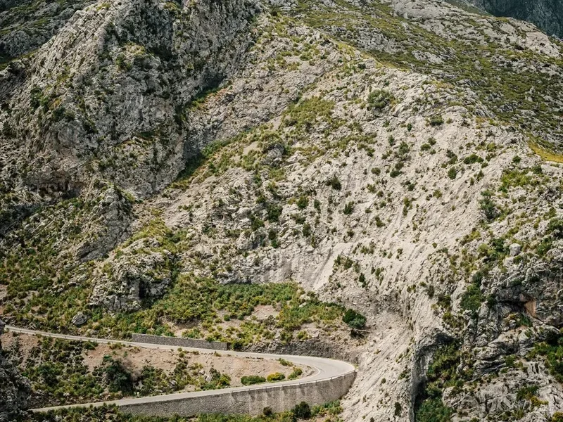
The circuit typically begins in the medieval village of Torla, the gateway to the park. From here, walkers ascend into the high mountains, leaving the lush beech and silver fir forests behind as they climb onto the alpine meadows (majadas) and eventually the high-altitude desert of the karst plateaus. The terrain is notoriously rugged; limestone is porous, meaning water often disappears into subterranean cave systems, leaving the surface dry, sharp, and technically demanding to navigate. One of the most iconic features of the route is the "Fajas"—natural horizontal ledges carved into the cliff faces that provide narrow but walkable paths with hundreds of metres of exposure beneath one's boots.
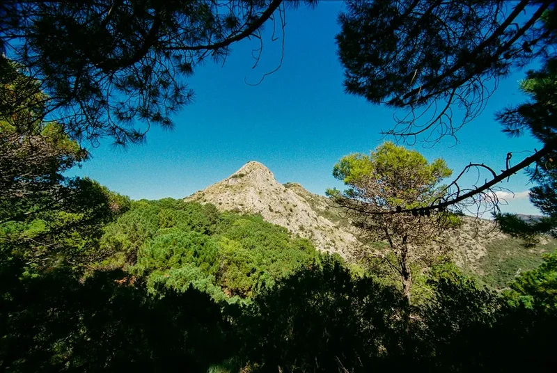
The biological diversity of the circuit is equally impressive. The park is a stronghold for the Gypaetus barbatus (bearded vulture or lammergeier), a magnificent raptor with a nearly three-metre wingspan that feeds on bone marrow. Walkers frequently encounter Pyrenean chamois (sarrios) skipping across scree slopes and marmots whistling from the meadows. The flora is equally specialised, with the delicate Edelweiss and the endemic Pyrenean Violet clinging to rocky crevices. This circuit is a journey of constant elevation change, where every hour brings a new perspective on the "Lost Mountain" (Monte Perdido) and the surrounding peaks of the Marboré range.
History and Cultural Context
The history of the Monte Perdido massif is a blend of local pastoral traditions and the golden age of Pyrenean exploration. For centuries, the high pastures were the exclusive domain of shepherds from the valleys of Broto and Vió in Spain, and the Gavarnie valley in France. These shepherds established the "puertos" or high passes, moving their livestock across the border in a seasonal rhythm known as transhumance. The "Brecha de Rolando" (Roland's Breach), a massive 40-metre wide, 100-metre high natural gap in the cliff wall on the border between Spain and France, is central to local legend. According to the 11th-century "Song of Roland," the Frankish knight Roland attempted to destroy his sword, Durendal, to prevent it from falling into enemy hands after the Battle of Roncevaux Pass. His blow instead sliced through the mountain, creating the breach.
Scientific and mountaineering interest in the area surged in the late 18th and 19th centuries. Louis Ramond de Carbonnières, a French botanist and geologist, is credited with the first recorded ascent of Monte Perdido in 1802. His writings and sketches brought the "limestone giant" to the attention of the European scientific community. However, it was the French photographer and writer Lucien Briet who truly popularised the Ordesa Valley. In the early 20th century, Briet’s stunning photographs and passionate advocacy for the preservation of the canyon were instrumental in the Spanish government’s decision to declare Ordesa a National Park in 1918.
The cultural heritage of the region is also reflected in the architecture of the base towns like Torla. The stone houses with their "espantabrujas" (witch-scaring chimneys) and the fortified church reflect a history of border tensions and a deep-seated connection to the rugged landscape. Today, the circuit is a symbol of cross-border cooperation, as the UNESCO World Heritage site encompasses both the Spanish National Park and parts of the French Pyrenees National Park, recognising the shared geological and cultural history of the "Pyrénées - Mont Perdu" landscape.
Want more background? Read extended notes on history and cultural context → Learn more
Seasonal Highlights and Weather Reality
The window for completing the full Monte Perdido Circuit is relatively narrow due to the high altitude and the technical nature of the passes. The primary season runs from mid-June to late September. Outside of these months, the route becomes a serious mountaineering undertaking requiring ice axes, crampons, and advanced winter navigation skills.
Summer (July and August): This is the peak season. The weather is generally stable, with warm days and cool nights. However, the Pyrenees are notorious for afternoon thunderstorms (tormentas). These can develop rapidly, bringing heavy rain, lightning, and a sudden drop in temperature. Walkers should aim to cross high passes and reach their destination by early afternoon to avoid the worst of these storms. This is also the time when the alpine flowers are in full bloom, and the "Escupidera" (the final couloir to the summit of Monte Perdido) is usually clear of dangerous ice, though a small snow patch often remains.
Shoulder Season (June and September): June is a beautiful month as the valleys are vibrant green and the waterfalls are at their maximum flow from snowmelt. However, high passes like the Collado de Añisclo or the Brecha de Rolando may still be blocked by steep snow slopes, requiring technical gear. September offers crisp air, stable weather, and the beginning of autumn colours in the beech forests. The crowds of August have thinned, making the refugios much quieter. Night-time temperatures can drop below freezing at the higher huts during this time.
Winter and Spring (October to May): The circuit is covered in deep snow, and avalanche risk is a significant concern, particularly in the Ordesa and Pineta valleys. The Refugio de Góriz remains open year-round, but reaching it requires expert winter mountaineering experience. Many of the other huts on the circuit may be closed or operate only as unstaffed winter shelters with very basic facilities.
Recommended Itinerary
4-Day Monte Perdido Circuit Itinerary
Day 1: Torla/Pradera de Ordesa to Refugio de Góriz
- Distance: 12 km
- Elevation gain: 900 m
- Time: 5–6 hours
- Start at the Pradera de Ordesa (accessible by shuttle bus from Torla)
- Ascend via the "Senda de los Cazadores" (Hunters' Path) for a steep but rewarding climb to the Calcilarruego viewpoint
- Traverse the "Faja de Pelay," a spectacular high-level ledge offering bird's-eye views of the Ordesa Canyon
- Pass the "Cola de Caballo" (Horsetail Fall) at the head of the valley
- Final ascent via the "Clavijas de Soaso" (iron pegs) or the longer mule track to reach the hut
- Arrive at Refugio de Góriz (2,200 m), the most iconic hut in the Pyrenees
Day 2: Refugio de Góriz to Refugio de Pineta
- Distance: 14 km
- Elevation: 600 m gain, 1,200 m descent
- Time: 7–8 hours
- Traverse the high karst plateaus beneath the peaks of the Marboré range
- Ascend to the Collado de Añisclo (2,453 m), a dramatic pass between the Pineta and Añisclo valleys
- Experience the "Fuen Blanca," a massive waterfall emerging directly from the cliff face
- Begin the long, knee-jarring descent into the Pineta Valley
- The descent is steep and requires careful footwork on loose limestone scree
- Arrive at Refugio de Pineta (1,240 m) located on the valley floor near the head of the Cinca River
Day 3: Refugio de Pineta to Refugio de Espuguettes (France)
- Distance: 13 km
- Elevation: 1,250 m gain, 400 m descent
- Time: 7–8 hours
- A challenging day crossing the border into France
- Steep ascent from the Pineta Valley floor towards the Balcón de Pineta
- Pass the Marboré Lake and the remnants of the Monte Perdido glacier
- Cross the border at the Puerto de Lavedan or the Hourquette d'Alans
- Enter the French Pyrenees National Park with views of the Cirque de Estaubé
- Arrive at Refugio de Espuguettes (2,027 m), offering a legendary view of the Cirque de Gavarnie
Day 4: Refugio de Espuguettes to Torla via Brecha de Rolando
- Distance: 16 km
- Elevation: 800 m gain, 1,500 m descent
- Time: 8–9 hours
- Descend towards the village of Gavarnie before ascending towards the Sarradets Hut
- Climb the final steep scree slope to the Brecha de Rolando (2,807 m), the iconic gateway back into Spain
- Descend through the "Aguas Tuertas" and the Cotatuero basin
- Option to descend the "Clavijas de Cotatuero" (exposed iron pegs) or the bypass route
- Final long descent through the beech forests back to the Pradera de Ordesa
- Take the shuttle bus back to Torla for a well-earned celebration
Important Notes:
- The itinerary can be extended to 5 days by adding a summit attempt of Monte Perdido from Refugio de Góriz
- Refugio bookings are essential and should be made months in advance
- The "Clavijas" (iron pegs) sections are exposed; a via ferrata kit is recommended for those uncomfortable with heights
- Water is scarce on the high plateaus; carry at least 3 litres per day
- The descent into Pineta is exceptionally steep; trekking poles are highly recommended
Planning and Bookings
Book Your Trip
Everything you need to plan your journey
Accommodation
Find places to stay near Torla
Flights
Search flights to Torla
Essential Preparation
The Monte Perdido Circuit is a serious mountain undertaking that requires a high level of physical fitness and previous experience in alpine environments. You will be carrying a multi-day pack over steep, rocky terrain with significant elevation changes. Training should focus on cardiovascular endurance and leg strength, ideally including hikes with similar elevation profiles. Coordination is key: you must align your transport to Torla with your refugio reservations. Torla-Ordesa is the primary base town. It is a well-equipped village with hotels, gear shops, and supermarkets. During the summer months (July–August), private vehicle access to the Pradera de Ordesa (the trailhead) is restricted, and you must use the frequent shuttle bus service that departs from the large car park in Torla.
Trail Accommodation
Accommodation on the circuit consists of high-altitude mountain refugios. These are staffed during the summer and provide a communal mountain experience. Because this is a popular route, booking is not just recommended—it is mandatory. If you arrive without a booking, you may be turned away, and camping is strictly regulated within the National Park.
Refugios on the Route:
- Refugio de Góriz: The most popular hut. Offers bunks, meals, and a small shop. It is the base for Monte Perdido summit attempts. Facilities include toilets and cold water. Hot showers are sometimes available for a fee but are often restricted due to water scarcity.
- Refugio de Pineta: Located on the valley floor. It is more accessible and offers slightly more comfort, including better shower facilities and road access.
- Refugio de Espuguettes (France): A classic French hut with incredible views of the Gavarnie Cirque. Known for excellent communal dinners.
- Refugio de Sarradets (France): Located right below the Brecha de Rolando. Useful if the weather turns or if you want to split the final day.
What is Provided: Bunk beds with mattresses and blankets (though a silk liner is required), breakfast, packed lunches (if ordered), and multi-course communal dinners. What is NOT Provided: Towels, toiletries, personal lighting, or charging ports (some huts have limited solar charging, but do not rely on it). Costs typically range from €45 to €60 per night for half-board (dinner, bed, and breakfast).
Required Gear
- Mountain boots: Sturdy, waterproof, and with a high-grip sole (Vibram or similar) for limestone.
- Clothing: Layering system including moisture-wicking base layers, a fleece or down mid-layer, and a high-quality waterproof/breathable shell jacket.
- Navigation: Topographic map (1:25,000 scale), compass, and a GPS device or smartphone with offline maps (e.g., Gaia GPS or AllTrails).
- Safety: A basic via ferrata kit (harness and lanyard) if you plan to use the Cotatuero or Soaso iron pegs.
- Sun protection: High SPF sunscreen, lip balm with UV protection, and Category 3 or 4 sunglasses (essential for snow patches and high-altitude glare).
- Backpack: 35–45 litre pack with a proper suspension system and rain cover.
- Trekking poles: Essential for saving your knees on the 1,000m+ descents.
What to Bring
- Water treatment: While hut water is generally safe, a lightweight filter (like a Sawyer Squeeze) or purification tablets are necessary for stream water, which may be contaminated by livestock.
- Food: High-energy snacks (nuts, dried fruit, energy bars). While huts provide meals, you need fuel for the 7–9 hour trekking days.
- Personal items: A silk or cotton sleeping bag liner (mandatory in huts), earplugs (for communal dorms), and a lightweight travel towel.
- First aid: Blister kits (Compeed), painkillers, antiseptic wipes, and any personal medications.
- Emergency: A lightweight emergency bivy bag or space blanket and a whistle.
- Head torch: With spare batteries for early starts or navigating the hut at night.
Permits

Currently, no specific "hiking permit" is required to walk the Monte Perdido Circuit. However, the "permit" in practice is your refugio reservation. Because wild camping is heavily restricted, your ability to legally complete the circuit depends entirely on securing a bed in the huts. For Refugio de Góriz, it is common for the entire summer season to be booked out within days of the reservation system opening in the spring.
Camping Regulations:
- In the Spanish National Park (Ordesa), "high-altitude bivouacking" is permitted only above 2,100 m (in the Ordesa sector) or 2,500 m (in other sectors).
- Tents must be pitched at sunset and taken down at sunrise.
- Camping is strictly prohibited near the refugios unless the hut is full and the warden gives specific permission in a designated area.
- In the French Pyrenees National Park, bivouacking is allowed more than one hour's walk from the park boundaries or road access, between 7:00 PM and 9:00 AM.
Booking Strategy: Visit the official "Federación Aragonesa de Montañismo" (FAM) website or the specific refugio websites (e.g., goriz.es) as early as January or February to check for opening dates. If you are travelling in a group, booking early is non-negotiable. If the huts are full, consider checking for cancellations 48 hours before your start date, as some spots occasionally open up.
Other Activities in the Area
The region surrounding Torla and the Ordesa Valley offers a wealth of activities for those with extra time or for those looking to recover after the circuit:
- Canyoning in the Sierra de Guara: Located a few hours south, this is the world capital of canyoning, featuring turquoise pools and dramatic limestone narrows.
- Village Hopping: Explore the stone-built villages of the Sobrarbe region, such as Aínsa, which features a stunning medieval plaza and castle.
- Via Ferrata: There are several dedicated via ferrata routes near Broto (e.g., Cascada del Sorrosal) that offer thrilling vertical climbs next to massive waterfalls.
- White Water Rafting: The Ara River, the last "wild" river in the Pyrenees without dams, offers world-class rafting during the spring snowmelt (May–June).
- Gavarnie Falls: If you cross into France, a visit to the base of the Grande Cascade de Gavarnie (422 m) is a must. It is one of the highest waterfalls in Europe.
- Photography: The "Miradores de Ordesa" (viewpoints) can be reached via 4x4 taxi tours from Torla, providing spectacular sunset photography opportunities without the 1,000 m climb.
Safety and Conditions
The Monte Perdido Circuit is a high-alpine environment where conditions can change from benign to life-threatening in a matter of minutes. Safety must be your primary concern.
The "Escupidera" Danger: If you choose to summit Monte Perdido, be aware of the "Escupidera" (the Spittoon). This is a steep, tilted couloir on the final ascent. In early summer, it is covered in hard snow. A slip here without an ice axe and the knowledge of how to self-arrest is often fatal, as the slope "spits" fallen climbers over a vertical cliff. Do not attempt the summit in early season without proper gear and experience.
Weather Awareness: Afternoon thunderstorms are the greatest objective hazard in summer. Lightning is a very real threat on the exposed karst plateaus and high passes. If you see dark, towering cumulus clouds forming, descend from ridges immediately. Always check the AEMET (Spanish Meteorological Agency) mountain forecast before leaving the hut.
Terrain and Navigation: The limestone terrain is exceptionally sharp and can shred boots and skin. In fog, the karst plateaus become a navigational nightmare, as there are few distinct landmarks and the grey rock looks identical in every direction. Always carry a GPS with a backup map and compass. The "Clavijas" (iron pegs) at Soaso and Cotatuero are very exposed. While many experienced hikers do them without a harness, a fall would be fatal. If you have any doubt, use the bypass routes or a via ferrata kit.
Hydration and Heat: The high plateaus are a "cold desert." The sun is intense, and there is very little shade. Heat exhaustion is common. Conversely, even in August, a storm can bring sleet and near-freezing temperatures, making hypothermia a risk for those without proper waterproof layers.
Side Trips and Points of Interest
Summit of Monte Perdido (3,355 m): The most popular side trip. From Refugio de Góriz, it takes approximately 3–4 hours to reach the summit. The view from the top encompasses the entire Pyrenean chain, from the Atlantic to the Mediterranean peaks. The route passes the "Lago Helado" (Frozen Lake), which often remains ice-covered well into July.
Faja de las Flores: Often cited as the most spectacular path in the Pyrenees. This is a narrow, natural ledge located high above the Ordesa Valley floor. It is only 3 kilometres long but sits at an altitude of 2,400 m, offering terrifyingly beautiful views. Accessing it requires climbing the Clavijas de Cotatuero or Carriata.
Brecha de Rolando (Roland's Breach): Even if you don't follow the French itinerary, a hike to the Breach from Góriz is a highlight. Standing in the 40-metre wide gap between two countries is a profound experience. Nearby is the "Cueva de Casteret," an ice cave of great geological interest (though entry is restricted to protect the ice formations).
Cola de Caballo: The "Horsetail Fall" is the iconic image of Ordesa. While it is on the main route, taking the time to sit at its base and watch the water fan out over the limestone steps is a quintessential part of the journey. In the early morning, you may have it to yourself before the day-hikers arrive from the valley floor.
Leave No Trace
The Ordesa y Monte Perdido National Park is a fragile ecosystem under significant pressure from tourism. Adhering to Leave No Trace principles is essential to maintaining the UNESCO status of this landscape.
Specific Park Rules:
- No Swimming: Swimming in alpine lakes (ibones) or rivers is strictly prohibited. Sunscreen and skin oils disrupt the delicate chemical balance of these high-altitude waters, harming endemic amphibians like the Pyrenean Brook Newt.
- Waste Management: There are no bins in the mountains. You must pack out everything, including organic waste like banana peels or apple cores, which do not decompose quickly at high altitudes and can harm local wildlife.
- Human Waste: Use the toilets at the refugios. If you are caught between huts, bury waste in a "cathole" at least 20 cm deep and 60 m from any water source. Pack out all toilet paper in a sealed bag.
- Wildlife: Do not feed the marmots or birds. Feeding animals alters their natural behaviour and makes them dependent on humans, which can be fatal during the harsh winter months.
- Flora: Picking flowers, including the famous Edelweiss, is illegal and carries heavy fines.
- Noise: Keep noise to a minimum to respect both the wildlife and the experience of other hikers. The sound of the wind and the vultures should be the primary soundtrack.