
Monte Falterona Trail
The Monte Falterona Trail is a captivating day walk nestled within the Foreste Casentinesi, Monte Falterona, and Campigna National Park in Tuscany, Italy. This route offers a moderate challenge, leading hikers through ancient forests, past historical hermitages, and to the summit of Monte Falterona, a peak steeped in natural beauty and historical significance. The trail is renowned for its diverse flora and fauna, offering a glimpse into the wild heart of the Apennine Mountains. It's an ideal excursion for those seeking a blend of physical activity, natural immersion, and a touch of historical exploration, all within a manageable day trip from the vibrant city of Florence.
- Distance: 13.5 km
- Elevation Gain: 750 m
- Duration: 5-6 hours
- Difficulty: Moderate
- Best Time: May-October, avoiding peak summer heat
- Closest City: Florence
- Trailhead Access: Nearest airport: Florence Airport (FLR). From Florence, take a train to Stia, then a bus or taxi to Rifugio Casanova (near the trailhead). Driving takes ~1.5 hrs from Florence. Road conditions are generally good. Parking available at Rifugio Casanova. GPS: 43.8463, 11.7027. No permits typically required but check local regulations.
Overview
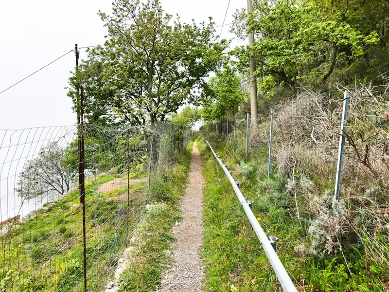
The Monte Falterona Trail is a circular route that begins and ends near Rifugio Casanova, a mountain lodge that serves as a convenient starting point and a place to refuel. The path winds its way through dense, ancient forests, predominantly beech and fir, which provide a cool and shaded environment even during warmer months. As the trail ascends, the landscape opens up, offering increasingly spectacular panoramic views of the surrounding Tuscan and Romagnolo Apennines. The highlight of the hike is reaching the summit of Monte Falterona (1,654 m), a place of serene beauty and historical resonance.
The ascent is steady, with some steeper sections that contribute to its moderate difficulty rating. Hikers will encounter a rich variety of plant life, including ferns, mosses, and a diverse array of wildflowers in spring and summer. Birdsong is a constant companion, and with a bit of luck and quiet observation, one might spot deer or other forest dwellers. The trail is well-marked, making navigation straightforward for most walkers.
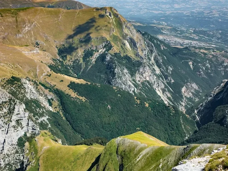
The summit of Monte Falterona offers a breathtaking 360-degree vista. On a clear day, one can see as far as the Adriatic Sea to the east and the rolling hills of Tuscany to the west. The area around the summit is also historically significant, with evidence of ancient settlements and religious sites. The descent follows a slightly different path, often incorporating sections that offer new perspectives on the valleys and forests below, ensuring the return journey is as engaging as the ascent.
History and Cultural Context
The Monte Falterona region has a long and rich history, dating back to ancient Etruscan and Roman times. The area was a vital route for trade and communication between the Po Valley and the Tyrrhenian coast. The presence of ancient settlements and archaeological finds in the vicinity attests to its strategic importance throughout history.
More recently, the forests of Monte Falterona were a significant source of timber, particularly for the construction of ships and for charcoal production, which fuelled the ironworks of the region. The landscape bears the marks of this historical exploitation, with evidence of old logging trails and charcoal kilns still visible in some areas.
The summit of Monte Falterona itself is associated with ancient pagan rituals and later with Christian hermitage. The area was considered sacred by ancient peoples, and it is believed that religious ceremonies took place here. In the Middle Ages, hermitages were established in the vicinity, with figures like Saint Romuald (founder of the Camaldolese Order) having connections to the spiritual significance of these mountains. The nearby hermitage of Camaldoli, though not directly on this trail, is a testament to the enduring spiritual allure of the region.
The establishment of the Foreste Casentinesi, Monte Falterona, and Campigna National Park in 1993 has been crucial in preserving the natural and historical heritage of this area, ensuring that its ancient forests and cultural landscapes are protected for future generations to appreciate and explore.
Seasonal Highlights and Weather Reality
The Monte Falterona Trail is best enjoyed during the spring and autumn months. From May to October, the weather is generally favourable for hiking, with temperatures typically ranging from 15°C to 25°C. However, it's crucial to be aware of the microclimates in the mountains; temperatures can drop significantly at higher elevations, especially in the early morning and late evening.
Spring (May-June): This is a particularly beautiful time to hike. The forests come alive with vibrant green foliage, and a profusion of wildflowers carpets the meadows. The air is fresh, and the streams are full. Temperatures are mild, making for comfortable hiking conditions. However, occasional spring showers are possible, so carrying waterproofs is advisable.
Summer (July-August): While the trail is accessible, summer can bring higher temperatures, particularly in the lower sections. The dense forest canopy offers welcome shade, but the ascent can still be strenuous in the midday heat. It's advisable to start early in the morning to avoid the peak heat and to carry plenty of water. The higher altitudes on Monte Falterona remain cooler than the surrounding valleys.
Autumn (September-October): Autumn offers a spectacular display of colours as the beech leaves turn shades of gold, red, and orange. The air is crisp, and the skies are often clear, providing excellent visibility from the summit. This season is ideal for photography and for enjoying the serene beauty of the mountains. The risk of rain increases as the season progresses.
Winter (November-April): While the trail is technically open, winter conditions can make hiking challenging and potentially dangerous. Snowfall is common at higher elevations, and the trail can be covered in ice and snow, requiring specialised winter hiking gear and experience. The Rifugio Casanova may have reduced operating hours or be closed during the winter months. For most recreational hikers, winter is not the recommended season for this trail.
Recommended Itinerary
Monte Falterona Day Walk Itinerary
Early Morning (Approx. 8:00 AM): Arrival and Preparation
- Arrive at Rifugio Casanova (GPS: 43.8463, 11.7027).
- Park your vehicle in the designated area.
- Use restroom facilities and prepare your backpack.
- Check trail conditions and weather forecast if possible.
- Have a quick coffee or light breakfast at the rifugio if desired.
Morning (Approx. 8:30 AM - 12:30 PM): Ascent through the Forest
- Begin the hike from the vicinity of Rifugio Casanova, following the well-marked trail (often indicated by red and white blazes or specific trail markers for Monte Falterona).
- The initial section of the trail leads into the dense beech and fir forests.
- Enjoy the cool, shaded environment and the sounds of nature.
- The path gradually ascends, with some steeper sections to build your fitness.
- Pass through areas with rich undergrowth, including ferns and mosses.
- Keep an eye out for wildlife and diverse plant species.
- The trail may pass by ancient trees and natural springs.
- As you gain elevation, the forest may begin to thin slightly, offering glimpses of the surrounding landscape.
Midday (Approx. 12:30 PM - 1:30 PM): Summit of Monte Falterona
- Reach the summit of Monte Falterona (1,654 m).
- Take time to admire the panoramic 360-degree views of the Apennine Mountains, Tuscany, and potentially the Adriatic Sea.
- Locate the summit marker or cross.
- Enjoy your packed lunch and rest, soaking in the expansive scenery.
- This is an excellent spot for photography.
- Note any historical markers or points of interest at the summit.
Afternoon (Approx. 1:30 PM - 4:00 PM): Descent and Return
- Begin the descent from Monte Falterona.
- The descent route may differ slightly from the ascent, offering new perspectives.
- Continue to follow the marked trail markers.
- The path will lead you back through the forests.
- Be mindful of your footing on the descent, especially on steeper or uneven sections.
- The forest environment will become more prominent again as you lose elevation.
- Pass by any notable landmarks or viewpoints encountered on the way up.
- The trail will eventually lead you back towards the vicinity of Rifugio Casanova.
Late Afternoon (Approx. 4:00 PM onwards): Completion and Refreshments
- Arrive back at Rifugio Casanova.
- You can enjoy a well-deserved meal or drink at the rifugio to celebrate the completion of your hike.
- Reflect on the day's journey and the beautiful scenery you have experienced.
- Begin your journey back to Florence or your next destination.
Important Notes:
- This is a moderate day hike; ensure you have adequate fitness.
- Carry sufficient water (at least 1.5-2 litres per person) as water sources on the trail may be unreliable or require treatment.
- Wear sturdy hiking boots with good ankle support.
- Pack layers of clothing, including a waterproof jacket, as mountain weather can change quickly.
- Bring a packed lunch and snacks.
- A map and compass or GPS device are recommended, although the trail is generally well-marked.
- Inform someone of your hiking plans and expected return time.
Planning and Bookings
Book Your Trip
Everything you need to plan your journey
Accommodation
Find places to stay near Florence
Flights
Search flights to Florence
Essential Preparation
The Monte Falterona Trail is a day hike, meaning no overnight accommodation is required. The primary logistical consideration is reaching the trailhead, which is best done by car. From Florence, the drive to Rifugio Casanova takes approximately 1.5 hours via the SS67 and then local roads. The roads leading to the rifugio are generally well-maintained, though they can be narrow and winding in places. Parking is available at Rifugio Casanova. For those without a car, public transport options involve taking a train from Florence to Stia, followed by a local bus or taxi to the rifugio. It is advisable to check bus schedules in advance, as they can be infrequent. Ensure you have a reliable navigation method, such as a GPS device or a detailed map of the area, as mobile phone signal can be intermittent in the mountains.
Trail Accommodation
This is a day hike requiring no overnight accommodation.
Required Gear
- Hiking Boots: Sturdy, waterproof hiking boots with good ankle support are essential for navigating uneven terrain and providing stability on ascents and descents.
- Backpack: A comfortable daypack (20-30 litres) to carry essentials like water, food, extra clothing, and safety equipment.
- Waterproof Jacket: A lightweight, breathable waterproof jacket is crucial, as mountain weather can change rapidly, bringing rain or wind.
- Layers of Clothing: Advise wearing moisture-wicking base layers, an insulating mid-layer (fleece or down jacket), and the waterproof outer shell.
- Navigation Tools: A map of the Foreste Casentinesi National Park, a compass, and/or a GPS device or smartphone with offline maps downloaded.
- Head Torch: Essential in case of unexpected delays or if starting very early/finishing late. Ensure it has fresh batteries.
- First Aid Kit: A basic kit including plasters, antiseptic wipes, pain relievers, blister treatment, and any personal medications.
- Sun Protection: Sunscreen (SPF 30+), sunglasses, and a wide-brimmed hat or cap, as sun exposure can be intense, especially at higher altitudes.
What to Bring
- Food: A packed lunch, energy bars, and snacks to sustain you throughout the 5-6 hour hike.
- Water: At least 1.5 to 2 litres of water per person. While there may be streams, it's advisable to treat any water collected from natural sources or carry enough to last the entire hike.
- Toiletries: Hand sanitiser, biodegradable wet wipes, and any personal hygiene items.
- Insect Repellent: Particularly useful during warmer months to ward off biting insects.
- Trekking Poles (Optional): Can provide extra stability and reduce strain on knees, especially during the descent.
- Camera: To capture the stunning scenery and panoramic views from Monte Falterona.
- Small Binoculars (Optional): For wildlife spotting and appreciating distant landscapes.
- Cash: For potential purchases at Rifugio Casanova or for any unexpected needs.
Permits
The Monte Falterona Trail is located within the Foreste Casentinesi, Monte Falterona, and Campigna National Park. Generally, no specific permits are required for day hiking on established trails within the park, including the Monte Falterona summit trail. The park is managed by the Carabinieri Forestali (Forestry Police) and the National Park Authority, which focus on conservation and visitor safety.
However, it is always advisable to check for any local regulations or temporary restrictions that may be in place, especially during peak seasons or for specific events. Information can usually be found on the official website of the Foreste Casentinesi National Park or by contacting the park's visitor centres.
Key points regarding access:
- No Entry Fees: Access to the national park and its trails is typically free of charge for day hikers.
- Respect Park Rules: Visitors are expected to adhere to the park's rules, which include staying on marked trails, not disturbing wildlife, and not leaving any litter.
- Rifugio Casanova: While not a permit requirement, Rifugio Casanova offers services such as food, drinks, and sometimes accommodation. It's a good idea to check their opening hours and services in advance, especially if you plan to use them before or after your hike.
- Driving: If driving, be aware of any parking regulations at the trailhead.
For the most up-to-date information, it is recommended to consult the official Foreste Casentinesi National Park website or contact their information services prior to your visit.
Other Activities in the Area
The Foreste Casentinesi National Park and its surroundings offer a wealth of activities for visitors looking to extend their stay or explore beyond the Monte Falterona hike:
- Visit the Hermitage of Camaldoli: A short drive from the Monte Falterona area, this historic monastery founded by Saint Romuald is a place of profound peace and spiritual significance. Visitors can explore the monastery, the ancient church, and the surrounding grounds.
- Explore the town of Stia: This charming Tuscan town is known for its historical textile production, particularly wool. Visit the Museo della Lana (Wool Museum) to learn about its industrial heritage. Stia also offers local shops, restaurants, and a picturesque central piazza.
- Hiking in the National Park: The Foreste Casentinesi National Park boasts an extensive network of trails catering to various fitness levels. Other popular routes include walks to the Lago degli Idoli (Lake of Idols), a significant archaeological site, and trails through the ancient forests of Campigna.
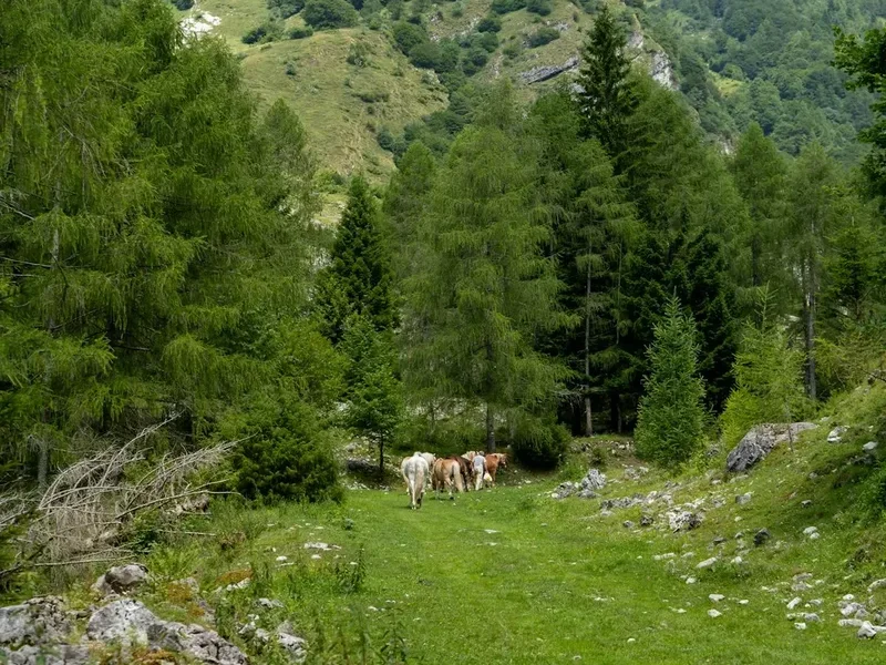
- Wildlife Watching: The park is a haven for diverse wildlife. With patience and quiet observation, you might spot deer, wild boar, foxes, and a variety of bird species, including birds of prey.
- Cycling and Mountain Biking: Numerous routes are available for cyclists, ranging from scenic road rides through the Tuscan countryside to challenging mountain bike trails within the park.
- Gastronomic Experiences: Tuscany is renowned for its cuisine. Enjoy local specialities such as wild boar dishes, handmade pasta, local cheeses, and excellent wines in the trattorias and restaurants of Stia and surrounding villages.
- Visit Poppi Castle: A magnificent medieval castle located in the nearby town of Poppi, offering stunning views and a glimpse into the region's feudal past.
Safety and Conditions
Trail Conditions: The Monte Falterona Trail is generally well-maintained and marked. However, conditions can vary depending on the season and recent weather. After heavy rain, sections of the trail may become muddy or slippery. In autumn, fallen leaves can obscure the path. Always wear appropriate footwear.
Weather: Mountain weather is unpredictable. Be prepared for rapid changes. Check the weather forecast before you set out and be aware that conditions at the summit can be significantly different from those at the trailhead. Hypothermia is a risk even in milder seasons if you get wet and cold, especially with wind chill at higher elevations.
Navigation: While the trail is marked, it is always wise to carry a map and compass or a GPS device. Mobile phone reception can be unreliable in the mountainous terrain, so do not solely rely on your phone for navigation or emergencies.
Wildlife: The park is home to various wildlife, including wild boar and deer. While encounters are usually peaceful, it's best to maintain a safe distance and avoid feeding any animals. Be aware of your surroundings, especially in dense forest areas.
Water: Carry sufficient water for the duration of your hike. Natural water sources should be treated before consumption to avoid waterborne illnesses.
Emergency Contacts: In case of an emergency, dial 112 (the European emergency number). It is also advisable to inform someone of your hiking plans, including your intended route and expected return time.
Rifugio Casanova: The presence of Rifugio Casanova offers a point of contact and potential assistance in case of minor issues, and it's a good place to get local information on trail conditions or weather.
Side Trips and Points of Interest
Summit of Monte Falterona: The primary point of interest, offering unparalleled panoramic views. The summit area is relatively open, allowing for unobstructed vistas. There may be a summit marker, cross, or small cairn indicating the highest point.
Ancient Forests: The trail passes through extensive areas of ancient beech and fir forests. These woodlands are characterised by their mature trees, dense undergrowth of ferns and mosses, and a rich biodiversity. The atmosphere within these forests is often described as serene and primeval.
Rifugio Casanova: While the starting and ending point, the rifugio itself is a point of interest. It provides a connection to the mountain's history as a place of refuge and hospitality for travellers and hikers. It's a good place to learn about local lore and current conditions.
Archaeological Significance: While not directly on the main trail, the broader region around Monte Falterona has archaeological importance, with evidence of ancient settlements. Information about these sites might be available at local visitor centres or through interpretive signs if encountered on alternative routes.
Panoramic Viewpoints: Along the ascent and descent, there are numerous natural clearings and vantage points that offer stunning views of the surrounding valleys, rolling hills of Tuscany, and the distant Apennine peaks. These spots are ideal for short breaks and photography.
Leave No Trace
The Monte Falterona Trail, situated within the Foreste Casentinesi National Park, is a precious natural environment that requires careful stewardship. Adhering to Leave No Trace principles ensures that this beautiful landscape remains pristine for future visitors and for the health of its ecosystems.
Plan Ahead and Prepare: Research the trail, weather, and any park regulations before your visit. Pack appropriately for the conditions and carry sufficient food and water.
Travel and Camp on Durable Surfaces: Stick to marked trails to avoid damaging fragile vegetation. The forest floor, with its mosses and ferns, is particularly sensitive. Avoid creating new paths or shortcuts.
Dispose of Waste Properly: Pack out everything you pack in. This includes all food scraps, wrappers, and any other litter. Use designated bins if available, but be prepared to carry all waste back with you. Use toilet facilities where available, or dig catholes at least 60 metres away from water sources, trails, and campsites.
Leave What You Find: Do not remove any natural objects, such as rocks, plants, or flowers. Take only photographs and memories.
Minimise Campfire Impacts: Campfires are generally not permitted on day hikes and should be avoided. If camping is permitted in designated areas (not applicable for this day hike), use established fire rings and ensure fires are completely extinguished.
Respect Wildlife: Observe wildlife from a distance. Never feed animals, as this can disrupt their natural behaviours and diets. Store food securely to prevent attracting animals.
Be Considerate of Other Visitors: Keep noise levels down, yield to other hikers on narrow trails, and maintain a respectful attitude towards fellow visitors and the natural environment.
By following these principles, you contribute to the preservation of the Monte Falterona's natural beauty and ecological integrity.