Montana Palentina Trail
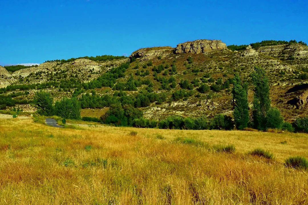
The Montana Palentina Trail is a captivating multi-day walk traversing the rugged and historically rich landscapes of the Palencia province in northern Spain. This route offers a profound immersion into the Picos de Europa National Park's eastern reaches, a region characterised by dramatic limestone peaks, verdant valleys, and ancient shepherd paths. The trail winds through a mosaic of ecosystems, from high alpine meadows dotted with wildflowers to dense oak and beech forests, offering a diverse and rewarding trekking experience. It connects remote villages, showcasing traditional Asturian and Leonese culture, and provides access to breathtaking viewpoints overlooking vast mountain ranges and deep gorges. This trail is an ideal choice for those seeking a challenging yet accessible adventure in a less-trodden corner of Spain, combining natural beauty with a deep sense of history and local heritage.
- Distance: 75.0 km
- Duration: 4–5 days
- Season: June to September
- Huts/Accommodation: Refugios, rural guesthouses, and small hotels
- Highest point: Approximately 2,200 m (variable depending on exact route and optional ascents)
- Daily walkers: Variable, generally low numbers outside peak season
- Direction: Typically a circular or point-to-point route, adaptable based on starting point
Overview
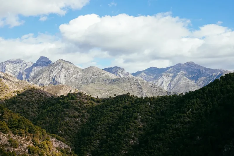
The Montana Palentina Trail is a journey through a landscape sculpted by millennia of geological forces and human endeavour. It is a route that rewards the intrepid with spectacular vistas and a genuine connection to the wild heart of the Cantabrian Mountains. The trail's moderate difficulty is balanced by significant elevation changes, demanding a good level of fitness and preparedness. Each day unfolds a new panorama, from the stark beauty of high-altitude scree slopes and limestone massifs to the serene tranquility of shaded forests and the gentle flow of mountain streams.
The trail's character is defined by its remoteness and the raw, untamed beauty of the Picos de Europa. Walkers will encounter a rich biodiversity, including diverse birdlife, chamois, and potentially even Iberian wolves or brown bears in the more secluded areas. The geological formations are a highlight, with vast karst landscapes, deep canyons like the impressive Cares Gorge (though the main trail often skirts its edges or uses sections of its access paths), and towering limestone peaks that dominate the skyline. The air is crisp and clean, carrying the scent of pine and wild herbs, a stark contrast to the urban environments many walkers leave behind.
Culturally, the trail passes through villages that have preserved their traditional architecture and way of life. These settlements, often perched precariously on hillsides or nestled in valleys, offer a glimpse into the resilience and resourcefulness of mountain communities. Local gastronomy, featuring hearty stews, cured meats, local cheeses, and robust wines, provides a welcome and delicious respite after a day's walking. The Montana Palentina Trail is more than just a physical challenge; it is an exploration of a unique natural and cultural heritage, offering an authentic Spanish mountain experience.
History and Cultural Context
The landscapes traversed by the Montana Palentina Trail have been shaped by human activity for millennia. Archaeological evidence suggests human presence in the Picos de Europa region dating back to the Paleolithic era, with numerous caves and rock shelters bearing witness to early human settlements. Later, the Romans exploited the region's mineral wealth, particularly iron ore, and established rudimentary roads that often followed natural contours, some of which form the basis of modern trails.
During the medieval period, the region played a significant role in the Reconquista, with mountain passes serving as strategic defensive points. Monasteries and hermitages were established in remote valleys, seeking solitude and spiritual refuge, and their ruins or surviving structures can still be found along some routes. The development of transhumance, the seasonal movement of livestock between summer pastures in the mountains and wintering grounds in lower valleys, profoundly shaped the landscape and the culture of the region. Ancient shepherd's paths, known as 'cañadas' or 'veredas', crisscross the mountains, and the Montana Palentina Trail often follows these historic routes, connecting grazing lands and remote villages.
The 20th century saw a decline in traditional mountain life as younger generations moved to urban centres. However, in recent decades, there has been a resurgence of interest in rural tourism and the preservation of cultural heritage. The establishment of the Picos de Europa National Park in 1918 (and later expanded) was a crucial step in protecting this unique environment from unchecked development. The Montana Palentina Trail, by guiding walkers through these historic landscapes, helps to keep alive the memory of the people who have lived, worked, and traversed these mountains for centuries, from ancient hunters and Roman miners to medieval monks and modern-day shepherds.
Seasonal Highlights and Weather Reality
The Montana Palentina Trail is best experienced during the late spring, summer, and early autumn months. Each season offers a distinct character and set of challenges.
Spring (May to June): This is a time of renewal. Wildflowers carpet the alpine meadows, creating vibrant displays of colour. Rivers and streams are often at their fullest due to snowmelt, and the air is fresh and invigorating. However, higher passes may still hold snow, particularly in early May, and unpredictable weather, including late frosts and thunderstorms, is common. Temperatures can range from cool in the valleys to chilly at higher altitudes.
Summer (July to August): This is the most popular time for hiking, offering the most stable weather conditions and long daylight hours. The higher mountain pastures are at their most accessible, and the scenery is at its most dramatic under clear blue skies. However, this is also the peak season for heat, especially in the lower valleys, and sandflies can be present. Thunderstorms can still occur, often developing rapidly in the afternoons.
Autumn (September to October): Autumn brings a spectacular transformation of the landscape as the deciduous forests turn to shades of gold, red, and orange. The air is crisp, and the light is often soft and beautiful, making it ideal for photography. The crowds thin out, offering a more tranquil experience. However, temperatures begin to drop, and snow can fall on higher elevations from mid-October onwards, potentially making some sections impassable without winter gear.
Winter (November to April): The Montana Palentina Trail is generally not recommended for hiking during winter due to heavy snowfall, ice, and extreme cold. Higher sections can be buried under metres of snow, and many refuges and services may be closed. This season is for experienced winter mountaineers only, requiring specialised equipment and knowledge.
Recommended Itinerary
4-Day Montana Palentina Trail Itinerary
Day 1: Velilla del Río Carrión to Refugio Pío Trueba (or nearby accommodation)
- Distance: 18 km
- Elevation gain: 1,000 m
- Time: 6–7 hours
- Start in Velilla del Río Carrión, a traditional mountain village.
- Follow well-marked paths ascending through oak and beech forests.
- The trail gradually steepens as it enters the higher alpine zone.
- Pass through meadows with potential for wildflower sightings in spring/early summer.
- Reach the vicinity of Refugio Pío Trueba (or alternative accommodation in the area), offering stunning views of the surrounding peaks.
- This day focuses on gaining altitude and acclimatising to the mountain environment.
Day 2: Refugio Pío Trueba to Posada de Valdeón (via high passes)
- Distance: 20 km
- Elevation gain: 1,200 m
- Elevation loss: 1,000 m
- Time: 7–8 hours
- A challenging day involving crossing high mountain passes.
- Ascend to a significant pass, offering panoramic views of the Picos de Europa.
- Descend into a remote valley, potentially passing through small hamlets or shepherd settlements.
- The route may involve sections of scree and rocky terrain.
- Continue the descent towards the picturesque town of Posada de Valdeón, a gateway to the Picos.
- This day is physically demanding but offers some of the most spectacular mountain scenery.
Day 3: Posada de Valdeón to Caín de Valdeón (or nearby)
- Distance: 15 km
- Elevation gain: 400 m
- Elevation loss: 600 m
- Time: 4–5 hours
- A more moderate day, often featuring a famous gorge walk.
- Descend from Posada de Valdeón towards the dramatic Cares Gorge.
- Walk along the well-maintained path carved into the gorge walls, with sheer drops and impressive rock formations.
- Experience the power of the Cares River far below.
- Arrive in the small village of Caín de Valdeón, situated within the gorge itself.
- This section is iconic and offers a unique perspective on the mountain landscape.
Day 4: Caín de Valdeón to Potes (or return to Velilla del Río Carrión)
- Distance: 22 km (to Potes) or 18 km (back to Velilla)
- Elevation gain: 800 m (to Potes) or 1,000 m (back to Velilla)
- Elevation loss: 700 m (to Potes) or 1,000 m (back to Velilla)
- Time: 6–7 hours (to Potes) or 6–7 hours (back to Velilla)
- Option 1: Continue towards the charming town of Potes, a larger hub with more amenities. This route may involve further ascents and descents through varied terrain.
- Option 2: Retrace steps or take an alternative route back towards Velilla del Río Carrión, completing a circular journey. This option offers a different perspective on the landscape.
- The final day provides a sense of accomplishment as you complete the trek, with opportunities for reflection on the journey.
Important Notes:
- This itinerary is a suggestion and can be adapted based on accommodation availability and personal preference.
- Accommodation options include mountain refuges (refugios), rural guesthouses (casas rurales), and small hotels in villages. Booking in advance is highly recommended, especially during peak season.
- Water sources can be scarce in some sections; carry sufficient water or a reliable purification method.
- Weather can change rapidly in the mountains; always be prepared for rain, wind, and temperature fluctuations.
- Navigation can be challenging in certain areas; a map, compass, and GPS device are essential.
Planning and Bookings
Book Your Trip
Everything you need to plan your journey
Accommodation
Find places to stay near Palencia
Flights
Search flights to Palencia
Essential Preparation
The Montana Palentina Trail requires careful planning, particularly regarding accommodation and logistics. Given its location in a national park, services can be sparse, and booking ahead is crucial. The closest major city with an airport is Valladolid (VLL), approximately a 2-hour drive away. From Valladolid, you can take a train or bus to Palencia, the provincial capital. From Palencia, local buses or taxis can take you to the trailhead villages such as Velilla del Río Carrión or Posada de Valdeón. Driving is often the most convenient option for accessing trailheads, with parking available in most villages, though it can be limited in smaller hamlets.
Fitness is a key consideration. The trail involves significant elevation gain and loss, often over rocky and uneven terrain. A good level of cardiovascular fitness and leg strength is essential. Familiarity with using a map and compass, or a GPS device, is also highly recommended, as some sections may be less clearly marked than popular long-distance trails.
Trail Accommodation
Accommodation along the Montana Palentina Trail varies, offering a mix of traditional mountain refuges and village-based lodgings.
- Refugios (Mountain Huts): These are basic shelters, often located in remote areas, providing dormitory-style sleeping arrangements. Facilities typically include bunk beds with mattresses, a communal dining area, and sometimes a simple kitchen. They may offer meals (breakfast, dinner) for an additional cost. Booking is essential, especially during the summer months. Examples include Refugio Pío Trueba.
- Casas Rurales (Rural Guesthouses): Found in villages along the route, these offer a more comfortable and private experience, often in charming, traditional stone houses. They provide private rooms and usually include breakfast.
- Small Hotels: Larger villages like Posada de Valdeón and Potes have small hotels offering standard amenities.
- Campsites: While wild camping is generally discouraged or prohibited within national parks, designated campsites may be available in some areas, particularly near larger towns.
Booking Requirements: It is strongly advised to book all accommodation well in advance, particularly for refuges and during the peak hiking season (July-August). Many refuges operate on a half-board basis (including dinner and breakfast), which simplifies logistics for trekkers.
Facilities Provided: Bunk beds, mattresses, communal areas, and sometimes basic kitchen facilities. Meals may be available at refuges and hotels.
What's NOT Provided: Sleeping bags (required for refuges), cooking equipment (unless specified), toiletries, and personal items. Water is usually available from streams or taps, but purification is recommended.
Seasonal Availability: Refuges are typically open from late May/June to mid-October. Village accommodation is available year-round, but services may be reduced outside the main season.
Costs: Refuges can range from €25-€40 per night for a bunk, with meals extra. Casas rurales and hotels vary widely, from €40-€80+ per night for a double room.
Required Gear
- Sturdy hiking boots: Waterproof, with good ankle support and a well-worn sole.
- Waterproof and windproof jacket: Essential for protection against sudden mountain weather changes.
- Waterproof overtrousers: To keep dry during rain showers.
- Warm layers: Fleece or down jacket, thermal base layers (merino wool or synthetic).
- Hiking trousers: Quick-drying and comfortable.
- Backpack: 30-45 litre capacity, with a rain cover.
- Sleeping bag: A 3-season bag is recommended for refuges.
- Navigation tools: Detailed topographic map of the area, compass, and a GPS device or smartphone with offline maps.
- Head torch: With spare batteries, for use in refuges or early/late starts.
- First-aid kit: Including blister treatment, pain relievers, antiseptic wipes, bandages, and any personal medications.
- Sun protection: High SPF sunscreen, sunglasses, and a wide-brimmed hat.
- Trekking poles: Highly recommended for steep ascents and descents, and for stability on uneven terrain.
What to Bring
- Food and snacks: High-energy snacks like nuts, dried fruit, energy bars. Consider packed lunches for days when you won't have access to village services.
- Water bottles or hydration reservoir: Capacity of at least 2 litres per person.
- Water purification method: Filter or purification tablets, as stream water quality can vary.
- Toiletries: Biodegradable soap, toothbrush, toothpaste, small towel, hand sanitiser.
- Personal items: Camera, power bank for electronics, book or journal.
- Cash: Many refuges and small establishments may not accept credit cards.
- Insect repellent: Especially important during summer months.
- Duct tape and cord: Useful for repairs.
- Whistle: For emergency signalling.
Permits
The Montana Palentina Trail, being primarily within the Picos de Europa National Park, does not typically require specific permits for general hiking. However, regulations can change, and it is always advisable to check the official Picos de Europa National Park website or local tourist information offices for the most up-to-date information regarding access, any potential restrictions, or specific requirements for certain areas or activities.
National Park Entry: Entry into the Picos de Europa National Park itself is generally free for hikers. However, some specific areas or attractions within the park might have associated fees or require advance booking, particularly those involving organised tours or access to highly sensitive ecological zones. For instance, access to certain viewpoints or specific routes might be managed during peak times.
Accommodation Bookings: While no permit is needed to walk the trail, booking accommodation in advance is essential. Refuges and rural guesthouses operate on a reservation system, and spaces can fill up quickly, especially during the summer months and weekends. It is recommended to book your lodging several weeks, or even months, in advance.
Vehicle Access: If you are driving to the trailhead, be aware that access roads to some villages or starting points might have restrictions, especially during peak season, to manage traffic and preserve the environment. Parking availability can also be limited in smaller villages.
Guides and Tours: If you opt for a guided trek, the tour operator will usually handle any necessary permits or bookings for accommodation and activities as part of their package.
Always verify: Before your trip, consult the official website of the Picos de Europa National Park (Parque Nacional de los Picos de Europa) or the regional tourism board for the most current information on regulations, access, and any required bookings.
Other Activities in the Area
The Picos de Europa region offers a wealth of activities beyond hiking, allowing for a richer exploration of the area:
- Cares Gorge Walk (Ruta del Cares): While often incorporated into the trail, this iconic walk can be done as a separate day trip, offering spectacular views of the gorge and the river.
- Cable Car to Fuente Dé: Take a breathtaking cable car ride from the village of Fuente Dé up to a high plateau, offering stunning panoramic views and access to further walking routes.
- Village Exploration: Visit charming mountain villages such as Potes, known for its medieval architecture and lively atmosphere, or Bulnes, a remote village accessible only by foot or funicular railway.
- Rock Climbing and Via Ferrata: The Picos de Europa are a mecca for climbers, with numerous routes for all skill levels. Via ferrata routes offer a thrilling way to experience the vertical landscape.
- Stargazing: Due to its remote location and minimal light pollution, the Picos de Europa offer exceptional opportunities for stargazing.
- Local Gastronomy: Indulge in the regional cuisine, which includes hearty stews, game dishes, local cheeses (like Cabrales), and excellent Asturian cider.
- Wildlife Watching: The park is home to diverse wildlife, including chamois, eagles, vultures, and potentially even bears and wolves. Guided wildlife tours can enhance your chances of spotting these animals.
Safety and Conditions
Weather: Mountain weather in the Picos de Europa can be highly unpredictable and change rapidly. Be prepared for sun, rain, wind, and even snow at higher altitudes, regardless of the season. Always check the weather forecast before setting out each day and be ready to adapt your plans.
Navigation: While many sections of the Montana Palentina Trail are well-marked, some parts can be remote and challenging to navigate, especially in poor visibility. Carry a detailed map, compass, and GPS device, and know how to use them. Inform someone of your planned route and expected return time.
Terrain: The trail involves significant elevation changes and can include steep ascents, descents, rocky paths, scree slopes, and potentially exposed sections. Sturdy hiking boots with good grip are essential. Trekking poles can provide stability and reduce strain on your knees.
Water: Water sources can be scarce in some high-altitude areas. Carry sufficient water (at least 2 litres per person) and consider using a water filter or purification tablets, especially when drinking from streams.
Altitude: While not extremely high, some sections of the trail reach significant altitudes. Be aware of the symptoms of altitude sickness and acclimatise gradually if coming from sea level.
Wildlife: The Picos de Europa are home to various wildlife, including chamois, birds of prey, and potentially larger mammals like bears and wolves. Maintain a safe distance, do not feed any animals, and store food securely.
Emergency: In case of emergency, know the local emergency number (112 in Spain). Mobile phone reception can be unreliable in mountainous areas, so consider carrying a personal locator beacon (PLB) or satellite messenger for remote sections.
Refuge Safety: Follow the rules and guidelines of any refuges you stay in. Ensure your sleeping bag is clean and that you respect quiet hours.
Side Trips and Points of Interest
Fuente Dé Cable Car: A spectacular 750-metre vertical ascent via cable car from the valley floor to a high plateau. The views from the top are breathtaking, and it serves as a starting point for numerous high-altitude walks and climbs within the Picos.
Bulnes Village: This remote village, once accessible only by a challenging hike or mule track, is now also reachable by a funicular railway. It offers a unique glimpse into a traditional mountain community and is a base for exploring the heart of the Picos.
Cares Gorge (Ruta del Cares): While often part of the main trail, walking the full length of this iconic gorge, carved by the Cares River, is a highlight. The path is hewn into the cliff face, offering dramatic views and a sense of scale.
Lagos de Covadonga: Although slightly outside the immediate trail area, these glacial lakes are a significant natural attraction and a popular destination for day trips from the Picos region. They offer beautiful walking opportunities and stunning scenery.
Potes Town: A charming medieval town at the confluence of four valleys, Potes is a vibrant hub with historic architecture, a lively market, and excellent restaurants. It's a great place to rest and resupply.
Mirador del Fitu: A viewpoint offering panoramic vistas of the Picos de Europa mountains on one side and the Cantabrian Sea on the other, providing a stunning contrast of landscapes.
Leave No Trace
The Picos de Europa National Park is a fragile ecosystem that requires careful stewardship. Adhering to Leave No Trace principles is paramount to preserving its natural beauty and ecological integrity for future generations.
- Plan Ahead and Prepare: Research your route, understand the terrain and weather, and book accommodation in advance. Pack appropriately for all conditions.
- Travel and Camp on Durable Surfaces: Stick to marked trails to avoid damaging vegetation. If camping is permitted in designated areas, use established sites.
- Dispose of Waste Properly: Pack out everything you pack in, including all food scraps, wrappers, and toilet paper. Use designated toilets where available. If no facilities exist, dig a cathole at least 60 metres away from water sources, trails, and campsites.
- Leave What You Find: Do not remove any natural objects, such as rocks, plants, or flowers. Respect historical and cultural sites.
- Minimize Campfire Impacts: Campfires are generally prohibited in national parks. If permitted in specific areas, use existing fire rings and ensure fires are completely extinguished.
- Respect Wildlife: Observe wildlife from a distance. Never feed animals, as it can disrupt their natural behaviours and diets. Store food securely to prevent attracting animals.
- Be Considerate of Other Visitors: Keep noise levels down, yield to other hikers, and maintain a respectful attitude towards the natural environment and local culture.
By following these principles, you contribute to the conservation of this magnificent mountain landscape.