Moldoveanu Peak Trail - Romania's Highest Summit
The Moldoveanu Peak Trail is a challenging mountain trek in Romania's Făgăraș Mountains, leading to the country's highest point, Moldoveanu Peak, at 2,505 metres. This route offers a true alpine experience, traversing rugged terrain, dramatic ridgelines, and breathtaking panoramic views. It is a demanding but immensely rewarding journey for experienced hikers seeking to conquer the Roof of Romania. The trail is typically undertaken over two days, allowing for acclimatisation and a more thorough appreciation of the surrounding Carpathian landscape. Access is via the scenic Transfăgărășan Highway, which itself is an adventure, though it is only open seasonally.
- Distance: 25.0 km (round trip)
- Elevation Gain: 1,500 m
- Duration: 1-2 days
- Difficulty: Challenging
- Best Time: June to September
- Closest City: Brașov
- Trailhead Access: Drive to Valea Rea (approx. 3-4 hours from Brașov). Road conditions vary, last section unpaved, 4x4 recommended. Parking available. Consider taxi or tour from Brașov.
Overview
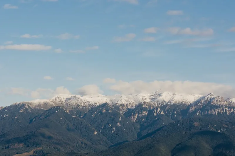
The Moldoveanu Peak Trail is a quintessential Romanian mountain adventure, a journey that tests endurance and rewards with unparalleled vistas. Starting from the remote Valea Rea valley, the trail ascends steadily through mixed forests before breaking out onto the alpine meadows and rocky ridges characteristic of the Făgăraș range. The Făgăraș Mountains, often referred to as the "Transylvanian Alps," are the highest range in Romania, and Moldoveanu Peak stands as their undisputed monarch.
The ascent is relentless, with significant elevation gain packed into a relatively short distance. Hikers will encounter varied terrain, from well-trodden paths to scree slopes and exposed ridgelines. The route often follows marked trails, but navigation can be challenging in poor visibility, making a map, compass, and GPS device essential. The summit itself is a relatively broad, rocky plateau, offering a sense of accomplishment and a commanding 360-degree view of the surrounding Carpathian peaks, including neighbouring Vârful Negoiu, Romania's second-highest summit.
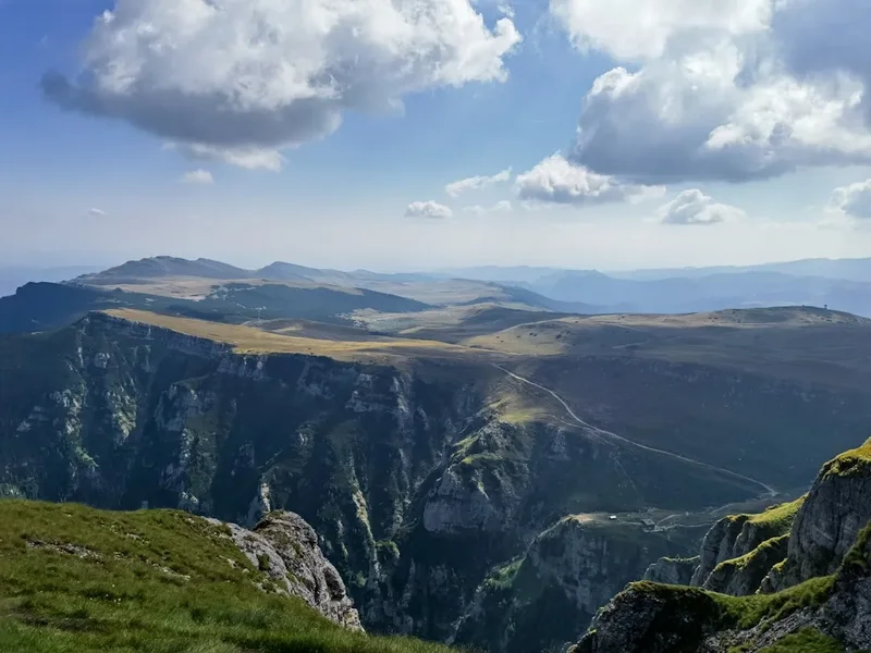
The Făgăraș Mountains are known for their wild beauty and relative remoteness. While popular with local hikers and mountaineers, they are less frequented by international tourists compared to other European ranges. This offers a unique opportunity to experience a more authentic and less commercialised mountain environment. The flora and fauna are rich, with opportunities to spot chamois, marmots, and a variety of alpine flowers during the summer months. The weather can be unpredictable, with rapid changes from sunshine to storms, necessitating careful preparation and flexibility.
History and Cultural Context
The Făgăraș Mountains have a long history of human interaction, primarily driven by pastoralism and resource extraction. For centuries, shepherds have guided their flocks through these high pastures during the summer months, a tradition that has shaped the landscape and local culture. The trails themselves often follow ancient routes used by these shepherds and, in earlier times, by inhabitants of the surrounding regions for trade and defence.
The Făgăraș range also played a role in Romania's more recent history. During the communist era, the Transfăgărășan Highway was constructed through the mountains, a monumental engineering feat that was as much a symbol of national pride as a strategic military road. While the highway provides access to the foothills of the Făgăraș, the higher peaks and trails remain largely wild and untamed.
The specific routes to Moldoveanu Peak have been used by mountaineers and hikers for decades. While there isn't a single, definitive "discovery" narrative like some more famous trails, the ascent has been a goal for Romanian climbers and outdoor enthusiasts since the early 20th century. The establishment of national parks and protected areas in recent decades has aimed to preserve the natural beauty and ecological integrity of the Făgăraș Mountains, ensuring that these wild landscapes can be appreciated for generations to come.
Seasonal Highlights and Weather Reality
The hiking season for Moldoveanu Peak is relatively short, dictated by the harsh winter conditions that grip the Făgăraș Mountains for much of the year. The primary window for a safe and enjoyable trek is from June to September.
June: The early summer offers lush green landscapes and blooming wildflowers. Snow may still linger at higher elevations, particularly in shaded gullies and on north-facing slopes. Water sources are generally abundant. The Transfăgărășan Highway typically opens in late June, providing access.
July & August: These are the peak months for hiking. The weather is generally more stable, though thunderstorms are common in the afternoons. Wildflowers are at their most vibrant, and wildlife sightings are more frequent. Days are long, allowing for ample hiking time. This is also the busiest period for the trail.
September: Autumn brings crisp air, clear skies, and stunning autumnal colours to the lower slopes. The crowds thin out, offering a more serene experience. However, temperatures begin to drop, and the first snowfalls can occur towards the end of the month. The Transfăgărășan Highway usually closes in late October or early November.
October to May: This period is generally unsuitable for hiking Moldoveanu Peak due to heavy snow, ice, and extreme cold. The Transfăgărășan Highway is closed, and the trails become treacherous alpine routes requiring advanced winter mountaineering skills, equipment, and experience. Avalanches are a significant hazard.
Weather: Mountain weather in the Făgăraș is notoriously unpredictable. Even in summer, conditions can change rapidly. Expect sunshine, rain, fog, and strong winds, sometimes all within a single day. Afternoon thunderstorms are a frequent occurrence and can bring lightning, heavy rain, and hail. Hypothermia is a risk even in summer due to altitude and wind chill.
Recommended Itinerary
2-Day Moldoveanu Peak Itinerary
Day 1: Valea Rea Trailhead to Refugiul Căldarea Zânelor (or similar high camp)
- Distance: Approx. 10-12 km
- Elevation Gain: Approx. 800-1000 m
- Time: 5-7 hours
- Start at the Valea Rea trailhead, accessible via a rough track (4x4 recommended).
- The initial section follows the Valea Rea stream through dense forest.
- The trail gradually steepens, transitioning from forest to alpine meadows.
- Look for trail markers (typically red or yellow stripes).
- Aim to reach a suitable high camp location, such as near Refugiul Căldarea Zânelor (She-Goat's Caldera Refuge), which offers basic shelter and water sources.
- Set up camp and acclimatise to the altitude.
- Enjoy the remote wilderness and prepare for the summit push the following day.
- This day focuses on gaining significant elevation and positioning yourself for an early start to the summit.
Day 2: High Camp to Moldoveanu Peak and Return to Trailhead
- Distance: Approx. 13-15 km (round trip from camp)
- Elevation Gain: Approx. 500-700 m to summit, then descent
- Time: 7-10 hours (including summit time)
- Begin before sunrise for the best chance of clear weather and to avoid afternoon thunderstorms.
- The trail continues upwards, often becoming steeper and more exposed.
- Navigate towards the saddle between Moldoveanu Peak and Vârful Negoiu.
- The final ascent to Moldoveanu Peak is a rocky scramble.
- Reach the summit marker (2,505 m) and enjoy the panoramic views.
- Take photos and celebrate your achievement.
- Descend carefully back to your high camp.
- Pack up camp and continue the descent back to the Valea Rea trailhead.
- This is a long and demanding day, requiring good fitness and navigation skills.
Alternative 1-Day Itinerary (for very fit and experienced hikers):
- This is a highly strenuous option, only recommended for those with exceptional fitness, acclimatisation, and a very early start (pre-dawn).
- It involves a very early departure from the Valea Rea trailhead, a rapid ascent to the summit, and a swift descent.
- Requires perfect weather conditions and minimal stops.
- Not recommended for most hikers due to the high risk of exhaustion and being caught out by afternoon weather.
Important Notes:
- Trail markers can be infrequent or faded; a reliable map, compass, and GPS are essential.
- Water sources can be scarce at higher altitudes; carry sufficient water or a reliable purification method.
- The summit ridge is exposed; avoid hiking during thunderstorms or high winds.
- Accommodation: Basic refuges (shelters) exist, but camping is common. Ensure you are equipped for wild camping.
- Check weather forecasts meticulously before and during your hike.
Planning and Bookings
Book Your Trip
Everything you need to plan your journey
Accommodation
Find places to stay near Brașov
Flights
Search flights to Brașov
Essential Preparation
The Moldoveanu Peak Trail is a serious undertaking that requires thorough preparation. Given its remote location and challenging nature, it's crucial to be self-sufficient and well-informed. The closest major city is Brașov, which serves as a good base for final preparations, stocking up on supplies, and arranging transport. From Brașov, you'll need to drive towards the Transfăgărășan Highway and then access the Valea Rea valley. The final section of road to the trailhead is often unpaved and rough, making a 4x4 vehicle highly recommended. If you don't have one, consider hiring a local guide with appropriate transport or arranging a taxi service that can handle the terrain.
Fitness is paramount. This hike involves significant elevation gain and sustained effort over rugged terrain. Cardiovascular fitness, leg strength, and endurance are essential. Train by hiking with a weighted pack, focusing on uphill climbs and long distances. Familiarise yourself with map reading and navigation techniques, as trail markings can be inconsistent.
Trail Accommodation
This is a wild mountain hike, and formal accommodation is extremely limited. The primary options are:
Wild Camping: This is the most common form of accommodation for hikers undertaking the Moldoveanu Peak Trail. Designated campsites are not provided; hikers are expected to practice responsible wild camping. Choose a durable surface away from water sources and trails. Ensure you are equipped with a sturdy tent suitable for mountain conditions, a warm sleeping bag, and a sleeping mat.
Refuges/Shelters: There are a few basic mountain refuges or shelters in the Făgăraș Mountains, such as Refugiul Căldarea Zânelor. These are typically very rudimentary, offering basic protection from the elements but little in the way of comfort or facilities. They may have a simple sleeping platform and sometimes a basic stove or fireplace. Do not rely on these as guaranteed accommodation; they can be occupied or in disrepair. It is wise to carry camping gear even if you plan to use a refuge.
Huts/Lodges: There are no formal mountain huts or lodges directly on the Moldoveanu Peak Trail in the style found in the Alps or New Zealand. The nearest established accommodation would be in villages or towns at the base of the mountains, such as near the Transfăgărășan Highway, but these are not practical for overnight stays during the hike itself.
Booking Requirements: No bookings are required for wild camping or basic refuges. However, it is advisable to check the condition and accessibility of any known refuges before your trip through local hiking forums or clubs.
Facilities Provided: Basic shelters may offer a roof and walls. Water sources are typically natural streams, which should be treated.
What's NOT Provided: Food, cooking equipment, sleeping gear, toilets, electricity, heating, or any amenities. You must be entirely self-sufficient.
Seasonal Availability: Wild camping and refuges are available throughout the hiking season (June-September). However, access to the trailhead via the Transfăgărășan Highway is seasonal, typically opening in late June and closing in late October/early November.
Costs: Wild camping is free. Use of basic refuges is usually free or by voluntary donation.
Required Gear
- Sturdy, waterproof hiking boots with good ankle support.
- Waterproof and windproof jacket and trousers (Gore-Tex or similar).
- Warm layers: fleece jacket, thermal base layers (merino wool or synthetic).
- Insulated jacket (down or synthetic) for colder evenings or summit attempts.
- Warm hat (beanie) and gloves.
- Backpack (50-70 litres) with a rain cover.
- Sleeping bag rated for sub-zero temperatures (e.g., comfort rating of -5°C to 0°C).
- Sleeping mat for insulation and comfort.
- Tent suitable for mountain conditions (wind-resistant, waterproof).
- Head torch with spare batteries.
- First-aid kit including blister treatment, pain relievers, antiseptic wipes, bandages, and any personal medications.
- Navigation tools: detailed topographic map of the Făgăraș Mountains, compass, and a GPS device or smartphone with offline maps and a power bank.
- Sun protection: high SPF sunscreen, sunglasses, and a wide-brimmed hat.
- Insect repellent (especially for lower forest sections).
What to Bring
- Food for the duration of your hike (high-energy, lightweight meals and snacks). Plan for at least two days.
- Water bottles or hydration reservoir (minimum 2-3 litres capacity per person).
- Water purification method (filter, tablets, or UV steriliser).
- Cooking stove (gas or liquid fuel) and fuel.
- Cook pot, mug, bowl, and eating utensils.
- Lighter or waterproof matches.
- Toiletries: toothbrush, toothpaste, biodegradable soap, small towel, hand sanitiser.
- Toilet paper and a trowel for burying human waste (Leave No Trace principles).
- Emergency shelter (e.g., bivy bag or emergency blanket).
- Trekking poles (highly recommended for ascents and descents).
- Camera and spare batteries/power bank.
- Small repair kit (duct tape, cordage, needle and thread).
- Cash for potential local transport or small purchases.
Permits
For the Moldoveanu Peak Trail itself, no specific permits are typically required for independent hikers. The Făgăraș Mountains are largely within protected areas, but the trails are generally open access for recreational hiking. However, it is always advisable to check the latest regulations with local authorities or the Romanian Ministry of Environment before your trip, as rules can change.
National Park Fees: While there might not be an explicit "permit" to hike the trail, there may be entrance fees or regulations associated with the national park areas you traverse. These are usually minimal and collected at entry points or through local ranger stations if applicable. For the Făgăraș Mountains, which are part of the Făgăraș Nature Park and the larger Carpathian Mountains ecosystem, such fees are uncommon for simple hiking but can apply to organised tours or specific activities.
Camping Regulations: Wild camping is generally permitted in Romania, but it's essential to follow Leave No Trace principles. This means camping away from water sources, trails, and protected flora, and packing out all waste. Avoid making campfires unless in designated areas, which are rare in the high alpine zones.
Transfăgărășan Highway Access: The primary access route, the Transfăgărășan Highway (DN7C), is a national road. It is typically open from late June to late October/early November, depending on snow conditions. There are no specific permits required to drive on this highway, but it is a toll-free road. Be aware of its seasonal closure dates.
Guides and Organised Tours: If you book with a guided tour operator, they will typically handle any necessary permissions or fees as part of their service. It's worth confirming this with them.
Recommendation: Before your trip, consult the official website of the Făgăraș Nature Park (if available) or contact local tourist information centres in Brașov or nearby towns for the most up-to-date information on regulations, trail conditions, and any potential access requirements.
Other Activities in the Area
The Făgăraș Mountains and the surrounding region offer a wealth of activities for nature lovers and adventurers:
- Transfăgărășan Highway Drive: Even if you're not hiking, driving this spectacular mountain road is an experience in itself. It offers incredible viewpoints, access to glacial lakes like Bâlea Lake, and opportunities for short walks.
- Vârful Negoiu Hike: As Romania's second-highest peak, Vârful Negoiu (2,505 m) is another challenging and rewarding summit in the Făgăraș range. It can be combined with a Moldoveanu Peak trek or undertaken as a separate expedition.
- Bâlea Lake: A stunning glacial lake situated at a high altitude on the Transfăgărășan Highway. It's a popular spot for photos, and there are facilities like hotels and restaurants nearby.
- Peleș Castle and Sinaia: A day trip from Brașov can take you to the magnificent Peleș Castle, a former royal residence, and the charming mountain resort town of Sinaia.
- Brașov City Exploration: Spend time exploring the historic medieval city of Brașov, with its Black Church, Council Square, and the Tampa Mountain cable car offering panoramic views.
- Râșnov Fortress: A well-preserved medieval fortress located near Brașov, offering insights into Romania's defensive architecture.
- Bear Sanctuary Libearty (Zărnești): Visit the largest bear sanctuary in Europe, providing a safe haven for rescued brown bears.
- Hiking in Bucegi Mountains: Neighbouring the Făgăraș, the Bucegi Mountains offer different landscapes and hiking opportunities, including unique rock formations like the Sphinx and Babele.
Safety and Conditions
Pre-Trip Checks:
- Weather Forecast: Always check the mountain weather forecast for the Făgăraș Mountains immediately before and during your hike. Websites like Meteo Romania or specific mountain weather services are invaluable. Be prepared for rapid changes.
- Trail Conditions: Consult local hiking forums, guidebooks, or the Romanian Alpine Club for recent trail condition reports. Snow can linger into July on shaded slopes, and trails can be affected by landslides or erosion after heavy rain.
- Road Access: Verify the opening status of the Transfăgărășan Highway if you are using it for access.
- Emergency Contacts: Save the national emergency number (112) and any local mountain rescue service numbers to your phone.
On the Trail:
- Navigation: Trail markings can be inconsistent or absent in places. Carry a map, compass, and GPS device, and know how to use them. Do not rely solely on mobile phone apps, as signal is unreliable.
- Altitude Sickness: While not as high as some ranges, altitude sickness can still affect individuals. Ascend gradually, stay hydrated, and be aware of symptoms (headache, nausea, dizziness).
- Weather Changes: Be prepared for sudden storms, especially in the afternoons. If thunder and lightning are present, descend immediately to a lower elevation or seek shelter in a sturdy refuge (avoid exposed ridges and solitary trees).
- Hypothermia: Even in summer, temperatures at altitude can drop significantly, especially with wind and rain. Carry sufficient warm layers and waterproofs.
- Water Sources: While streams are generally available, always treat water from natural sources to avoid waterborne illnesses.
- Wildlife: The Făgăraș Mountains are home to brown bears. While encounters are rare and bears generally avoid humans, be aware of your surroundings, make noise while hiking, and store food securely. Do not approach or feed wildlife.
- Physical Exertion: This is a demanding hike. Pace yourself, take regular breaks, and do not push beyond your limits. Inform someone of your hiking plans and expected return time.
Travel Insurance: Ensure your travel insurance covers mountain hiking and potential emergency evacuation.
Side Trips and Points of Interest
Vârful Negoiu (2,505 m): The second-highest peak in Romania, Vârful Negoiu is often considered a more technically challenging and dramatic summit than Moldoveanu. The route to Negoiu involves scrambling and exposed sections, including the infamous "Black Gate" (Poarta Neagră), a narrow passage requiring careful navigation. It can be incorporated into a longer trek or undertaken as a separate challenging hike.
Căldarea Zânelor (She-Goat's Caldera): This is a beautiful glacial cirque and a common camping spot on the route to Moldoveanu Peak. It offers a sense of remoteness and stunning alpine scenery, often with small tarns and wildflowers in season.
Bâlea Lake (Lacul Bâlea): Accessible via the Transfăgărășan Highway, this large glacial lake is a popular tourist destination. It offers a stark contrast to the wilder hiking trails and provides amenities like restaurants and accommodation. The views from the lake are spectacular.
Transfăgărășan Highway Viewpoints: The highway itself is a point of interest, winding through dramatic mountain landscapes. Numerous viewpoints offer opportunities to stop, admire the scenery, and take photographs of the valleys and peaks.
Glacial Tarns: Scattered throughout the Făgăraș range are numerous small glacial lakes (tarns). These pristine bodies of water, often surrounded by rocky slopes, add to the wild beauty of the landscape and can be rewarding detours for photography.
Leave No Trace
The Făgăraș Mountains are a precious natural environment, and it is crucial for all visitors to adhere to Leave No Trace principles to preserve their beauty and ecological integrity.
Plan Ahead and Prepare: Research your route, understand the terrain, and be aware of weather conditions. Pack appropriate gear and food to minimise waste.
Travel and Camp on Durable Surfaces: Stick to established trails to avoid damaging fragile vegetation. When camping, choose established sites or durable surfaces like rock or gravel, at least 70 metres away from water sources.
Dispose of Waste Properly: Pack out everything you pack in, including all food scraps, wrappers, and toilet paper. Use designated toilets where available, or dig catholes at least 15-20 cm deep and 70 metres away from water, trails, and campsites. Pack out all toilet paper.
Leave What You Find: Do not remove natural objects like rocks, plants, or flowers. Respect cultural heritage sites.
Minimise Campfire Impacts: Campfires are generally discouraged in alpine environments due to their impact on vegetation and the risk of wildfires. If permitted and necessary, use established fire rings and keep fires small. Ensure fires are completely extinguished before leaving.
Respect Wildlife: Observe wildlife from a distance. Never feed animals, as this can disrupt their natural behaviours and diets, and can be harmful to their health. Store food securely to prevent attracting animals.
Be Considerate of Other Visitors: Keep noise levels down, especially in the early morning and late evening. Yield to others on the trail. Respect the solitude of the wilderness.