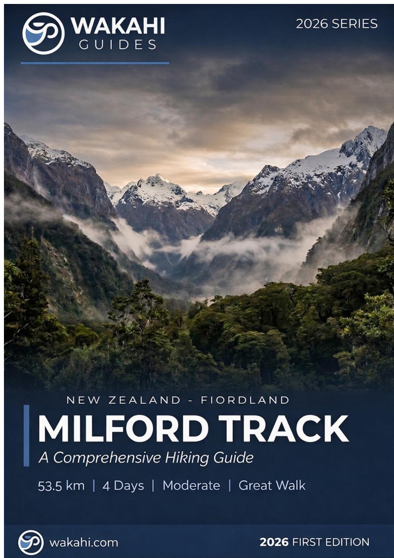
Milford Track - The Finest Walk in the World
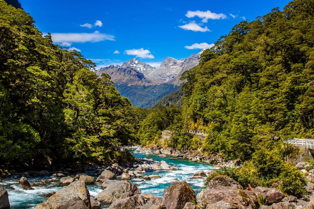
The Milford Track is New Zealand's premier alpine adventure—a 53.5 km four-day, three-night journey through the heart of Te Wāhipounamu South West New Zealand World Heritage Area. Running exclusively from the glacial waters of Lake Te Anau to the sheer granite walls of Piopiotahi/Milford Sound, this one-directional route weaves through ancient beech forests draped in emerald moss, alongside crystal-clear rivers, and over the dramatic alpine saddle of Ōmanui/MacKinnon Pass. Access is strictly by boat at both ends—an intentional design that preserves the profound sensation of stepping into a lost world where nature rules supreme, undisturbed by road access or commercialisation. This is a walking experience that demands respect, reward that surpasses expectations, and a journey that fundamentally changes how walkers understand wilderness.
- Distance: 53.5 km one-way
- Duration: 4 days / 3 nights
- Season: Late October–April (bookings required; outside this window, winter alpinism skills essential)
- Huts (mandatory booking during Great Walks season): Clinton, Mintaro, Dumpling
- Highest point: Ōmanui/MacKinnon Pass (1,154 m)
- Daily walkers (independent): Maximum 40 per day during booked season
- Direction: South to north only (one-directional; no loops or return options)
Overview
Famously dubbed "The Finest Walk in the World" by poet Blanche Baughan in an 1908 article published in The Spectator, the Milford Track has earned and sustained that reputation across more than a century. The route is a masterclass in landscape pacing: Day 1 begins with a deceptively gentle stroll through the glaciated Clinton Valley where silver beech trees arch overhead like a living cathedral, creating a false sense of ease. Day 2 gradually crescendos as elevation gain becomes perceptible—a perfect rhythm that builds fitness and acclimatisation without overwhelming tired legs. Day 3 transforms into raw mountain challenge with steep switchbacks climbing to MacKinnon Pass (500 m elevation gain over 5 km), followed by a demanding 800 m descent that tests knees and concentration in equal measure. Day 4 concludes with a long descent through the lush, fern-filled Arthur Valley where waterfalls plunge from every hanging valley in such profusion that you forget which are permanent and which temporary.
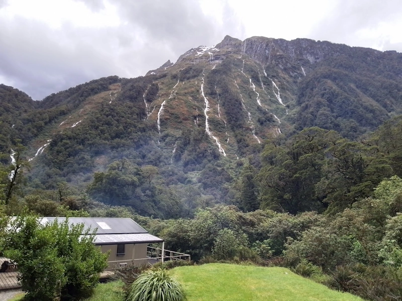
This is fundamentally a landscape defined by water. Fiordland receives up to 9,000 mm of annual rainfall (among New Zealand's wettest regions), and the Milford Track itself sees precipitation on approximately 182 days per year. In glorious sunshine—a genuine gift when it arrives—the views are vast, humbling, and the granite peaks tower impossibly high, their scale difficult to comprehend until you stand beneath them. But in the heavy rain that so frequently accompanies a Milford Track walk, the valley walls transform into a living tapestry of thousands of temporary waterfalls, a phenomenon many experienced walkers consider more spectacular and emotionally moving than any clear-day panorama. The waterfalls emerge from cliff faces where they don't exist in dry conditions; the valley seems to weep with life.
Strictly regulated access—limited to 40 independent walkers per day during the Great Walks season (late October to April)—ensures a rare gift in the modern hiking world: genuine solitude in pristine wilderness. You will encounter other groups at huts, but the track's width and the valley's immensity mean there are stretches where you walk in complete isolation. This four-day odyssey combines serious physical challenge with landscape beauty and cultural depth in a way few tracks on Earth can match.
Wakahi Guide
Detailed route notes, maps, logistics & tips for the Milford Track (PDF).
History and Cultural Context
Long before European surveyors arrived, Māori—particularly Ngāi Tahu—traveled these valleys as part of seasonal routes to transport pounamu (greenstone/jade) from the West Coast to coastal trading centres. These journeys were arduous, technically demanding passages through one of the world's most challenging climates. The land remains of profound cultural significance to Ngāi Tahu; it is ancestral territory steeped in whakapapa (genealogy) and spiritual connection.
The modern Milford Track as a hiking route began in 1888 when the Otago Survey Department commissioned Quintin MacKinnon—a Scottish settler and explorer—to find an overland passage from Lake Te Anau to Milford Sound. MacKinnon, accompanied by fellow adventurer Ernest Mitchell, spent a month cutting and blazing a path through dense, dripping rainforest to discover and cross what would become known as Ōmanui/MacKinnon Pass. The route connected the work of Donald Sutherland, another settler who had carved the path up the Arthur Valley from the fiord side (immortalised by the spectacular 580 m Sutherland Falls). MacKinnon became the first formal guide, famous among trampers for his exceptional hospitality, cheerful demeanor, and legendary "pompolona" scones made from sheep fat—a treasured memory for hundreds of early walkers. Tragically, MacKinnon drowned in 1892 crossing Lake Te Anau, his body never recovered, but his name remains forever attached to the pass and his legacy shapes the track we walk today.
Today, the track names—MacKinnon Pass, Arthur River, Sutherland Falls, Dumpling Hut, Mintaro Hut—reflect this early surveying history and the pioneering efforts of a handful of determined individuals. The land holds profound significance for Ngāi Tahu, and the 1990 UNESCO inscription of Te Wāhipounamu (meaning "Place of Greenstone") recognises both the world-class natural values and the deep cultural heritage of the region.
Want more background? Read extended notes on history and cultural context → Learn more
Seasonal Highlights and Weather Reality
During Great Walk season (late October to April), the track operates at its designed capacity: resident wardens staff each hut, gas cooking facilities are fully operational, bridges are installed and maintained, and daily weather monitoring informs track closure decisions. This is the season when you have the highest probability of completing the walk as booked.
Summer (December to January) brings long twilight evenings perfect for exploring the area around huts or sitting outside in evening light while mountains catch their last rays. However, sandflies reach peak abundance in summer—a legitimate challenge that requires strategic management. Rain remains a constant companion in Fiordland regardless of season; even in summer, expect wet days. When rain arrives, valley walls erupt with countless waterfalls in a display that rivals any clear-sky panorama.
Shoulder seasons (late October and April) offer crisp, clear days with noticeably fewer sandflies and lower humidity, making them rewarding alternatives to high summer. However, the risk of early or late snow on Ōmanui/MacKinnon Pass increases during these periods, and weather can change with startling rapidity.
Outside the Great Walks season (May to October), the track transforms into an advanced alpine route requiring mountaineering skills, winter navigation competence, and proper equipment. Bridges are removed to prevent avalanche damage, huts operate in basic winter mode with minimal facilities, and Ōmanui/MacKinnon Pass demands ice axe and crampon proficiency. This is strictly expert-only territory; attempted by fit, experienced, and well-equipped alpine climbers, not recreational trampers. Track conditions can change minute-to-minute; avalanche danger is genuine and unpredictable.
Recommended Itinerary
4-Day Milford Track Itinerary
Day 1: Glade Wharf to Clinton Hut
- Distance: 5 km
- Elevation gain: 50 m
- Time: 1.5–2 hours
- Morning boat from Te Anau Downs to Glade Wharf trailhead
- Easy walk along the Clinton River through beech forest
- Pass through wetlands and river flats
- Arrive Clinton Hut (40 bunks) early afternoon
- This deceptively short opening day allows bodies to acclimatise and legs to warm up
- Time to settle into Clinton Hut, collect water, and explore the immediate surroundings
- The hut provides your first real connection to the valley's scale—you're walking in a glaciated canyon with towering beech forest pressing close on either side
Day 2: Clinton Hut to Mintaro Hut
- Distance: 16.5 km
- Elevation gain: 600 m
- Time: 5–6 hours
- Gradual climb deeper into Clinton Valley following the river as it narrows and steepens
- Towering granite cliffs and hanging valleys become visible
- Pass Hirere Falls and the informally-named "Bus Stop" landmark
- Pass Lake Mintaro with mountain reflections—a beautiful alpine tarn at the pass's base
- Multiple waterfalls, spectacular after rain
- Arrive Mintaro Hut (40 bunks) at base of MacKinnon Pass
- Longest day distance-wise but steady gradient introduces you to the forest's changing character as elevation increases
Day 3: Mintaro Hut to Dumpling Hut via Ōmanui/MacKinnon Pass
- Distance: 14 km
- Elevation: 554 m gain to pass, 900 m descent
- Time: 6–8 hours (plus optional Sutherland Falls side trip)
- Early start recommended for best weather on pass
- Steep zigzag climb through 15 tight switchbacks to Ōmanui/MacKinnon Pass (1,154 m)
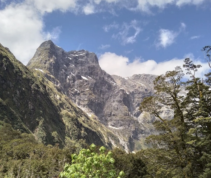
- 360-degree alpine views from pass shelter (weather permitting)—a panorama across the wild landscape you've entered
- Visit MacKinnon Memorial cairn honouring the track pioneer
- Long, knee-testing descent of 800 m via 11 Mile Valley into Arthur Valley
- OPTIONAL: 90-minute return detour to Sutherland Falls (580 m high)—one of New Zealand's tallest waterfalls
- Arrive Dumpling Hut (40 bunks) in lush rainforest near Sutherland Falls
- Most challenging and rewarding day—where legs, lungs, and resolve are tested
Day 4: Dumpling Hut to Sandfly Point
- Distance: 18 km
- Elevation: 454 m gain, various ups and downs
- Time: 5–6 hours
- Walk through pristine temperate rainforest alongside Arthur River
- Cross multiple swing bridges
- Pass Giant Gate Falls (spectacular cascade, particularly dramatic after rainfall)
- Lake Ada section with mountain views
- Finish at Sandfly Point (boat pickup to Milford Sound)
- Afternoon boat transfer (20 minutes) to Milford Sound/Piopiotahi
- Bus or scenic flight back to Te Anau or Queenstown
- Despite being the longest day distance-wise, generally the easiest physically—mostly flat along a wide, well-maintained gravel path
Important Notes:
- All huts must be pre-booked through DOC (book early—sells out within 30–45 minutes)
- Boat transfers at both ends are mandatory and must be booked separately
- Track is one-way only, walking south to north
- No camping allowed—must stay in designated huts
- Weather can change rapidly, especially at MacKinnon Pass
- Carry full waterproof gear and layers
- Sandflies are notorious—bring strong repellent (DEET 15–20% concentration)
Planning and Bookings
Book Your Trip
Everything you need to plan your journey
Accommodation
Find places to stay near Te Anau
Flights
Search flights to Te Anau
Essential Preparation
Securing a spot on the Milford Track is often harder than the walk itself. Three essential components must align perfectly: hut bookings, entry boat transfer, and exit boat transfer. Failure to coordinate any one element can unravel the entire trip. Build in buffer time for weather delays and consider basing in Te Anau before and after for transport flexibility and accommodation options.
Te Anau serves as the logistical hub for the walk, offering excellent accommodation (budget backpackers to mid-range hotels), dedicated outdoor retailers for last-minute gear purchases or repairs, supermarkets for food restocking, cafés and restaurants for celebration meals, and easy access to Te Anau Downs (30 minutes by bus or rental car).
Trail Accommodation
The Milford Track has three Department of Conservation (DOC) huts along the route: Clinton Hut, Mintaro Hut, and Dumpling Hut. Each hut accommodates 40 walkers and must be booked in advance during the Great Walks season.
Hut Facilities:
- Bunk beds with mattresses (sleeping bags required - no bedding provided)
- Common area with benches and tables
- Gas cookers with bench space (no pots or cooking equipment provided)
- Cold running water (stream water available, treatment recommended)
- Composting toilets
- Drying rooms (often inadequate in heavy rain)
- No electricity or charging facilities
- Resident warden during Great Walks season
What Huts Don't Provide:
- Food or cooking equipment
- Sleeping bags, pillows, or bedding
- Dishes, plates, cups, or cutlery
- Heating (huts are unheated but enclosed)
- Cell phone signal or WiFi
Booking Requirements:
- Bookings open once per year (28 May 2025 for 2025-2026 season)
- Extremely high demand - spots sell out within 30-45 minutes
- Must book all three huts for consecutive nights
- No camping allowed on track
- Hut costs: NZ$106 per night (NZ residents) or NZ$152 per night (international visitors)
Required Gear
- Tramping boots - waterproof, ankle support, broken in (blisters end dreams)
- Waterproof jacket - Gore-Tex or equivalent, taped seams essential for 9,000mm rainfall
- Waterproof overtrousers - full-length side zips for easy on/off in sudden downpours
- Sleeping bag - 3-season rated (comfort 0-5°C), huts are unheated but enclosed
- Tramping pack - 45-65L, rain cover included, hip belt crucial for multi-day comfort
- Head torch - with spare batteries, December sunset ~9:30pm but huts have no electricity
- First aid kit - bandaids, blister treatment, pain relief, personal medications
- Sandfly repellent - DEET 50%+ concentration, apply liberally at every stop (non-negotiable)
- Tent (optional) - for those planning camping alternatives
What to Bring
- Food for 4 days - breakfast, lunch, dinner, snacks (no food available on track, huts have no cooking facilities requiring fuel)
- Cooking gear - lightweight gas stove, pot, utensils, lighter/matches (huts have bench space but no stoves)
- Water treatment - filter or purification tablets (stream water plentiful but untreated)
- Plate, bowl, cup - lightweight camping set, huts have no dishes
- Toiletries - biodegradable soap, toothbrush/paste, toilet paper, hand sanitizer
- Sun protection - sunscreen SPF50+, sunglasses, hat (alpine sun intense even in cloud)
- Warm layers - merino base layer, insulating mid-layer, beanie, gloves (MacKinnon Pass 1,154m can be near-freezing)
- Emergency shelter - lightweight emergency blanket or bivvy bag
- Navigation - offline map app, compass, trail description printout (mobile signal non-existent)
- Personal locator beacon - recommended, DOC hires them (~NZ$60 for 4 days)
- Cash - NZ$50-100 for boat transfers (card payments unreliable in Milford Sound)
- Entertainment - book, cards, journal (hut evenings are social but long)
Permits
Bookings open once per year on a specific date announced by the Department of Conservation. For the 2025–2026 season, bookings open 28 May 2025. Competition is extremely fierce—the Milford Track's 40 daily independent walker spots regularly sell out within 30–45 minutes of the booking system going live.
Booking strategy:
- Create a DOC account well in advance (weeks, not days, before booking opens)
- Log in at 9:00 AM (the booking system lobby opens at 9:00 AM on booking day; early arrival improves your position)
- Enter the queue at 9:30 AM when the booking system officially opens. A new queue system assigns random positions to manage server load and prevent crashes
- Do not refresh your browser once you enter the queue—you will lose your place
- Have multiple flexible date ranges ready (at least 3–4 alternative week options)
- Keep your credit card accessible (payment must be completed immediately to secure the booking; there is no "reserve and pay later" option)
If you miss the initial booking rush: Don't immediately despair. Cancellations regularly surface 2–4 weeks before hiking dates as walkers' circumstances change. Persistent checking of the DOC website and monitoring can yield unexpected availability. Set phone reminders and check daily during the 2–4 week pre-booking window.
Hut Costs (Great Walks season: 28 October 2025 – 30 April 2026):
- New Zealand residents: NZ$106 per person, per night
- International visitors: NZ$152 per person, per night
- Children (5–17 years): Reduced rates (approximately 50% of adult cost)
- Total cost for three nights: NZ$318 (residents) or NZ$456 (international)
Off-season (1 May – 27 October 2025): Lower rates apply (approximately NZ$30 per night), but huts operate in basic winter mode, and the track is advanced-alpine only.
Boat Transfers and Logistics:
- Entry: Real Journeys or competing operators provide boat transport from Te Anau Downs to Glade Wharf. Journey time: approximately 1 hour 15 minutes
- Exit: From Sandfly Point to Milford Sound/Piopiotahi (20 minutes), where onward buses return you to Te Anau or Queenstown
- Buffer days: Strongly recommended to build in at least one extra day before or after your booked walk dates. Fiordland storms can close Ōmanui/MacKinnon Pass for days at a time, and you'll need flexibility if your walk is delayed or extended
Other Activities in the Area
Consider extending your trip to experience more of this remarkable landscape:
- Milford Sound cruises: The classic way to finish your hike. View the fiord from the water with waterfalls cascading directly into the sea, spot fur seals at Seal Rock, see Mitre Peak rising 1,692 m straight from the water. Real Journeys and other operators offer various cruise options, some with onboard dining or special wildlife focus.
- Sea kayaking in Piopiotahi: Paddle beneath towering cliffs for an intimate, self-powered perspective on the fiord's scale and waterfalls.
- Te Anau Glowworm Caves: A unique geological adventure across Lake Te Anau to an underground world of bioluminescent glowworms in a cavern network.
- Helicopter tours of Fiordland: See the valleys you just walked from above, with aerial views of Sutherland Falls, the glaciated landscape, and perspectives impossible from ground level.
- Te Anau lakefront: Reward yourself with excellent cafés and restaurants overlooking the lake, walk the shoreline, or swim in summer.
- Lake Manapouri cruise and Doubtful Sound: An extension that takes you through another spectacular fiord system (though more time-intensive than day trips).
Safety and Conditions
Pre-Departure Checks:
- Check MetService mountain forecast and severe weather warnings before departure
- Review DOC track alerts and closures for Fiordland National Park on the DOC website (updated daily during Great Walks season)
- Verify SH94 Milford Road status before arranging return transport—avalanches and major slips can close the road to Milford Sound for days or weeks
- Monitor real-time weather reports as your start date approaches; have contingency plans if heavy rain warnings are issued
Alpine Pass Hazards: Be prepared for rapid weather changes at Ōmanui/MacKinnon Pass—the reality can be vastly different from morning forecasts. Expect strong, sometimes violent winds, heavy rain and sleet, near-zero visibility (cloud can envelope the pass within minutes), hypothermia risk even in summer (altitude and wind chill create genuine cold), and snow and ice from May through October (expert-only terrain outside Great Walks season).
Flood Risk: The Milford Track is not an all-weather track. Both the Clinton and Arthur Valleys become impassable during heavy rain due to flooding. Heavy rain also significantly increases avalanche risk and landslide probability. If a heavy rain warning is issued during your scheduled hiking dates, postpone your walk until weather improves. Attempting to walk during heavy rain warnings is genuinely dangerous—rivers that are knee-deep can become waist-deep or worse within hours.
Sandflies: Sandflies are endemic to Fiordland and reach peak numbers during summer months (December–February). They are tiny (2–3 mm) but aggressive biters. Effective management strategies include carrying strong DEET-based repellent (15–20% DEET concentration; apply generously and reapply frequently), covering exposed skin when stationary, applying repellent before entering a sandfly zone, avoiding eating outside if possible, and keeping moving (sandflies are weak fliers).
Travel insurance is strongly recommended to cover potential medical emergencies, evacuation, and trip cancellations.
Side Trips and Points of Interest
Sutherland Falls: The crown jewel of Milford Track detours. At 580 metres, this is the tallest waterfall in New Zealand and among the world's highest. Water plunges from Lake Quill in three spectacular cascades: upper (229 m), middle (248 m), and lower (103 m) leaps. The 90-minute return trip from Quintin Shelter (near Dumpling Hut) is absolutely worth the effort—stand at the base and feel the thundering spray, experience the power of water falling over 480 m of horizontal distance at approximately 56-degree angle, and understand why Donald Sutherland's discovery of these falls in 1880 made him a local legend. Sunrise or early morning visits offer better light and fewer other walkers.
Giant Gate Falls: A powerful, photogenic cascade accessed via swing bridge on Day 4, near Lake Ada. The waterfall is particularly dramatic after rainfall when water volume increases dramatically. The perfect location to pause, capture a final waterfall photograph before journey's end, and reflect on the landscapes you've traversed.
MacKinnon Memorial: A historic stone cairn at Ōmanui/MacKinnon Pass commemorating Quintin MacKinnon's traverse of the route in 1888. In clear conditions, this memorial sits at one of Fiordland's finest viewpoints—a 360-degree panorama across the Clinton Canyon you just ascended, the Arthur Valley stretching before you, and surrounding peaks creating a landscape of staggering scale. The memorial has been visited by thousands of trampers; many leave coins or small tokens of gratitude for safe passage.
Arthur Valley Viewpoints: Countless cascades and ancient moss-draped forest sections line Day 4's route through the Arthur Valley, particularly dramatic after rainfall when every cliff face becomes a temporary waterfall. The fern understory, epiphytic lichens, and dripping dampness create a rainforest ecosystem that feels prehistoric and otherworldly. Early morning walks on Day 4 offer the greatest solitude and best light for photography.
Leave No Trace

You are walking through a UNESCO World Heritage Area—an ecosystem that is ancient, fragile, and irreplaceable. This landscape has been shaped by millions of years of geological evolution; its biodiversity represents living examples of Gondwanaland-era ecology. The Milford Track's limited daily numbers (40 independent walkers maximum) exist precisely to protect this wilderness for future generations.
Your responsibility as a walker:
- Pack out everything you pack in, including all food scraps, soiled toilet paper (use the hut toilet facilities), and micro-trash
- Use biodegradable soap and wash well away from waterways (minimum 10 m from streams)
- Stay on the marked track to protect fragile vegetation (mosses, lichens, small plants) that can take decades to recover from a single footprint
- Never feed the kea (the endangered mountain parrot). These intelligent birds are killed by inappropriate human food and are classified as Nationally Endangered
- Minimise noise and avoid playing music or loud voices—part of the Milford Track's value is the silence and solitude of wilderness
- Use hut composting toilets correctly (follow posted instructions)
- Respect heritage sites like the MacKinnon Memorial (look, don't deface)
Tread lightly. Leave only footprints. The Milford Track is a privilege, not a right—walk it with humility and respect for the landscape and its Māori heritage.