Manaslu Circuit - The Spirit of the Eighth Giant
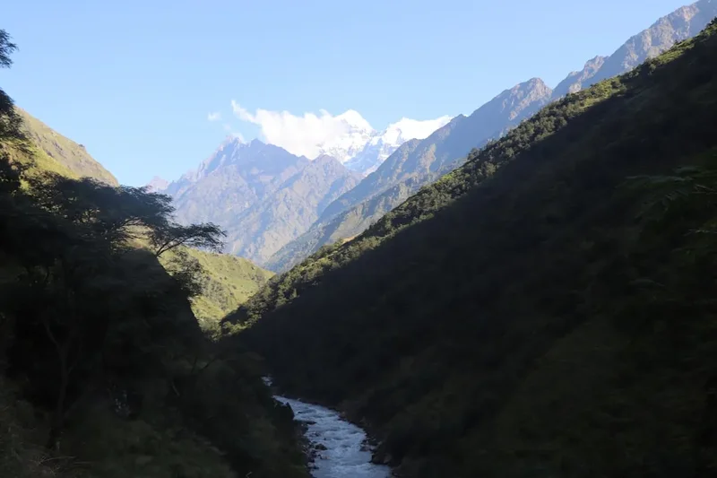
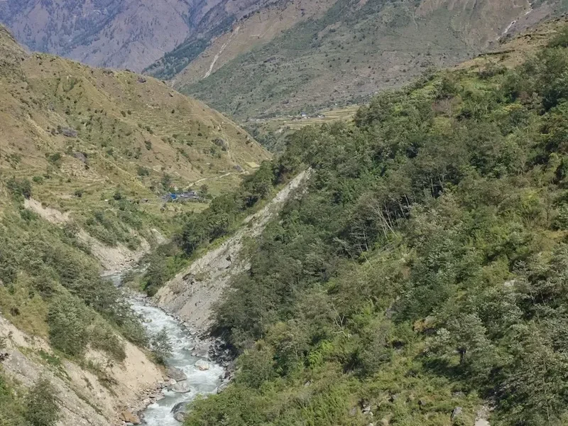
The Manaslu Circuit is widely regarded as the premier alternative to the Annapurna Circuit, offering a raw, authentic, and culturally immersive trekking experience through the remote Gorkha region of Nepal. Circling the world’s eighth-highest mountain, Mount Manaslu (8,163 metres), this 177-kilometre journey is a masterclass in geographical and cultural transition. The trail begins in the humid, subtropical lowlands of the Budhi Gandaki River valley, where lush jungles and terraced rice paddies dominate the landscape, before ascending through ancient pine forests and eventually emerging into the stark, high-altitude alpine deserts of the Tibetan borderlands. The climax of the trek is the crossing of the formidable Larkya La Pass at 5,106 metres, a challenging physical feat that rewards trekkers with unparalleled views of the Manaslu massif, Himlung Himal, and the Annapurna range.
Unlike the more commercialised trekking routes in the Everest or Annapurna regions, the Manaslu Circuit remains a "restricted area," requiring a mandatory guide and a minimum of two trekkers to obtain permits. This regulation has preserved the trail's rugged character and ensured that the local communities—primarily of Gurung and Tibetan descent—maintain their traditional way of life. From the Hindu-influenced villages of the lower valleys to the Buddhist monasteries (gompas) and mani walls of the upper highlands, the Manaslu Circuit is as much a spiritual pilgrimage as it is a physical challenge. It is a journey for those seeking solitude, spectacular mountain scenery, and a deep connection with the Himalayan wilderness.
- Distance: 177.0 km (approximate, depending on side trips)
- Duration: 12–20 days
- Season: October–November (Autumn) or April–May (Spring)
- Accommodation: Teahouses (basic mountain lodges)
- Highest point: Larkya La Pass (5,106 m)
- Difficulty: Challenging (requires high fitness and acclimatisation)
- Permits: Restricted Area Permit (RAP), MCAP, and ACAP required
- Direction: Counter-clockwise (standard for acclimatisation)
Overview
The Manaslu Circuit is often described as the "Great Himalayan Trail" in miniature. Its primary appeal lies in its incredible diversity. Over the course of two weeks, trekkers experience a vertical gain that spans several distinct ecological zones. The journey starts at an elevation of roughly 700 metres in Machha Khola, where the air is thick and warm, and the Budhi Gandaki River thunders through deep, narrow gorges. As you move north, the valley opens up, and the vegetation shifts from broadleaf forests to rhododendron, blue pine, and bamboo. By the time you reach the village of Lho, the first dramatic views of Manaslu’s "double peak" appear, dominating the skyline with its sheer granite faces and hanging glaciers.
The cultural landscape is equally transformative. The lower reaches of the trek are inhabited by the Gurung and Magar ethnic groups, known for their terraced farming and distinct Hindu-Buddhist syncretism. However, as the trail climbs towards the Tibetan border, the influence of "Bhotia" culture becomes absolute. Villages like Samagaon and Samdo feel like relics of a bygone era, with stone houses, prayer flags fluttering in the wind, and ancient monasteries that have served as spiritual hubs for centuries. The people here share a close linguistic and cultural affinity with Tibet, and the proximity to the border is palpable in the architecture, dress, and religious practices.
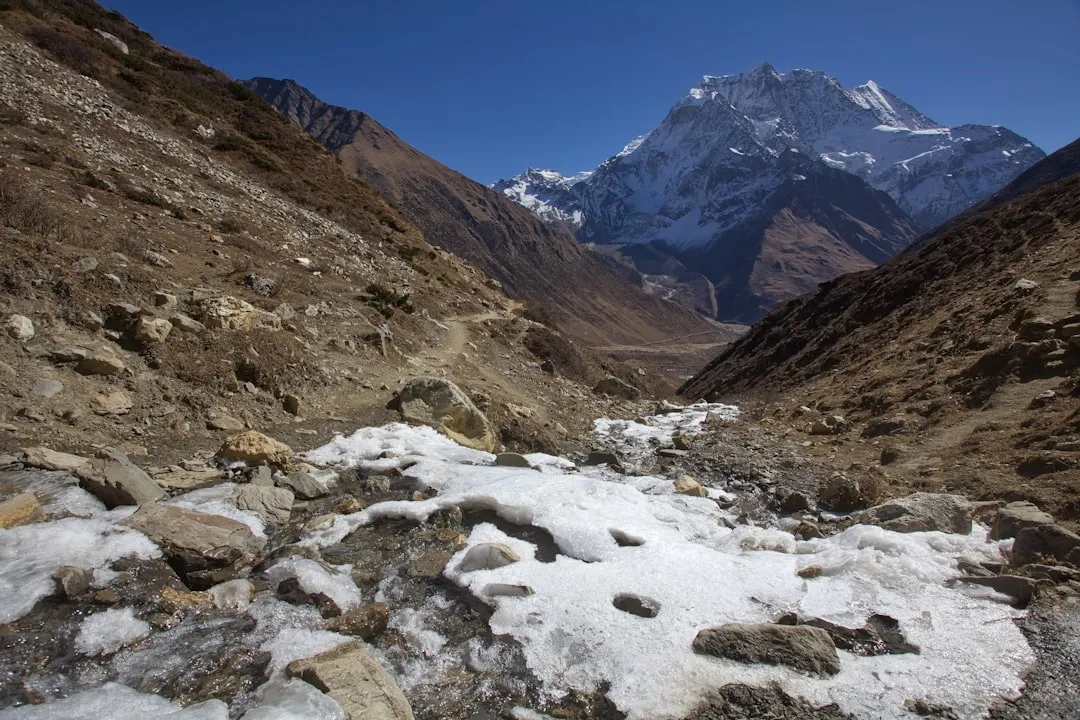
The physical demand of the Manaslu Circuit should not be underestimated. While the daily distances are manageable, the cumulative effect of altitude and the steepness of the terrain requires significant stamina. The crossing of the Larkya La Pass is the definitive crux of the route. It involves a long, pre-dawn ascent over rocky moraine and potentially snow-covered slopes, followed by a steep and demanding descent into the Marsyangdi Valley. However, the sense of achievement upon reaching the prayer-flag-strewn summit of the pass, surrounded by 7,000 and 8,000-metre peaks, is a highlight that stays with trekkers for a lifetime. With the recent improvement of teahouse facilities, the trek no longer requires a full camping expedition, making this wild frontier accessible to fit, experienced hikers who crave a more secluded Himalayan adventure.
History and Cultural Context
The history of the Manaslu region is deeply intertwined with the ancient salt trade routes that once connected the Tibetan plateau with the middle hills of Nepal. For centuries, caravans of yaks and mules traversed these high passes, exchanging Tibetan salt and wool for Nepalese grain and spices. This economic exchange fostered a unique cultural melting pot, particularly in the upper Nupri valley, where the inhabitants are descendants of Tibetan migrants who settled in the region over 500 years ago. The name "Manaslu" is derived from the Sanskrit word *Manasa*, meaning "intellect" or "soul," and is often translated as the "Mountain of the Spirit." To the local people, the mountain is a sacred deity, and its presence is felt in every aspect of daily life.
Mount Manaslu itself has a storied mountaineering history. It was first summited in 1956 by a Japanese expedition led by Toshio Imanishi and Gyalzen Norbu. Because of this first ascent, Manaslu has always held a special place in the hearts of Japanese climbers, much like Everest does for the British. However, the trekking route around the mountain remained closed to foreigners for decades due to its proximity to the sensitive Tibetan border. It wasn't until 1991 that the Nepalese government officially opened the Manaslu Circuit to organised trekking groups, and even then, strict permit quotas and the requirement for a government-licensed guide were maintained to protect the region's fragile environment and culture.
In recent history, the region faced a significant challenge during the devastating Gorkha earthquake of April 2015. The epicentre was located near the Barpak village, not far from the Manaslu trail. Many villages suffered extensive damage, and landslides temporarily blocked several sections of the route. However, the resilience of the local communities, supported by international aid and the determination of the trekking industry, led to a remarkable recovery. Today, the teahouses have been rebuilt to higher safety standards, and the trail is fully operational, serving as a vital economic lifeline for the people of the Budhi Gandaki valley. Walking this trail today is not just a scenic journey; it is a way to support the continued revitalisation of a region that has overcome immense hardship.
Want more background? Read extended notes on history and cultural context → Learn more
Seasonal Highlights and Weather Reality
Timing is everything when planning a Manaslu Circuit trek. The weather in the Himalayas is notoriously fickle, and the high altitude of the Larkya La Pass means that certain times of the year are significantly safer and more enjoyable than others.
Autumn (October to November): This is widely considered the "goldilocks" season for Manaslu. Following the monsoon rains, the atmosphere is washed clean of dust, resulting in the sharpest, most brilliant mountain views. The temperatures are moderate at lower elevations and crisp but manageable at higher altitudes. This is also the busiest time on the trail, though "busy" in Manaslu is still far quieter than the Everest Base Camp trek. The Larkya La Pass is usually clear of deep, fresh snow, making the crossing more predictable.
Spring (April to May): The second most popular window. The highlight of spring is the flora; the rhododendron forests of the lower and middle valleys erupt in shades of crimson, pink, and white. As the winter snow begins to melt, the waterfalls are at their most powerful. Temperatures are slightly warmer than in autumn, though there is a higher chance of afternoon clouds and occasional spring showers. For those interested in mountaineering, this is also the season when Manaslu base camp is bustling with expeditions.
Winter (December to February): Trekking in winter is a serious undertaking. While the skies are often crystal clear, the temperatures at Samagaon and Samdo can drop to -20°C at night. Most importantly, the Larkya La Pass frequently becomes impassable due to heavy snow and high winds. Many teahouses in the upper villages close for the season as locals migrate to lower elevations. Only highly experienced trekkers with professional cold-weather gear and flexible schedules should consider this window.
Monsoon (June to September): This is the least favourable time to trek. The Manaslu region receives heavy rainfall, which leads to frequent landslides in the narrow Budhi Gandaki gorge, potentially cutting off the trail for days. Leeches are a significant nuisance in the lower forests, and the mountains are almost constantly shrouded in cloud. Furthermore, the heat and humidity in the lowlands can be oppressive. Trekking during the monsoon is generally discouraged due to safety risks and poor visibility.
Recommended Itinerary
14-Day Manaslu Circuit Itinerary
Day 1: Kathmandu to Machha Khola
- Distance: 160 km (Drive)
- Elevation: 870 m
- Time: 8–10 hours
- Long, bumpy drive by local bus or private 4WD
- Follow the Trishuli River before turning north towards Gorkha
- Pass through Arughat and Soti Khola
- Overnight in Machha Khola, a bustling trailhead village
Day 2: Machha Khola to Jagat
- Distance: 22 km
- Elevation gain: 470 m
- Time: 6–7 hours
- Follow the Budhi Gandaki River upstream
- Cross several suspension bridges and pass the natural hot springs at Tatopani
- The valley narrows into a dramatic gorge
- Register permits at the police checkpoint in Jagat
- Jagat is a beautiful village with flagstone-paved streets
Day 3: Jagat to Deng
- Distance: 19 km
- Elevation gain: 460 m
- Time: 6–7 hours
- Ascend through rocky ridges to Salleri and Sirdibas
- Cross the long suspension bridge at Philim
- Enter the restricted area officially after Philim
- The landscape shifts from subtropical to temperate forest
- Arrive in Deng, a small village with a distinct Tibetan influence
Day 4: Deng to Namrung
- Distance: 19 km
- Elevation gain: 830 m
- Time: 6–7 hours
- A significant day for elevation gain
- Pass through Bihi Phedi and Ghap
- The trail winds through dense forests of fir, rhododendron, and oak
- Look for grey langur monkeys in the trees
- Namrung offers the first great views of Siringi Himal and Ganesh Himal
Day 5: Namrung to Lho
- Distance: 11 km
- Elevation gain: 550 m
- Time: 4 hours
- A shorter day to assist with acclimatisation
- Pass through the village of Lihi with its many chortens
- Enter the Nupri region where Tibetan culture is dominant
- Arrive in Lho, famous for its massive monastery (Ribung Gompa)
- Spectacular sunset views of Mount Manaslu from the village
Day 6: Lho to Samagaon
- Distance: 17 km
- Elevation gain: 350 m
- Time: 4–5 hours
- Pass through Shyala village with 360-degree mountain views
- The valley opens up into wide glacial flats
- Arrive in Samagaon, the largest and most important village in the region
- Samagaon sits at the foot of Manaslu and serves as the primary acclimatisation hub
Day 7: Acclimatisation Day in Samagaon
- Elevation: 3,530 m
- Rest day to allow the body to adjust to the thinning air
- Optional hike to Birendra Lake (glacial lake) - 1.5 hours return
- Optional hike to Manaslu Base Camp (4,800 m) - 6–8 hours return (strenuous)
- Optional visit to Pungyen Gompa for views of the glacier
- Explore the ancient stone houses and monasteries of the village
Day 8: Samagaon to Samdo
- Distance: 16 km
- Elevation gain: 330 m
- Time: 3–4 hours
- Easy walk along the upper Budhi Gandaki River
- Pass several long mani walls (prayer stone walls)
- The tree line disappears, replaced by juniper and tundra
- Samdo is a remote village settled by Tibetan refugees, located near the border
- Afternoon hike up Samdo Peak for acclimatisation
Day 9: Samdo to Dharmasala (Larkya Phedi)
- Distance: 12 km
- Elevation gain: 600 m
- Time: 4 hours
- Cross the wooden bridge over the Budhi Gandaki for the last time
- Ascend towards the Larkya Glacier
- Dharmasala is not a village but a high-altitude seasonal settlement
- Accommodation is basic (often stone huts or fixed tents)
- Early dinner and sleep in preparation for the pass crossing
Day 10: Dharmasala to Bimthang via Larkya La Pass
- Distance: 24 km
- Elevation: 646 m gain to pass, 1,516 m descent
- Time: 8–10 hours
- The longest and hardest day of the trek
- Pre-dawn start (usually 3:00 AM or 4:00 AM)
- Steady climb over glacial moraine to the summit of Larkya La (5,106 m)
- Panoramic views of Himlung Himal, Cheo Himal, and Annapurna II
- Long, steep descent on loose scree and potentially snow
- Arrive in the beautiful valley of Bimthang, surrounded by peaks
Day 11: Bimthang to Dharapani
- Distance: 26 km
- Elevation loss: 1,730 m
- Time: 7–8 hours
- Descent through pristine forests of pine and rhododendron
- Follow the Dudh Khola river downstream
- Pass through the village of Tilije (famous for its local apple brandy)
- Join the main Annapurna Circuit trail at Dharapani
- Check out of the Manaslu Restricted Area
Day 12: Dharapani to Besisahar and Kathmandu
- Distance: 200 km (Drive)
- Time: 8–10 hours
- Take a local jeep from Dharapani to Besisahar (rough road)
- Transfer to a private car or bus for the drive back to Kathmandu
- Celebratory dinner in Thamel
Important Notes:
- Itinerary can be extended by 3–4 days to include the Tsum Valley detour
- Acclimatisation days are non-negotiable for safety
- Walking times are estimates and vary based on fitness and weather
- Always follow the advice of your licensed guide regarding pass conditions
Planning and Bookings
Book Your Trip
Everything you need to plan your journey
Accommodation
Find places to stay near Kathmandu
Flights
Search flights to Kathmandu
Essential Preparation
The Manaslu Circuit requires more logistical planning than the standard Everest or Annapurna treks due to its "Restricted Area" status. You cannot trek this route solo; the Nepalese government mandates that all trekkers must be accompanied by a licensed guide and be part of a group of at least two people. If you are a solo traveller, your trekking agency can usually pair you with another trekker or process your permit with a "ghost" second passport (though this is increasingly scrutinised).
Physical preparation is crucial. You should be capable of walking 6–8 hours a day for multiple consecutive days with a 5–8 kg daypack. Focus on cardiovascular training (hiking, running, cycling) and leg strength. If possible, do several practice hikes in your trekking boots to ensure they are well broken in. Kathmandu is the primary hub for all logistics. You should arrive at least two full days before your trek to allow the agency to process your original passport for the Restricted Area Permit.
Trail Accommodation
Accommodation on the Manaslu Circuit is provided by teahouses. These are small, family-run lodges that offer basic lodging and meals. While the quality has improved significantly in recent years, they remain simpler than those found on the Everest trail.
Hut Facilities:
- Twin-share rooms with two single beds and thin mattresses
- Common dining area, usually heated by a central wood or yak-dung stove
- Common toilets (increasingly "sit-down" style in lower villages, "squat" style in higher areas)
- Blankets are usually provided, but a high-quality sleeping bag is essential for hygiene and warmth
- Hot showers are available in most villages for an extra fee (US$3–5), usually heated by gas or solar
- Electricity for charging devices is available in the dining area for a small fee
- WiFi is available in many villages (via Everest Link or local networks) but becomes unreliable at higher altitudes
What Teahouses Don't Provide:
- Towels, soap, or toiletries
- Consistent heating in bedrooms (rooms are unheated and can be very cold)
- Laundry services (except for basic hand-washing basins)
- Unlimited free drinking water (bottled water is discouraged; boiled or filtered water is sold)
Required Gear
- Trekking boots - high-cut, waterproof, and thoroughly broken in
- Down jacket - rated for -15°C, essential for evenings and the pass crossing
- Sleeping bag - 4-season rated (comfort level -10°C to -15°C)
- Trekking trousers - convertible or soft-shell, plus a pair of thermal leggings
- Waterproof shell - high-quality jacket and trousers (Gore-Tex or similar)
- Backpack - 40–50L if you have a porter, 60–70L if you are carrying your own gear
- Trekking poles - highly recommended for the steep descent from Larkya La
- Head torch - with spare batteries for the pre-dawn pass crossing
- Micro-spikes - essential if trekking in early spring or late autumn when the pass may be icy
What to Bring
- Water purification - Katadyn BeFree filter, Grayl bottle, or chlorine/iodine tablets
- Snacks - energy bars, nuts, dried fruit, and chocolate (expensive to buy on the trail)
- First aid kit - including Diamox (for altitude), antibiotics, blister pads, and rehydration salts
- Sun protection - SPF 50+ sunscreen, lip balm with SPF, and category 4 sunglasses
- Toiletries - biodegradable wet wipes, hand sanitiser, toilet paper, and a quick-dry towel
- Power bank - high capacity (20,000mAh) to keep phone and camera charged
- Cash - Nepalese Rupees (NPR) for all on-trail expenses (allow US$30–40 per day for food, showers, and charging)
- Personal documents - copies of your passport, insurance policy, and extra passport photos
Permits

The Manaslu Circuit requires three distinct permits. These cannot be obtained by individuals; they must be processed by a registered Nepalese trekking agency. You must provide your original passport and a copy of your Nepal visa to the agency in Kathmandu for processing.
1. Manaslu Restricted Area Permit (RAP):
- September to November: US$100 for the first seven days, then US$15 per additional day
- December to August: US$75 for the first seven days, then US$10 per additional day
- This permit is required from Jagat until you cross the pass and reach Dharapani
2. Manaslu Conservation Area Project (MCAP) Permit:
- Cost: 3,000 NPR (approx. US$25)
- No time limit; valid for a single entry
3. Annapurna Conservation Area Project (ACAP) Permit:
- Cost: 3,000 NPR (approx. US$25)
- Required because the trail ends in the Annapurna region (Dharapani to Besisahar)
Important Permit Regulations:
- A minimum of two trekkers is required for the RAP
- A government-licensed guide is mandatory
- Permits are checked at multiple police checkpoints (Jagat, Philim, Namrung, Samdo, and Dharapani). Ensure your guide handles the registration at each stop
- The TIMS (Trekkers' Information Management Systems) card is currently not required for Manaslu if you have the RAP, but regulations change frequently; check with your agency
Other Activities in the Area
If you have extra time or want to enrich your Himalayan experience, consider these additions:
- Tsum Valley Detour: A 7–10 day extension into the "Hidden Valley of Happiness." This is a deeply spiritual region where the ancient form of Buddhism is preserved. It adds significant cultural depth but requires an additional restricted area permit.
- Manaslu Base Camp Hike: From Samagaon, a strenuous day hike takes you to the base of the mountain (4,800 m). You can see the crampon-point of the climbing route and meet expedition teams during the climbing season.
- Birendra Lake: A stunning turquoise glacial lake just a short walk from Samagaon. It is a perfect spot for a quiet afternoon of reflection during your acclimatisation day.
- Pungyen Gompa: A hidden monastery located on a high plateau with incredible views of the Manaslu glacier. It was destroyed by an avalanche in the 1950s (blamed by locals on the first Japanese expedition) and later rebuilt.
- Kathmandu Sightseeing: Before or after your trek, visit the UNESCO World Heritage sites of Boudhanath Stupa, Pashupatinath Temple, and Swayambhunath (the Monkey Temple).
- Pokhara Extension: After finishing the trek in Besisahar, take a bus to Pokhara to relax by Phewa Lake and enjoy the comforts of a lakeside resort.
Safety and Conditions
Altitude Sickness (AMS): This is the primary safety concern on the Manaslu Circuit. The trail ascends from 800 m to over 5,000 m. It is essential to follow the "climb high, sleep low" principle. Never skip the acclimatisation days in Samagaon. Recognise the symptoms of AMS: headache, nausea, dizziness, and loss of appetite. If symptoms persist or worsen, you must descend immediately. Your guide should be trained in wilderness first aid and altitude management.
Larkya La Pass Conditions: The pass is high and exposed. Weather can change in minutes. High winds and whiteout conditions are possible even in peak season. If your guide or the locals in Samdo suggest the pass is unsafe due to snow or wind, respect their decision. The descent on the western side is very steep and can be slippery; use trekking poles and consider micro-spikes if there is ice.
River Crossings and Landslides: The Budhi Gandaki gorge is prone to landslides, especially after heavy rain. Always keep an eye on the slopes above you in narrow sections. When crossing suspension bridges, wait for mule or yak caravans to pass completely before stepping onto the bridge. Always stay on the "mountain side" of the trail when passing animals to avoid being accidentally pushed off the edge.
Water Safety: Never drink untreated tap or stream water. Use a high-quality filter or purification tablets. Dehydration exacerbates altitude sickness, so aim to drink 3–4 litres of treated water per day.
Insurance: Ensure your travel insurance specifically covers trekking up to 6,000 metres and includes emergency helicopter evacuation. Standard policies often cap coverage at 3,000 or 4,000 metres.
Side Trips and Points of Interest
The Mani Walls of Lho and Samagaon: The upper Manaslu region contains some of the longest and most intricate mani walls in Nepal. These are walls made of stones carved with the Buddhist mantra "Om Mani Padme Hum." Tradition dictates that you should always pass these walls on the left side (clockwise), keeping the wall to your right. They are beautiful examples of local devotion and craftsmanship.
Ribung Gompa (Lho): This monastery sits on a hill overlooking the village of Lho. It houses a large community of monks and offers one of the most iconic views in the Himalayas: the monastery’s golden roof framed perfectly against the backdrop of Mount Manaslu. Visiting during morning or evening prayers is a profound experience.
Tibetan Border (Rui La): From Samdo, it is possible to take a long day trip to the Rui La pass (4,998 m) on the border with Tibet. While you cannot cross the border, you can see the Chinese border markers and look out over the vast Tibetan plateau. This requires an extra day and excellent fitness.
Tilije Village: On the descent from Bimthang, Tilije is a culturally rich village inhabited by the Gurung people. It is famous for its traditional architecture and the production of local apple brandy. It is a much more pleasant place to stay than the busier village of Dharapani.
Leave No Trace
The Manaslu region is a fragile ecosystem under increasing pressure from tourism. As a trekker, you have a responsibility to minimise your impact on this pristine environment.
Your responsibility as a walker:
- Plastic Waste: Avoid buying bottled water. Use a filter or purification tablets to treat tap water. Carry out all your own plastic waste, including snack wrappers and empty toiletry bottles.
- Human Waste: Always use the toilets provided by teahouses. If you are caught short on the trail, bury waste at least 20 cm deep and 50 metres away from water sources. Pack out your used toilet paper in a sealed bag.
- Respect Wildlife: Do not feed or disturb the Himalayan tahr, blue sheep, or langur monkeys. Keep a respectful distance from all animals, including domestic yaks and mules.
- Cultural Sensitivity: Always ask for permission before taking photos of people or the interior of monasteries. Dress modestly (shoulders and knees covered), especially in villages and religious sites.
- Energy Conservation: Be mindful of the limited fuel resources. If the teahouse uses wood for heating, keep the dining room door closed to retain heat. Avoid asking for hot bucket showers if they are heated by wood.
- Stay on the Trail: Do not take shortcuts on switchbacks, as this causes soil erosion and damages fragile alpine vegetation.