
Manaslu Base Camp Trek - The Spirit of the Himalayas
The Manaslu Base Camp Trek is one of Nepal’s most profound and visually spectacular mountain journeys, offering a raw, tea-house-based alternative to the more crowded Everest and Annapurna circuits. Centred around Mount Manaslu (8,163 metres), the eighth-highest peak in the world, this 177-kilometre trek circumnavigates the "Mountain of the Spirit" in a dramatic display of ecological and cultural transition. The route begins in the lush, subtropical lowlands of the Budhi Gandaki River valley, where rice paddies and banana trees thrive, and ascends through ancient rhododendron forests and alpine meadows before culminating in the high-altitude drama of the Larkya La Pass at 5,106 metres. This is a restricted area trek, meaning it remains less commercialised and more pristine than its counterparts, requiring a special permit and a mandatory licensed guide. For the intrepid trekker, it offers a rare opportunity to witness the authentic Tibetan-influenced culture of the Nubri and Tsum people, set against a backdrop of some of the most formidable granite spires and glacial icefalls on the planet.
- Distance: 177.0 km (full circuit including base camp excursion)
- Duration: 12–14 days
- Season: October–November (autumn) or April–May (spring)
- Accommodation: Local teahouses (lodges)
- Highest point: Larkya La Pass (5,106 m) / Manaslu Base Camp (4,800 m)
- Difficulty: Challenging (requires high fitness and altitude acclimatisation)
- Permits: Restricted Area Permit (RAP), Manaslu Conservation Area Permit (MCAP), Annapurna Conservation Area Permit (ACAP)
Overview
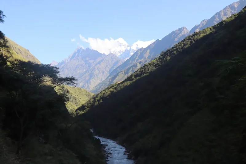
The Manaslu Base Camp Trek is a masterclass in Himalayan diversity. Unlike many treks that stay within a single climatic zone, this journey is a vertical odyssey that spans nearly 4,500 metres of elevation gain. The trek is traditionally walked in a counter-clockwise direction to allow for safe, gradual acclimatisation as you follow the Budhi Gandaki River upstream. The lower sections of the trail are characterised by deep, humid gorges, suspension bridges that sway hundreds of metres above thundering white water, and a landscape that feels more like a jungle than a mountain range. As you gain altitude, the scenery undergoes a radical transformation. The broad-leafed forests give way to pine, then larch, and finally the stark, wind-scoured beauty of the high alpine zone where only the hardiest shrubs and lichens survive.
The cultural transition is equally striking. In the lower villages like Soti Khola and Machha Khola, the population is predominantly Hindu, with terraced fields of millet and corn. However, as you cross into the "Restricted Area" beyond Jagat, the influence of Tibetan Buddhism becomes dominant. You will pass through villages adorned with colourful prayer flags, intricately carved mani walls (prayer stones), and ancient monasteries (gompas) that have stood for centuries. The peak of Mount Manaslu itself—a double-headed summit that resembles a serrated tooth—dominates the skyline for much of the upper trek, particularly from the villages of Lho and Samagaon. The side trip to Manaslu Base Camp (4,800 m) from Samagaon is a highlight of the journey, offering trekkers a close-up view of the massive Manaslu Glacier and the technical climbing routes used by mountaineers attempting the summit.
The final challenge of the trek is the crossing of the Larkya La Pass. This is a long, demanding day that requires an early start (often 3:00 AM or 4:00 AM) to avoid the fierce afternoon winds that scour the pass. The descent from the pass into the Bimthang Valley offers some of the most breathtaking views in the Himalayas, with the massive peaks of Himlung Himal, Cheo Himal, and Annapurna II framing the horizon. This trek is not merely a physical challenge; it is a journey through a living museum of Himalayan life, where the pace of existence is still dictated by the seasons and the mountains.
History and Cultural Context
Mount Manaslu, known in Sanskrit as "Manasa" (meaning "intellect" or "soul"), is often referred to as the "Mountain of the Spirit." Its history is deeply intertwined with Japanese mountaineering. While the British claimed Everest and the French claimed Annapurna, Manaslu became known as "the Japanese mountain." The first successful ascent was made in 1956 by Toshio Imanishi and Gyalzen Norbu, members of a Japanese expedition. This connection remains strong today, with many Japanese trekkers and climbers visiting the region to pay their respects to the peak that defined their nation's golden age of exploration.
The region is home to two distinct ethnic groups: the Nubri and the Tsum. The Nubri people inhabit the upper Manaslu valley, and their culture, language, and dress are almost identical to those of their neighbours in Tibet. For centuries, this valley served as a vital trade route between Nepal and Tibet, with salt and wool being exchanged for grain and spices. The closure of the border in the mid-20th century changed the economic landscape, but the cultural ties remain unbreakable. The Tsum Valley, which branches off the main Manaslu circuit, is a "Beyul"—a sacred hidden valley of Buddhism where the killing of any living being is strictly prohibited. This spiritual ethos permeates the entire region, creating an atmosphere of profound peace and reverence for nature.
The Manaslu region was significantly impacted by the 2015 Gorkha earthquake, as the epicentre was located nearby. Many teahouses and trails were damaged or destroyed. However, the resilience of the local people and international aid efforts have seen the region fully recover. Today, the teahouses are newer and more robust than before, and the trail has been meticulously rebuilt, often with improved safety features. Walking this track today is not only a personal adventure but also a way to support the continued economic recovery of these remote mountain communities.
Want more background? Read extended notes on history and cultural context → Learn more
Seasonal Highlights and Weather Reality
Timing is everything when planning a trek in the Manaslu region. The weather dictates not only the views but also the safety of the Larkya La Pass crossing. There are two primary windows for trekking: autumn and spring.
Autumn (October to November): This is widely considered the "gold standard" for Manaslu. Following the monsoon, the air is scrubbed clean of dust, offering the sharpest, most crystalline views of the peaks. The weather is generally stable, with clear blue skies during the day. However, temperatures drop significantly at night, especially above 3,500 metres, where they can easily reach -10°C or -15°C. This is also the busiest time on the trail, though "busy" here is still a fraction of the crowds found in the Everest region.
Spring (April to May): This is the season of rebirth. The lower forests erupt in a riot of colour as the rhododendrons—Nepal’s national flower—bloom in shades of red, pink, and white. The weather is warmer than in autumn, but there is a higher chance of afternoon clouds and occasional spring showers. For those interested in mountaineering culture, this is when the Manaslu Base Camp is most active with expeditions preparing for summit attempts. The Larkya La Pass usually has more snow in spring, which can make the crossing more physically demanding but visually stunning.
Winter (December to February): Trekking during winter is possible but extremely challenging. Most teahouses above 3,500 metres close as the locals migrate to lower elevations to escape the cold. The Larkya La Pass is often blocked by deep snow, requiring technical skills and equipment. Temperatures can plummet to -25°C at high altitudes. This is only for highly experienced winter trekkers who are prepared for self-sufficiency.
Monsoon (June to September): This is the least desirable time to trek. The region experiences heavy rainfall, leading to frequent landslides and leeches in the lower forest sections. Clouds usually obscure the mountain views, and the humidity makes the lower sections of the trek uncomfortable. However, the Tsum Valley, which sits partially in a rain shadow, can be a viable option for those who don't mind the logistical challenges of reaching it during the rains.
Recommended Itinerary
14-Day Manaslu Circuit & Base Camp Itinerary
Day 1: Kathmandu to Soti Khola
- Distance: 140 km (by road)
- Elevation: 710 m
- Time: 8–10 hours (drive)
- Depart Kathmandu early by private jeep or local bus
- Travel through scenic foothills and along the Trishuli River
- The road becomes rough and unpaved after Arughat
- Arrive at Soti Khola, a bustling trailhead village
Day 2: Soti Khola to Machha Khola
- Distance: 14 km
- Elevation gain: 190 m
- Time: 6–7 hours
- The trail follows the Budhi Gandaki River through dense forest
- Cross several suspension bridges and pass through terraced fields
- Pass the village of Lapubesi and navigate rocky cliffside paths
- Arrive at Machha Khola (Fish River) for the night
Day 3: Machha Khola to Jagat
- Distance: 22 km
- Elevation gain: 440 m
- Time: 7–8 hours
- Pass through Khorlabesi and the natural hot springs at Tatopani
- The valley narrows into a dramatic gorge
- Cross the Budhi Gandaki on a long suspension bridge to Yaru Phant
- Enter the Manaslu Restricted Area at the checkpoint in Jagat
Day 4: Jagat to Deng
- Distance: 20 km
- Elevation gain: 460 m
- Time: 6–7 hours
- Ascend through rocky ridges to Salleri and Sirdibas
- Cross the river to Philim, a large Gurung village
- The trail enters a bamboo forest and the valley widens
- Arrive at Deng, where the first signs of Tibetan culture appear
Day 5: Deng to Namrung
- Distance: 19 km
- Elevation gain: 830 m
- Time: 6–7 hours
- A significant day for elevation gain as you enter the alpine zone
- Pass through the village of Ghap and enter dense rhododendron forest
- The trail climbs steeply through the forest, following the river
- Arrive at Namrung, which offers the first views of Ganesh Himal and Sringi Himal
Day 6: Namrung to Lho
- Distance: 11 km
- Elevation gain: 550 m
- Time: 4–5 hours
- A shorter day to allow for acclimatisation
- Pass through the Tibetan-style villages of Lihi and Sho
- The first spectacular views of Manaslu (8,163 m) and Naike Peak appear
- Arrive at Lho, home to a large monastery and incredible sunset views of Manaslu
Day 7: Lho to Samagaon
- Distance: 8 km
- Elevation gain: 350 m
- Time: 3–4 hours
- The trail follows the river with Manaslu looming directly ahead
- Pass through Shyala village, surrounded by 360-degree mountain views
- Arrive at Samagaon (3,530 m), the largest and most important village in the region
- Afternoon visit to the local monastery or Pungyen Gompa
Day 8: Samagaon (Acclimatisation & Manaslu Base Camp)
- Distance: 12 km (return)
- Elevation gain: 1,270 m (to Base Camp and back)
- Time: 7–8 hours
- A challenging day hike to Manaslu Base Camp (4,800 m)
- The trail is steep and rocky, offering views of the Manaslu Glacier
- Stand at the foot of the world's 8th highest peak
- Return to Samagaon for the night to sleep low and aid recovery
Day 9: Samagaon to Samdo
- Distance: 8 km
- Elevation gain: 330 m
- Time: 3–4 hours
- A gentle ascent through alpine meadows and past long mani walls
- The trail follows the Budhi Gandaki, now a small stream
- Samdo is the last permanent village, located near the Tibetan border
- Afternoon hike to the Samdo Ri viewpoint for acclimatisation
Day 10: Samdo to Dharmasala (Larkya Phedi)
- Distance: 7 km
- Elevation gain: 600 m
- Time: 4–5 hours
- The trail crosses the river and ascends toward the Larkya Glacier
- The landscape is stark, high-altitude desert
- Arrive at Dharmasala (4,460 m), a basic stone shelter/lodge
- Early dinner and rest in preparation for the pass crossing
Day 11: Dharmasala to Bimthang via Larkya La Pass
- Distance: 16 km
- Elevation: 646 m gain, 1,516 m descent
- Time: 8–10 hours
- Start at 3:00 AM or 4:00 AM to reach the pass before the winds pick up
- A long, steady climb over glacial moraine to the Larkya La (5,106 m)
- Stunning views of Himlung Himal, Kang Guru, and Annapurna II
- A steep, knee-jarring descent on scree and snow to the valley floor
- Arrive at the beautiful meadow of Bimthang (3,590 m)
Day 12: Bimthang to Dharapani
- Distance: 24 km
- Elevation loss: 1,730 m
- Time: 7–8 hours
- Descend through pristine forests of pine and rhododendron
- The trail follows the Dudh Khola (Milk River) downstream
- Pass through the village of Tilije, famous for its local apple brandy
- Join the Annapurna Circuit trail at Dharapani
Day 13: Dharapani to Besisahar
- Distance: 45 km (by road)
- Elevation: 760 m
- Time: 4–5 hours (jeep)
- Take a local jeep from Dharapani to Besisahar
- The road is bumpy and follows the Marsyangdi River gorge
- Arrive at Besisahar, the administrative hub of the Lamjung district
Day 14: Besisahar to Kathmandu
- Distance: 175 km (by road)
- Time: 6–7 hours (drive)
- Return drive to Kathmandu by private vehicle or bus
- Celebrate the completion of the trek with a farewell dinner
Planning and Bookings
Book Your Trip
Everything you need to plan your journey
Accommodation
Find places to stay near Kathmandu
Flights
Search flights to Kathmandu
Essential Preparation
The Manaslu Base Camp Trek is a serious undertaking that requires meticulous preparation. Unlike the Everest region, you cannot trek here independently; Nepal law mandates that all trekkers in restricted areas must be accompanied by a licensed guide and be part of a group of at least two people (though "ghost" permits can sometimes be arranged for solo travellers at extra cost). Physical fitness is paramount. You should be capable of walking 6–8 hours a day with a 10 kg pack for two weeks. Focus your training on cardiovascular endurance (running, swimming, cycling) and leg strength (weighted lunges, squats, and stair climbing). If possible, perform several full-day hikes in your trekking boots before arriving in Nepal.
Logistically, Kathmandu is your base. You will need at least two working days in the city before your trek to allow your trekking agency to process your restricted area permits, which require your original passport and visa. Ensure your travel insurance specifically covers "trekking up to 6,000 metres" and includes emergency helicopter evacuation—standard policies often exclude high-altitude activities.
Trail Accommodation
Accommodation on the Manaslu circuit consists of teahouses, which are small, family-run lodges. While the quality has improved significantly since the 2015 earthquake, they remain basic compared to Western standards.
Teahouse Facilities:
- Twin-share rooms with two single beds and thin mattresses (sleeping bags are essential)
- Common dining hall, usually heated by a central wood or dung-burning stove in the evening
- Shared toilets (increasingly Western-style in lower elevations, but squat toilets are common higher up)
- Solar-powered showers (available for a small fee, usually US$3–$5)
- Charging facilities for electronics (available in the dining hall for a fee)
- Basic WiFi (available in some villages like Samagaon and Lho, but highly unreliable)
What Teahouses Don't Provide:
- Heating in the bedrooms (rooms can drop below freezing at night)
- Bedding beyond a basic pillow and sometimes a thin blanket (bring your own sleeping bag)
- Toiletries or towels
- Free drinking water (you must buy boiled water or treat your own)
Booking Requirements:
- During peak season (October and April), teahouses can fill up. Your guide will usually call ahead to reserve rooms
- Costs for a room are generally low (US$5–$10 per night), as the owners make their profit from the food you buy
- It is expected that you eat breakfast and dinner at the teahouse where you stay
Required Gear
- Trekking boots: High-quality, waterproof, and well-broken-in. Ankle support is vital for the Larkya La descent
- Down jacket: Rated for -15°C. Essential for evenings and the pass crossing
- Sleeping bag: 4-season rated (comfort level -10°C to -15°C)
- Trekking trousers: Lightweight, quick-dry, and one pair of thermal leggings
- Base layers: Merino wool or synthetic moisture-wicking tops (avoid cotton)
- Waterproof shell: High-quality jacket and trousers (Gore-Tex or similar)
- Backpack: 40–50L if you have a porter; 65L if you are carrying your own gear
- Trekking poles: Highly recommended for saving your knees on the 1,500 m descent from the pass
- Head torch: Essential for the early morning start on Day 11 and for navigating teahouses at night
What to Bring
- Water purification: Chlorine/iodine tablets or a UV filter (LifeStraw/Sawyer). Avoid buying plastic bottles to reduce waste
- Personal first aid kit: Include Diamox (for altitude), blister pads (Compeed), rehydration salts, and broad-spectrum antibiotics
- High-calorie snacks: Energy bars, nuts, dried fruit, and chocolate (prices triple at high altitude)
- Power bank: Large capacity (20,000mAh) to keep your phone and camera charged
- Sun protection: SPF 50+ sunscreen, lip balm with SPF, and category 4 sunglasses to prevent snow blindness
- Toiletries: Biodegradable soap, wet wipes (for "dry showers"), and plenty of toilet paper
- Cash: Nepalese Rupees (NPR). There are no ATMs on the trail. Budget approximately US$30–$40 per day for food and extras
- Micro-spikes: Useful if there is ice on the Larkya La Pass (check with your guide in Samagaon)
Permits

The Manaslu region is a designated Restricted Area, which means the permit process is more complex and expensive than for the Everest or Annapurna regions. You cannot apply for these permits yourself; they must be processed by a government-authorised trekking agency in Kathmandu.
Required Permits and Costs:
- Manaslu Restricted Area Permit (RAP):
- September to November: US$100 for the first 7 days, then US$15 per day thereafter
- December to August: US$75 for the first 7 days, then US$10 per day thereafter
- Manaslu Conservation Area Permit (MCAP): 3,000 NPR (approx. US$23)
- Annapurna Conservation Area Permit (ACAP): 3,000 NPR (approx. US$23). This is required because the trek ends in the Annapurna region
- Tsum Valley Permit (Optional): If you choose to add the Tsum Valley side trip, an additional restricted permit is required (US$40 for the first week)
Important Regulations:
- A minimum of two trekkers is required for the RAP. If you are a solo traveller, your agency will need to find another "paper" partner to issue the permit
- A licensed trekking guide is mandatory. Trekking without a guide in this region is illegal and will result in being turned back at checkpoints
- You must provide four passport-sized photographs and your original passport with a valid Nepal visa to your agency in Kathmandu
- Permits are checked at multiple points along the trail (Jagat, Namrung, Samagaon, and Dharapani). Ensure your guide keeps them accessible
Other Activities in the Area
If you have extra time or wish to expand your Himalayan experience, consider these additions:
- Tsum Valley Extension: Add 6–7 days to your itinerary to visit the "Hidden Valley of Happiness." This is a deeply spiritual region with ancient monasteries like Mu Gompa and Rachen Gompa, where the culture remains untouched by the modern world.
- Birendra Lake: A stunning turquoise glacial lake located just a 45-minute walk from Samagaon. It is a perfect spot for acclimatisation and offers incredible reflections of Mount Manaslu.
- Pungyen Gompa: A high-altitude monastery situated on a plateau at 4,000 metres. It offers one of the best views of the Manaslu icefall and is a significant site for local Buddhist pilgrims.
- Kathmandu Sightseeing: Before or after your trek, visit the UNESCO World Heritage sites of Boudhanath Stupa, Pashupatinath Temple, and Swayambhunath (the Monkey Temple).
- Pokhara Relaxation: After the trek, many people take a bus from Besisahar to Pokhara (5–6 hours) to relax by Phewa Lake and enjoy the comforts of a city before returning to Kathmandu.
Safety and Conditions
Altitude Sickness (AMS): This is the primary safety concern on the Manaslu trek. You will be spending several nights above 3,500 metres and crossing a pass over 5,000 metres. Acute Mountain Sickness (AMS) can affect anyone, regardless of age or fitness level. The key is to "climb high, sleep low" and never ascend more than 500 metres of sleeping altitude per day once above 3,000 metres. Recognise the symptoms: persistent headache, nausea, dizziness, and loss of appetite. If symptoms persist or worsen, you must descend immediately. High Altitude Pulmonary Oedema (HAPE) and High Altitude Cerebral Oedema (HACE) are life-threatening conditions that require immediate helicopter evacuation.
Weather and Pass Conditions: The Larkya La Pass is notorious for its afternoon winds and potential for sudden snowstorms. Always follow your guide’s advice regarding the timing of the crossing. If the guide says the weather is too dangerous, do not attempt the pass. In early spring or late autumn, the descent from the pass can be icy; micro-spikes provide essential traction.
Water Safety: Never drink untreated tap or stream water. Waterborne illnesses like Giardia are common. Use a reliable purification method (tablets or UV) for all water, including water used for brushing teeth. Stay hydrated by drinking 3–4 litres of treated water daily to help with acclimatisation.
Communication: Mobile signal is non-existent for much of the trek. Some teahouses have satellite phones or basic WiFi, but these are unreliable. It is highly recommended that your guide carries a satellite communication device (like a Garmin inReach) for emergencies. Ensure your family has the contact details of your trekking agency in Kathmandu.
Trail Hazards: The trail involves narrow sections with steep drop-offs. Always stay on the "mountain side" of the trail when passing mule or yak caravans to avoid being accidentally pushed off the edge. Be cautious on suspension bridges, especially in windy conditions.
Side Trips and Points of Interest
Manaslu Base Camp (4,800 m): The ultimate side trip from Samagaon. The trail climbs steeply through birch forests and then onto the lateral moraine of the Manaslu Glacier. At the base camp, you can see the colourful tents of mountaineering expeditions and look directly up at the "Killer Mountain." The sheer scale of the icefall and the surrounding peaks is humbling. It is a long day (7–8 hours return), but essential for acclimatisation before the pass.
Birendra Tal: This glacial lake is fed by the Manaslu Glacier. It is a short, relatively flat walk from Samagaon, making it an ideal "active recovery" activity. The water is a striking emerald green, and the silence of the lake, broken only by the occasional crack of the glacier, is deeply peaceful.
Lho Monastery (Ribung Gompa): Located on a hill overlooking the village of Lho, this monastery is one of the most picturesque in the Himalayas. It houses a school for young monks, and visitors are often welcome to observe the morning or evening chanting sessions. The view of Manaslu from the monastery courtyard at sunrise is arguably the best on the entire trek.
Samdo Ri: A peak located directly behind the village of Samdo. Climbing partway up its slopes (to around 4,200 m) offers a spectacular view of the Tibetan border and the ancient trade routes. It is a fantastic way to spend an afternoon while acclimatising in Samdo.
Leave No Trace
The Manaslu region is a fragile ecosystem that is under increasing pressure from tourism. As a trekker, you have a responsibility to minimise your impact on this pristine environment and respect the local culture.
Environmental Responsibility:
- Zero Plastic: Do not buy bottled water. Use purification tablets or filters. Carry out all your own plastic waste, including snack wrappers and empty toiletry bottles.
- Waste Management: Use the toilets provided by teahouses. If you must go on the trail, bury waste at least 20 cm deep and 50 metres from water sources. Carry out your used toilet paper in a sealed bag.
- Stay on the Path: Avoid taking shortcuts on switchbacks, as this causes soil erosion and damages fragile alpine vegetation.
- Energy Conservation: Be mindful of the limited fuel and electricity. Keep showers short and avoid charging unnecessary devices.
Cultural Respect:
- Mani Walls and Chortens: Always pass these sacred Buddhist structures on the left (clockwise direction). Never sit on or deface prayer stones.
- Photography: Always ask for permission before taking photos of local people, especially children or monks. Some monasteries prohibit photography inside the main prayer hall.
- Dress Code: Dress modestly. Avoid wearing revealing clothing like short shorts or sleeveless tops, which can be offensive in traditional villages.
- Donations: If you wish to help, donate to established schools or monasteries rather than giving sweets or money to children on the trail, which encourages begging.