Mam Tor Ridge Walk
The Mam Tor Ridge Walk, nestled in the heart of the Peak District National Park, offers a quintessential Derbyshire experience. This moderate, circular route showcases the dramatic geological formations and sweeping vistas that make the region so beloved by walkers. Ascending Mam Tor, the "Shivering Mountain," provides unparalleled panoramic views across the Hope Valley, Edale Valley, and towards Kinder Scout. The walk then traverses the exposed ridge, a popular and exhilarating section of the Pennine Way, before descending through charming countryside and historic sites. It's a relatively short but rewarding day out, perfect for those seeking stunning scenery without an overly strenuous commitment.
- Distance: 8.0 km
- Elevation Gain: 350 m
- Duration: 2-3 hours
- Difficulty: Moderate
- Best Time: April–October
- Closest Town: Castleton
- Trailhead Access: Mam Nick Car Park (fees apply)
- Coordinates: 53.3431, -1.7753
- Permits: Not required
Overview
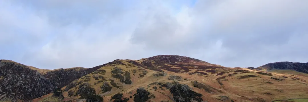
The Mam Tor Ridge Walk is a classic introduction to the dramatic landscapes of the Peak District's Dark Peak area. The route begins with a steady, well-trodden ascent to the summit of Mam Tor (528 metres), a distinctive hill known for its frequent landslides, hence its nickname "Shivering Mountain." From the summit, the views are truly spectacular. To the north, the vast expanse of the Edale Valley unfolds, leading towards the rugged plateau of Kinder Scout. To the south, the Hope Valley stretches out, dotted with villages and framed by the imposing Kinder Edge and the Great Ridge. The air here is often crisp, and on a clear day, the visibility extends for miles, offering a breathtaking panorama of rolling hills, moorland, and distant towns.
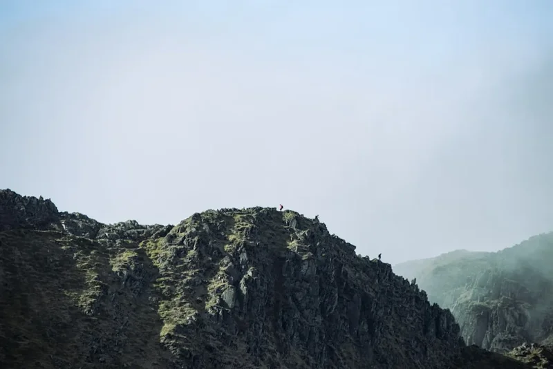
The walk then follows the exposed ridge line, a section of the Pennine Way, which is a popular and exhilarating experience. The path is generally good, though can be uneven and rocky in places. The feeling of being on top of the world, with dramatic drops on either side, is a significant part of the appeal. This section offers constant, evolving views, with the landscape shifting as you progress along the crest.
The descent typically takes you down the western side of Mam Tor, often via the old Roman road, offering a different perspective on the surrounding countryside. This part of the walk can be steeper and more rugged, requiring careful footing. You'll pass through fields and potentially encounter grazing sheep, adding to the rural charm. The route often loops back towards the starting point at Mam Nick, completing a satisfying circuit that combines challenging ascents, exhilarating ridge walking, and a pleasant descent through classic Peak District scenery.
This walk is popular year-round but is particularly rewarding during the spring and summer months when the moorland is vibrant and the weather is generally more favourable. However, its exposed nature means that conditions can change rapidly, and it is advisable to be prepared for all types of weather, even on a seemingly clear day. The moderate difficulty makes it accessible to a wide range of walkers, provided they have a reasonable level of fitness and are comfortable with some steep ascents and descents.
History and Cultural Context
Mam Tor and its surrounding landscape are steeped in history, reflecting centuries of human activity and geological drama. The name "Mam Tor" is derived from the Old English "mamma," meaning mother, and "tor," meaning peak or hill, thus "Mother Hill." Its distinctive shape and prominent position have made it a landmark for millennia.
Evidence of early human settlement is abundant in the area. The summit of Mam Tor itself is crowned by a Bronze Age barrow, and the surrounding hills bear the scars of ancient earthworks and burial sites. The most significant historical feature directly on the ridge is the remains of the Roman road that once connected the lead mining centres of the Peak District with the fortress at Brough (Lactodorum) near modern-day Chapel-en-le-Frith. Sections of this paved road are still visible, particularly on the descent from the western end of the ridge, serving as a tangible link to the Roman occupation of Britain.
The area has also been a focal point for lead mining for centuries. The distinctive spoil heaps and remnants of mine workings are scattered across the landscape, particularly in the Hope Valley. This industry shaped the local economy and the lives of its inhabitants for generations, leaving its mark on the topography and the cultural heritage of the region. The Castleton area, at the foot of Mam Tor, was once a bustling centre for this industry.
Mam Tor's "shivering" nature is due to its geological composition. The hill is composed of alternating layers of shale and limestone. The shale is prone to erosion, and the limestone is soluble, leading to frequent landslips, particularly after periods of heavy rain or frost. The most significant landslide occurred in 1977, which dramatically altered the shape of the hill and led to the closure of the old road that once traversed its summit. This ongoing geological activity is a constant reminder of the dynamic forces at play in the Peak District.
The ridge itself forms part of the Pennine Way, one of Britain's oldest National Trails, established in 1965. This long-distance path traverses the backbone of England, and the section over Mam Tor is one of its most iconic and popular stretches, drawing walkers from across the country and beyond.
Seasonal Highlights and Weather Reality
The Mam Tor Ridge Walk is a year-round destination, but each season offers a distinct experience and presents its own set of challenges.
Spring (April–May): This is a beautiful time to visit. The moorland begins to turn green, and wildflowers start to appear. The weather can be variable, with crisp, sunny days interspersed with rain and wind. The risk of snow on the higher ground diminishes, making the ridge more accessible. The lambing season often means you'll see young sheep in the fields, adding to the charm of the lower sections.
Summer (June–August): The most popular time for walking. Days are longer, and the weather is generally warmer, offering the best chance of clear, panoramic views from the summit and ridge. However, this is also the busiest period, and the car parks can become very crowded, especially on weekends and public holidays. Sandflies can be present, particularly in damper conditions, so insect repellent is advisable. The heather may begin to bloom later in the summer, adding splashes of purple to the landscape.
Autumn (September–October): Autumn brings a spectacular display of colours to the Peak District. The bracken and heather turn shades of gold, russet, and brown, creating a stunning visual spectacle. The air is often clear and crisp, offering excellent visibility. However, the weather can become more unpredictable, with increased chances of rain, fog, and stronger winds. The days are shorter, so starting earlier is recommended.
Winter (November–March): Winter offers a wild and dramatic experience for the more experienced and well-prepared walker. The landscape can be dusted with snow, transforming the familiar hills into a winter wonderland. However, conditions can be harsh, with icy paths, strong winds, and very limited visibility due to fog or low cloud. The ridge can be treacherous, and appropriate winter gear, including ice axe and crampons, may be necessary. The old Roman road section can become particularly slippery. It is essential to check weather forecasts meticulously and be prepared for extreme conditions. The car parks may also be affected by snow.
Weather Reality: Mam Tor is notoriously exposed. The weather can change very rapidly, and it is not uncommon to experience sunshine, rain, wind, and even sleet all within a single walk. Always be prepared for cold and wet conditions, regardless of the season. Layers are key, and waterproofs are essential. The summit and ridge can be significantly colder and windier than the valleys below.
Recommended Itinerary
Mam Tor Ridge Walk - Day Itinerary
Early Morning: Arrival and Ascent Preparation
- Arrive at Mam Nick Car Park (approx. 53.3431, -1.7753). Fees apply.
- Allow time for parking, especially during peak season.
- Check weather conditions and ensure you have appropriate gear.
- Brief yourself on the route and potential hazards.
Morning: Ascent to Mam Tor Summit
- Start the ascent from Mam Nick Car Park.
- The path is well-defined and generally steep, leading directly towards the summit of Mam Tor.
- Distance: Approximately 1.5 km
- Elevation Gain: Approximately 200 m
- Time: 45-60 minutes
- Key Waypoints: The initial steep climb, the summit trig point.
- Enjoy the rapidly expanding views as you gain altitude.
Midday: Ridge Traverse to Hollins Cross
- From Mam Tor summit, follow the clear, paved path along the Great Ridge.
- This section is part of the Pennine Way and offers spectacular, unobstructed views in all directions.
- Distance: Approximately 2.0 km
- Elevation Gain/Loss: Minimal, undulating terrain
- Time: 30-45 minutes
- Key Waypoints: The summit trig point, the exposed ridge path, Hollins Cross (a prominent crossroads with a memorial stone).
- Be mindful of the exposure and wind on this section.
Afternoon: Descent via Old Roman Road
- From Hollins Cross, the path continues along the ridge for a short distance before beginning the descent towards the west.
- Follow signs for the descent route, which often follows the line of the old Roman road.
- Distance: Approximately 3.0 km
- Elevation Loss: Approximately 150 m
- Time: 45-60 minutes
- Key Waypoints: The junction at Hollins Cross, the visible remnants of the Roman road, the descent into the valley.
- The path can be uneven and rocky, requiring careful footing.
Late Afternoon: Return to Mam Nick
- The descent path will lead you back towards the vicinity of Mam Nick.
- Follow the final section of path, which may cross fields or follow minor tracks, to return to the car park.
- Distance: Approximately 1.5 km
- Elevation Gain/Loss: Minor
- Time: 15-20 minutes
- Key Waypoints: The final approach to Mam Nick Car Park.
- Reflect on the stunning views and the invigorating walk.
Important Notes:
- This is a circular route, starting and finishing at Mam Nick Car Park.
- The itinerary is a guideline; adjust timings based on your pace and time spent enjoying the views.
- Always carry water and snacks, even for a short walk.
- Wear sturdy walking boots with good ankle support.
- Be prepared for rapidly changing weather conditions.
Planning and Bookings
Book Your Trip
Everything you need to plan your journey
Accommodation
Find places to stay near Castleton
Flights
Search flights to Castleton
Essential Preparation
The Mam Tor Ridge Walk is a popular destination, and while it doesn't require advance bookings like some national park trails, careful preparation is key to a safe and enjoyable experience. The closest town providing amenities and accommodation is Castleton, a charming village at the foot of Mam Tor. Castleton offers a range of pubs, cafes, shops, and accommodation options, from traditional inns to bed and breakfasts.
Fitness Requirements: The walk is classified as moderate due to the sustained ascent to Mam Tor and the potentially uneven terrain on the ridge and descent. A reasonable level of cardiovascular fitness is required to comfortably manage the 350 metres of elevation gain. Those with knee issues may find the descent challenging. It is advisable to have some experience walking on varied terrain.
Logistics: Access to the trailhead is primarily via the Mam Nick Car Park, located off the A623 road between Castleton and Chapel-en-le-Frith. This car park can become extremely busy, especially on weekends and during peak season. Arriving early in the morning is highly recommended. Alternative parking may be available in Castleton, requiring a longer walk to the start point.
Base Town/City Information: Castleton is the most convenient base. It is well-served by public transport, with bus services connecting it to surrounding towns and cities. Manchester is the nearest major city and international airport, approximately 1.5 hours' drive away. Train services to Castleton are available, often requiring changes, with the nearest main line station being Hope.
Trail Accommodation
This is a day hike requiring no overnight accommodation.
Required Gear
- Sturdy Walking Boots: Waterproof, with good ankle support and well-worn-in to prevent blisters. The terrain can be rocky and uneven.
- Waterproof Jacket: Essential, as weather can change rapidly. Look for breathable, taped-seam options.
- Waterproof Overtrousers: Recommended, especially during wetter months or if rain is forecast.
- Warm Layers: Including a fleece or insulating jacket. Even in summer, the ridge can be cool and windy.
- Hat and Gloves: For warmth and protection against wind, even outside of winter.
- Backpack: A small to medium-sized day pack (20-30 litres) to carry essentials.
- Navigation: While the route is generally well-marked, a map (OS Explorer OL24) and compass are advisable, especially if visibility is poor. A GPS device or smartphone with offline maps is also useful.
- First Aid Kit: Including blister plasters, pain relievers, antiseptic wipes, and any personal medications.
- Sun Protection: Sunscreen, sunglasses, and a sun hat, as the ridge is exposed.
What to Bring
- Food: Plenty of high-energy snacks (e.g., fruit, nuts, energy bars) and a packed lunch. There are no facilities to purchase food on the route itself.
- Water: At least 1-2 litres of water per person. There are no reliable water sources on the ridge itself for refilling.
- Toiletries: Hand sanitiser, any personal hygiene items.
- Mobile Phone: Fully charged, for emergencies. Signal can be intermittent.
- Camera: To capture the stunning panoramic views.
- Walking Poles: Optional, but can be helpful for stability on ascents and descents, especially on rocky or slippery sections.
- Small Trowel and Toilet Paper: If you need to go to the toilet away from designated facilities (though this is a day walk, so less likely). Ensure you follow Leave No Trace principles.
Permits
No permits are required for the Mam Tor Ridge Walk. As it is a public footpath within the Peak District National Park, access is free and open to all. However, parking at Mam Nick Car Park does incur a fee, and spaces can be limited, especially during peak times.
Parking Fees:
- Typically, there is an hourly or daily charge for parking at Mam Nick Car Park. Prices can vary, so it's advisable to check current rates on local signage or the Peak District National Park website.
- Payment is usually via coin, card, or a mobile app.
Alternative Parking:
- If Mam Nick Car Park is full, you can park in Castleton. This will add approximately 1.5-2 km to the overall walk distance, depending on where you park in the village. Castleton also has paid parking facilities.
National Park Access: The Peak District National Park is managed to balance conservation with public access. While no permits are needed for walking, visitors are expected to adhere to the National Park's access codes and principles of responsible enjoyment.
Other Activities in the Area
The area around Mam Tor and Castleton offers a wealth of activities for those looking to extend their visit:
- Explore Castleton Village: Visit the historic Peveril Castle, a Norman fortress with commanding views, explore the village's charming shops, and enjoy traditional pub fare.
- Cave Tours: Castleton is famous for its show caves, including Speedwell Cavern (accessed by boat), Blue John Cavern, and Treak Cliff Cavern, each offering a unique glimpse into the underground world of the Peak District.
- Other Walks: Numerous other walking routes are available, including the full Great Ridge walk to Lose Hill, the Edale Skyline, and various routes exploring Kinder Scout and the surrounding moorlands.
- Cycling: The Peak District offers excellent cycling routes, from scenic road rides to challenging off-road trails.
- Visit Nearby Villages: Explore picturesque villages such as Edale, Hope, and Hathersage, each with its own character and attractions.
- Peak District National Park Visitor Centres: Gain further information on local attractions, walking routes, and conservation efforts.
Safety and Conditions
Weather: The most significant safety consideration is the unpredictable and often harsh weather. Mam Tor and the Great Ridge are very exposed. Always check the Met Office mountain forecast for the Peak District before setting out and be prepared for rapid changes. Hypothermia is a risk, even in summer, if you get wet and cold.
Terrain: The path can be uneven, rocky, and slippery, especially after rain or frost. Sturdy walking boots are essential. The descent can be particularly steep and challenging. Landslides are a natural phenomenon on Mam Tor; while the main paths are generally maintained, be aware of your surroundings and avoid areas that appear unstable.
Navigation: While the route is popular and generally well-signposted, poor visibility due to fog or cloud can make navigation difficult. Carry a map and compass and know how to use them, or use a reliable GPS device with offline maps. Inform someone of your planned route and expected return time.
Exposure: The ridge offers no shelter from the elements. Wind can be extremely strong, making walking difficult and increasing the risk of falls. Ensure you have adequate windproof clothing.
Crowds: Mam Tor is a very popular destination. On busy days, the paths can be crowded, which can slow your progress and may require extra caution when passing others, especially on narrow sections.
Emergency Contacts: In case of emergency, dial 999 or 112 and ask for Mountain Rescue. Be prepared to give your exact location (grid reference if possible) and the nature of the emergency. A personal locator beacon (PLB) or satellite messenger can be a valuable safety tool for remote areas, though signal is generally good on this route.
Livestock: You may encounter sheep grazing on the lower slopes and fields. Keep dogs under close control at all times, and do not disturb the animals.
Side Trips and Points of Interest
Mam Tor Summit: The highest point of the walk at 528 metres. The summit offers a 360-degree panoramic view of the surrounding Peak District landscape. It's an ideal spot for a break, a snack, and to take in the breathtaking scenery. The trig point provides a clear marker for the summit.
The Great Ridge: This is the main feature of the walk, a dramatic, exposed ridge connecting Mam Tor to Lose Hill. Walking along the ridge provides constant, evolving views of the Hope Valley to the south and the Edale Valley to the north. It's a classic section of the Pennine Way and a highlight for many walkers.
Hollins Cross: A significant crossroads on the ridge, marked by a memorial stone. It's a natural point to pause, assess conditions, and decide on the onward route. The views from here are equally impressive.
Old Roman Road: On the descent from the western end of the ridge, you will likely follow sections of the ancient Roman road. The paving stones are still visible in places, offering a tangible connection to the area's history. This section can be uneven and requires careful footing.
Landslip Areas: Mam Tor is famous for its landslides. While the main paths are generally safe, observing the scars on the hillside provides a fascinating insight into the geological forces at play. Be mindful of any unstable ground.
Castleton Village: At the end of the walk (or start), Castleton offers historical interest with Peveril Castle and its show caves, providing a cultural counterpoint to the natural beauty of the ridge walk.
Leave No Trace
The Mam Tor Ridge Walk traverses a beautiful and popular area of the Peak District National Park. To help preserve its natural beauty and ensure an enjoyable experience for all, please adhere to the principles of Leave No Trace:
- Plan Ahead and Prepare: Check weather forecasts, know your route, and pack appropriate gear. Understand the local conditions and any potential hazards.
- Travel and Camp on Durable Surfaces: Stick to the marked paths and trails. Avoid walking on fragile vegetation, especially on the moorland. The paths are designed to withstand foot traffic; straying can cause erosion and damage delicate ecosystems.
- Dispose of Waste Properly: Pack out everything you pack in. This includes all litter, food scraps, and anything else you bring with you. There are no bins on the route. Use the toilet facilities in Castleton or Mam Nick Car Park, or if absolutely necessary, dig a cathole at least 70 metres away from water sources, trails, and campsites, and bury human waste and toilet paper.
- Leave What You Find: Do not remove any natural items, such as rocks, plants, or historical artefacts. Take only photographs and memories.
- Minimise Campfire Impacts: Campfires are not permitted on this day walk. If camping elsewhere in the National Park, use designated fire pits and ensure fires are completely extinguished.
- Respect Wildlife: Observe wildlife from a distance and do not feed any animals, including birds and sheep. Feeding them can harm their health and alter their natural behaviour.
- Be Considerate of Other Visitors: Keep noise levels down, yield to other walkers on narrow paths, and be mindful of others enjoying the scenery.
By following these principles, you help protect the unique environment of the Peak District for future generations.