MacLehose Trail - Hong Kong's Ultimate Ridge Traverse
The MacLehose Trail is the oldest and most iconic long-distance hiking route in Hong Kong, stretching 100 kilometres across the rugged spine of the New Territories. Established in 1979 and named after Sir Murray MacLehose, the longest-serving Governor of Hong Kong and an avid hiker, the trail provides a staggering contrast between one of the world's most densely populated urban centres and its surprisingly wild, mountainous hinterland. The route begins in the east at Pak Tam Chung in Sai Kung and traverses westward through eight country parks—Sai Kung East, Sai Kung West, Ma On Shan, Lion Rock, Kam Shan, Shing Mun, Tai Mo Shan, and Tai Lam—before concluding in the western town of Tuen Mun. This is not merely a walk; it is a journey through volcanic landscapes, over emerald peaks, past ancient Hakka villages, and along some of the most pristine white-sand beaches in Asia. For those who think of Hong Kong only as a concrete jungle, the MacLehose Trail is a profound revelation of the region's natural soul.
- Distance: 100.0 km one-way
- Duration: 8–12 days (can be completed in sections)
- Season: November to April (cooler, drier months are essential for safety)
- Accommodation: Designated AFCD campsites (no huts or lodges on trail)
- Highest point: Tai Mo Shan (957 m)
- Total Elevation Gain: Approximately 4,790 m
- Difficulty: Challenging (requires high fitness and heat management)
- Direction: East to West (Stage 1 to Stage 10)
Overview
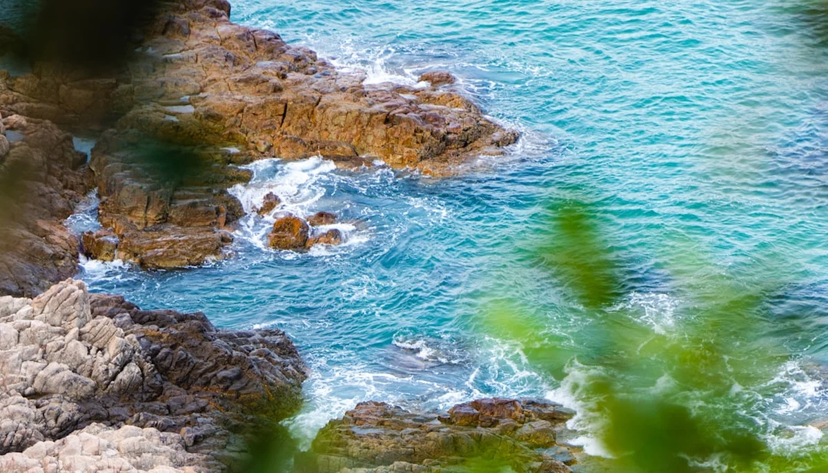
The MacLehose Trail is a masterclass in topographical diversity. It is divided into ten distinct stages, each offering a unique character and varying levels of physical demand. The journey begins with the geological wonders of the High Island Reservoir, where hexagonal volcanic rock columns—part of the UNESCO Global Geopark—tower over the turquoise waters of the South China Sea. As the trail progresses into Stage 2, it drops down to the secluded beaches of Tai Long Wan, widely considered the most beautiful coastal scenery in Hong Kong. Here, the trail feels more like a tropical island paradise than a metropolitan suburb.
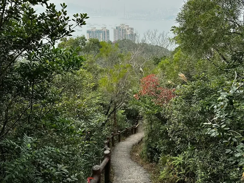
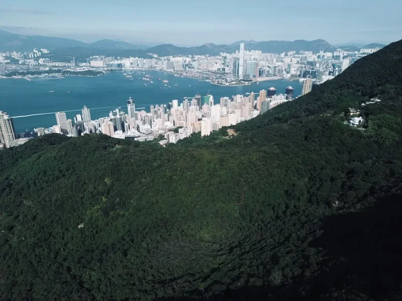
However, the "honeymoon" phase of the coastal sections quickly transitions into the brutal verticality of the central New Territories. Stages 3 and 4 are notorious for their relentless "staircase" climbs, taking hikers over the peaks of Kai Kung Shan and Ma On Shan. The trail then follows the ridgeline of the "Dragon's Back" of the New Territories, offering panoramic views where, on a clear day, the skyscrapers of Kowloon and Hong Kong Island appear like a miniature model city nestled between the mountains and the sea. The sight of the iconic Lion Rock, a symbol of the Hong Kong spirit, provides a cultural touchstone as you traverse the heights above the urban sprawl.
The final third of the trail introduces hikers to the highest point in the territory, Tai Mo Shan. Often shrouded in mist, this dormant volcano offers a sub-tropical alpine experience, with temperatures significantly cooler than the coastal flats. The descent from the high peaks leads into the tranquil reservoirs of Tai Lam, where the terrain softens into forested paths and catch-waters, providing a meditative conclusion to a physically gruelling odyssey. The MacLehose Trail is a test of endurance, but more importantly, it is a testament to Hong Kong's successful "Green City" initiative, which has preserved 40% of the territory's land as protected country parks.
History and Cultural Context
The MacLehose Trail was officially opened on 26 October 1979, marking a pivotal moment in Hong Kong's environmental history. During the 1970s, as Hong Kong underwent rapid industrialisation and urban expansion, Sir Murray MacLehose recognised the need for recreational spaces to support the mental and physical well-being of the population. His vision led to the enactment of the Country Parks Ordinance in 1976, and the MacLehose Trail was designed as the flagship project to connect these newly protected areas. The trail was largely constructed by the British Army and the Royal Hong Kong Regiment, with many sections following ancient footpaths that had connected Hakka villages for centuries.
Culturally, the trail passes through landscapes that tell the story of Hong Kong's rural past. In the Sai Kung and Tai Lam sections, hikers will encounter the ruins of abandoned villages, ancestral graves, and "fung shui" woods—groves of native trees planted behind villages to bring good fortune and protect against landslides. These areas were once thriving agricultural communities growing rice, tea, and pineapples. The Japanese occupation during World War II left its mark as well; Stage 6 traverses the Gin Drinker's Line, a British defensive fortification system consisting of bunkers and trenches designed to stall the Japanese advance in 1941. Walking the MacLehose is, therefore, a walk through the layers of Hong Kong's military, social, and geological history.
In recent decades, the trail has gained international fame through the Trailwalker event, an annual charity mountain marathon where teams of four attempt to complete the entire 100 km in under 48 hours. This event has transformed the MacLehose from a recreational path into a legendary proving ground for endurance athletes. Despite its proximity to the city, the trail remains a place of profound quietude, where the only sounds are the call of the Black Kite or the rustle of macaques in the canopy.
Want more background? Read extended notes on history and cultural context → Learn more
Seasonal Highlights and Weather Reality
The climate of Hong Kong is the single most important factor in planning a MacLehose traverse. Unlike temperate trails, the primary danger here is not cold, but extreme heat and humidity. The "hiking season" is strictly defined by the arrival of the northeast monsoon, which brings cooler, drier air to the region.
Autumn (November to December): This is the goldilocks zone for the MacLehose Trail. The humidity drops, the skies are often a brilliant "Hong Kong blue," and temperatures range from 18°C to 24°C. This is the best time for long-distance trekking, as the risk of heatstroke is minimised and the views from the ridgelines are at their clearest.
Winter (January to February): While Hong Kong never experiences true alpine winter, the high ridges of Tai Mo Shan can drop to 0°C or lower during cold surges. Frost is rare but possible. These months are excellent for hiking, though the landscape can appear somewhat brown and dormant. Hikers should be prepared for sudden temperature drops when the sun sets.
Spring (March to April): The humidity begins to rise, and sea fogs often roll in, shrouding the coastal stages in a mystical, damp mist. While the temperatures are still pleasant (20°C to 26°C), the trails can become slippery, and the views from the peaks are often obscured by clouds. This is the season when the native azaleas and Bauhinia trees bloom, adding splashes of colour to the hillsides.
Summer (May to October): Hiking the full MacLehose Trail in summer is strongly discouraged for all but the most elite, heat-acclimatised athletes. Temperatures regularly exceed 32°C with humidity levels above 90%, creating a "feels like" temperature of over 40°C. Tropical cyclones (typhoons) and heavy monsoon rains are frequent, leading to landslides and flash floods. If hiking during this time, limit activity to early morning or late afternoon and carry double the usual amount of water.
Recommended Itinerary
8-Day MacLehose Trail Itinerary
Day 1: Pak Tam Chung to Long Ke (Stage 1)
- Distance: 10.6 km
- Elevation gain: 200 m
- Time: 3–4 hours
- Start at Pak Tam Chung Visitor Centre (accessible by bus/taxi)
- Walk along the paved road bordering High Island Reservoir
- View the East Dam's hexagonal volcanic rock columns (UNESCO Geopark)
- Arrive at Long Ke Wan, a stunning white-sand beach
- Camp at Long Ke Campsite (basic facilities, no treated water)
- A gentle introduction on paved surfaces with world-class geological views
Day 2: Long Ke to Pak Tam Au (Stage 2)
- Distance: 13.5 km
- Elevation gain: 650 m
- Time: 5–6 hours
- Climb over Sai Wan Shan for the first major ascent
- Descend to the four beaches of Tai Long Wan (Sai Wan, Ham Tin, Tai Wan, Tung Wan)
- Pass through the village of Ham Tin (small cafes available for lunch)
- Steep climb out of the valley towards Pak Tam Au
- Camp at Pak Tam Au or take a bus to nearby accommodation
- The most scenic coastal day, featuring crystal clear waters and steep headlands
Day 3: Pak Tam Au to Kei Ling Ha (Stage 3)
- Distance: 10.2 km
- Elevation gain: 600 m
- Time: 4–5 hours
- Relentless "up and down" terrain over four peaks, including Kai Kung Shan
- Dense woodland sections alternating with exposed ridges
- Views over Tolo Harbour and the Plover Cove Reservoir
- Finish at Kei Ling Ha (Shui Long Wo) on the Sai Sha Road
- Campsites available at Shui Long Wo
- Physically demanding due to the steep, uneven stone steps
Day 4: Kei Ling Ha to Gilwell Camp (Stage 4)
- Distance: 12.7 km
- Elevation gain: 700 m
- Time: 5–6 hours
- Long ascent onto the Ma On Shan ridgeline
- Traverse the spectacular "broken-back" ridge of Ngong Ping plateau
- Views of the pyramid-shaped Ma On Shan peak (optional side scramble)
- Pass through bamboo groves and high-altitude grasslands
- Arrive at Gilwell Camp (private campsite, check availability) or nearby Ngong Ping campsite
- High-altitude ridge walking with some of the best inland views in Hong Kong
Day 5: Gilwell Camp to Beacon Hill (Stage 5)
- Distance: 10.6 km
- Elevation gain: 450 m
- Time: 3–4 hours
- Follow the ridgeline directly above the Kowloon Peninsula
- Pass the iconic Lion Rock (steep side path to the summit is highly recommended)
- Traverse Amah Rock, a natural stone formation resembling a woman carrying a child
- Views of the Kai Tak Cruise Terminal and the dense urban grid of Mong Kok
- Finish near the Eagle's Nest Nature Trail
- A cultural and urban-visual highlight of the trek
Day 6: Beacon Hill to Shing Mun (Stages 6 & 7)
- Distance: 10.8 km
- Elevation gain: 550 m
- Time: 4–5 hours
- Stage 6: Walk through Kam Shan Country Park, famous for its large macaque population
- Pass the WWII bunkers of the Gin Drinker's Line at Smuggler's Ridge
- Stage 7: Steep climb up Needle Hill (sharp, conical peak)
- Traverse Grassy Hill with views over Sha Tin
- Descend to the Shing Mun Reservoir (Lead Mine Pass)
- Camp at Lead Mine Pass Campsite
Day 7: Shing Mun to Route Twisk (Stage 8)
- Distance: 9.7 km
- Elevation gain: 600 m
- Time: 4 hours
- The "Big Mountain" day: ascending Tai Mo Shan, Hong Kong's highest peak
- Follow a winding access road and stone paths through sub-tropical grasslands
- Pass the weather radar station at the summit (957 m)
- Descend through the mist-prone western slopes
- Finish at the Route Twisk road crossing
- Cooler temperatures and expansive views across the western New Territories
Day 8: Route Twisk to Tuen Mun (Stages 9 & 10)
- Distance: 21.9 km
- Elevation gain: 300 m
- Time: 6–7 hours
- Stage 9: Forested paths through Tai Lam Country Park
- Stage 10: Long, flat section following the Tai Lam Catch-water
- Pass the "Thousand Islands" viewpoint over Tai Lam Chung Reservoir
- Final descent into the urban outskirts of Tuen Mun
- Finish at the MTR station for easy transport back to the city
- A long but physically easier day to conclude the 100 km journey
Planning and Bookings
Book Your Trip
Everything you need to plan your journey
Accommodation
Find places to stay near Hong Kong
Flights
Search flights to Hong Kong
Essential Preparation
The MacLehose Trail requires significant logistical planning, primarily because it is a linear route that crosses multiple transport hubs. Unlike European or North American trails, you are never more than a few kilometres from a road, but those roads may only be served by infrequent minibuses or expensive taxis. It is essential to have an Octopus Card (Hong Kong's universal transport card) topped up with at least HK$500 for transport and supplies.
Fitness preparation should focus on "stair climbing." The MacLehose is famous for its thousands of stone steps, which are often uneven and high. Training on a StairMaster or local stadium steps is highly recommended. Additionally, hikers must be comfortable with self-navigation; while the trail is well-marked with distance posts every 500 metres (M001 to M200), the intersections with other trails can be confusing.
Trail Accommodation
There are no mountain huts, lodges, or hotels directly on the MacLehose Trail. Accommodation is limited to designated government campsites managed by the Agriculture, Fisheries and Conservation Department (AFCD).
Campsite Facilities:
- Most campsites are free of charge and operate on a first-come, first-served basis. No booking is required.
- Facilities are basic: usually a flat dirt or grass area, wooden picnic tables, and pit toilets (dry latrines).
- Water: Most campsites do not have treated tap water. Hikers must collect water from nearby streams and treat it (boiling or filtration) or carry sufficient water from the previous stage.
- Fires: Only allowed in designated BBQ pits. Gathering wood from the forest is illegal; you must bring your own charcoal or use a gas stove.
Alternative Accommodation: Many hikers choose to "section hike" the trail, returning to a hotel or hostel in the city each night via public transport. This allows for a hot shower and a bed but removes the "wilderness" experience of the trek.
Required Gear
- Hiking boots or trail runners: Must have excellent grip for wet stone steps. Trail runners are popular due to the high percentage of paved/hard surfaces.
- Lightweight backpack: 35–50L for those camping; 15–25L for section hikers.
- Navigation: A physical map (Countryside Map: New Territories East & West) and a GPS app with offline maps (e.g., TrailWatch or AllTrails).
- Sun protection: A wide-brimmed hat, high-SPF sunscreen, and UV-rated clothing. The ridges are almost entirely exposed.
- Rain gear: A lightweight, breathable waterproof shell. Umbrellas are surprisingly effective on the paved sections of the trail.
- First aid kit: Must include blister pads (moleskin), electrolyte salts, and antiseptic for small scratches from thorny vegetation.
What to Bring
- Water: Minimum 3 litres per day. In warmer weather, 4–5 litres may be necessary.
- Water treatment: A high-quality filter (e.g., Sawyer Squeeze) or purification tablets.
- Food: High-calorie, lightweight snacks (nuts, dried fruit, energy bars). While there are small village stores in Stages 2, 4, and 9, they have irregular opening hours.
- Octopus Card: Essential for buses, minibuses, and buying drinks at vending machines or village stores.
- Power bank: To keep your phone charged for navigation and emergency calls.
- Insect repellent: Essential for protection against mosquitoes and biting midges (sandflies) in the forested valleys.
Permits
One of the greatest advantages of the MacLehose Trail is its accessibility. No permits are required to walk the trail, and there are no entry fees for the Country Parks. You can simply show up at the trailhead and begin walking.
Camping Regulations:
- Wild camping (camping outside of designated AFCD campsites) is strictly prohibited in Hong Kong Country Parks. Offenders can be fined up to HK$2,000.
- During peak periods (public holidays and weekends), popular campsites like Long Ke or Ngong Ping can become very crowded. Arrive early to secure a spot.
- Group permits: If you are organising a group event or a race with more than 30 people, you must apply for a "Controlled Group Activity" permit from the AFCD at least four weeks in advance.
Transport Permits: Some trailheads, particularly Pak Tam Chung (the start of Stage 1), are located within restricted zones. Private cars without a "Lantau/Sai Kung Closed Road Permit" cannot enter. Hikers should rely on taxis or public buses (No. 94 or 96R) to reach the start point.
Other Activities in the Area
If you have extra time in the New Territories, consider these nearby attractions:
- Sharp Peak (Lau Fa Shan): Located near Stage 2, this is considered the most challenging "unofficial" climb in Hong Kong. The views from the summit are the best in the territory.
- Hong Kong UNESCO Global Geopark: Take a boat tour from Sai Kung town to see the sea sea caves and hexagonal columns from the water.
- Tai O Fishing Village: Located on Lantau Island, this "Venice of the East" features traditional stilt houses and a glimpse into the pre-colonial lifestyle.
- Ten Thousand Buddhas Monastery: Located in Sha Tin (near Stage 7), this temple features over 12,000 gold-painted Buddha statues lining the steep path to the complex.
- Kadoorie Farm and Botanic Garden: Situated on the slopes of Tai Mo Shan, this conservation centre offers beautiful gardens and wildlife exhibits (including rescued leopard cats and owls).
Safety and Conditions
Heat and Hydration: Heatstroke is the leading cause of emergency rescues on the MacLehose Trail. The combination of high humidity and steep climbs prevents the body from cooling effectively. Hikers must drink before they feel thirsty and supplement water with electrolytes. If you stop sweating or feel dizzy, find shade immediately and stop moving.
Wildlife Encounters:
- Macaques: Found primarily in Stages 5 and 6. They are habituated to humans and will aggressively steal food. Never eat in front of them, keep all food inside your pack, and do not make eye contact.
- Wild Boars: Common throughout the trail. They are generally shy but can be dangerous if cornered or if they have piglets. Give them a wide berth.
- Snakes: Hong Kong is home to several venomous species, including the Bamboo Pit Viper and the King Cobra. Stay on the path, watch where you step, and never put your hands into thick brush.
- Feral Dogs: Occasionally found near abandoned villages. Most are timid, but walking with a trekking pole can provide a deterrent if they become territorial.
Emergency Services: The emergency number in Hong Kong is 999. Most of the trail has mobile phone coverage, but there are "dead zones" in the deep valleys of Sai Kung and Tai Lam. Distance posts (M001–M200) are the most accurate way to describe your location to rescuers. If you are in a dead zone, look for the emergency emergency telephones located at major trail intersections.
Flash Floods: During the rainy season, stream crossings in Stages 2 and 3 can become extremely dangerous. Never attempt to cross a swollen stream after heavy rain; wait for the water level to drop, which usually happens within a few hours of the rain stopping.
Side Trips and Points of Interest
Lion Rock Summit: While the MacLehose Trail passes just below the peak, the 15-minute scramble to the "head" of the lion is essential. It offers a vertical drop-off view of the entire Kowloon peninsula and is the ultimate spot for a sunset photograph.
The Gin Drinker's Line (Stage 6): Take time to explore the "Shing Mun Redoubt." This is a network of tunnels and observation posts built by the British in the 1930s. Bring a head torch to explore the tunnels, which are still named after London streets like "Oxford Street" and "Regent Street."
Tai Long Wan Sea Caves: At the northern end of Tai Wan beach (Stage 2), there are several sea caves accessible at low tide. The rock formations here are spectacular, but be wary of the incoming tide and rogue waves.
Ngong Ping Plateau: This high-altitude meadow in Stage 4 is one of the few places in Hong Kong where you can see paragliders taking off. It is a perfect spot for a long lunch break with views of the Sai Kung islands.
Leave No Trace
Hong Kong's Country Parks face immense pressure from the millions of visitors they receive annually. The "Take Your Litter Home" policy is strictly enforced, and many bins have been removed from the trails to prevent wild animals from scavenging.
Core Principles for the MacLehose:
- Pack it in, pack it out: This includes fruit peels and tissues. The humid environment means "biodegradable" items take much longer to decompose than you might expect.
- Respect the silence: Avoid using Bluetooth speakers. The sound of the city is never far away; let the trail be a place of quiet.
- Stay on the stone: Many sections of the trail are heavily eroded. Walking on the vegetation beside the path widens the scar and leads to further landslides.
- Do not feed the animals: Feeding monkeys or boars changes their natural behaviour and makes them a danger to future hikers.
- Water protection: Do not use soap or shampoo in the streams or reservoirs. These are vital sources of drinking water for the city.