Lycian Way (Coastal Sections) - Turkey’s Turquoise Trek
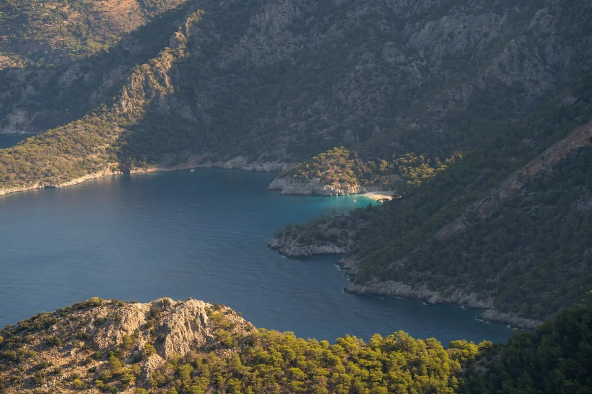
The Lycian Way, or Likya Yolu, is Turkey’s first long-distance trekking route, stretching approximately 540 kilometres along the ancient coast of Lycia. While the full trail winds from Fethiye to Antalya, the coastal sections are world-renowned for their dramatic juxtaposition of rugged limestone crags and the shimmering turquoise waters of the Mediterranean Sea. This journey is not merely a physical challenge; it is a walk through a living museum. The path follows ancient Roman roads, nomadic migration routes, and mule paths that have connected secluded mountain villages for millennia. Walkers traverse a landscape dotted with the ruins of the Lycian League—the world’s first democratic union—where rock-cut tombs, massive amphitheatres, and sunken cities emerge from the scrubland like ghosts of a forgotten empire. The coastal sections offer the most iconic vistas, leading hikers through fragrant pine forests, olive groves, and over high ridges that drop precipitously into secluded coves accessible only by foot or boat.
- Distance: 540.0 km (Full trail); Coastal highlights approx. 120–150 km
- Duration: 25–35 days (Full trail); 8–12 days for major coastal sections
- Season: Spring (April–May) and Autumn (September–October)
- Accommodation: Village pensions (pansiyons), wild camping, and small hotels
- Highest point: Mount Olympos (Tahtalı Dağı) at 2,366 m (on the full route)
- Difficulty: Moderate (rugged terrain, significant elevation changes, and heat management)
- Direction: Generally walked West to East (Fethiye to Antalya)
Overview
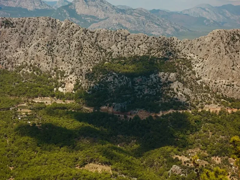
The Lycian Way was researched and waymarked in 1999 by Kate Clow, a British expatriate who sought to preserve the ancient footpaths of the Tekke Peninsula. Since then, it has gained a reputation as one of the world’s top ten long-distance walks. The coastal sections are particularly beloved for their sensory richness. As you walk, the air is thick with the scent of wild thyme, sage, and pine resin. The terrain is characteristically Mediterranean: sharp limestone rocks, "maquis" shrubland, and ancient stone-paved paths that test your ankles but reward you with views of the "Turquoise Coast" that are nothing short of cinematic.
Unlike many European trails that stay high in the mountains or low on the coast, the Lycian Way is a constant vertical zig-zag. You might start your morning at sea level, swimming in the crystal-clear waters of a deserted bay, only to spend the afternoon climbing 600 metres to a ridge-top village where life has changed little in a century. This rhythm provides a unique cultural immersion. You will encounter local shepherds tending goats, see women weaving traditional carpets, and likely be invited for "çay" (tea) in a village square. The hospitality of the Turkish people is a cornerstone of the Lycian Way experience, often turning a simple hike into a series of warm human encounters.
The coastal sections focus on the western and central parts of the trail, including the famous Butterfly Valley, the 12-kilometre sands of Patara Beach, and the sunken ruins of Kekova. While the full 540-kilometre trek is a monumental undertaking, most walkers choose to tackle the coastal highlights over one or two weeks. The infrastructure is well-developed in these areas, with "pansiyons" (guesthouses) providing comfortable beds and home-cooked Turkish meals, making it accessible to those who prefer not to carry heavy camping gear. However, the trail remains rugged and demanding; the "moderate" rating reflects the rocky nature of the path and the intense Mediterranean sun, which can be punishing even in the shoulder seasons.
History and Cultural Context
The trail takes its name from the Lycians, a fiercely independent people who inhabited this peninsula from the Bronze Age through the Roman period. The Lycian League was a sophisticated confederation of city-states, praised by Montesquieu as the earliest example of a democratic union. Their legacy is etched into the landscape. Unlike the Greeks or Romans who built their necropolises outside city walls, the Lycians integrated their dead into the living landscape. As you walk, you will encounter "sarcophagi" (stone coffins) standing in the middle of fields or perched on cliff edges, and "rock-cut tombs" carved directly into the faces of mountains, designed to resemble the wooden houses of the living.
Key historical sites along the coastal sections include Patara, the capital of the Lycian League and the birthplace of St Nicholas; Xanthos, a UNESCO World Heritage site famous for its tragic history of resistance against Persian and Roman invaders; and the "Sunken City" of Simena, where ancient foundations are visible beneath the clear waters of the Mediterranean. The trail also follows sections of the Roman road network, where the original stone paving is still visible, worn smooth by centuries of travel. Walking here is a lesson in layers of history—Lycian, Greek, Roman, Byzantine, and Ottoman influences are all visible, often within the same square kilometre.
The cultural context extends to the modern day. The trail passes through many "Yörük" (nomadic) areas. While many of these communities have settled into permanent villages, the tradition of seasonal migration to high-altitude pastures ("yaylas") remains. The stone cisterns you see along the trail, many still in use, were built to collect rainwater for livestock in this arid landscape. Understanding this history of water scarcity and nomadic resilience adds a profound layer of respect for the environment you are traversing.
Want more background? Read extended notes on history and cultural context → Learn more
Seasonal Highlights and Weather Reality
Timing is the most critical factor when planning the Lycian Way. The Mediterranean climate creates a narrow window of ideal trekking conditions. Summer (June to August) is dangerously hot, with temperatures frequently exceeding 40°C. The humidity on the coast can make physical exertion nearly impossible, and many water sources dry up completely. Trekking during this period is strongly discouraged.
Spring (April to May): This is arguably the best time to walk. The landscape is a riot of colour as wildflowers, including rare orchids and anemones, carpet the hillsides. The weather is generally mild (18–25°C), and the days are long. The snow is melting on the higher peaks of the Taurus Mountains, ensuring that springs and cisterns are full. However, the sea may still be a bit brisk for swimming early in April.
Autumn (September to October): This is the second peak season. The intense heat of summer has faded, but the Mediterranean Sea remains warm and perfect for swimming. The harvest season brings fresh pomegranates, grapes, and figs to the village tables. The air is often clearer than in spring, providing spectacular views across to the Greek islands. By late October, the risk of rain increases, and the days begin to shorten significantly.
Winter (November to March): While the coastal sections remain relatively mild, the higher sections of the trail can experience snow and freezing temperatures. Many guesthouses in smaller villages close for the winter, and the days are short and often rainy. For an experienced, self-sufficient trekker, a winter walk on the lower coastal sections can be peaceful, but it requires careful planning regarding accommodation and supplies.
Recommended Itinerary
10-Day Coastal Highlights Itinerary (Fethiye to Kaş)
Day 1: Fethiye to Kayaköy
- Distance: 9 km
- Elevation gain: 350 m
- Time: 3–4 hours
- Start at the official trailhead in Fethiye (near the rock tombs)
- Climb through pine forests with views over Fethiye bay
- Descend into the "Ghost Village" of Kayaköy, abandoned during the 1923 population exchange
- Explore the hundreds of roofless stone houses and two large Greek Orthodox churches
- Stay in a local pension in the valley
Day 2: Kayaköy to Ölüdeniz
- Distance: 6 km
- Elevation gain: 200 m
- Time: 2–3 hours
- A short but spectacular day
- The trail winds around the hillside with constant views of the turquoise Blue Lagoon
- Steep descent into the resort town of Ölüdeniz
- Afternoon spent swimming or watching paragliders land on the beach
- Note: This is a popular day-hike section and can be busy
Day 3: Ölüdeniz to Faralya
- Distance: 14 km
- Elevation gain: 650 m
- Time: 5–6 hours
- The "real" Lycian Way begins with a steady climb up the slopes of Baba Dağı (Father Mountain)
- Incredible views back toward the lagoon and the Seven Capes
- Pass through the village of Kozağaç
- Arrive in Faralya, perched on the cliffs above Butterfly Valley (Kelebekler Vadisi)
- Stay in a cliffside guesthouse with sunset views
Day 4: Faralya to Kabak
- Distance: 8 km
- Elevation gain: 300 m
- Time: 3–4 hours
- The trail follows the cliff edge before descending into the lush Kabak Valley
- Kabak is a bohemian retreat with many eco-camps and wooden cabins
- Option to descend all the way to Kabak beach for a swim
- The climb back up to the village is steep but short
Day 5: Kabak to Alınca
- Distance: 13 km
- Elevation gain: 800 m
- Time: 6–7 hours
- One of the most challenging and rewarding days
- A long, steady climb out of the Kabak Valley
- The trail traverses high ridges with dramatic "Seven Capes" views
- Arrive in the mountain village of Alınca, which feels like an eagle's nest overlooking the sea
- Limited accommodation; booking ahead is essential
Day 6: Alınca to Gey (via Yediburunlar)
- Distance: 11 km
- Elevation gain: 400 m
- Time: 4–5 hours
- The path follows the contours of the mountainside
- Pass through ancient olive groves and past stone cisterns
- Spectacular views of the "Seven Capes" (Yediburunlar) coastline
- Arrive in the traditional village of Gey (officially named Yediburunlar)
- Experience authentic village hospitality in a local home-stay
Day 7: Gey to Patara (via Bel and Gavurağılı)
- Distance: 18 km
- Elevation gain: 300 m gain, 800 m descent
- Time: 7–8 hours
- A long day with a significant descent
- Pass through the village of Bel and descend a rocky, zig-zagging path to Gavurağılı
- Continue toward the ruins of Pydnai and the western end of Patara Beach
- Transfer or walk to the village of Gelemiş (the base for Patara ruins)
Day 8: Patara to Kalkan
- Distance: 15 km
- Elevation gain: 450 m
- Time: 5–6 hours
- Morning exploring the vast ruins of Patara (theatre, parliament building, lighthouse)
- The trail follows the ancient Roman aqueduct (Delikkemer)
- See the incredible "inverted siphon" engineering of the aqueduct
- Descend into the sophisticated harbour town of Kalkan
Day 9: Kalkan to Sarıbelen
- Distance: 13 km
- Elevation gain: 700 m
- Time: 5–6 hours
- A steep climb out of Kalkan onto the high plateau
- The landscape changes to more rugged, rocky terrain
- Views back over the Kalkan bay and the islands
- Arrive in the quiet village of Sarıbelen
Day 10: Sarıbelen to Kaş
- Distance: 16 km
- Elevation gain: 300 m gain, 800 m descent
- Time: 6–7 hours
- The final stretch into the vibrant town of Kaş
- Pass through the ruins of Phellos, situated on a high ridge with incredible sarcophagi
- A long, rocky descent with views of Meis (the Greek island of Kastellorizo)
- Finish in Kaş, the perfect place for a celebratory meal and a boat trip
Important Notes:
- Waymarking uses the international Grande Randonnée (GR) style: red and white stripes
- Water is scarce; always carry at least 3 litres, especially on the Alınca and Gey sections
- The terrain is very rocky; trekking poles are highly recommended to save your knees
- Village guesthouses usually include breakfast and dinner (half-board)
Planning and Bookings
Book Your Trip
Everything you need to plan your journey
Accommodation
Find places to stay near Fethiye
Flights
Search flights to Fethiye
Essential Preparation
The Lycian Way requires a moderate level of fitness and, more importantly, a high tolerance for rocky, uneven terrain. Preparation should focus on leg strength and balance. If you are not used to walking on loose limestone, practice on similar terrain before arriving. Logistically, the trail is best accessed via Dalaman Airport (DLM) for the western sections or Antalya Airport (AYT) for the eastern sections. Fethiye is the primary base town for the coastal start; it has excellent supermarkets, outdoor shops, and transport links.
Booking coordination is relatively straightforward compared to New Zealand’s Great Walks, but during the peak months of April and October, the popular village pensions can fill up. It is advisable to book your first few nights and any particularly small villages (like Alınca or Gey) in advance. Most village hosts speak basic English or can be reached via WhatsApp or booking platforms.
Trail Accommodation
Accommodation on the Lycian Way is a highlight of the experience, offering a mix of comfort and cultural immersion. There are three main types of stay:
Pansiyons (Guesthouses): These are common in almost every village. They are usually family-run and offer clean, basic rooms with private or shared bathrooms.
- Facilities: Hot showers, comfortable beds, and incredible home-cooked meals (usually "meze" starters, a main meat or vegetable dish, and fruit).
- Costs: Typically 1,200–2,000 Turkish Lira per person per night, including breakfast and dinner.
- Availability: Open March to November; some close in the deep winter.
Village Houses: In smaller villages like Gey or Alınca, you may stay in a spare room of a family home. This is the most authentic experience. Facilities are basic, and you will eat with the family. No booking platforms exist for these; you simply arrive and ask for "konaklama" (accommodation).
Wild Camping: Camping is permitted along most of the trail. There are many beautiful spots near ruins or on cliff edges.
- Requirements: You must be self-sufficient with a stove and water filtration.
- Restrictions: Strictly no fires during the dry season (May–October) due to extreme wildfire risk.
- Facilities: None. You must follow Leave No Trace principles meticulously.
Required Gear
- Trekking Boots: Essential. The limestone is sharp and the paths are often loose scree. You need stiff soles and good ankle support.
- Trekking Poles: Highly recommended for the steep descents and to help with balance on rocky sections.
- Navigation: A dedicated GPS app (like the official Culture Routes Society app or Komoot) is essential. While waymarked, the red/white stripes can be faded or confusing at junctions.
- Sun Protection: A wide-brimmed hat, high-SPF sunscreen, and UV-rated sunglasses. The Mediterranean sun is intense.
- Backpack: 35–45L for pension-to-pension walking; 55–65L if carrying camping gear.
- First Aid: Blister kits (Compeed), antiseptic wipes, and rehydration salts (essential for heat management).
What to Bring
- Water Capacity: Ability to carry at least 3–4 litres of water. Many sections have no reliable water sources between villages.
- Cash: Turkish Lira in small denominations. Many village pensions do not accept credit cards, and ATMs are only found in larger towns like Fethiye, Kalkan, and Kaş.
- Power Bank: To keep your phone/GPS charged, as you will rely on it for navigation.
- Swimwear: You will pass some of the world's most beautiful beaches; a lightweight travel towel is also useful.
- Modest Clothing: While shorts are fine for hiking, bring a lightweight pair of trousers or a long skirt for visiting mosques or more traditional inland villages.
- Snacks: High-energy snacks like nuts, dried figs, and apricots (easily bought in local markets).
Permits
One of the great advantages of the Lycian Way is that no permits or fees are required to walk the trail itself. It is a public right-of-way. However, there are several logistical "permits" and costs to consider for a smooth journey.
Museum Pass Mediterranean: While the trail is free, many of the ancient cities it passes through (such as Patara, Xanthos, and Myra) are protected archaeological sites with entry fees. If you plan to visit several, purchasing a "Museum Pass Mediterranean" or a "Museum Pass Turkey" is highly cost-effective. These can be bought at the entrance of any major site and are valid for 15 days.
Visa Requirements: Most international visitors require an e-Visa to enter Turkey. This should be organised online at least a week before travel. Check the latest requirements for your specific nationality on the official Turkish government website.
Camping "Permits": While wild camping is generally free and legal, some specific areas (like the immediate vicinity of major archaeological sites or certain private beaches) may prohibit camping. Always look for signs or ask locals if you are unsure. In Butterfly Valley and Kabak, there are designated campsites that charge a small fee (approx. 400–600 Lira) for use of their facilities (showers/toilets).
Transport Logistics: No permits are needed for the local "dolmuş" (minibuses), which are the backbone of Turkish rural transport. They run frequently between major towns and trailheads. Simply wait by the side of the road and wave them down.
Other Activities in the Area
The Lycian coast is a world-class tourism destination, and it is worth building in extra days to experience the following:
- Paragliding in Ölüdeniz: Launch from the 1,960-metre summit of Baba Dağı and glide over the Blue Lagoon. It is one of the most famous paragliding spots in the world.
- Kekova Boat Trip: Take a "Gulet" (traditional wooden boat) from Kaş or Üçağız to see the Sunken City of Simena. You can swim in turquoise bays and see Lycian sarcophagi half-submerged in the water.
- Scuba Diving in Kaş: Kaş is the diving capital of Turkey, offering clear water, underwater caves, and even a submerged C-47 Dakota airplane wreck.
- Sea Kayaking over the Sunken City: For a more active perspective, paddle a kayak over the ruins of Simena for a close-up view of the ancient foundations.
- Turkish Bath (Hamam): After a week of trekking, there is no better way to recover than a traditional scrub and massage in a historic hamam in Fethiye or Kaş.
- Meis Island Trip: Take the 20-minute ferry from Kaş to the Greek island of Meis (Kastellorizo) for a day of Greek food and a visit to the stunning Blue Grotto.
Safety and Conditions
Heat and Hydration: The single greatest danger on the Lycian Way is heatstroke and dehydration. Even in April and October, temperatures can reach 30°C. Many sections of the trail are exposed with no shade. You must carry more water than you think you need. Learn the locations of "çeşme" (taps) and "sarnıç" (cisterns), but always treat cistern water with purification tablets or a filter.
Terrain and Footwear: The trail is notoriously "ankle-breaking." The limestone is sharp, and the path often consists of loose, rolling stones. Sturdy boots with a vibram-style sole are non-negotiable. Trekking poles are essential for stability, especially when carrying a heavy pack on steep descents.
Waymarking and Navigation: While the trail is marked with red and white stripes, these can be obscured by new construction, goat paths, or fading. Never rely solely on the markers. Always have a GPS-enabled map on your phone and a backup power bank. If you haven't seen a marker for 200 metres, backtrack to the last one you saw.
Wildlife: Scorpions and snakes (including the Ottoman Viper) exist but are rarely seen. They are generally shy and will move away if they hear you coming. Always check your boots before putting them on if you are camping, and avoid sticking your hands into dark rock crevices. Wild boars are common but nocturnal and harmless if left alone. The most common "wildlife" encounter is with large shepherd dogs (Kangal or Akbash). These dogs are protective of their flocks. If you encounter one, do not run. Walk slowly, keep your distance, and if necessary, pick up a stone (or pretend to)—the dogs understand this gesture and will usually back off.
Emergency Services: The emergency number in Turkey is 112. However, mobile signal can be spotty in deep canyons or remote ridges. It is highly recommended to have travel insurance that covers mountain rescue and to let your guesthouse host know your intended destination for the day.
Side Trips and Points of Interest
Butterfly Valley (Kelebekler Vadisi): A stunning canyon with 350-metre high walls that open onto a white sand beach. While the descent from the Lycian Way is extremely steep and involves fixed ropes (not recommended for those with heavy packs or a fear of heights), most hikers view it from the cliffs of Faralya or take a boat from Ölüdeniz. In spring, the valley is home to the Jersey Tiger moth.
The Delikkemer Aqueduct: Located between Patara and Kalkan, this is a masterpiece of Roman engineering. It features an "inverted siphon" made of massive stone blocks with a hole bored through the centre, designed to move water across a deep valley using pressure. Walking across the top of the aqueduct is a highlight for history buffs.
Phellos: An ancient Lycian city located on a high ridge above Kaş. It is rarely visited by tourists and offers some of the most atmospheric ruins on the trail. The sarcophagi here, perched on the edge of the ridge with views of the sea and mountains, are hauntingly beautiful and provide a sense of the "romantic" archaeology of the 19th century.
St Nicholas Island (Gemiler Adası): Visible from the trail near Kayaköy, this island contains the ruins of five Byzantine churches. It is believed by some to be the original burial place of St Nicholas (Santa Claus). You can visit the island by boat from Ölüdeniz or Kayaköy beach.
Leave No Trace
The Lycian Way passes through fragile ecosystems and ancient archaeological sites. As visitor numbers increase, the impact on the trail is becoming more visible. It is the responsibility of every trekker to preserve this unique heritage.
Fire Safety: This is the most critical rule. Turkey suffers from devastating forest fires every summer. Never light an open fire. Use a gas stove for cooking and ensure it is placed on a stable, non-flammable surface. Dispose of cigarette butts responsibly—never throw them into the scrub.
Waste Management: Pack out everything you pack in. This includes organic waste like orange peels or nut shells, which decompose slowly in the arid climate and can attract pests. In villages, use the communal bins. If wild camping, bury human waste at least 20 centimetres deep and 50 metres from any water source or path. Pack out all toilet paper.
Respecting Ruins: Do not climb on ancient walls or move stones. Many of the "piles of rocks" you see are actually unexcavated ruins. Taking "souvenirs" (even small pottery shards) is strictly illegal in Turkey and can lead to heavy fines or imprisonment at airport customs.
Water Conservation: Water is a precious resource for the local communities. Use village taps sparingly and never wash yourself or your clothes directly in a stone cistern (sarnıç), as this is the primary water source for livestock.