Lost City Trek (Ciudad Perdida) - The Ancient Heart of the Sierra Nevada
The Lost City Trek, known locally as the "Ciudad Perdida" or "Teyuna," is Colombia's most iconic multi-day wilderness journey. Carved into the steep, emerald-green ridges of the Sierra Nevada de Santa Marta—the world's highest coastal mountain range—this 47-kilometre round-trip expedition is far more than a physical challenge; it is a pilgrimage into the ancestral soul of South America. Built by the Tayrona people approximately 650 years before Machu Picchu, the "Lost City" remained hidden from the outside world for centuries, protected by dense tropical rainforest and the spiritual guardianship of the indigenous Kogi, Wiwa, Arhuaco, and Kankuamo communities. Today, the trek offers a rare opportunity to traverse primary jungle, cross rushing rivers, and ascend 1,200 ancient stone steps to reach a site that remains a living sacred space for the descendants of its original builders.
Unlike many famous archaeological treks, the Lost City cannot be visited independently. It requires an authorised guide, ensuring that the economic benefits support local communities and that the fragile ecosystem is managed with care. The journey takes walkers through a vertical landscape of extreme biodiversity, where the humidity is thick, the mud is legendary, and the rewards are profound. From the sun-drenched lower slopes of the Buritaca River valley to the mist-shrouded terraces of the upper mountains, the trek demands resilience and respect. It is a journey through time, where the modern world fades away, replaced by the rhythmic sounds of the jungle and the enduring presence of a civilisation that refused to be forgotten.
- Distance: 47.0 km (out-and-back)
- Duration: 4–6 days (4 days is the standard pace)
- Season: December to March (dry season is optimal; September is usually closed for spiritual cleansing)
- Accommodation: Basic jungle camps (bunks or hammocks with mosquito nets)
- Highest point: Ciudad Perdida (approximately 1,200 m)
- Difficulty: Challenging (due to high humidity, steep gradients, and river crossings)
- Access: Strictly via authorised tour operators departing from Santa Marta
Overview
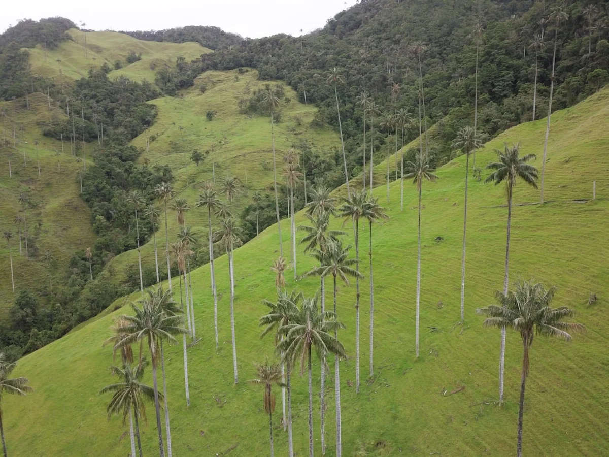
The Lost City Trek is widely regarded as one of the most rewarding yet physically demanding hikes in South America. While the total distance of 47 kilometres might seem modest over four days, the statistics do not account for the relentless "up and down" nature of the terrain or the debilitating effects of tropical humidity. The trail follows the Buritaca River valley, ascending from the dusty trailhead at El Mamey (also known as Machete Pelao) into the deep, humid heart of the Sierra Nevada de Santa Marta. This mountain range is a unique geographical anomaly—an isolated massif separate from the Andes, rising from the Caribbean coast to snow-capped peaks over 5,700 metres high in just 42 kilometres.
The experience is defined by its sensory intensity. Walkers must navigate narrow, red-clay paths that transform into slippery slides during the frequent afternoon downpours. There are multiple river crossings where the water can reach waist-height, requiring careful footing on moss-covered stones. The vegetation is a lush tapestry of giant ferns, towering palms, and ancient hardwoods draped in lianas. Wildlife is abundant but often heard rather than seen; the roar of howler monkeys, the flash of a blue morpho butterfly, and the constant chorus of cicadas provide the soundtrack to the trek. The heat is a constant factor, with temperatures often exceeding 30 degrees Celsius and humidity levels frequently reaching 90 percent, making every ascent feel twice as steep as it appears on a map.
The climax of the journey is the arrival at Teyuna itself. After three days of trekking, walkers face the final challenge: 1,200 narrow, moss-slicked stone steps that climb steeply from the riverbed to the lower terraces. Emerging from the canopy onto the cleared archaeological site is a moment of pure wonder. The city consists of approximately 169 terraces carved into the mountainside, connected by a complex network of tiled roads and small circular plazas. Unlike the manicured ruins of Peru, Ciudad Perdida feels raw and integrated into the forest. It is not a museum; it is a site of ongoing spiritual significance where indigenous leaders (Mamos) still perform ceremonies to maintain the balance of the world. The view from the upper terraces, looking back across the valley as the morning mist clings to the ridges, is one of the most spectacular sights in the world.
History and Cultural Context
The history of Ciudad Perdida is a narrative of resilience, loss, and rediscovery. The city was founded around 800 AD by the Tayrona civilisation, a sophisticated society known for their advanced engineering, gold-working, and complex social hierarchy. At its peak, Teyuna is estimated to have housed between 2,000 and 8,000 people. The Tayrona built their cities to harmonise with the mountain, using stone masonry that allowed for drainage in a region of extreme rainfall—a feat of engineering that has allowed the terraces to survive for over a millennium without collapsing.
When the Spanish arrived in the 16th century, the Tayrona resisted fiercely. However, the combination of warfare and European diseases eventually forced the abandonment of the city. While the Spanish never officially "found" Teyuna, the survivors of the Tayrona civilisation retreated higher into the Sierra Nevada, evolving into the four indigenous groups that exist today: the Kogi, Wiwa, Arhuaco, and Kankuamo. For these groups, the city was never "lost"; they continued to visit the site for spiritual purposes, keeping its location a secret from "Little Brother" (the non-indigenous world) to protect its sanctity.
The "official" rediscovery occurred in 1972 when a group of local treasure hunters, known as guaqueros, followed a series of stone steps up from the Buritaca River. They found gold ornaments and ceramic urns in the forest-covered mounds. Word of the "Green Hell" (as the looters called it) spread, leading to a period of violent conflict between rival looting gangs. In 1975, the Colombian government intervened, and the Colombian Institute of Anthropology and History (ICANH) began the formal process of excavation and restoration. The site was opened to tourism in the early 1980s, though it remained largely inaccessible for decades due to the presence of paramilitary groups and coca cultivation in the region. Since the mid-2000s, the area has been stabilised, and the trek is now a safe and highly regulated tourism destination.
Today, the cultural context of the trek is as important as the archaeology. The Sierra Nevada is considered by the indigenous inhabitants to be the "Heart of the World." They believe they are the "Elder Brothers" whose task is to protect the ecological and spiritual balance of the planet. Throughout the trek, walkers pass through indigenous villages and encounter Kogi or Wiwa people in their traditional white cotton clothing. Understanding their worldview—which emphasises the interconnectedness of all living things—is essential for anyone embarking on this journey. The trek is not just a walk through the woods; it is an entry into a territory where ancient laws and spiritual boundaries still dictate the rhythm of life.
Want more background? Read extended notes on history and cultural context → Learn more
Seasonal Highlights and Weather Reality
The Sierra Nevada de Santa Marta experiences a tropical climate with two distinct seasons, though the high altitude and dense forest create microclimates that can defy general forecasts. Understanding these seasons is crucial for physical preparation and managing expectations regarding views and trail conditions.
Dry Season (December to March): This is the most popular time to trek. The weather is generally more stable, with lower humidity and a significantly reduced chance of heavy rain. The trails are drier and less muddy, making the steep ascents and descents more manageable. River levels are lower, making crossings easier. However, this is also the busiest period, and the camps can be crowded. The heat can be intense during the day, as there is less cloud cover to provide shade.
Wet Season (April to November): During these months, the jungle is at its most vibrant and lush. The heat is slightly tempered by cloud cover, but the humidity is extreme. Afternoon downpours are almost guaranteed, often starting around 2:00 PM or 3:00 PM. These storms can be spectacular but turn the trail into a challenging quagmire of thick, red mud. River crossings become more adventurous, and the 1,200 steps to the city can be very slippery. The advantage of this season is the fewer number of trekkers and the dramatic atmosphere of the mist-filled valleys.
The September Closure: It is important to note that the Lost City Trek usually closes for the entire month of September. This is not due to weather, but at the request of the indigenous communities. They use this time to perform spiritual cleansing ceremonies (pagamentos) to heal the land from the impact of tourism and to allow the ecosystem to rest. Always check the specific dates before planning a trip in late August or early October.
Regardless of the season, walkers should be prepared for "jungle weather." This means being ready for sudden changes, high temperatures (25–32°C), and high humidity. Even in the dry season, a tropical storm can occur at any time. The nights in the higher camps (especially Camp 3) can be surprisingly cool, with temperatures dropping to around 15–18°C, requiring a light layer for sleeping.
Recommended Itinerary
4-Day Lost City Itinerary
Day 1: Santa Marta to El Mamey and Camp 1 (Adán or Alfredo)
- Distance: 7.6 km
- Elevation gain: 450 m
- Time: 3–4 hours
- Morning departure from Santa Marta via 4WD to the village of El Mamey
- Lunch in El Mamey before starting the trek
- The trail begins with a steady, sun-exposed climb on a dirt road/track
- Pass through farmland and secondary forest
- Arrive at Camp 1, which features a natural swimming hole in the river
- First night in hammocks or bunks with mosquito nets
- The heat on Day 1 is often the biggest challenge as you acclimatise to the humidity
Day 2: Camp 1 to Camp 3 (Paraíso Teyuna)
- Distance: 14.7 km
- Elevation gain: 600 m
- Time: 7–8 hours
- The longest and most demanding day of the trek
- Early start (usually 5:30 AM) to beat the midday heat
- Pass through the indigenous village of Mutanyi (Kogi community)
- Multiple steep ascents and descents through primary rainforest
- Lunch at Camp 2 (Mumake or Wiwa Camp)
- Cross the Buritaca River (may require wading)
- Arrive at Camp 3, the closest camp to the Lost City
- The terrain becomes more rugged and the forest more dense as you move deeper into the mountains
Day 3: Camp 3 to Ciudad Perdida and back to Camp 2
- Distance: 13 km (including exploration of the ruins)
- Elevation: 250 m gain to the city, then significant descent
- Time: 6–7 hours
- The highlight of the trek: 1,200 stone steps to reach the Lost City
- Spend 3–4 hours exploring the various terraces, ritual sites, and the "Map Stone"
- Guided explanation of the history and indigenous cosmology
- Return to Camp 3 for lunch
- Trek back down the valley, crossing the river again
- Arrive at Camp 2 (Mumake or Wiwa) for the final night
- The descent can be hard on the knees, especially if the trail is muddy
Day 4: Camp 2 to El Mamey and Santa Marta
- Distance: 12 km
- Elevation: Various ups and downs, mostly descending
- Time: 4–6 hours
- Final push back through the valley to the trailhead
- Stop at Camp 1 for a quick break or swim
- Final ascent over the ridge before the long descent into El Mamey
- Celebratory lunch in El Mamey
- 4WD transfer back to Santa Marta, arriving late afternoon
- The final kilometres are often the hottest as you leave the shade of the deep jungle
Important Notes:
- The itinerary is fixed by the tour operators; you cannot speed up or slow down independently
- All meals are provided by the tour cooks at the camps
- Water is provided but must be treated or filtered (most operators provide purified water)
- The "5-day" or "6-day" options follow the same route but involve shorter walking days and more time at the camps
- Be prepared for very early starts (often 5:00 AM) to maximise daylight and avoid afternoon rain
Planning and Bookings
Book Your Trip
Everything you need to plan your journey
Accommodation
Find places to stay near Santa Marta
Flights
Search flights to Santa Marta
Essential Preparation
The Lost City Trek requires significant logistical coordination, but unlike the Milford Track or Inca Trail, you do not need to book months in advance. However, you MUST book through an authorised tour operator. There are only a handful of licensed agencies (such as Expotur, Wiwa Tours, Magic Tour, and Guna Maku). These agencies are part of a local association that sets a fixed price for the trek, so shopping around for a "deal" is generally fruitless—the price is the same across all reputable providers.
Physical preparation is essential. While you don't need to be an elite athlete, you should have a good level of cardiovascular fitness and be comfortable walking 6–8 hours a day in extreme heat and humidity. Training on hills or stairs is highly recommended. Logistically, Santa Marta is the base for the trek. Most trekkers stay in the historic centre or the nearby beach suburb of Rodadero. You can leave your main luggage at your hotel or the tour operator's office, carrying only a small 25–35 litre pack for the trek itself.
Trail Accommodation
Accommodation on the Lost City Trek is basic and communal, designed to provide shelter in a challenging environment rather than luxury. The camps are managed by local families or indigenous communities and are shared by all the tour agencies.
Hut Facilities:
- Bunk beds or hammocks (assigned upon arrival)
- Mosquito nets (essential and provided for every bed/hammock)
- Basic blankets (usually provided, but a lightweight silk liner is recommended for hygiene)
- Communal dining areas with long tables
- Cold water showers (refreshing after a day of sweating)
- Flush toilets (basic but functional; toilet paper is usually provided but bring a backup)
- Limited electricity for charging devices (usually only for a few hours in the evening via generators)
- Small "tiendas" (shops) selling cold drinks, beer, and snacks
What Camps Don't Provide:
- Hot water (all showers are cold)
- Private rooms (all sleeping areas are dormitory-style)
- WiFi or mobile signal (you will be completely offline for the duration)
- Laundry services (clothes will not dry in the humidity; you must carry what you need)
- Towels or toiletries
Booking Requirements:
- Bookings can be made online or in person in Santa Marta
- A deposit is usually required to secure your spot
- The price is all-inclusive: transport, guide, meals, accommodation, and the entrance fee to the archaeological park
- Current cost (2024/2025): Approximately 2,150,000 COP (roughly US$500–550) for the 4-day trek
Required Gear
- Trekking boots or trail shoes - Must have excellent grip for mud and wet rock. Breathable mesh is better than Gore-Tex, as Gore-Tex won't let water out once it gets in (and it will)
- Lightweight backpack - 25–35 litres is sufficient. Use a waterproof liner or dry bags inside
- Moisture-wicking clothing - 2–3 sets of lightweight, quick-dry shirts and shorts. Avoid cotton at all costs
- Long trousers and long-sleeved shirt - For the evenings to protect against mosquitoes and "pito" bugs
- Socks - 3–4 pairs of high-quality trekking socks (merino wool blends work well)
- Sandals or flip-flops - For wearing around the camp and in the showers
- Rain poncho - A lightweight, breathable poncho is better than a heavy jacket in the heat
- Head torch - Essential for navigating the camps at night and early morning starts
- Personal first aid kit - Include blister pads (Compeed), antiseptic cream, and rehydration salts
What to Bring
- Insect repellent - High DEET concentration (40%+) or Picaridin. The mosquitoes and sandflies are persistent
- Sun protection - SPF50+ sunscreen, sunglasses, and a wide-brimmed hat
- Water purification - While camps provide water, bringing a LifeStraw or purification tablets provides extra security
- Toiletries - Biodegradable soap/shampoo, toothbrush, toothpaste, and a quick-dry travel towel
- Hand sanitiser - Use frequently, especially before meals
- Personal medications - Including anti-diarrheal tablets and any regular prescriptions
- Cash - Small denominations of Colombian Pesos for buying snacks, Gatorade, or beer at the camps
- Swimwear - For the river swimming holes
- Dry bags - To keep your electronics and dry clothes safe from humidity and rain
- Camera/Phone - With spare power bank (charging is limited)
Permits
The permit system for the Lost City Trek is unique because it is managed through the tour operators rather than a direct government booking portal. Your "permit" is essentially your booking with an authorised agency. These agencies work in coordination with the Colombian Institute of Anthropology and History (ICANH) and the indigenous authorities of the Sierra Nevada.
How the system works:
- When you book your trek, the agency registers your passport details with the park authorities
- A portion of your trek fee goes directly to ICANH for the maintenance of the archaeological site
- Another portion is paid as a "contribution" to the indigenous and peasant communities whose land you cross
- There are no "independent" permits available; you cannot walk this trail without a guide
Important Considerations:
- Availability: Unlike the Inca Trail, there is no strict daily cap that sells out months in advance. However, during the peak weeks of December and January, it is wise to book at least 2–3 weeks ahead to ensure your preferred departure date
- Indigenous Closures: As mentioned, the trail closes in September. Occasionally, additional closures may occur for spiritual reasons or environmental recovery. Your tour operator will be aware of these and will not book treks during these times
- Passport: You must bring your original passport (or a very clear colour photocopy) as there are checkpoints where authorities may verify your registration
Cost Breakdown: The fixed price (approx. 2,150,000 COP) covers everything. There are no hidden permit fees to pay at the trailhead. The only extra costs are for personal purchases at the camps (snacks/drinks) or if you choose to hire a mule to carry your pack (available at some sections for an additional fee paid directly to the muleteer).
Other Activities in the Area
The region surrounding Santa Marta is one of the most diverse in Colombia. Consider these activities before or after your trek:
- Tayrona National Natural Park: Located just an hour from Santa Marta, this park features some of the most beautiful beaches in the Caribbean, backed by thick jungle. You can hike to Cabo San Juan or stay overnight in a hammock.
- Minca: A small mountain village in the foothills of the Sierra Nevada. Known for its coffee and cacao farms, waterfalls (Marinka and Pozo Azul), and world-class birdwatching. It is significantly cooler than Santa Marta.
- Palomino: A laid-back beach town where the mountains meet the sea. Popular for "tubing" down the Palomino River, where you can drift through the jungle and see the snow-capped peaks in the distance.
- Santa Marta Historic Centre: Explore the oldest surviving city in Colombia. Visit the Cathedral, the Gold Museum (Museo del Oro Tairona), and the Quinta de San Pedro Alejandrino, where Simón Bolívar died.
- Taganga: A traditional fishing village turned scuba diving hub. It offers affordable diving courses and boat trips to secluded bays within Tayrona Park.
- Birdwatching: The Sierra Nevada is home to dozens of endemic bird species. Dedicated birding tours can be organised from Minca or Santa Marta.
Safety and Conditions
Health and Physical Safety:
- Hydration: This is the single biggest safety concern. The combination of heat and humidity leads to rapid fluid loss. You must drink at least 3–4 litres of water per day. Use rehydration salts (Electrolit or similar) every evening.
- Heat Exhaustion: Recognise the signs: dizziness, nausea, headache, and excessive sweating. If you feel unwell, inform your guide immediately. They are trained in basic first aid and can arrange for a mule or evacuation if necessary.
- Insects: Mosquitoes are common, but the "pito" bug (which can carry Leishmaniasis) is a concern in the deep jungle. Wear long sleeves and trousers in the evening and always use your mosquito net.
- Water Safety: Only drink water provided by the guides or water you have treated yourself. Do not drink directly from the river.
Terrain Hazards: The trail is often narrow and perched on steep slopes. Mud makes the clay surfaces incredibly slick. Use trekking poles (highly recommended) to maintain balance. During river crossings, follow your guide's instructions exactly; the current can be stronger than it looks. The 1,200 steps to the city are uneven and often covered in moss—take your time and use the handrails where available.
Security: The region is now stable and safe for tourism. The presence of the Colombian military and the regulation of the tour agencies have eliminated the security issues of the past. However, always stay with your group and follow your guide's advice. Do not wander off the marked trails.
Vaccinations: Yellow Fever vaccination is officially required for entering national parks in Colombia, including the Sierra Nevada. Carry your "Yellow Card" with you. Consult a travel clinic regarding Hepatitis A, Typhoid, and Malaria prophylaxis (though Malaria risk is generally low on the standard trek route).
Travel insurance is mandatory for most tour operators. Ensure your policy covers "hiking up to 1,500m" and emergency medical evacuation from remote areas.
Side Trips and Points of Interest
The Indigenous Village of Mutanyi: On Day 2, the trail passes through or near Mutanyi, a significant Kogi village. While you generally do not enter the private homes, seeing the traditional bohios (circular thatched huts) and the indigenous people going about their daily lives is a highlight. It is a reminder that the Sierra Nevada is a living cultural landscape, not just an archaeological site. Your guide will explain the significance of the white clothing (representing the purity of the snow) and the poporo (a ritual object used by men).
The Buritaca River Swimming Holes: Every camp is located near the Buritaca River. The natural pools and small waterfalls near Camp 1 and Camp 2 are the perfect remedy for "jungle fever." The water is cool, clear, and incredibly refreshing. Swimming in the river as the sun sets behind the jungle canopy is one of the most memorable experiences of the trek.
The "Map Stone": Located within the Lost City itself, this large boulder is carved with intricate lines that archaeologists believe may be a map of the Sierra Nevada and its various Tayrona settlements. It is a fascinating example of Tayrona cartography and cosmology.
The Upper Terraces (The Classic View): The most famous view of Ciudad Perdida is from the highest terraces. From here, you can see the symmetry of the circular plazas and the way the city follows the natural curve of the ridge. This is the best spot for photography, especially in the early morning when the mist is rising from the valley below.
Flora and Fauna: Keep an eye out for the "Walking Palm" (Socratea exorrhiza), which can slowly move its position to find better light. You may also see giant Ceiba trees, which were sacred to the Tayrona. Birdlife includes toucans, parrots, and the endemic Santa Marta Parakeet. If you are very lucky (and quiet), you might spot the tracks of a jaguar or ocelot in the mud, though the cats themselves are extremely elusive.
Leave No Trace
The Sierra Nevada de Santa Marta is an extremely fragile ecosystem and a sacred site for the indigenous people. As "Little Brothers," it is our responsibility to minimise our impact on this ancestral land. The indigenous communities believe that every action has a spiritual consequence, and they ask that visitors enter their territory with a clean heart and a respectful attitude.
Your responsibility as a walker:
- Waste Management: Pack out everything you pack in. Do not leave even "biodegradable" waste like banana peels or orange skins on the trail, as they can disrupt the local wildlife's diet. Use the bins provided at the camps.
- Cultural Respect: Never take photos of indigenous people (especially children) without asking for permission first. Some communities find photography intrusive or believe it captures a part of their soul. Your guide will advise you on when it is appropriate.
- Stay on the Path: The archaeological terraces are fragile. Only walk on the designated paths and do not climb on the ancient stone walls. The moss and lichens on the stones are part of the site's preservation.
- Water Protection: Do not use soap or shampoo directly in the river. Even "biodegradable" products can harm aquatic life in high concentrations. Use the showers provided at the camps.
- Noise Pollution: The jungle is a place of natural sound. Avoid playing music or shouting. Respect the silence of the archaeological site.
- No Souvenirs: It is strictly illegal to remove any archaeological fragments, stones, or plants from the site or the trail.
By following these principles, you help ensure that the Lost City remains a sacred and pristine place for the indigenous people and for future generations of trekkers. Walk with humility and leave only footprints.