The Lost City Trek - Colombia's Ancient Jungle Odyssey
Deep within the dense, emerald folds of the Sierra Nevada de Santa Marta—the world's highest coastal mountain range—lies Teyuna, better known as the Ciudad Perdida or "Lost City". Built by the Tayrona civilisation approximately 650 years before Machu Picchu, this archaeological marvel remained hidden from the outside world for centuries, reclaimed by the aggressive growth of the Colombian jungle. The Lost City Trek is not merely a hike; it is a profound journey through time, culture, and one of the most biodiverse ecosystems on the planet. Spanning 46 kilometres of challenging terrain, the route demands physical resilience and mental fortitude, rewarding walkers with a connection to the "Elder Brothers"—the indigenous Kogi, Wiwa, Arhuaco, and Kankuamo peoples who still guard these sacred lands. This is a pilgrimage into the heart of the "Heart of the World," where the humid air is thick with the scent of damp earth and the echoes of an ancient empire.
- Distance: 46.0 km return
- Duration: 4–6 days (4 days is the standard pace)
- Season: December to March (dry season); September (often closed for indigenous rituals)
- Accommodation: Jungle camps (hammocks or bunks with mosquito nets)
- Highest point: Teyuna Archaeological Site (1,200 m)
- Difficulty: Challenging (due to heat, humidity, and steep gradients)
- Access: Mandatory guided tour from Santa Marta or Taganga
- Direction: Out-and-back (same route for ascent and descent)
Overview
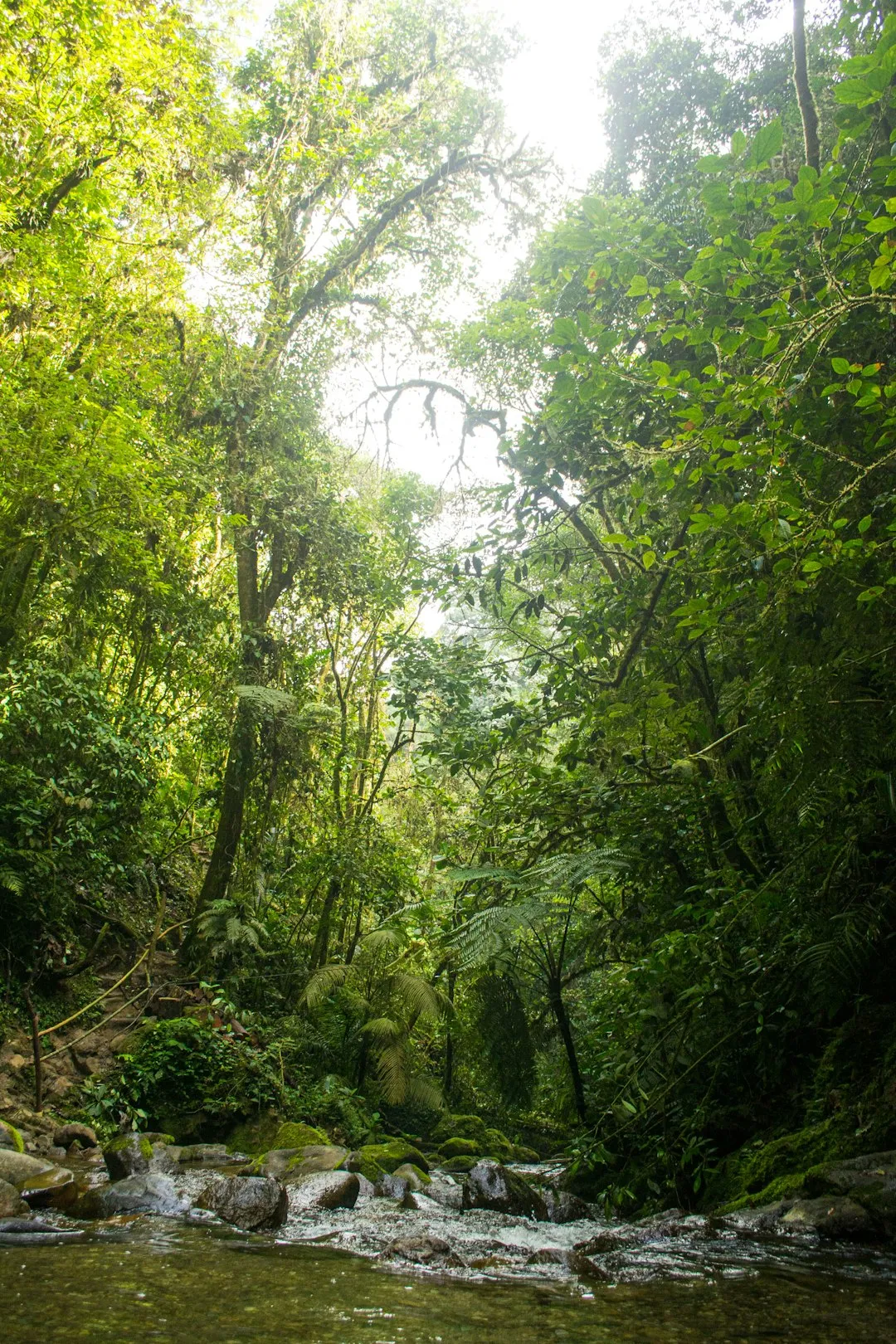
The Lost City Trek is widely regarded as one of South America’s most rewarding and physically demanding trekking experiences. Unlike many high-altitude Andean treks, the challenge here is not oxygen deprivation, but the relentless combination of tropical heat, extreme humidity, and the rugged verticality of the Sierra Nevada de Santa Marta. The trail is a masterclass in jungle navigation, weaving through primary rainforest, crossing the rushing turquoise waters of the Buritaca River multiple times, and ascending thousands of hand-hewn stone steps that have survived half a millennium of tropical erosion.
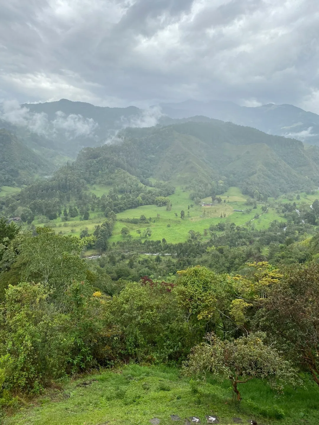
The journey begins in the small village of El Mamey (also known as Machete Pelao), where the transition from the Caribbean coast to the mountain foothills is immediate. From the outset, walkers are immersed in a landscape of staggering biological richness. The Sierra Nevada is an isolated massif, separate from the main Andes chain, which has allowed for the evolution of hundreds of endemic species. As you climb, the vegetation shifts from lowland tropical forest to lush cloud forest, where giant ferns and wax palms compete for sunlight beneath a canopy teeming with toucans, hummingbirds, and the elusive blue morpho butterfly.
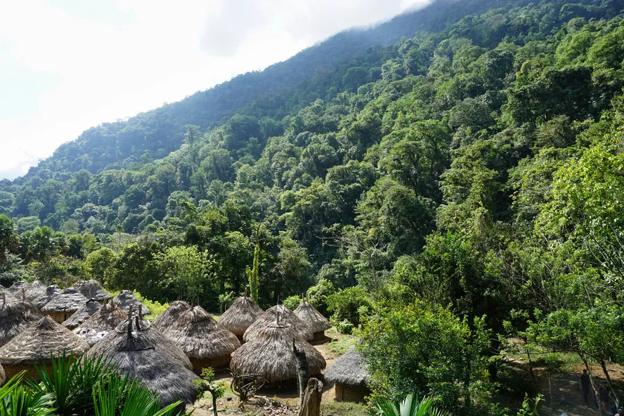
What sets the Lost City Trek apart from other archaeological hikes is the living culture that surrounds it. The trail passes through the territories of the four indigenous groups who are the direct descendants of the Tayrona. You will encounter Kogi families in their traditional white tunics, their presence a silent reminder that you are a guest in a sacred space. The trek culminates in the ascent of 1,200 ancient stone steps to reach the central terraces of Teyuna. Standing on these circular platforms, overlooking the mist-shrouded peaks of the Sierra, provides a sense of isolation and historical weight that few other sites can match. It is a place of profound spiritual significance, where the modern world feels impossibly distant.
History and Cultural Context
The history of Teyuna is a narrative of sophisticated engineering, tragic abandonment, and a modern-day resurrection. Built around 800 AD by the Tayrona people, the city served as a major political and religious centre for a network of villages scattered across the Sierra Nevada. The Tayrona were master architects of the mountains, developing a complex system of stone terraces, tiled roads, and drainage channels designed to prevent the city from being washed away by the region's torrential rains. At its peak, it is estimated that between 2,000 and 8,000 people lived in Teyuna, supported by advanced agricultural techniques on the surrounding slopes.
Following the Spanish conquest in the 16th century, the city was abandoned. While the indigenous peoples maintained knowledge of its existence, the site was swallowed by the jungle and remained unknown to the Western world for nearly 400 years. It was "rediscovered" in 1972 by a group of local treasure hunters, or huaqueros, who stumbled upon the stone steps while searching for gold. This discovery led to a period of looting and conflict between rival gangs of treasure hunters, until the Colombian government intervened in 1975, dispatching archaeologists to protect and restore the site.
Today, the site is managed by the Colombian Institute of Anthropology and History (ICANH) in close collaboration with the indigenous authorities. For the Kogi, Wiwa, Arhuaco, and Kankuamo, Teyuna is not a "ruin" but a living temple. They refer to themselves as the "Elder Brothers" and view the rest of humanity as "Younger Brothers" who have lost their way and are damaging the Earth. The trek offers a rare opportunity to learn about their philosophy of Aluna—the cosmic consciousness that connects all living things. The preservation of the site is as much about protecting this spiritual heritage as it is about maintaining the physical stones.
Want more background? Read extended notes on history and cultural context → Learn more
Seasonal Highlights and Weather Reality
The climate of the Sierra Nevada de Santa Marta is characterised by two distinct seasons: the dry season and the wet season. Because of its proximity to the equator and the Caribbean Sea, the weather is consistently hot and humid, with temperatures often exceeding 30°C during the day and dropping to a relatively cool 15–18°C at night in the higher camps.
Dry Season (December to March): This is the most popular time to undertake the trek. The trails are firmer, river crossings are shallower and safer, and there is a higher probability of clear views at the archaeological site. However, the heat can be more intense during these months, and the trail is at its busiest. Dust can also be a factor on the lower sections of the path.
Wet Season (April to November): During the rainy season, the jungle truly comes alive. The flora is at its most vibrant, and the waterfalls are spectacular. However, the trek becomes significantly more difficult. The trail turns into a thick, slippery mud that can slow progress and increase the risk of falls. Rain typically falls in heavy afternoon deluges, which can cause the Buritaca River to rise rapidly, occasionally delaying crossings. October is generally the wettest month.
The September Closure: It is crucial to note that the Lost City Trek usually closes for the entire month of September. This is at the request of the indigenous communities, who use this time to perform spiritual cleansing rituals and allow the environment to recover from the impact of tourism. Always check the specific dates for the current year before planning your trip.
Recommended Itinerary
4-Day Lost City Itinerary
Day 1: El Mamey to Camp 1 (Adán or Alfredo)
- Distance: 7.6 km
- Elevation gain: 450 m
- Time: 3–4 hours
- Depart Santa Marta by 4WD for a 3-hour drive to El Mamey
- Lunch in the village before starting the ascent
- The trail begins with a steep, exposed climb on a dirt road
- Pass through farmland and secondary forest
- Arrive at Camp 1, featuring a natural swimming hole in the river
- First night in the jungle; introduction to the humidity and communal camp life
Day 2: Camp 1 to Camp 3 (Paraíso Teyuna)
- Distance: 14.7 km
- Elevation gain: 600 m
- Time: 7–8 hours
- The longest and most demanding day of the trek
- Early morning start to avoid the midday heat
- Pass through the indigenous village of Mutanyi (Kogi community)
- Multiple crossings of the Buritaca River (water can be waist-deep)
- Steep ascent through primary rainforest with significant humidity
- Arrive at Camp 3, the final camp before the Lost City
- Rest and prepare for the final ascent the following morning
Day 3: Camp 3 to The Lost City and return to Camp 2 (Mumake)
- Distance: 13.5 km
- Elevation: 350 m gain to the site, then descent
- Time: 7–8 hours
- Early morning crossing of the river to reach the base of the city
- Climb the 1,200 ancient stone steps to the main terraces
- 3–4 hours exploring the archaeological site, including the "Map of the Lost City" and the upper terraces
- Meet with a local indigenous leader (if available) for a cultural talk
- Descend back to Camp 3 for lunch
- Continue the trek back down the valley to Camp 2 (Mumake)
- Evening spent sharing stories of the city's grandeur
Day 4: Camp 2 to El Mamey
- Distance: 10.2 km
- Elevation: Mostly descent with one final significant climb
- Time: 4–6 hours
- Final push back towards civilisation
- The trail retraces the path from Day 1, but the perspective is different
- Stop for a final swim in the river to cool off
- Arrive back in El Mamey for a celebratory lunch
- Return 4WD transfer to Santa Marta or Taganga
- End of the journey by late afternoon
Important Notes:
- Itineraries are fixed by the tour operators; you cannot walk independently
- River crossings are weather-dependent; guides may alter the schedule for safety
- Mules are used to carry food and supplies, but you must carry your own personal gear
- Hydration is critical; water is provided at camps but must be treated or filtered
- The 5-day and 6-day options follow the same route but allow for more relaxation and shorter walking days
Planning and Bookings
Book Your Trip
Everything you need to plan your journey
Accommodation
Find places to stay near Santa Marta
Flights
Search flights to Santa Marta
Essential Preparation
The Lost City Trek is a mandatory guided experience. You cannot legally or safely attempt this walk without an authorised tour operator. These agencies work in partnership with the local communities and the government to manage the trail. Booking in advance is recommended, especially during the peak dry season (December–January), although it is often possible to join a group with a few days' notice in Santa Marta.
Physical preparation is essential. While the total distance of 46 km might seem modest over four days, the combination of steep gradients and 90% humidity makes it feel much longer. Cardiovascular fitness and leg strength are vital. It is highly recommended to spend at least two days in Santa Marta or the surrounding coastal area prior to the trek to acclimatise to the tropical heat. Santa Marta serves as the primary hub, offering a range of accommodation from hostels to boutique hotels, as well as storage facilities for the luggage you won't be taking on the trail.
Trail Accommodation
Accommodation on the Lost City Trek consists of basic, communal jungle camps. These are rustic but well-organised, designed to provide shelter in a challenging environment.
Hut Facilities:
- Bunk beds or hammocks equipped with mosquito nets (essential for protection against insects)
- Basic blankets and pillows are usually provided, but many hikers prefer a lightweight silk liner
- Communal dining areas where group meals are served
- Flush toilets and cold-water showers (refreshing after a day of sweating)
- Small kiosks selling snacks, bottled water, and occasionally cold beer or soda
- Limited electricity for charging devices (usually via generator for a few hours in the evening)
- Hand-washing stations for laundry
What Huts Don't Provide:
- Private rooms or secluded sleeping areas
- Hot water (all showers are cold)
- WiFi or mobile phone reception
- Towels or toiletries
- Quiet—the jungle is loud, and camps are social environments
Booking Requirements:
- Bookings are made through authorised agencies (e.g., Expotur, Wiwa Tours, Magic Tour)
- The cost is standardised across all agencies to ensure fair competition and community support
- Current cost (2024/2025): Approximately 1,800,000 to 2,150,000 COP (Colombian Pesos) for the 4-day trek
- The price includes all transport, food, accommodation, guide services, and the contribution to the indigenous and peasant communities
Required Gear
- Trekking boots or sturdy trail shoes - must have excellent grip for mud and wet stone
- Lightweight backpack - 25–35L is sufficient as you only carry personal items
- Dry bags or heavy-duty plastic liners - essential to keep clothes dry during rain and river crossings
- Waterproof jacket or lightweight poncho - for the inevitable afternoon downpours
- Trekking poles - highly recommended for stability on slippery descents and river crossings
- Head torch - essential for navigating the camps at night
- Personal first aid kit - including blister pads, antiseptic cream, and rehydration salts
- Quick-dry towel - microfibre is best for the humid conditions
What to Bring
- Clothing - 3 sets of lightweight, breathable trekking clothes (merino or synthetic, avoid cotton)
- Evening wear - one clean, dry set of clothes kept strictly for sleeping
- Swimwear - for river crossings and swimming holes
- Insect repellent - high DEET concentration (30%+) or Picaridin is necessary for mosquitoes and sandflies
- Sun protection - SPF50+ sunscreen, wide-brimmed hat, and sunglasses
- Water purification - while camps provide boiled/filtered water, tablets or a LifeStraw provide extra security
- Toiletries - biodegradable soap, toothbrush, toothpaste, and plenty of toilet paper
- Snacks - energy bars, nuts, or dried fruit to supplement the provided meals
- Cash - small denominations of COP for buying snacks or drinks at the camps
- Camera/Phone - with extra power banks as charging is limited
Permits
Unlike many national parks where you must apply for a permit months in advance, the "permit" for the Lost City Trek is effectively your booking with an authorised tour operator. The Colombian government and the indigenous councils limit the number of people on the trail by controlling the number of licensed agencies and the size of the groups they can take.
Booking and Registration:
- When you book your trek, the agency will require your passport details to register you with the local authorities and the ICANH
- You must carry your original passport (or a very clear colour photocopy) during the trek, as there are occasional checkpoints managed by the army or park rangers
- The cost of the "permit" and the entrance fee to the Teyuna Archaeological Park is included in the total price of your tour
- There is no way to purchase a permit independently of a guided tour
Community Contributions: A significant portion of your trek fee goes directly to the indigenous and peasant (campesino) communities that live along the route. This "social tax" supports local schools, healthcare, and infrastructure, ensuring that tourism provides a tangible benefit to the people whose land you are traversing. This system has been instrumental in moving the region away from the coca-growing economy of the past towards a sustainable tourism model.
Insurance: Most reputable agencies include a basic travel insurance policy in their price, covering accidents on the trail. However, this is often limited. It is strongly advised to have your own comprehensive international travel insurance that specifically covers trekking up to 1,500 metres and emergency medical evacuation.
Other Activities in the Area
The Caribbean coast of Colombia offers a wealth of experiences to complement your trek:
- Tayrona National Natural Park: Located just an hour from Santa Marta, this park features some of the most beautiful beaches in South America, framed by giant boulders and jungle. It is the perfect place to recover after the trek.
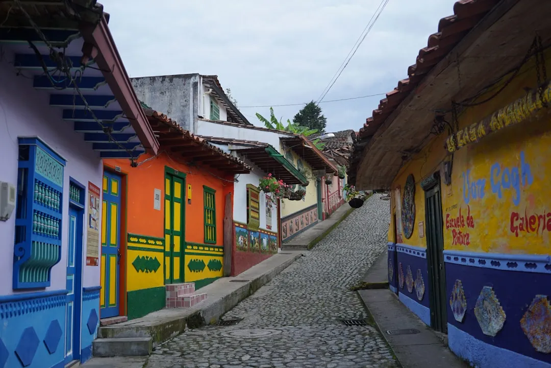
- Minca: A mountain village in the foothills of the Sierra Nevada, famous for its organic coffee farms, chocolate production, and birdwatching. It offers a cooler climate and a relaxed atmosphere.
- Palomino: A laid-back beach town known for "tubing" down the Palomino River, where you can float from the jungle all the way to the sea.
- Santa Marta Historic Centre: Explore the oldest surviving city in Colombia, visit the cathedral, and enjoy the vibrant nightlife and dining scene around Parque de los Novios.
- Quinta de San Pedro Alejandrino: The hacienda where Simón Bolívar, the liberator of South America, spent his final days. It is a beautiful site with botanical gardens and historical monuments.
- Taganga: A former fishing village turned backpacker hub, famous for its sunsets and affordable scuba diving certification courses.
Safety and Conditions
Health and Physical Risks:
- Heat Exhaustion and Dehydration: This is the most common issue on the trail. The humidity prevents sweat from evaporating, making it easy to overheat. Drink at least 3–4 litres of water a day and use rehydration salts.
- Tropical Diseases: While malaria is rare in this specific area, Dengue fever and Zika are present. Use high-quality insect repellent and wear long sleeves/trousers in the evenings. Yellow fever vaccination is recommended for travel to this region of Colombia.
- Foot Care: The constant dampness can lead to trench foot or severe blisters. Change into dry socks as soon as you reach camp and treat any "hot spots" immediately.
- Water Safety: Never drink untreated water from the river. Use the water provided at camps or your own purification system.
Environmental Hazards: The Buritaca River can be unpredictable. During heavy rain, it can transform from a gentle stream into a raging torrent within minutes. Always follow your guide's instructions regarding river crossings. The stone steps at the Lost City are often covered in moss and can be incredibly slippery; take your time and use the handrails where available. Snakes and spiders exist in the jungle, but they are generally shy; avoid sticking your hands into thick vegetation or hollow logs.
Security: The Sierra Nevada de Santa Marta has a complex history involving various armed groups. However, in recent years, the trekking route has become very safe. The presence of the Colombian army and the vested interest of the local communities in tourism have created a secure corridor for hikers. Stick to the marked trail and always stay with your group.
Emergency Evacuation: In the event of a serious injury, evacuation is typically done by mule to the nearest road access, which can take several hours. In extreme life-threatening cases, helicopter evacuation may be possible, but this is weather-dependent and very expensive, highlighting the need for comprehensive insurance.
Side Trips and Points of Interest
The 1,200 Steps: The final approach to Teyuna is an experience in itself. These narrow, moss-covered stone steps climb steeply from the riverbank. They are a testament to Tayrona engineering, designed to be easily defended and to withstand the tropical elements. Climbing them in the early morning mist is a highlight of the journey.
The Map of the Lost City: Near the entrance to the site lies a large, flat rock carved with intricate lines. Local guides and archaeologists believe this is a "map" of the city and the surrounding mountain ridges, used by the Tayrona to plan their urban expansion and agricultural terraces.
The Upper Terraces: The most iconic view of the Lost City is from the highest terraces. From here, you can see the symmetry of the circular foundations and the way the city was integrated into the ridge line. This is the site of the "Great Temple" and was likely the residence of the highest-ranking priests and leaders.
Indigenous Encounters: Throughout the trek, you will pass through or near indigenous settlements. While some are off-limits to tourists, others allow for brief visits. Observing the traditional way of life—weaving, the use of the poporo (a gourd used for chewing coca leaves), and the unique architecture of the round, thatched huts—is a profound cultural experience. Always ask for permission before taking photographs of indigenous people.
Natural Swimming Holes: The Buritaca River offers numerous deep, cool pools perfect for swimming. The pool at Camp 1 and the "Pozo de la Juventud" (Well of Youth) near the Lost City are particularly refreshing. The water is crystal clear and provides a much-needed respite from the jungle heat.
Leave No Trace
The Sierra Nevada de Santa Marta is a fragile ecosystem and a sacred ancestral land. As visitors, we have a moral and environmental obligation to minimise our impact. The "Elder Brothers" believe that every action in the physical world has a spiritual consequence, and they ask that we treat their home with the utmost respect.
Your responsibility as a walker:
- Waste Management: Pack out everything you pack in. Do not leave even small items like cigarette butts or fruit peels on the trail. Use the bins provided at the camps.
- Water Protection: Use biodegradable soaps and shampoos. When bathing in the river, do not use any soap at all, as it can harm the aquatic life and the communities downstream who rely on the river for drinking water.
- Respect Wildlife: Observe animals from a distance. Do not feed any wildlife, as this disrupts their natural diet and behaviour.
- Stay on the Path: The jungle floor is a complex web of roots and small plants. Straying from the trail causes erosion and destroys habitat.
- Cultural Sensitivity: Do not give sweets, money, or gifts to indigenous children. This creates a culture of begging and dependency. If you wish to contribute, do so through your tour agency or by supporting community projects.
- Silence and Respect: Teyuna is a place of worship. Keep your voice low while exploring the site and respect any areas that are marked as restricted for spiritual reasons.
By following these principles, you help ensure that the Lost City remains a pristine and sacred destination for future generations of both "Younger" and "Elder" brothers.