Lofoten Islands Coastal Trek - An Arctic Odyssey
The Lofoten Islands Coastal Trek is a breathtaking 100-kilometre journey through one of the most dramatic landscapes on Earth. Located well above the Arctic Circle in Northern Norway, this trek traverses the archipelago from the bustling hub of Svolvær in the east to the iconic, single-lettered village of Å in the west. The route is a masterclass in coastal drama, where jagged granite peaks—some over 3,000 million years old—rise vertically from the turquoise depths of the Norwegian Sea. Hikers will navigate a tapestry of white-sand beaches that look more Caribbean than Arctic, emerald-green mountain passes, and ancient fishing villages where the scent of drying stockfish lingers in the salt air. This is not merely a walk; it is an immersion into a landscape defined by the relentless power of the North Atlantic and the resilient culture of the people who have called these islands home for millennia.
- Distance: 100.0 km one-way
- Duration: 5–7 days
- Season: June to September (Midnight Sun in June/July; Autumn colours in September)
- Elevation Gain: 3,000 m total
- Difficulty: Moderate (requires good fitness and navigation skills)
- Highest point: Approximately 600 m (depending on specific pass crossings)
- Closest City: Svolvær
- Trailhead Access: Fly into Leknes or Svolvær; excellent local bus network (Bus 741)
Overview
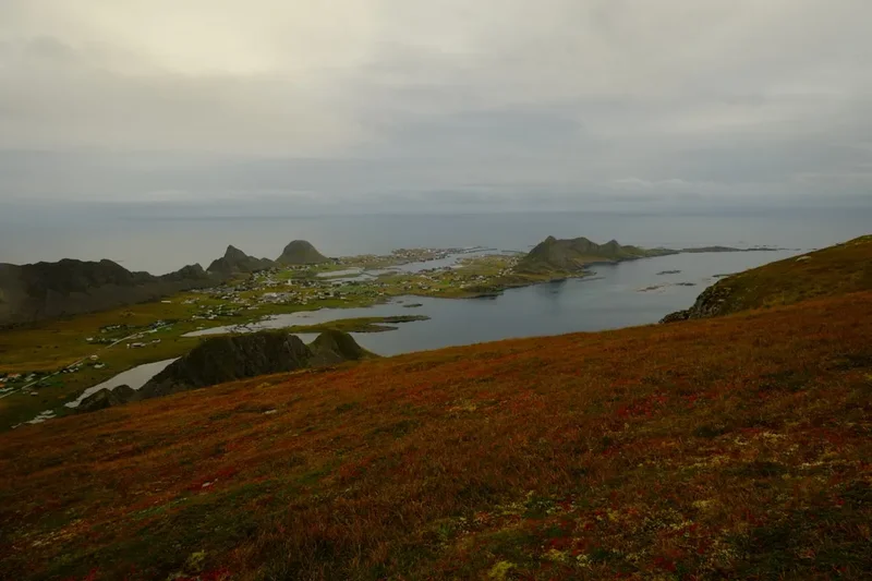
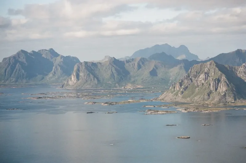
The Lofoten Islands Coastal Trek offers a unique hiking experience that defies traditional mountain trekking logic. Because the islands are an archipelago, the "trail" is a curated sequence of coastal paths, old postal routes, and mountain passes that link the various islands of Austvågøya, Gimsøya, Vestvågøya, Flakstadøya, and Moskenesøya. The terrain is famously varied; one hour you may be strolling along a flat, sandy beach like Ramberg or Kvalvika, and the next you could be scrambling up a steep, muddy gully to reach a high mountain saddle. The elevation gain of 3,000 metres is spread across the entire 100 kilometres, meaning that while there are no massive alpine climbs, the constant "up and down" nature of the coastal topography provides a sustained physical challenge.
What sets this trek apart is the light. During June and July, the region experiences the Midnight Sun, where the sun never dips below the horizon. This provides hikers with 24 hours of daylight, allowing for incredible flexibility in itinerary planning—you can hike at 2:00 AM to avoid the midday heat or to witness the landscape bathed in a perpetual golden hour. By August and September, the nights return, bringing with them the possibility of witnessing the Aurora Borealis (Northern Lights) dancing over the peaks. The weather, however, is the ultimate arbiter of the experience. The Lofoten Islands are situated in the path of the Gulf Stream, which keeps the climate surprisingly mild for its latitude, but it also brings rapid, unpredictable changes. A clear blue sky can transform into a horizontal rainstorm within twenty minutes, requiring hikers to be prepared for all four seasons in a single afternoon.
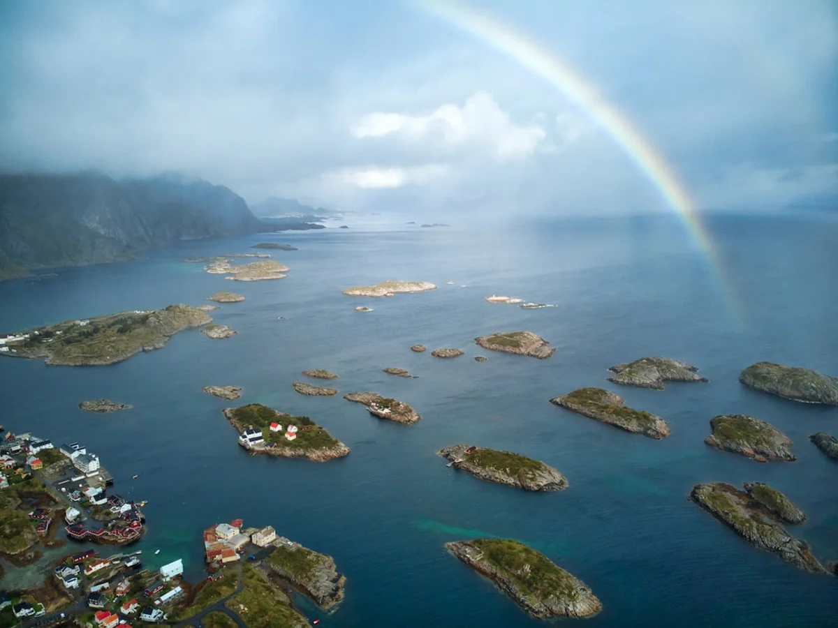
The trek is also a cultural journey. You will pass through villages like Henningsvær, often called the "Venice of the North," and Nusfjord, one of Norway's oldest and best-preserved fishing hamlets. The sight of "hjell" (wooden racks) laden with drying cod is a constant reminder of the region's thousand-year-old fishing heritage. The infrastructure for hikers is excellent, with a mix of wild camping opportunities (protected by Norway's "Allemannsretten" or Right to Roam) and traditional "rorbuer"—historic fishermen's cabins that have been converted into high-quality accommodation. Whether you are seeking the solitude of a remote Arctic beach or the warmth of a coastal village, the Lofoten Coastal Trek delivers a sense of scale and beauty that is truly world-class.
History and Cultural Context
The history of the Lofoten Islands is inextricably linked to the sea. Human habitation in the archipelago dates back over 11,000 years, with early settlers drawn by the immense biological productivity of the surrounding waters. The islands are the primary spawning grounds for the North Atlantic Cod (Skrei), which migrate from the Barents Sea every winter. This annual event, known as the "Lofotfisket," has been the backbone of the local economy for centuries. By the Viking Age, Lofoten was a seat of significant power; the chieftain's house at Borg (on the island of Vestvågøya) was the largest Viking building ever discovered, measuring 83 metres in length. This site, now the Lofotr Viking Museum, sits directly along the trekking route and provides a profound look into the lives of the Norse explorers who once navigated these fjords.
In the medieval period, the export of "stockfish" (unsalted, air-dried cod) to mainland Europe became a massive industry, controlled largely by the Hanseatic League in Bergen. This trade necessitated the construction of "rorbuer"—small, seasonal cabins built on stilts over the water to house the thousands of fishermen who flocked to the islands each winter. Many of the villages you walk through today, such as Reine and Nusfjord, still retain these iconic red and ochre structures, which have become symbols of the Norwegian coast. The paths used for the trek often follow the old "postveien" (postal roads) or the tracks used by locals to move livestock between summer and winter pastures.
The landscape itself is a geological marvel. The mountains of Lofoten are composed of some of the oldest rocks in the world, primarily mangerite and charnockite, which were formed deep in the Earth's crust during the Precambrian era. These rocks were later sculpted by successive ice ages, which carved the deep fjords and sharp "horns" that give the islands their distinctive silhouette. To the local Sámi people and the Norwegian settlers, these mountains were often seen as sentient beings or landmarks for navigation. Today, the trek represents a modern chapter in this history—a transition from an economy based solely on extraction to one that celebrates the preservation and appreciation of the wilderness.
Want more background? Read extended notes on history and cultural context → Learn more
Seasonal Highlights and Weather Reality
Timing is everything when planning a trek in the Arctic. The window for the Lofoten Coastal Trek is relatively short, typically spanning from early June to late September. Outside of these months, the mountains are covered in snow, and many of the higher passes become dangerous or impassable for those without specialised winter mountaineering skills and equipment.
Summer (June and July): This is the season of the Midnight Sun. From late May to mid-July, the sun does not set, providing endless light for hiking. This is the most popular time to visit, as the weather is generally at its most stable and the flora is in full bloom. However, "stable" in Lofoten is a relative term; temperatures usually hover between 10°C and 18°C, but can drop to 5°C in rain. This is also the peak season for tourism, meaning popular spots like Reine and Svolvær will be busy.
Late Summer (August): August is often considered the best month for trekking. The Midnight Sun has ended, but the days are still very long, and the ground has had time to dry out from the spring melt. The berries—blueberries, crowberries, and the prized "Arctic gold" cloudberries—are ripe for picking along the trail. The water temperatures, while still bracing, are at their warmest for those brave enough to swim at Kvalvika or Haukland Beach.
Autumn (September): September brings a dramatic transformation. The crowds disappear, and the landscape turns into a riot of orange, red, and gold. This is the best time for photography, as the sun sits lower in the sky, creating long shadows and soft light. Crucially, the nights become dark enough to see the Northern Lights. However, the weather becomes significantly more volatile, with increased rainfall and the first dustings of snow on the peaks. Many seasonal ferries and buses reduce their frequency in mid-September.
Winter and Spring (October to May): During the "Mørketid" (Polar Night) from December to January, the sun never rises. While the islands are stunning in the snow, the Coastal Trek as a continuous walking route is not feasible. Spring (April and May) is the season of the "Skrei" fishing, but the hiking trails are often a mix of deep snow and treacherous slush.
Recommended Itinerary
7-Day Lofoten Coastal Trek Itinerary
Day 1: Svolvær to Kabelvåg and Hopen
- Distance: 14 km
- Elevation gain: 250 m
- Time: 4–5 hours
- Start in Svolvær, the administrative centre of Lofoten
- Follow the coastal path south towards the historic village of Kabelvåg
- Visit the "Lofoten Cathedral" (Vågan Church), the largest wooden building in Northern Norway
- Continue along the shoreline to Hopen, with views of the Svolværgeita rock formation
- Camp near the coast or stay in a local guesthouse
Day 2: Hopen to Kleppstad (Gimsøya)
- Distance: 16 km
- Elevation gain: 400 m
- Time: 5–6 hours
- Cross the bridge to the island of Gimsøya
- The terrain becomes flatter and more marshy, typical of the central islands
- Pass through the village of Sydalen
- Spectacular views of the mountain "Hoven" rising in isolation from the flatlands
- Arrive in Kleppstad, a quiet area perfect for wild camping with views across the sound
Day 3: Kleppstad to Borg (Lofotr)
- Distance: 18 km
- Elevation gain: 500 m
- Time: 6–7 hours
- Enter the island of Vestvågøya, the agricultural heart of Lofoten
- The trail climbs over a scenic pass with views of the inner fjords
- Descend into the valley of Borg
- Visit the Lofotr Viking Museum to see the reconstructed Chieftain's House
- This section offers a mix of farm tracks and mountain paths
Day 4: Borg to Unstad and Eggum
- Distance: 15 km
- Elevation gain: 450 m
- Time: 5–6 hours
- Hike towards the outer coast and the famous surfing beach of Unstad
- The path between Unstad and Eggum is a classic coastal route, hugging the cliffs
- Pass the "Head" sculpture, part of the Artscape Nordland project
- Eggum is a prime spot for viewing the Midnight Sun over the open ocean
- Stay at the Eggum community campsite or wild camp in the designated areas
Day 5: Eggum to Leknes and Ballstad
- Distance: 17 km
- Elevation gain: 300 m
- Time: 6 hours
- Follow the old coastal road towards the town of Leknes
- Stock up on supplies in Leknes, the largest shopping hub on the islands
- Continue south to the fishing village of Ballstad, one of the largest in Lofoten
- Ballstad is famous for its vibrant rorbuer and active fishing fleet
- Excellent opportunities for a "rorbu" stay to recharge
Day 6: Ballstad to Nusfjord and Ramberg
- Distance: 12 km (plus bus/ferry link)
- Elevation gain: 600 m
- Time: 5–6 hours
- This day involves a steep climb over the mountain pass to the UNESCO-listed village of Nusfjord
- Nusfjord is a living museum; take time to explore the old general store and sawmill
- From Nusfjord, take a local bus or pre-arranged boat to Flakstad/Ramberg
- Walk along the massive white sands of Ramberg Beach
- Camp at the Ramberg beachside campsite
Day 7: Ramberg to Reine and Å
- Distance: 8 km (hiking) + transport links
- Elevation gain: 500 m (optional Reinebringen climb)
- Time: 4–5 hours
- Travel to Reine, arguably the most beautiful village in Norway
- OPTIONAL: Climb the stone stairs of Reinebringen for the iconic view of the Reinefjord
- Continue the final stretch to the village of Å, where the road ends
- Explore the Norwegian Fishing Village Museum in Å
- Celebrate the completion of the 100 km trek at the local bakery (famous for cinnamon buns)
Important Notes:
- The route uses a combination of hiking trails and local transport (buses/ferries) to bridge gaps between islands
- Wild camping is permitted but must be at least 150 metres from inhabited houses
- Water is plentiful and generally safe to drink from mountain streams
- The "Lofoten Express" (Bus 300) runs the length of the islands and is very reliable
- Always check the weather forecast (Yr.no) before attempting mountain passes
Planning and Bookings
Book Your Trip
Everything you need to plan your journey
Accommodation
Find places to stay near Svolvær
Flights
Search flights to Svolvær
Essential Preparation
Planning a 100-kilometre trek in the Arctic requires careful logistical coordination. Unlike many European treks, the Lofoten Coastal Trek does not have a single "official" booking office. Instead, it is a self-guided journey that requires you to manage your own transport and accommodation. The first step is deciding your direction; most hikers travel from East to West (Svolvær to Å) to keep the most dramatic scenery of the Moskenesøya mountains for the finale.
Fitness is a key requirement. While the "Moderate" rating suggests accessibility, the terrain is often rugged. You should be comfortable walking 15–20 kilometres per day with a 12–15 kg pack. Training should include plenty of elevation gain and walking on uneven, boggy surfaces. Logistics-wise, download the "Entur" app for all Norwegian public transport schedules and the "113" emergency app, which provides your exact coordinates to rescue services if needed. Svolvær and Leknes are the best places to base yourself before starting, as they have full-service outdoor shops and supermarkets.
Trail Accommodation
Accommodation on the Lofoten Coastal Trek is a highlight of the experience, offering a range of options from rugged wild camping to luxury historic cabins.
Wild Camping: Under the Norwegian law of "Allemannsretten," you can camp almost anywhere in the wilderness for up to two nights, provided you are at least 150 metres from the nearest house or cabin. In high-traffic areas like Reine, Kvalvika, and Moskenes, specific restrictions may apply to protect the environment. Always look for established "impact zones" to pitch your tent.
Rorbuer (Fishermen's Cabins): These are the iconic red cabins found in almost every village (Svolvær, Henningsvær, Ballstad, Nusfjord, Reine, Å).
- Facilities: Usually include a kitchen, private bathroom, and multiple bedrooms.
- Booking: Essential during summer months; these sell out months in advance.
- Cost: High (expect 1,500–3,000 NOK per night).
- Availability: Year-round, but some smaller operators close in winter.
Campsites: Organised campsites (e.g., in Ramberg, Moskenes, and Eggum) provide essential facilities.
- Provided: Showers (usually coin-operated), kitchens, laundry, and Wi-Fi.
- Not Provided: Tents or sleeping gear.
- Cost: 250–400 NOK per night for a tent and two people.
DNT Huts: The Norwegian Trekking Association (DNT) has a few cabins in the Lofoten mountains (like Munkebu), but they are fewer than in mainland Norway. These require a DNT key and pre-booking.
Required Gear
- Hiking Boots: Waterproof (Gore-Tex) with high ankle support. The trails are notoriously muddy and rocky.
- Rain Shell: A high-quality, 3-layer waterproof jacket and overtrousers. Arctic rain is often wind-driven and persistent.
- Backpack: 50–65L with a waterproof cover and a well-fitted harness.
- Insulation: A lightweight down or synthetic "puffy" jacket for evenings, even in summer.
- Base Layers: Merino wool is essential. It stays warm when wet and resists odours over multiple days.
- Navigation: A physical map (Turkart Lofoten 1:50,000) and a GPS/Smartphone with offline maps (UT.no or Gaia GPS).
- Tent: A sturdy, 3-season tent capable of withstanding high winds.
- Sleeping System: A sleeping bag with a comfort rating of 0°C to 5°C and an insulated sleeping mat.
What to Bring
- Food: Lightweight, dehydrated meals for the trail. While you pass through villages, eating out in Norway is extremely expensive.
- Stove and Fuel: A canister stove (Jetboil or MSR). Gas canisters (screw-top) can be bought in Svolvær or Leknes.
- Water Treatment: While mountain water is generally pure, a lightweight filter (like a Sawyer Squeeze) is recommended if taking water near sheep grazing areas.
- Sun Protection: SPF 50 sunscreen and sunglasses. The Arctic sun is surprisingly strong, especially with reflection off the sea.
- Eye Mask: Essential for sleeping during the Midnight Sun.
- Power Bank: To keep your phone/GPS charged, as charging points are only available at campsites or rorbuer.
- First Aid: Blister kits (Compeed), antiseptic wipes, and any personal medications.
- Insect Repellent: Midges and mosquitoes can be an issue in boggy areas during July and August.
Permits
One of the greatest joys of hiking in Norway is the lack of a formal permit system for the trail itself. There is no "Lofoten Trekking Permit" required to walk the 100-kilometre route. This freedom is enshrined in the 1957 Outdoor Recreation Act, which guarantees the public's right to access and enjoy the wilderness.
Key Regulations to Observe:
- Right to Roam (Allemannsretten): You can walk anywhere in the "outfield" (uncultivated land). You must not walk through farmyards or cultivated fields (infields) during the growing season.
- Camping Restrictions: While wild camping is generally free, certain "hotspots" in Lofoten have implemented local bans or designated camping zones to prevent erosion and waste issues. This includes parts of Reinebringen and the immediate vicinity of Kvalvika Beach during peak summer. Always check for local signage.
- Fire Ban: From 15 April to 15 September, open fires (campfires) are strictly prohibited in or near forests and other uncultivated land across Norway. You should use a camping stove for cooking.
- Fishing: Saltwater fishing from the shore is free for everyone. However, if you plan to fish in freshwater lakes or rivers, you must purchase a local fishing permit (fiskekort), usually available at Inatur.no or local petrol stations.
Costs: While the trail is free, your primary costs will be transport (buses and ferries) and accommodation if you choose not to wild camp. A typical bus journey between villages costs between 60 and 150 NOK. The ferry from Reine to Vindstad (for Kvalvika) costs approximately 100 NOK each way.
Other Activities in the Area
The Lofoten Islands are an adventure playground. If you have extra days, consider these world-class experiences:
- Sea Kayaking: Paddle the calm waters of the Reinefjord or the Henningsvær archipelago. Guided tours offer a chance to see sea eagles and seals from a water-level perspective.
- Arctic Surfing: Visit Unstad Arctic Surf, the world's northernmost surf school. Even if you don't surf, watching the pros tackle the Atlantic swells against a backdrop of snow-capped peaks is unforgettable.
- RIB Safaris: Take a high-speed Rigid Inflatable Boat (RIB) tour to the Trollfjord, a narrow, 2-kilometre-long fjord flanked by vertical walls. These tours often include sea eagle spotting.
- Lofotr Viking Museum: Located in Borg, this is a must-visit for history buffs. You can row a Viking ship, try your hand at axe throwing, and eat a traditional Viking meal.
- Fishing Trips: Join a professional fishing boat from Svolvær or Ballstad to try and catch your own Atlantic Cod or Halibut.
- Art Galleries: Explore the vibrant art scene in Henningsvær, including the KaviarFactory (a contemporary art space) and Galleri Lofotens Hus.
Safety and Conditions
The Norwegian Mountain Code: All hikers should familiarise themselves with the "Fjellvettreglene." Key points include: plan your trip and inform others, adapt the planned route to ability and conditions, pay attention to weather and avalanche warnings, and be prepared for bad weather and frost, even on short trips.
Weather Volatility: The biggest safety risk in Lofoten is the weather. The islands sit in a high-pressure/low-pressure battleground. Fog can roll in off the ocean in minutes, reducing visibility to near zero. If you lose the trail in fog, stay put or use your GPS to backtrack. Never attempt to descend unknown steep slopes in low visibility.
Terrain Hazards:
- Mud and Slippery Rock: The trails are often wet. Granite becomes incredibly slick when damp. Use trekking poles for stability.
- Steep Cliffs: Many paths hug the coastline or cross high ridges with significant exposure. If you suffer from vertigo, research specific sections (like the path to Kvalvika) beforehand.
- Tides: If walking along beaches or crossing tidal flats, be aware of the tide times. The range can be up to 2.5 metres.
Emergency Services: Dial 112 for police, 113 for medical emergencies, and 110 for fire. Note that mobile signal is excellent in villages but can be patchy in deep valleys or on the outer coast. Carrying a satellite messenger (like a Garmin inReach) is a wise precaution for solo trekkers.
Side Trips and Points of Interest
Reinebringen: Though not technically part of the 100 km coastal trek, this is the most famous hike in Lofoten. A Sherpa-built stone staircase of 1,560 steps leads to a ridge overlooking the village of Reine. The view is the "postcard" of Norway. It takes about 1.5–2 hours return from the trailhead near the tunnel.
Kvalvika Beach and Ryten: A detour to Kvalvika Beach is highly recommended. This remote beach is only accessible by foot or boat. For the best view, hike up to the summit of Ryten (543 m), which offers a dizzying perspective of the beach's golden sands and turquoise water from a vertical cliff edge.
The Abandoned Village of Mostad: On the island of Værøy (accessible by ferry from Moskenes), you can hike to the abandoned village of Mostad, once home to hundreds of people and famous for its "Lundehund" (puffin dogs) used to hunt puffins on the cliffs.
Svolværgeita (The Goat): For experienced climbers, a guided ascent of this twin-pinnacled rock tower above Svolvær is a rite of passage. The tradition is to jump the 1.5-metre gap between the two "horns" of the goat.
Leave No Trace
The Arctic ecosystem is extremely fragile. The growing season is short, and vegetation crushed by a boot or a tent can take years to recover. With the surge in tourism, the "Lofoten Code of Conduct" has been established to help preserve the islands.
Core Principles for Lofoten:
- Waste Management: There are no bins on the trails. You must pack out every single piece of trash, including fruit peels and cigarette butts. In high-traffic areas, use the provided "Wag Bags" or public toilets in villages to manage human waste.
- Stay on the Path: Erosion is a major issue on the steep, peaty soils of Lofoten. Even if it's muddy, walk through the mud rather than widening the trail by walking on the grass edges.
- Respect Wildlife: Do not disturb nesting birds, especially on the outer cliffs. Keep dogs on a lead at all times—this is a legal requirement from April to September to protect sheep and ground-nesting birds.
- Respect the Locals: Remember that the villages are not museums; they are people's homes. Do not take photos through windows or camp in people's gardens.