Llaima Volcano Trail - Conguillío National Park
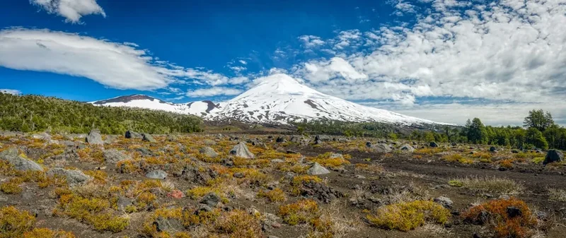
The Llaima Volcano Trail is a challenging yet immensely rewarding day hike located within the spectacular Conguillío National Park in Chile's Araucanía Region. This trail offers an unparalleled opportunity to ascend a dormant volcano, traversing diverse landscapes from ancient Araucaria (monkey puzzle) forests to stark volcanic scree and lava fields, culminating in breathtaking panoramic views from the volcano's rim. Conguillío National Park itself is a UNESCO World Biosphere Reserve, renowned for its dramatic volcanic scenery, vibrant turquoise lakes, and exceptionally well-preserved ancient forests, making the Llaima Volcano hike a highlight of any visit to the region.
- Distance: 12.0 km (round trip)
- Elevation Gain: 900 m
- Duration: 6–8 hours
- Difficulty: Challenging
- Season: November to March (Chilean summer)
- Closest City: Temuco
- Trailhead Access: Via Conguillío National Park
Overview
The Llaima Volcano Trail is a demanding ascent that rewards hikers with an extraordinary geological and ecological experience. Starting from the lower slopes, the trail immediately immerses you in the unique beauty of Conguillío National Park. You'll walk through dense forests of Araucaria araucana, trees that are ancient, resilient, and iconic to this region, their distinctive umbrella-like canopies creating a surreal, almost prehistoric atmosphere. As you gain altitude, the forest gradually thins, giving way to more open terrain characterized by volcanic rock, ash, and sparse vegetation adapted to harsh conditions.
The climb is steep and relentless, with significant elevation gain packed into a relatively short distance. This requires a good level of physical fitness and stamina. The trail surface varies, from well-trodden paths in the forest to loose scree and rocky sections higher up, demanding careful footing. The final push to the summit crater involves navigating volcanic scree, which can be challenging but offers a tangible sense of accomplishment.
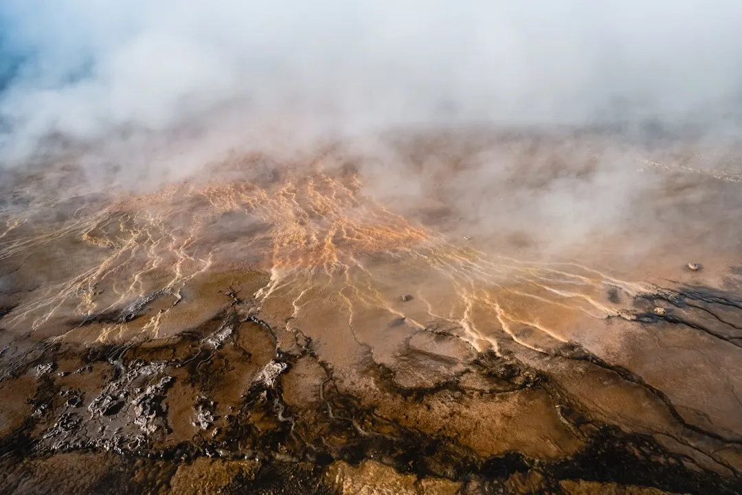
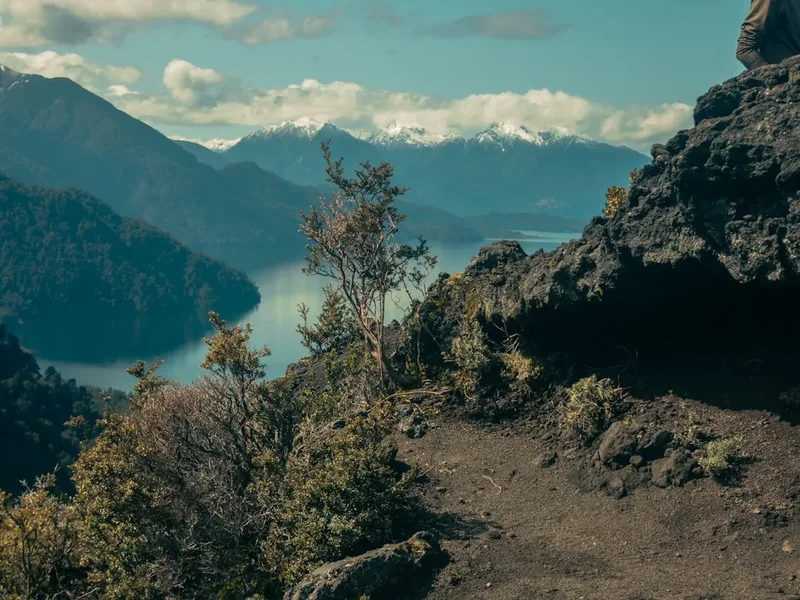
Upon reaching the rim of the Llaima Volcano's crater, the views are simply spectacular. On a clear day, you are treated to a 360-degree panorama encompassing the vast expanse of Conguillío National Park, with its shimmering turquoise lakes (like Laguna Verde and Laguna Conguillío), the surrounding mountain ranges, and other volcanoes in the distance, including the imposing Volcán Villarrica. The stark beauty of the volcanic landscape, shaped by past eruptions, is a powerful reminder of the earth's dynamic forces. The descent offers a different perspective on the terrain, allowing you to appreciate the scale of the volcano and the resilience of the flora that colonizes its slopes.
This hike is not just about the summit; it's about the journey through a unique ecosystem and a dramatic geological landscape. It’s a challenging day walk that offers a profound connection with nature and a deep appreciation for the raw power and beauty of volcanic environments.
History and Geological Context
Llaima Volcano is one of Chile's most active volcanoes, with a history of frequent eruptions spanning centuries. Its last significant eruption occurred in 2008, which led to temporary closures of Conguillío National Park. The volcano's activity has profoundly shaped the landscape of the surrounding region, creating the dramatic terrain that hikers now explore. The park itself was established in 1959 to protect these unique volcanic and forest ecosystems.
The Araucaria araucana, or monkey puzzle tree, found in abundance along the lower sections of the trail, is a species of ancient lineage, predating the dinosaurs. These trees are culturally significant to the indigenous Mapuche people, who have long inhabited this region. They hold spiritual importance and their seeds (piñones) have historically been a vital food source. The presence of these ancient forests, alongside the active volcanic geology, creates a unique ecological and cultural tapestry.
The trail itself is a testament to the park's efforts to provide access to these remarkable natural features while managing visitor impact. The development of trails like the Llaima Volcano hike allows people to experience the raw power of volcanic landscapes and the unique biodiversity of the Araucanía region, fostering an appreciation for conservation and geological wonders.
Seasonal Highlights and Weather Considerations
The Llaima Volcano Trail is best experienced during the Chilean summer, from November to March. This period offers the most favourable weather conditions for hiking, with longer daylight hours and generally milder temperatures.
Summer (November to March): This is the prime hiking season. Days are typically sunny and warm, with temperatures ranging from 15°C to 25°C. The Araucaria forests are lush, and the views from the summit are often clearest. However, even in summer, mountain weather can be unpredictable. Be prepared for sudden changes, including strong winds, rain showers, and a significant drop in temperature at higher altitudes. Sandflies can be present, especially near water sources and during warmer, humid conditions.
Spring (September to October) and Autumn (April to May): These shoulder seasons can offer beautiful scenery with fewer crowds. However, weather is more variable. Snow may still linger on the upper slopes in early spring, and early snowfalls can occur in autumn. Temperatures will be cooler, and daylight hours shorter. Access to the trailhead might also be affected by road conditions after winter.
Winter (June to August): Conguillío National Park experiences significant snowfall during winter, and the Llaima Volcano Trail is generally inaccessible and unsafe for hiking. Roads may be closed, and the volcano's upper slopes will be covered in snow and ice, requiring advanced mountaineering skills and equipment. This season is strictly for experienced winter mountaineers, if at all.
Weather on the Volcano: It is crucial to understand that weather conditions on Llaima Volcano can change rapidly and dramatically. Even on a clear morning, clouds can roll in quickly, reducing visibility to near zero and bringing strong winds and cold temperatures. Always check the forecast before you go and be prepared for all conditions.
Recommended Itinerary
Llaima Volcano Day Hike Itinerary
Early Morning (Approx. 7:00 AM - 8:00 AM): Departure from Base Town
- Depart from your accommodation in Temuco or a nearby town.
- Drive or take transport towards Conguillío National Park. The journey takes approximately 2 hours.
- Ensure you have sufficient fuel and supplies, as services are limited within the park.
Morning (Approx. 9:00 AM - 10:00 AM): Arrival at Conguillío National Park & Trailhead
- Enter Conguillío National Park. Pay entrance fees and register your hike if required.
- Drive to the designated Llaima Volcano trailhead parking area.
- Final gear check, apply sunscreen and insect repellent, and prepare for the hike.
- Begin the ascent from the trailhead.
Late Morning to Midday (Approx. 10:00 AM - 1:00 PM): Forested Ascent
- The initial part of the trail winds through dense Araucaria (monkey puzzle) forests.
- Enjoy the unique flora and fauna of this ancient ecosystem.
- The path is generally well-defined but can be uneven.
- Begin to notice the thinning of the forest as you gain elevation.
Afternoon (Approx. 1:00 PM - 3:00 PM): Volcanic Slopes and Summit Approach
- Transition from forest to open volcanic terrain.
- The trail becomes steeper and may involve navigating scree and loose rock.
- Take breaks to admire the changing landscape and the increasingly expansive views.
- Reach the crater rim of Llaima Volcano.
Mid-Afternoon (Approx. 3:00 PM - 4:00 PM): Summit Exploration and Lunch
- Explore the rim of the volcano's crater.
- Enjoy a packed lunch while taking in the breathtaking 360-degree panoramic views.
- Identify surrounding landmarks such as Laguna Verde, Laguna Conguillío, and other volcanoes.
- Spend time appreciating the stark beauty of the volcanic landscape.
Late Afternoon (Approx. 4:00 PM - 6:00 PM): Descent
- Begin the descent back down the volcano.
- Exercise caution on the scree and rocky sections, as the descent can be challenging on the knees.
- Re-enter the Araucaria forest as you get lower.
Evening (Approx. 6:00 PM - 7:00 PM): Return to Trailhead and Departure
- Arrive back at the trailhead parking area.
- Change into dry clothes, rehydrate, and reflect on the day's achievement.
- Depart from Conguillío National Park.
Important Notes:
- This is a challenging hike; ensure you are physically prepared.
- Carry ample water and high-energy food.
- Weather can change rapidly; pack layers and full waterproofs.
- Start early to allow ample time and avoid afternoon weather changes.
- Check park opening times and any specific trail regulations before your visit.
Planning and Bookings
Book Your Trip
Everything you need to plan your journey
Accommodation
Find places to stay near Temuco
Flights
Search flights to Temuco
Essential Preparation
The Llaima Volcano Trail is a day hike within Conguillío National Park. The primary planning involves ensuring access to the park and being prepared for a challenging mountain environment. The closest major city is Temuco, which offers a full range of services, including accommodation, car rentals, and outdoor gear shops. From Temuco, it's approximately a 2-hour drive to the park entrance. Roads within the park can be unpaved and may require a 4x4 vehicle, especially after rain or during shoulder seasons; always check current road conditions before your trip.
It is essential to check the official website of CONAF (Corporación Nacional Forestal), the Chilean National Forest Corporation, for the latest information on park access, opening hours, fees, and any specific regulations or alerts related to the Llaima Volcano Trail. While no specific booking is usually required for day hikers to access the trail itself, park entrance fees apply, and it's wise to confirm if any registration is necessary, especially during peak season.
Trail Accommodation
This is a day hike requiring no overnight accommodation.
Required Gear
- Sturdy hiking boots: Waterproof and with good ankle support, broken in to prevent blisters.
- Backpack: A daypack (20-30 litres) to carry essentials.
- Waterproof jacket and trousers: Essential for protection against rain and wind, which can change rapidly at altitude.
- Warm layers: Fleece or down jacket, thermal base layers, hat, and gloves. Temperatures can be significantly colder at the summit than at the trailhead.
- Navigation: Map of Conguillío National Park, compass, and/or a GPS device or smartphone with offline maps. Mobile signal is unreliable.
- Head torch: With spare batteries, in case of unexpected delays.
- Sun protection: High SPF sunscreen, sunglasses, and a wide-brimmed hat. The sun can be intense, especially at higher altitudes.
- First-aid kit: Including blister treatment, pain relievers, antiseptic wipes, and any personal medications.
- Trekking poles: Highly recommended for stability on steep ascents and descents, especially on scree.
What to Bring
- Water: At least 2-3 litres per person. There are no reliable water sources on the upper parts of the trail.
- Food: High-energy snacks and a packed lunch. Consider items like nuts, dried fruit, energy bars, sandwiches, and chocolate.
- Insect repellent: Especially important during warmer months to ward off sandflies.
- Toilet paper and a small trowel: For emergencies, and a bag to pack out all waste.
- Camera: To capture the stunning scenery.
- Personal identification and park entrance fee payment.
Permits
Access to Conguillío National Park requires an entrance fee. This fee is typically paid at the park's main entrance stations. For the Llaima Volcano Trail specifically, no separate permit is usually required for day hikers, beyond the general park entrance. However, it is always advisable to check the official CONAF website for Conguillío National Park for the most up-to-date information regarding fees, opening hours, and any specific regulations or advisories that may be in place.
Park Entrance Fees: Fees vary and are subject to change. It is recommended to have Chilean Pesos (CLP) available for payment, although some park offices may accept credit cards. Check the CONAF website for current pricing.
Registration: In some cases, especially during peak season or if specific safety concerns are raised, park rangers may require hikers to register their intended route at the visitor centre or trailhead. This helps with search and rescue efforts if needed.
Seasonal Access: While the park is generally open year-round, access to certain areas, including the Llaima Volcano trailhead, can be restricted during winter months due to snow and road conditions. Always confirm accessibility before your visit.
Other Activities in the Area
Conguillío National Park and its surroundings offer a wealth of activities for nature enthusiasts:
- Laguna Verde and Laguna Conguillío: Explore the shores of these stunning turquoise lakes. Short walking trails offer different vantage points and opportunities for photography.
- Arboretum de Chile: Discover a diverse collection of native and exotic trees, showcasing the region's rich botanical heritage.
- Sierra Nevada Trail: A longer, more challenging hike offering spectacular views of the park's lakes and volcanoes.
- Picnic areas and viewpoints: Numerous designated spots throughout the park provide excellent locations for relaxation and enjoying the scenery.
- Wildlife viewing: Keep an eye out for native birds, including the Magellanic woodpecker, and other small mammals that inhabit the park.
- Photography: The dramatic volcanic landscapes, ancient forests, and vibrant lakes provide endless opportunities for stunning photographs.
- Exploring nearby towns: Visit towns like Curacautín or Malalcahuello for local culture, crafts, and regional cuisine.
Safety and Conditions
Pre-Hike Checks:
- Weather Forecast: Always check the most up-to-date weather forecast for Conguillío National Park and specifically for the Llaima Volcano area. Mountain weather can change rapidly.
- Park Conditions: Visit the CONAF website or contact the park office for information on trail conditions, road access, and any alerts or closures.
- Road Conditions: If driving, be aware that park roads can be unpaved, rough, and may require a 4x4 vehicle, especially after rain or during shoulder seasons.
On the Trail:
- Physical Fitness: The Llaima Volcano Trail is a challenging hike with significant elevation gain. Ensure you are physically prepared for a sustained climb over 6-8 hours.
- Navigation: While the trail is generally well-marked, it is essential to carry a map and compass or GPS device. Do not rely solely on mobile phone signal, as it is often unavailable.
- Water and Food: Carry sufficient water (at least 2-3 litres per person) and high-energy food. There are no facilities for refilling water or purchasing food on the trail.
- Altitude and Temperature: Be prepared for cooler temperatures and stronger winds at higher elevations. Hypothermia is a risk, even in summer. Wear appropriate layers and carry waterproof and windproof gear.
- Volcanic Terrain: The upper sections of the trail involve loose scree and volcanic rock. Wear sturdy hiking boots and use trekking poles for stability. Be mindful of unstable footing.
- Sandflies: Sandflies can be present, particularly during warmer, humid conditions. Use effective insect repellent and cover exposed skin when stationary.
- Emergency Contact: Inform someone of your hiking plans, including your expected return time. Consider carrying a personal locator beacon (PLB) if hiking alone or in remote areas.
- Respect the Environment: Stay on marked trails to protect fragile vegetation and volcanic formations.
Emergency Procedures: In case of an emergency, contact park rangers or the relevant emergency services. Know the park's emergency contact numbers before you start your hike.
Side Trips and Points of Interest
While the Llaima Volcano summit is the primary objective, several points of interest and potential short side trips enhance the experience:
Crater Rim Exploration: Upon reaching the summit, take time to carefully explore the rim of the volcano's crater. Observe the geological formations, the stark beauty of the volcanic rock, and the vastness of the caldera. Always maintain a safe distance from the crater edge.
Panoramic Viewpoints: The entire ascent offers increasingly spectacular viewpoints. Pause at various points to admire the changing perspectives of the Araucaria forests, the turquoise lakes below (Laguna Verde, Laguna Conguillío), and the surrounding volcanic peaks like Villarrica and Quetrupillán.
Geological Features: Observe the diverse volcanic rock types, lava flows, and ash deposits that characterize the landscape. These features tell the story of Llaima's eruptive history.
Flora and Fauna: Pay attention to the transition zones between the dense Araucaria forests and the more sparse alpine vegetation. Look for native birds and other wildlife that have adapted to this unique environment.
Leave No Trace
The Llaima Volcano Trail traverses a sensitive and geologically significant environment within Conguillío National Park, a UNESCO World Biosphere Reserve. Adhering to Leave No Trace principles is crucial to preserving this unique landscape for future generations.
Plan Ahead and Prepare: Research the trail, understand its challenges, and be prepared for all weather conditions. Pack appropriately and know the park regulations.
Travel and Camp on Durable Surfaces: Stay on the marked trail at all times. The vegetation, especially the delicate mosses and lichens, can take years to recover if trampled. The volcanic scree is also best navigated on established paths.
Dispose of Waste Properly: Pack out everything you pack in. This includes all food scraps, wrappers, and any other litter. Use designated toilet facilities where available, or if necessary, dig a cathole at least 60 metres away from water sources, trails, and campsites, and bury human waste. Pack out all toilet paper.
Leave What You Find: Do not remove rocks, plants, or any natural or cultural artifacts. Take only photographs and memories.
Minimize Campfire Impacts: Campfires are generally not permitted on this day hike. If you were to camp in designated areas (not applicable for this trail), use established fire rings and keep fires small.
Respect Wildlife: Observe wildlife from a distance. Never feed animals, as it can harm their health, alter their natural behaviours, and expose them to predators or human-related dangers.
Be Considerate of Other Visitors: Keep noise levels down, yield to other hikers on narrow sections, and maintain a respectful attitude towards fellow visitors and the natural environment.