Limmernsee Hike - A Swiss Alpine Gem
The Limmernsee Hike is a spectacular day walk in the heart of the Swiss Alps, offering breathtaking views and a rewarding challenge. This route takes you high above the Limmerensee reservoir, providing panoramic vistas of rugged peaks, deep valleys, and the striking turquoise waters of the lake itself. It's a journey that combines accessible alpine scenery with a genuine sense of mountain adventure, making it a must-do for hikers visiting the Glarus region.
- Distance: 18.5 km one-way
- Elevation Gain: 950 m
- Duration: 6–8 hours
- Difficulty: Moderate
- Season: June to October (for snow-free conditions)
- Closest City: Linthal
- Trailhead Access: Nearest airport: Zurich (ZRH). Take train to Linthal, then bus to Tierfehd (Limmernbahn). By car: drive to Tierfehd. Parking available at Limmernbahn. Road is paved. Take the Limmernbahn cable car from Tierfehd to Kalktrittli. No permit needed.
- Coordinates: 46.8215, 8.9228
Overview
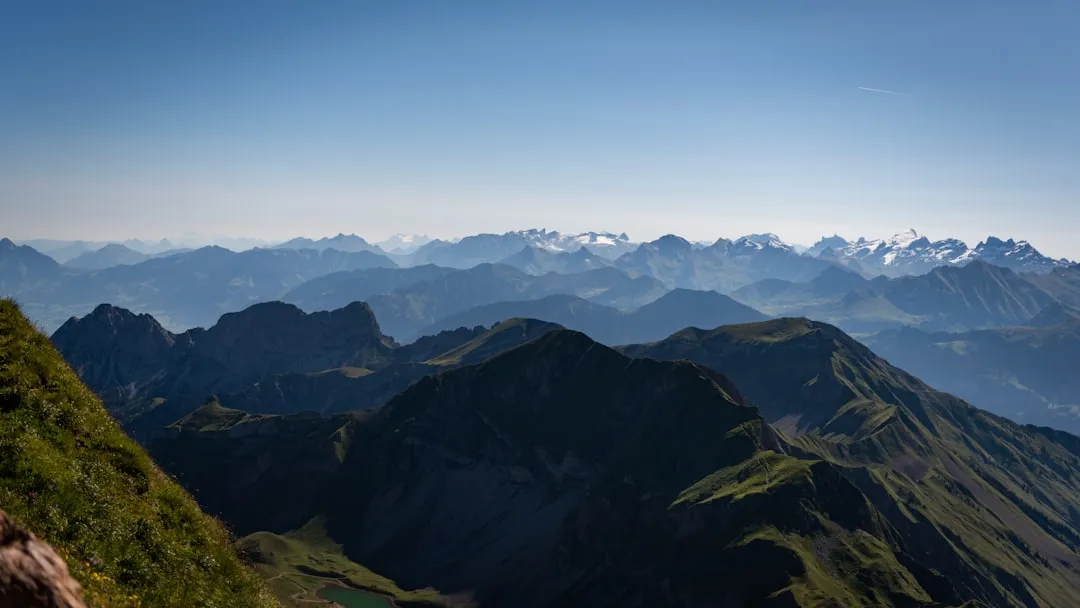
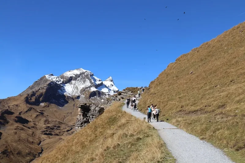
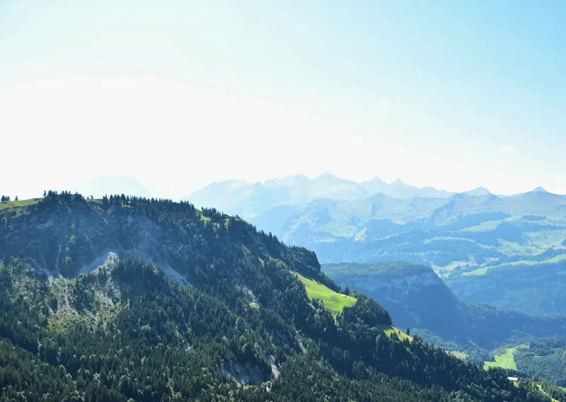
The Limmernsee Hike is a testament to the dramatic beauty of the Swiss Alps. Starting from the high-altitude Kalktrittli station, accessible via the Limmernbahn cable car, the trail immediately immerses you in a rugged, mountainous environment. The path winds its way around the vast Limmerensee reservoir, a man-made lake whose vibrant turquoise hue contrasts sharply with the surrounding grey rock and green alpine meadows. This is not a gentle stroll; the trail involves significant elevation changes, including a substantial climb to the highest point of the hike, offering unparalleled views across the Glarus Alps.
The route is characterised by its varied terrain. You'll traverse well-maintained gravel paths, rocky sections, and potentially some steeper, more exposed areas, especially as you ascend towards the higher viewpoints. The landscape is sculpted by glaciers and time, with dramatic rock formations, scree slopes, and patches of resilient alpine flora. The air is crisp and clean, and the silence is broken only by the wind, the distant bleating of sheep, or the call of a mountain bird.
This hike is particularly rewarding for its accessibility to such a high alpine environment. The cable car significantly reduces the initial ascent, allowing hikers to reach the heart of the alpine scenery within a reasonable timeframe. The panoramic views from the higher sections of the trail are truly spectacular, encompassing a vast expanse of peaks, valleys, and the shimmering reservoir below. It’s a day of immersion in raw, untamed mountain nature, offering a profound sense of accomplishment upon completion.
History and Context
The Glarus Alps, where the Limmernsee Hike is situated, have a long history of human interaction, primarily driven by resource extraction and pastoralism. For centuries, these mountains provided grazing land for livestock, and the construction of reservoirs like the Limmerensee in the 20th century reflects the region's importance for hydroelectric power generation. The infrastructure, including the Limmernbahn cable car, is a modern testament to the engineering required to harness the power of these alpine environments.
The development of hiking trails in Switzerland is deeply rooted in the country's tradition of mountaineering and tourism. The paths you walk on are often ancient routes used by shepherds and farmers, or they have been specifically developed to allow access to scenic viewpoints and natural wonders. The Limmernsee Hike benefits from this well-established network of marked trails, ensuring a safe and enjoyable experience for hikers of varying abilities.
While not steeped in ancient Māori history like the Milford Track, the Glarus region has its own rich cultural heritage. The canton of Glarus is known for its distinctive dialect, its historical independence, and its contributions to Swiss industry and politics. The presence of the reservoir itself signifies a modern chapter in the region's history, one where natural resources are managed for energy production, yet the landscape's inherent beauty is preserved and made accessible for recreation.
Seasonal Highlights and Weather Considerations
The Limmernsee Hike is best undertaken during the warmer months, typically from June to October. During this period, the snow has generally melted from the higher trails, making them safe and accessible. The alpine meadows are often in bloom, adding vibrant colours to the already stunning scenery.
Summer (June to August): This is the peak season for hiking in the Swiss Alps. The weather is generally warmer, and the days are long, providing ample time for the hike. However, summer can also bring thunderstorms, particularly in the afternoons. It's crucial to start your hike early in the morning to avoid the worst of the weather and the crowds.
Autumn (September to October): This season offers crisp, clear air and spectacular autumn colours in the lower valleys. The crowds tend to be smaller, and the temperatures are cooler, making for comfortable hiking conditions. However, the risk of early snowfall increases as the season progresses, especially at higher elevations. Always check the weather forecast before heading out.
Winter (November to May): The Limmernsee Hike is generally not feasible during winter due to heavy snowfall and avalanche risk. The cable car may also operate on a reduced schedule or be closed entirely. This period is for experienced winter mountaineers only, with appropriate gear and knowledge.
Weather Reality: Alpine weather is notoriously unpredictable. Even in summer, conditions can change rapidly. Be prepared for all types of weather, including sunshine, rain, wind, and even snow, regardless of the season. Layering clothing is essential.
Recommended Itinerary
Limmernsee Hike - Day Walk Itinerary
Early Morning: Travel to Tierfehd and Cable Car Ascent
- Travel by train and bus, or by car, to Tierfehd.
- Locate the Limmernbahn cable car station.
- Purchase tickets and board the cable car for the scenic ascent to Kalktrittli.
- The cable car ride itself offers impressive views as you gain altitude.
- Estimated time: 1–2 hours (depending on travel from accommodation)
Morning: Begin the Hike from Kalktrittli
- Arrive at Kalktrittli station (approx. 1,850 m).
- Take a moment to acclimatise and admire the initial views.
- Begin the hike, following the well-marked trail towards the Limmerensee reservoir.
- The initial section involves a moderate descent and then a gradual traverse.
- You will soon catch your first glimpses of the striking turquoise waters of the reservoir.
- Distance covered: Approximately 4–5 km
- Estimated time: 1.5–2 hours
Midday: Traverse the Reservoir and Ascend to Higher Ground
- Continue along the path that skirts the edge of the Limmerensee.
- The trail may involve some rocky sections and ascents/descents as it navigates the terrain.
- Look for opportunities to stop and take photographs of the reservoir and surrounding peaks.
- As you move away from the immediate vicinity of the reservoir, the trail begins to ascend more noticeably.
- This section offers increasingly expansive views of the alpine landscape.
- Distance covered: Approximately 5–6 km
- Estimated time: 2–2.5 hours
Afternoon: Reach Highest Viewpoints and Begin Descent
- The trail reaches its highest points, offering commanding panoramic views.
- This is an excellent spot for a picnic lunch and to soak in the grandeur of the Glarus Alps.
- Identify prominent peaks and valleys from your vantage point.
- Begin the descent, retracing your steps or following a slightly varied route if available and clearly marked.
- The descent can be steep in places, so take care with your footing.
- Distance covered: Approximately 7–8 km
- Estimated time: 2.5–3 hours
Late Afternoon: Return to Kalktrittli and Cable Car Descent
- Continue your descent back towards the Kalktrittli cable car station.
- Ensure you have ample time to catch the last cable car down. Check operating times in advance.
- Board the Limmernbahn cable car for the return journey to Tierfehd.
- Reflect on the day's incredible alpine experience.
- Estimated time: 1–1.5 hours (including cable car ride)
Important Notes:
- Check the operating hours of the Limmernbahn cable car before your trip.
- Wear sturdy hiking boots with good ankle support.
- Carry plenty of water and snacks, as facilities are limited on the trail.
- Be prepared for rapidly changing weather conditions.
- The trail is well-marked, but carrying a map or using a GPS device is advisable.
Planning and Bookings
Book Your Trip
Everything you need to plan your journey
Accommodation
Find places to stay near Linthal
Flights
Search flights to Linthal
Essential Preparation
The Limmernsee Hike is a day walk, meaning accommodation is not a primary concern on the trail itself. However, planning your travel to the trailhead and understanding the logistics of the Limmernbahn cable car are crucial. The nearest major city with comprehensive transport links is Zurich. From Zurich, you can take a train to Linthal, which is the gateway town to the region. From Linthal, a local bus service will take you to Tierfehd, the base station for the Limmernbahn cable car.
If travelling by car, you can drive directly to Tierfehd. There is parking available at the cable car station. The road leading to Tierfehd is paved and generally in good condition. It's advisable to check local road conditions, especially if travelling outside the main summer season.
Understanding the operating schedule of the Limmernbahn cable car is paramount. It typically runs during the summer months and may have limited hours, especially at the beginning and end of its operating season. Always verify the current schedule online or by contacting the cable car operator before your visit.
Trail Accommodation
This is a day hike requiring no overnight accommodation.
Required Gear
- Hiking Boots: Sturdy, waterproof hiking boots with good ankle support are essential for navigating the varied terrain, which can include rocky paths and uneven ground.
- Waterproof Jacket: A reliable waterproof and windproof jacket is crucial, as alpine weather can change rapidly, bringing rain and strong winds.
- Waterproof Overtrousers: Recommended for protection against rain and wind, especially during prolonged periods of inclement weather.
- Backpack: A comfortable daypack (20–30 litres) to carry your essentials, including water, food, extra layers, and safety equipment.
- Navigation Tools: A map of the area, a compass, and/or a GPS device or smartphone with offline maps are highly recommended. While the trail is generally well-marked, it's wise to be prepared.
- First Aid Kit: A basic first aid kit including plasters, antiseptic wipes, pain relievers, and any personal medications.
- Sun Protection: High-factor sunscreen, sunglasses, and a wide-brimmed hat are important, as the sun can be intense at higher altitudes, even on cloudy days.
- Head Torch: A head torch with spare batteries is advisable, in case your hike takes longer than expected and you are descending in low light conditions.
What to Bring
- Food: Plenty of high-energy snacks and a packed lunch. There are no food services along the trail.
- Water: At least 2 litres of water per person. Water sources may be available, but it is strongly recommended to treat any water collected from natural sources using a filter or purification tablets.
- Extra Layers: A warm fleece or insulated jacket, and a warm hat and gloves, even in summer, as temperatures can drop significantly at higher elevations or with wind chill.
- Mobile Phone: Fully charged, for emergency use. Note that mobile signal may be intermittent in mountainous areas.
- Trekking Poles: Optional, but can be very helpful for stability on ascents and descents, and for reducing strain on knees.
- Camera: To capture the stunning alpine scenery.
- Small Towel: Useful if you encounter any water sources or for wiping sweat.
Permits

No specific permits are required for the Limmernsee Hike. The trail is part of the public hiking network in Switzerland, and access to the area is generally free. The primary requirement for accessing the trailhead is the use of the Limmernbahn cable car, for which a ticket must be purchased.
Limmernbahn Cable Car:
- Tickets can be purchased at the base station in Tierfehd.
- Prices vary depending on whether you are purchasing a single journey or a return ticket. It is advisable to purchase a return ticket for convenience.
- Check the official website of the Limmernbahn for current pricing and operating hours. Discounts may be available for children, seniors, or groups.
Important Considerations:
- While no permit is needed for the hike itself, always respect the natural environment and follow local guidelines.
- Ensure you are adequately prepared for the conditions, as rescue services may be limited and costly if you are unprepared.
- The area is managed by local authorities and energy companies; be mindful of any signage or restrictions related to the reservoir or surrounding infrastructure.
Other Activities in the Area
The Glarus region offers a wealth of activities for outdoor enthusiasts, complementing the Limmernsee Hike:
- Skiing and Snowboarding: During winter, the nearby Braunwald and Elm ski resorts offer excellent opportunities for winter sports.
- Via Ferrata: For the more adventurous, the Glarus region boasts several challenging Via Ferrata routes, allowing you to climb steep rock faces with the aid of steel cables and ladders.
- Other Hiking Trails: Numerous other hiking trails exist in the Glarus Alps, ranging from gentle valley walks to demanding multi-day treks. Explore routes around the nearby Klöntalersee or venture further into the mountains.
- Mountain Biking: Designated mountain bike trails offer thrilling descents and scenic rides through alpine landscapes.
- Paragliding and Hang Gliding: The mountainous terrain and thermal conditions make the Glarus region a popular spot for paragliding and hang gliding enthusiasts.
- Cultural Exploration: Visit the charming villages of the Glarus region, such as Glarus itself, with its historic buildings and museums, or explore the traditional architecture of smaller hamlets.
- Swimming and Water Sports: In warmer months, lakes like Klöntalersee offer opportunities for swimming and other water activities.
Safety and Conditions
Pre-Hike Checks:
- Weather Forecast: Always check the most up-to-date mountain weather forecast for the Glarus region before you set out. Websites like MeteoSwiss or local alpine club forecasts are invaluable.
- Trail Conditions: While the Limmernsee trail is generally well-maintained, conditions can change. Look for recent reports from local tourist offices or hiking forums if available. Be aware of potential snow patches early or late in the season.
- Cable Car Status: Confirm the operating hours and any potential disruptions for the Limmernbahn cable car.
On the Trail:
- Navigation: Stick to marked trails. While the main route is clear, it's easy to get disoriented in fog or poor visibility. Carry a map and compass and know how to use them.
- Altitude: The hike reaches significant altitudes. Be aware of the symptoms of altitude sickness, although for a day hike of this nature, it is less common unless you ascend very rapidly or have pre-existing conditions.
- Terrain: The trail can be rocky, uneven, and steep in places. Wear appropriate footwear and take your time, especially on descents.
- Weather Changes: Be prepared for rapid shifts in weather. Hypothermia is a risk even in summer if you get wet and cold. Always carry extra layers.
- Water: Carry sufficient water. While streams may be present, it's best to treat water from natural sources.
- Emergency Contact: Inform someone of your hiking plans, including your intended route and expected return time. Save emergency numbers (Swiss emergency number is 144) on your phone.
- Wildlife: While large dangerous animals are rare, be aware of your surroundings. Respect any wildlife you encounter and maintain a safe distance.
Rescue Services: In case of an emergency, contact the Swiss emergency number (144). Be prepared to give your exact location. Rescue operations in remote alpine areas can be complex and time-consuming.
Side Trips and Points of Interest
Limmerensee Reservoir Views: The primary point of interest is the reservoir itself. Its striking turquoise colour, a result of glacial silt suspended in the water, is a photographer's dream. The scale of the reservoir, surrounded by imposing mountain peaks, creates a dramatic and memorable landscape. Take time to find different vantage points along the trail to appreciate its beauty from various angles.
Kalktrittli Station Views: The starting and ending point of the hike, Kalktrittli, offers an immediate reward with expansive views. From here, you can often see across to other prominent peaks and valleys in the Glarus region. It's a great spot for initial orientation and a final appreciation of the alpine panorama before descending.
Alpine Flora and Fauna: Keep an eye out for the resilient plant life that thrives in the alpine environment. Depending on the season, you might see colourful wildflowers, hardy grasses, and mosses clinging to rocks. Birdlife is also present, and you might spot chamois or ibex in the more remote areas, though they are often shy.
Geological Formations: The landscape is a result of millions of years of geological activity. Observe the rock formations, scree slopes, and the evidence of glacial erosion that have shaped the dramatic topography of the Glarus Alps.
Leave No Trace
The Limmernsee Hike traverses a pristine alpine environment. Adhering to Leave No Trace principles is essential to preserve its beauty and ecological integrity for future visitors.
Plan Ahead and Prepare: Understand the trail, weather, and any specific regulations before you go. Pack appropriately for the conditions.
Travel and Camp on Durable Surfaces: Stay on the marked trails. Avoid walking on fragile alpine meadows or disturbing vegetation. The trail itself is the designated durable surface.
Dispose of Waste Properly: Pack out everything you pack in. This includes all food scraps, wrappers, and any other litter. Use designated toilet facilities where available, or if not, dig a cathole at least 60 metres away from water sources, trails, and campsites, and bury human waste.
Leave What You Find: Do not take rocks, plants, or any other natural objects. Leave them for others to enjoy.
Minimise Campfire Impacts: Campfires are generally not permitted on day hikes and are not relevant to this trail. If camping were permitted, use established fire rings and keep fires small.
Respect Wildlife: Observe wildlife from a distance. Do not feed animals, as this can harm their health and alter their natural behaviours.
Be Considerate of Other Visitors: Keep noise levels down and yield to other hikers. Respect the peaceful nature of the alpine environment.