Lauterbrunnen to Mürren - The Vertical Heart of the Bernese Oberland
The hike from Lauterbrunnen to Mürren is a quintessential Swiss alpine experience, a journey that ascends from the depths of a dramatic U-shaped glacial valley to a sun-drenched terrace perched high above the world. Lauterbrunnen, often referred to as the "Valley of 72 Waterfalls," serves as the starting point for this 6.5-kilometre ascent. The trail is a masterclass in vertical geography, climbing 800 metres through dense spruce forests, across rushing mountain streams, and eventually onto the high alpine meadows that define the Jungfrau region. As you climb, the perspective shifts from the intimate, mossy details of the valley floor to the staggering, panoramic scale of the "Big Three": the Eiger, Mönch, and Jungfrau peaks, which dominate the eastern horizon with their permanent glaciers and sheer limestone faces.
This is not merely a walk; it is a transition between two distinct worlds. Below lies the bustling valley floor, where the White Lütschine river carves its way through the limestone. Above lies Mürren, a car-free village that feels suspended in time, accessible only by foot or cable car. The trail follows a historic route used for centuries by local farmers to move livestock to higher pastures, a tradition known as transhumance that continues to shape the landscape today. Whether you are seeking a physical challenge, a photographic odyssey, or a deep connection with the geological history of the Alps, the Lauterbrunnen to Mürren trail delivers an unparalleled sensory experience in one of the most photographed landscapes on Earth.
- Distance: 6.5 km one-way
- Duration: 2.5–3.5 hours (ascent)
- Elevation Gain: 800 m
- Difficulty: Moderate (steep but well-maintained)
- Highest Point: Mürren (1,638 m)
- Trailhead: Lauterbrunnen Railway Station (795 m)
- Best Time: June to September (wildflowers and clear skies)
Overview
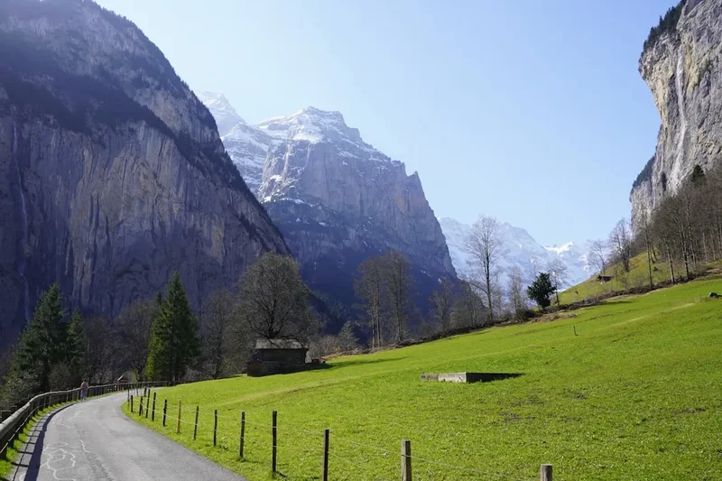
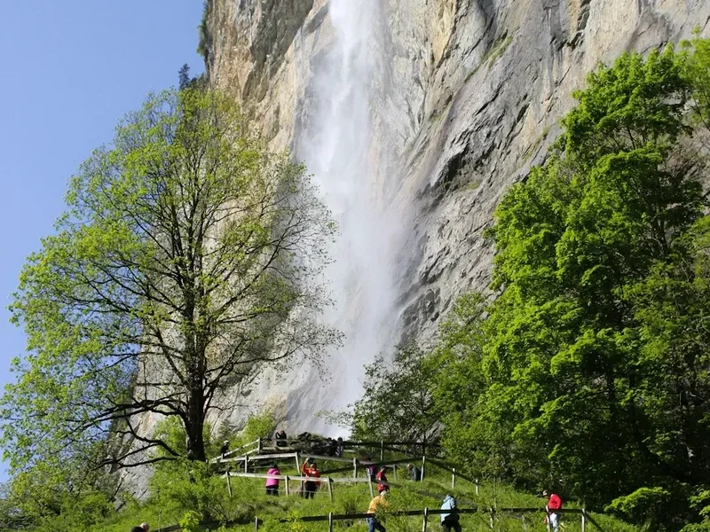
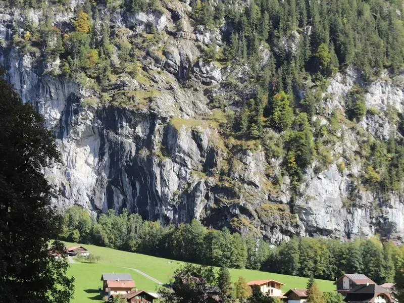
The Lauterbrunnen to Mürren trail is a classic "ascent hike" that rewards every drop of sweat with increasingly dramatic vistas. The route begins in the village of Lauterbrunnen, situated at 795 metres above sea level. The valley itself is a geological marvel, formed during the last ice age when massive glaciers carved through the limestone plateau, leaving behind vertical walls that rise up to 1,000 metres on either side. This unique topography is responsible for the valley's famous waterfalls, most notably the Staubbach Falls, which plunges nearly 300 metres just a short distance from the trailhead. The first half of the hike is a steady, demanding climb through the forest, where the air is cool and scented with pine and damp earth. This section is characterised by wide, well-graded gravel paths that zigzag up the western wall of the valley.
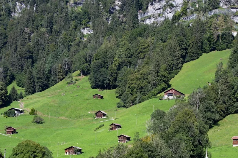
As the trail gains elevation, the forest begins to thin, revealing the first glimpses of the Bernese Alps across the valley. The transition from the shaded forest to the open alpine meadows near Winteregg is one of the highlights of the journey. Here, the gradient levels off slightly, and the path meanders through pastures where the sound of traditional Swiss cowbells provides a constant, melodic soundtrack. The final stretch into Mürren is a gentle traverse along the mountain terrace, offering uninterrupted views of the Schwarzmönch and the massive glaciers of the Jungfrau. Mürren itself, sitting at 1,638 metres, is the highest continuously inhabited village in the Canton of Bern, providing a perfect finish line with its traditional dark-wood chalets and flower-filled balconies.
While many tourists choose to take the cable car and mountain railway (the BLM) to reach Mürren, walking the route provides a sense of scale and accomplishment that mechanical transport cannot replicate. You feel the change in air pressure, notice the shift in vegetation from deciduous trees to hardy alpine flora, and experience the silence of the mountains that is often lost in the more crowded tourist hubs. The trail is well-marked with the iconic yellow Swiss hiking signs, ensuring that even those new to alpine trekking can navigate with confidence. It is a hike of contrasts: the power of the waterfalls, the stillness of the forest, and the overwhelming majesty of the high peaks.
History and Cultural Context
The history of the Lauterbrunnen Valley and the village of Mürren is a tapestry of rugged mountain survival and the birth of modern alpine tourism. For centuries, the valley was home to isolated farming communities who lived according to the rhythms of the seasons. The name "Lauterbrunnen" translates to "many springs" or "clear springs," a nod to the 72 waterfalls that cascade from the surrounding cliffs. These waters were both a blessing and a curse, providing irrigation but also posing a constant threat of flooding and erosion. The farmers of the region developed a unique system of agriculture, moving their cattle from the valley floor to the high meadows (the "Alps") in the summer to take advantage of the nutrient-rich grass, a practice that is still celebrated today with the "Alpabzug" festivals in September.
In the 18th and 19th centuries, the region began to attract the attention of poets, writers, and early mountaineers. Johann Wolfgang von Goethe visited in 1779 and was so moved by the Staubbach Falls that he wrote his famous poem "Spirit Song over the Waters." Later, in 1911, a young J.R.R. Tolkien hiked through the Lauterbrunnen Valley; the sheer cliffs and misty waterfalls left such an impression on him that they became the primary inspiration for Rivendell, the elven sanctuary in his Middle-earth legendarium. The development of the Bergbahn Lauterbrunnen-Mürren (BLM) in 1891 marked the beginning of a new era, making the high terrace accessible to international visitors and transforming Mürren into a world-renowned resort. Despite this modernisation, Mürren has fiercely protected its car-free status, preserving the quiet, traditional atmosphere that first drew visitors over a century ago.
The region also holds a significant place in the history of winter sports. Sir Arnold Lunn, a British pioneer of downhill skiing, organised the first slalom race in Mürren in 1922. This heritage is still visible today, as Mürren remains a hub for both summer hiking and winter skiing. The trail you walk today follows the same paths used by those early pioneers, connecting the deep agricultural roots of the valley with the sophisticated alpine culture of the heights. Every stone wall and mountain hut along the route tells a story of human endurance and the enduring allure of the Swiss Alps.
Want more background? Read extended notes on history and cultural context → Learn more
Seasonal Highlights and Weather Reality
The hiking season for the Lauterbrunnen to Mürren trail typically runs from June to September, though the exact window depends on the previous winter's snowfall. During the peak summer months of July and August, the trail is at its most vibrant. The alpine meadows are a riot of colour, with wildflowers such as gentians, alpenrose, and edelweiss in full bloom. The weather is generally stable, with daytime temperatures in the valley ranging from 18°C to 25°C, though it is significantly cooler at the higher elevation of Mürren. Afternoon thunderstorms are common in the Alps, often rolling in quickly after a clear morning, so an early start is always recommended.
June is a particularly beautiful time to visit, as the waterfalls are at their maximum volume due to the melting snow from the higher peaks. However, some higher-altitude sections of the trail near Mürren may still have lingering snow patches early in the month. September offers the most stable weather and the clearest air, providing the best conditions for photography. The crowds of high summer begin to thin, and the first hints of autumn colour appear in the larch trees. The "Alpabzug," where the cows are brought down from the mountains decorated with flowers and large bells, usually takes place in mid-to-late September and is a cultural highlight not to be missed.
In the shoulder seasons of May and October, the trail can be hit-or-miss. May often sees the lower sections of the trail open, but the upper reaches may still be under snow or very muddy. October can provide stunning "Indian Summer" days with crisp air and golden light, but the risk of early snowfall increases significantly. From November to April, the trail is often covered in snow and is better suited for snowshoeing or winter walking, provided you have the correct equipment and check for avalanche risks. Regardless of the season, mountain weather is notoriously unpredictable; a sunny morning can turn into a cold, rainy afternoon in a matter of minutes, making proper layering and waterproof gear essential year-round.
Recommended Itinerary
Lauterbrunnen to Mürren Day Hike
Early Morning: The Valley Floor and Initial Ascent
- Start: Lauterbrunnen Railway Station (795 m)
- Distance: 0–2 km
- Elevation gain: 250 m
- Begin by walking south through the village of Lauterbrunnen, following signs for "Mürren" and "Grütschalp"
- Pass the iconic Lauterbrunnen church and catch your first close-up view of the Staubbach Falls
- The trail leaves the paved village road and enters the forest, beginning a series of steep switchbacks
- The path is wide and well-maintained gravel, but the gradient is consistent (12–15%)
- Enjoy the shade of the spruce and beech trees, which provide a cool microclimate even on warm mornings
Mid-Morning: The Forest Climb and Mountain Streams
- Distance: 2–4 km
- Elevation gain: 400 m
- Continue the ascent as the trail weaves higher up the valley wall
- Cross several small mountain streams that cascade down towards the Lütschine river below
- Look for the yellow hiking markers at every junction to ensure you stay on the path to Mürren via Winteregg
- The forest begins to change, with more hardy conifers appearing as you gain altitude
- Occasional clearings offer "window views" back down to the Lauterbrunnen valley floor, which looks increasingly miniature
- This is the most physically demanding section of the hike; maintain a steady pace and stay hydrated
Late Morning: Reaching the Terrace and Winteregg
- Distance: 4–5.5 km
- Elevation gain: 150 m
- The trail emerges from the dense forest onto the alpine terrace near Winteregg (1,578 m)
- The gradient levels off significantly, transitioning into a gentle traverse
- The "Big Three" (Eiger, Mönch, Jungfrau) come into full view across the valley, providing a staggering backdrop
- Pass through active alpine pastures; you will likely encounter Swiss cows grazing near the path
- Optional stop at the Winteregg restaurant for a coffee or a local cheese platter with a view
- The path now runs roughly parallel to the BLM mountain railway line
Midday: The Final Traverse into Mürren
- Distance: 5.5–6.5 km
- Elevation gain: 50 m
- The final 1.5 kilometres is a nearly flat, scenic walk into the village of Mürren
- The path is paved or hard-packed gravel, making for easy walking as you soak in the views
- Enter the north end of Mürren (1,638 m), passing traditional chalets and hotels
- Finish at the Mürren BLM station or continue through the village to the Schilthorn cable car station
- Celebrate your 800-metre ascent with lunch at one of the village's sun terraces
- Return to Lauterbrunnen via the cable car and train (BLM) or continue hiking down to Gimmelwald
Important Notes:
- The trail is an ascent; if you prefer a downhill walk, take the cable car to Grütschalp and walk to Mürren, then hike down to Lauterbrunnen (though this is hard on the knees)
- Water is available at several troughs along the way, but it is best to carry at least 1.5 litres
- The trail is shared with mountain bikers in some sections; stay to the right and be aware of your surroundings
- Check the BLM train schedule if you plan to take the train for part of the journey
Planning and Bookings
Book Your Trip
Everything you need to plan your journey
Accommodation
Find places to stay near Interlaken
Flights
Search flights to Interlaken
Essential Preparation
While the hike from Lauterbrunnen to Mürren is a day walk and does not require complex permits, preparation is key to an enjoyable experience. The primary requirement is a moderate level of fitness; an 800-metre vertical gain over 6.5 kilometres is a significant workout for those not accustomed to mountain hiking. It is recommended to spend at least one day in the valley (Interlaken or Lauterbrunnen) to acclimatise before attempting the ascent. Download the "MeteoSwiss" app for the most accurate local weather forecasts, as conditions in the Bernese Oberland can change rapidly.
Logistically, Lauterbrunnen is the central hub. It is easily reached by train from Interlaken Ost (20 minutes). If you are driving, there is a large multi-storey car park at the Lauterbrunnen station, though it fills up quickly in high season. Ensure you have a Swiss Travel Pass or a Half Fare Card if you plan on using the cable cars or trains for your return journey, as these provide significant discounts on the local transport network.
Trail Accommodation
As this is a day hike, overnight accommodation on the trail itself is not necessary, but there are excellent options at both the start and finish points. Staying in Mürren after your hike allows you to experience the village's famous "Alpenglow" when the peaks turn pink and orange at sunset.
Lauterbrunnen (Trailhead):
- Valley Hostel: A popular, high-quality budget option for hikers and backpackers.
- Hotel Staubbach: A historic hotel with direct views of the falls.
- Camping Jungfrau: Offers cabins and pitches at the base of the cliffs.
Mürren (Finish):
- Hotel Edelweiss: Perched on the edge of the cliff with spectacular views.
- Eiger Guesthouse: Located right across from the BLM station, offering a cosy, traditional atmosphere.
- Hotel Bellevue: A mid-range option with a great sun terrace.
- Note: Mürren is car-free; if you stay here, your luggage must be transported via the cable car.
Required Gear
- Hiking Boots: Sturdy boots with good ankle support and a lugged sole (Vibram or similar) are essential for the steep, gravelly sections.
- Waterproof Jacket: A lightweight, breathable shell (Gore-Tex or equivalent) to protect against sudden alpine showers.
- Layered Clothing: A moisture-wicking base layer (merino wool is ideal) and an insulating mid-layer (fleece or light down) for the cooler temperatures at the top.
- Sun Protection: High-SPF sunscreen, sunglasses, and a wide-brimmed hat. The UV radiation is much stronger at 1,600 metres.
- Hiking Poles: Highly recommended for the 800-metre ascent to save your knees and provide stability on the switchbacks.
- Backpack: A 20–30 litre daypack with a rain cover.
What to Bring
- Water: At least 1.5 to 2 litres per person. While there are fountains in the villages, there are fewer sources on the steep forest climb.
- Snacks: High-energy food like nuts, dried fruit, chocolate, or Swiss "Cervelat" sausage.
- Swiss Francs (CHF): While cards are widely accepted, some smaller mountain huts or honesty shops may only take cash.
- Mobile Phone: With the SBB app and an offline map (like SwissTopo or AllTrails).
- First Aid Kit: Including blister plasters (Compeed), antiseptic wipes, and any personal medications.
- Camera/Binoculars: To capture the views and spot climbers on the Eiger North Face.
Permits
One of the great joys of hiking in Switzerland is the freedom of access. No permits are required to hike from Lauterbrunnen to Mürren. The trails are public and open to everyone. However, there are costs associated with the logistics of the trip that you should factor into your budget.
Transport Costs:
- Lauterbrunnen to Mürren (Return): If you choose to hike up and take the cable car/train down, a one-way ticket from Mürren to Lauterbrunnen costs approximately CHF 11.00 (with Half Fare Card) or CHF 22.00 (full fare).
- Swiss Travel Pass: If you have this pass, all transport between Lauterbrunnen and Mürren (including the BLM railway and the Stechelberg cable car) is fully covered.
- Jungfrau Travel Pass: This regional pass also covers all transport in the area and is worth considering if you are staying for 3 or more days.
Parking: If you arrive by car, the Lauterbrunnen multi-storey car park charges approximately CHF 17.00 per day. During peak summer months, it is highly recommended to arrive before 9:00 AM to secure a spot, or better yet, use the excellent Swiss rail system.
Other Activities in the Area
The Lauterbrunnen Valley and the Mürren terrace are hubs for adventure and sightseeing. Consider these additions to your itinerary:
- Schilthorn - Piz Gloria: From Mürren, take the cable car to the 2,970-metre summit of the Schilthorn. This was the filming location for the James Bond film "On Her Majesty's Secret Service." Visit the "Bond World" exhibit and eat in the revolving restaurant.
- Trümmelbach Falls: Located in the valley floor near Stechelberg, these are ten glacial waterfalls inside the mountain, made accessible by a tunnel lift. It is a thunderous, awe-inspiring display of water power.
- Via Ferrata Mürren-Gimmelwald: For the brave, this "iron way" allows you to traverse the cliff face between Mürren and Gimmelwald using steel cables, ladders, and a zip line. A guide and specialized equipment are required.
- Paragliding: Lauterbrunnen is one of the world's premier spots for paragliding. Tandem flights depart from Mürren and land in the valley floor, providing a bird's-eye view of the waterfalls.
- Gimmelwald: A short, easy downhill walk from Mürren leads to this tiny, incredibly picturesque farming hamlet. It is often cited as one of the most beautiful villages in Switzerland.
Safety and Conditions
While the trail is well-maintained and not technically difficult, mountain hiking always carries inherent risks. The primary safety concern on this route is the steepness and the potential for rapid weather changes.
Alpine Weather: The "Föhn" is a warm, dry wind that can sweep through the Alps, often bringing clear skies but also high winds that can shut down cable cars. Conversely, cold fronts can bring snow to Mürren even in the middle of summer. Always check the local forecast before starting your ascent. If clouds begin to build rapidly or you hear thunder, seek lower elevation or head to the nearest mountain station (Winteregg or Mürren).
Trail Markings: Swiss trails are marked with a colour-coded system. Yellow signs indicate standard hiking trails (like this one), which require no special equipment. White-red-white markers indicate "Mountain Trails," which may be steeper or more exposed. Always stay on the marked path to avoid erosion and to ensure you don't wander onto private farmland or dangerous cliff edges.
Livestock: You will likely pass through pastures with cows. While they are generally docile, they are large animals and can be protective of their calves. Keep a respectful distance, do not try to pet them, and always close any pasture gates behind you. If you are hiking with a dog, keep it on a short lead.
Hydration and Altitude: The combination of physical exertion and higher altitude can lead to dehydration and mild altitude sickness (headaches or dizziness). Drink plenty of water and take regular breaks. The air is much drier at 1,600 metres than at sea level.
Emergency Services: In case of a serious accident, the Swiss rescue service REGA can be reached by dialling 1414. For general emergencies, dial 112.
Side Trips and Points of Interest
Staubbach Falls Base: Before you begin your ascent, take the short, paved path that leads up behind the Staubbach Falls. A tunnel and stairs allow you to stand behind the curtain of water, feeling the spray and the vibration of the falls against the rock. It is a powerful way to start the day.
The North Face Trail: Once you reach Mürren, if you still have energy, the North Face Trail is a 2.5-hour loop that offers even more intimate views of the Eiger, Mönch, and Jungfrau. It features information boards about the history of climbing the famous Eiger North Face.
Allmendhubel Flower Trail: A funicular from the centre of Mürren takes you up to the Allmendhubel (1,907 m) in just four minutes. Here, you can walk the "Flower Trail," an easy 20-minute loop featuring over 150 species of alpine wildflowers, including the rare edelweiss.
Winteregg Cheese Dairy: During the summer months, the dairy at Winteregg often sells fresh alpine cheese and yogurt. It is a great place to see the traditional cheesemaking process and buy a snack directly from the source.
Leave No Trace
The Swiss Alps are a fragile ecosystem that faces significant pressure from tourism. As a hiker, it is your responsibility to minimise your impact on this pristine environment. Switzerland has a very strong culture of environmental protection, and hikers are expected to follow the "Leave No Trace" principles strictly.
Guidelines for the Trail:
- Pack it in, pack it out: There are no rubbish bins on the trail between the villages. Carry all your waste, including organic scraps like banana skins or apple cores, back to Lauterbrunnen or Mürren.
- Stay on the path: The alpine flora is extremely slow-growing. Stepping off the trail to take a photo can crush delicate plants that take years to recover.
- Respect the water: Do not use soap or detergents in the mountain streams. The water in the troughs is often used for livestock; keep it clean.
- No Wild Camping: Wild camping is generally prohibited in the Lauterbrunnen Valley and the surrounding mountains. Use the official campsites in the valley.
- Quiet Enjoyment: Avoid loud music or shouting. The silence of the mountains is a resource valued by both wildlife and other hikers.