Laurel Falls Trail
The Laurel Falls Trail is a popular and accessible day hike located within the Great Smoky Mountains National Park, straddling the border between Tennessee and North Carolina. Renowned for its paved path and the stunning cascade it leads to, Laurel Falls is one of the most visited trails in the park, offering a rewarding experience for hikers of all ages and abilities. The trail winds through a beautiful hardwood forest, providing a pleasant sensory experience with the sights and sounds of nature. Its relatively short distance and moderate elevation gain make it an ideal choice for families, casual walkers, and those seeking a scenic natural escape without an arduous trek. The destination, Laurel Falls, is a magnificent two-tiered waterfall that plunges 12 metres into a pool below, creating a picturesque and memorable scene. The accessibility and natural beauty of this trail ensure its enduring appeal to park visitors.
- Distance: 4.5 km (round trip)
- Elevation Gain: 106 m
- Duration: 2-3 hours
- Difficulty: Easy
- Best Time: Year-round, but best in spring and fall
- Closest City: Gatlinburg, Tennessee
- Trailhead Access: From Knoxville Airport (TYS), drive ~1hr to Gatlinburg via US-441 S. Continue on US-441 S to Little River Rd. Turn onto Little River Rd, then turn right onto Laurel Falls Trailhead Rd. Limited parking available. No permits required. GPS: 35.6869, -83.5332
- Coordinates: 35.6869, -83.5332
Overview
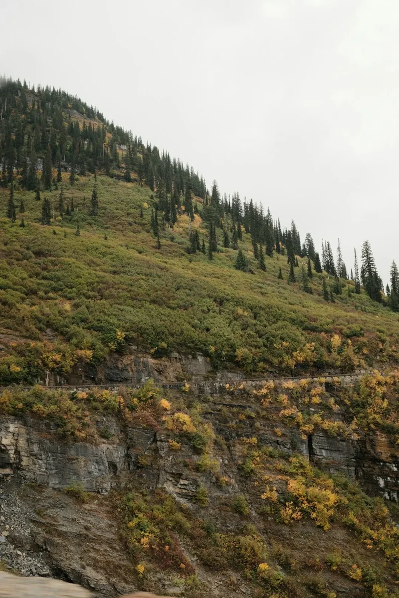
The Laurel Falls Trail is a quintessential Smoky Mountains experience, offering a delightful journey through a vibrant forest ecosystem culminating in a spectacular waterfall. The trail itself is a testament to thoughtful design, featuring a paved surface for most of its length, which significantly enhances accessibility and reduces erosion. This paved pathway makes it suitable for a wide range of visitors, including those with strollers or mobility aids, though it's important to note that the path is not entirely smooth and has some inclines. The trail begins its ascent from the trailhead, gradually climbing through a mixed deciduous forest dominated by oak and hickory trees. As you walk, the sounds of the forest envelop you – the rustling of leaves, the chirping of birds, and the distant murmur of water. The air is often filled with the scent of pine and damp earth, particularly after a rain shower.
The elevation gain of 106 metres is spread over the 2.25 km to the falls, meaning the climb is steady rather than steep, allowing for a comfortable pace. Along the way, you'll encounter smaller cascades and streams that feed into the larger Laurel Creek, adding to the trail's charm. The forest canopy provides ample shade, making it a pleasant walk even on warmer days, though it's always wise to be prepared for changing mountain weather. The trail is well-maintained and clearly marked, minimising the risk of getting lost. The anticipation builds as you approach the falls, with the sound of rushing water becoming more pronounced. Upon reaching Laurel Falls, visitors are greeted by a breathtaking sight: a magnificent two-tiered waterfall that cascades approximately 12 metres over a rocky cliff face. The upper tier is a wider, more gentle flow, while the lower tier is a more concentrated plunge into a clear pool. The area around the falls is a popular spot for photos and a place to simply sit and enjoy the natural spectacle. The return journey follows the same paved path, offering a different perspective of the forest as you descend back to the trailhead.
The popularity of Laurel Falls means it can be quite busy, especially during peak seasons and weekends. Arriving early in the morning or later in the afternoon can help avoid the largest crowds. Despite its popularity, the trail retains its natural beauty and offers a genuine connection with the Appalachian wilderness. The combination of an accessible path, a beautiful forest environment, and a stunning waterfall makes Laurel Falls Trail a must-do for many visitors to the Great Smoky Mountains National Park.
History and Cultural Context
The area surrounding Laurel Falls has a rich history intertwined with the indigenous peoples who first inhabited these mountains and the subsequent development of the Great Smoky Mountains National Park. Long before European settlers arrived, the Cherokee people, who called themselves the Tsalagi, lived in and utilized the resources of these mountains for centuries. Their ancestral lands encompassed the very valleys and ridges through which the Laurel Falls Trail now winds. The Cherokee were skilled hunters, farmers, and artisans, deeply connected to the natural world. They understood the medicinal properties of plants, the habits of wildlife, and the rhythms of the seasons. While specific historical records detailing Cherokee use of the immediate Laurel Falls area are scarce, it is highly probable that they traversed these routes for hunting, gathering, and as part of their extensive network of trails connecting various settlements and resource areas.
Following the forced removal of the Cherokee from their ancestral lands in the 1830s, European-American settlers began to move into the region. These settlers, often of Scots-Irish descent, established farms and small communities in the valleys and foothills. Logging became a significant industry in the late 19th and early 20th centuries, with vast tracts of forest being cleared for timber. The area around Laurel Falls would have experienced logging activities, though the rugged terrain and the eventual establishment of the national park helped preserve significant portions of the old-growth forest.
The creation of the Great Smoky Mountains National Park in the 1930s was a monumental effort involving land acquisition from private owners and the displacement of many remaining residents. The park was established to preserve the unique natural beauty and biodiversity of the Appalachian Mountains. The development of trails and facilities within the park, including the Laurel Falls Trail, was part of this preservation and access initiative. The trail itself was constructed in the mid-20th century, with its paved surface being a notable feature designed to accommodate a high volume of visitors and provide easier access to the waterfall. The decision to pave the trail was a pragmatic one, aimed at managing erosion and making the falls accessible to a broader range of people, including families with young children and individuals with mobility challenges. The trail's construction and ongoing maintenance reflect the park's mission to balance preservation with public enjoyment, ensuring that iconic natural features like Laurel Falls can be appreciated by generations to come while minimising human impact on the surrounding environment.
Seasonal Highlights and Weather Reality
The Laurel Falls Trail offers a distinct experience throughout the year, with each season bringing its own unique charm and challenges. Understanding these seasonal variations is key to planning a successful visit.
Spring (March to May): This is arguably one of the best times to visit Laurel Falls. As the winter snows recede, the forest floor awakens with a vibrant display of wildflowers. Trilliums, rhododendrons, and various other spring ephemerals carpet the undergrowth, adding splashes of colour to the emerging green landscape. The waterfalls are often at their most powerful during spring due to increased rainfall and snowmelt, creating a dramatic spectacle. The weather can be variable, with cool mornings and warmer afternoons, and occasional rain showers are common. Temperatures typically range from 5°C to 15°C.
Summer (June to August): Summer brings lush, dense greenery to the forest. The trees are in full leaf, providing ample shade along the paved trail, making it a popular choice for escaping the heat. However, this is also the busiest season, and the trail can be crowded, especially during midday. The waterfalls are still impressive, though they may be less powerful than in spring if rainfall is lower. Humidity can be high, and afternoon thunderstorms are frequent. Temperatures typically range from 20°C to 30°C, with higher elevations offering cooler relief.
Autumn (September to November): Autumn is another spectacular season for the Laurel Falls Trail. The hardwood forests transform into a breathtaking tapestry of reds, oranges, and yellows as the leaves change colour. This is a prime time for leaf-peeping, and the views from the trail, though partially obscured by trees, are enhanced by the vibrant foliage. The weather is generally cooler and drier than in summer, with crisp air and clear skies often prevailing. The waterfalls remain a significant draw, and the reduced crowds compared to summer make for a more peaceful experience. Temperatures typically range from 10°C to 20°C.
Winter (December to February): While less popular, winter offers a unique and serene experience at Laurel Falls. The forest is bare, allowing for more expansive views of the surrounding mountains and the waterfall itself. If temperatures drop below freezing, the waterfall can transform into an ice sculpture, creating a magical, albeit less dynamic, display. The trail is often less crowded, offering a sense of solitude. However, visitors must be prepared for cold temperatures, potential ice on the paved path (making traction devices like microspikes advisable), and shorter daylight hours. Temperatures typically range from -5°C to 5°C. Snowfall can occur, sometimes temporarily closing the trail or making access difficult.
Weather Reality: Regardless of the season, mountain weather can change rapidly. Always check the forecast before your visit and be prepared for rain, wind, and temperature fluctuations. Layers of clothing are essential, and waterproof outer gear is highly recommended year-round.
Recommended Itinerary

Laurel Falls Trail - Day Hike Itinerary
Early Morning (Approx. 8:00 AM - 9:00 AM):
- Depart from Gatlinburg or your accommodation.
- Drive towards the Great Smoky Mountains National Park via US-441 S.
- Continue on US-441 S to Little River Road.
- Turn right onto Little River Road and proceed for approximately 3.5 km.
- Turn right onto Laurel Falls Trailhead Road.
- Arrive at the Laurel Falls Trailhead. Parking is limited and fills quickly, so an early start is recommended.
Morning (Approx. 9:00 AM - 11:00 AM):
- Begin the hike on the Laurel Falls Trail.
- Distance: 2.25 km to the falls.
- Elevation Gain: Gradual ascent of approximately 106 m.
- Trail Surface: Paved for most of the route, with some uneven sections and steps.
- Key Waypoints:
- Trailhead marker and information board.
- Various points offering glimpses of the surrounding forest and smaller cascades.
- The trail gradually climbs, offering increasing views as you ascend.
- Enjoy the sights and sounds of the forest, keeping an eye out for local flora and fauna.
- Take your time to appreciate the transition from the lower forest to the area surrounding the falls.
Midday (Approx. 11:00 AM - 12:30 PM):
- Arrive at Laurel Falls.
- Spend time admiring the two-tiered waterfall, which cascades approximately 12 metres.
- Take photographs and enjoy the natural beauty of the area.
- Note: The area around the falls can be slippery and crowded. Exercise caution.
- Consider a short break for snacks or a light lunch.
Afternoon (Approx. 12:30 PM - 2:00 PM):
- Begin the return hike from Laurel Falls back to the trailhead.
- Distance: 2.25 km descent.
- Trail Surface: Paved, but be mindful of the downhill gradient.
- Key Waypoints:
- Retrace your steps along the paved path.
- Observe the forest from a different perspective on the descent.
- Arrive back at the Laurel Falls Trailhead.
- Depart from the trailhead and begin your journey back to Gatlinburg or your next destination.
Important Notes:
- This is a day hike; no overnight accommodation is required.
- Parking is extremely limited and can be challenging, especially during peak hours and seasons. Arrive early or consider visiting on a weekday.
- The trail is paved but can be uneven in places. Sturdy walking shoes are recommended.
- Be prepared for changing weather conditions. Carry water, snacks, and rain gear.
- Stay on the marked trail and do not venture off-path.
- Do not feed the wildlife.
Planning and Bookings
Book Your Trip
Everything you need to plan your journey
Accommodation
Find places to stay near Gatlinburg, Tennessee
Flights
Search flights to Gatlinburg, Tennessee
Essential Preparation
The Laurel Falls Trail is a popular day hike within the Great Smoky Mountains National Park, meaning preparation focuses on logistics and ensuring a comfortable and safe experience rather than complex booking coordination. The closest major gateway city is Knoxville, Tennessee, which has a well-serviced airport (TYS). From Knoxville, it's approximately a one-hour drive to Gatlinburg, Tennessee, the primary base town for accessing the park's popular eastern side. Gatlinburg offers a wide range of accommodation options, from budget-friendly motels and cabins to more upscale hotels and resorts. It also serves as a hub for dining, shopping, and outdoor gear stores. Visitors should plan their travel to Gatlinburg and then factor in the drive to the trailhead. It is highly recommended to arrive at the Laurel Falls Trailhead as early in the morning as possible, ideally before 9:00 AM, especially during peak seasons (spring break, summer, and autumn foliage season), as parking is extremely limited and often fills up by mid-morning. There are no permits required for hiking the Laurel Falls Trail itself, as it is within the national park boundaries, but standard park entrance fees may apply depending on the park's current regulations (check the official NPS website for the most up-to-date information on entrance fees and parking tags).
Trail Accommodation
This is a day hike requiring no overnight accommodation.
Required Gear
- Footwear: Sturdy, closed-toe walking shoes or hiking boots with good traction are essential. The paved trail can be uneven in places, and good grip will prevent slips, especially on the descent or if the path is wet.
- Clothing: Wear comfortable, moisture-wicking clothing suitable for the season. Layers are recommended, as mountain weather can change quickly. A waterproof and windproof jacket is advisable year-round.
- Navigation: While the trail is well-marked and paved, a basic map of the park or a reliable GPS device/app on your phone can be useful for orientation and understanding your location within the park. Ensure your phone is fully charged.
- Safety Gear: A basic first-aid kit for minor cuts and blisters is recommended. Carry a fully charged mobile phone, though signal can be intermittent within the park. A whistle can be useful in emergencies.
What to Bring
- Water: Carry at least 1-2 litres of water per person. There are no water sources available for refilling on the trail, and staying hydrated is crucial, especially during warmer months.
- Food: Pack snacks such as energy bars, fruit, or trail mix to keep your energy levels up during the hike. A light picnic lunch can be enjoyed at the falls if you plan to spend more time there.
- Sun Protection: Sunscreen (SPF 30 or higher), sunglasses, and a hat are recommended, even on cloudy days, as UV rays can be strong at higher elevations.
- Insect Repellent: Mosquitoes and other biting insects can be present, particularly during warmer months. Carry insect repellent to ward them off.
- Camera: To capture the beauty of the forest and the stunning waterfall.
- Trash Bag: Pack out everything you pack in, including all food wrappers and waste.
- Rain Gear: A lightweight, packable rain jacket and possibly rain pants are advisable, as showers can occur unexpectedly.
Permits
No specific permits are required to hike the Laurel Falls Trail. As a popular day hike within the Great Smoky Mountains National Park, access to the trail itself is free. However, visitors should be aware of the park's general regulations and potential fees. As of recent park policies, a parking tag is required for any vehicle parked for more than 15 minutes within the park boundaries. These parking tags can be purchased online or at various locations within the park. It is essential to check the official Great Smoky Mountains National Park website (nps.gov/grsm) for the most current information regarding entrance fees, parking tag requirements, and any other regulations that may be in effect during your visit. These fees contribute to the maintenance and preservation of the park's resources and facilities, including trails like Laurel Falls.
Other Activities in the Area
The Great Smoky Mountains National Park and its surrounding areas offer a wealth of activities for visitors to enjoy, complementing a hike to Laurel Falls:
- Cades Cove Loop Road: A scenic 11-mile (17.7 km) loop road offering opportunities to see historic buildings, wildlife (deer, black bears, turkeys), and stunning mountain vistas. It's best experienced early in the morning or late in the afternoon.
- Clingmans Dome: The highest point in the Great Smoky Mountains National Park, offering panoramic views from an observation tower. The drive to Clingmans Dome is scenic, and a short, steep paved path leads to the summit.
- Gatlinburg and Pigeon Forge Attractions: These nearby towns offer a wide array of family-friendly entertainment, including theme parks (Dollywood), dinner shows, aquariums, museums, and numerous shops and restaurants.
- Roaring Fork Motor Nature Trail: A one-way, 5.5-mile (8.9 km) scenic drive near Gatlinburg that showcases old-growth forest, historic buildings, and mountain streams. Several short hiking trails branch off from this road.
- Hiking Trails: The park boasts over 241.4 km (240 km) of hiking trails, ranging from easy strolls to challenging backcountry treks. Other popular options include Abrams Falls, Chimney Tops, and Alum Cave Bluffs.
- Scenic Drives: Beyond Laurel Falls Trail and Roaring Fork, consider driving the Newfound Gap Road (US-441) for spectacular mountain scenery, or explore the quieter roads on the North Carolina side of the park.
- Arts and Crafts Community: Gatlinburg is home to a renowned Arts and Crafts Community, where local artisans display and sell their handmade goods, including pottery, quilts, wood carvings, and paintings.
Safety and Conditions
Trail Conditions: The Laurel Falls Trail is paved for most of its length, which generally keeps it in good condition. However, the pavement can be uneven in places, and occasional debris may be present. After rain, the trail can become slippery, especially on the downhill sections. Always wear appropriate footwear with good traction.
Weather: Mountain weather is notoriously unpredictable. Be prepared for sudden changes in temperature, wind, and precipitation, regardless of the season. Check the weather forecast before your hike and pack layers of clothing. Afternoon thunderstorms are common during the summer months and can bring lightning, heavy rain, and flash flooding. Seek shelter immediately if you hear thunder.
Wildlife: The Great Smoky Mountains National Park is home to a diverse array of wildlife, including black bears, white-tailed deer, wild turkeys, and various smaller mammals and birds. While sightings can be exciting, it's crucial to maintain a safe distance and never feed the animals. Bears are most active at dawn and dusk. If you encounter a bear, do not approach it. Make noise to alert it to your presence and slowly back away. Carry bear spray if you plan to hike in more remote areas, though it is less commonly needed on the busy Laurel Falls Trail.
Crowds: Laurel Falls is one of the most popular trails in the park. Expect significant crowds, especially on weekends, holidays, and during peak seasons (spring and fall foliage). Parking at the trailhead is extremely limited and often fills up by mid-morning. Arriving very early (before 9:00 AM) or visiting on a weekday can help avoid the worst of the crowds. If the parking lot is full, do not park illegally or block traffic; consider visiting another trail or returning at a different time.
Water Safety: While the waterfall is beautiful, the water can be swift and cold. Exercise caution near the water's edge, especially with children. Do not attempt to swim in the pool at the base of the falls, as conditions can be hazardous.
Emergency Preparedness: Carry a fully charged mobile phone, though service can be spotty within the park. Know the park's emergency number (often 911 or a specific park ranger number). Inform someone of your hiking plans, including your intended route and expected return time.
Side Trips and Points of Interest
Laurel Falls: The primary destination of this trail, Laurel Falls is a stunning two-tiered waterfall that cascades approximately 12 metres (12 m) over a rocky cliff. The upper tier is a wider, more gentle flow, while the lower tier is a more concentrated plunge into a clear pool. The falls are particularly impressive after periods of rain, when the water volume increases significantly. The area around the falls is a popular spot for photography and a place to rest and enjoy the natural beauty. Be mindful of slippery rocks and exercise caution when approaching the water's edge.
Forest Ecosystem: The trail itself is a point of interest, showcasing the diverse plant life of the Great Smoky Mountains. As you walk, observe the various species of trees, such as oak, hickory, and maple, along with understory plants like rhododendron and mountain laurel (from which the falls derive their name). The paved path, while man-made, is designed to minimise impact on the surrounding forest. Keep an eye out for smaller cascades and streams that feed into Laurel Creek, adding to the trail's auditory and visual appeal.
Views of the Surrounding Mountains: Although the trail is largely canopied by trees, there are occasional openings that offer glimpses of the surrounding mountain ridges. These views provide a sense of the scale of the Great Smoky Mountains and the vastness of the national park. The perspective changes as you ascend, offering different vantage points of the forested slopes.
Historic Logging Era Remnants (Minor): While not a primary feature, the history of logging in the region means that remnants of past human activity can sometimes be found in the broader landscape. However, the Laurel Falls Trail itself is well-maintained and focused on natural features, so overt historical structures are not typically encountered directly on the path.
Leave No Trace
The Laurel Falls Trail, like all areas within the Great Smoky Mountains National Park, is a precious natural resource that requires careful stewardship. Adhering to Leave No Trace principles is paramount to preserving its beauty and ecological integrity for future generations. As a highly trafficked trail, the impact of each visitor is amplified, making responsible behaviour essential.
Plan Ahead and Prepare: Familiarise yourself with park regulations, check weather forecasts, and pack appropriately. Understand that parking is limited and can be a challenge; have alternative plans if the trailhead is full.
Travel and Camp on Durable Surfaces: Stick to the paved trail. Do not venture off-path into the forest, as this can damage fragile vegetation, disturb wildlife habitats, and contribute to erosion. The paved surface is designed to withstand heavy foot traffic and protect the underlying soil.
Dispose of Waste Properly: Pack it in, pack it out. This means carrying out all trash, including food scraps, wrappers, and any other litter. There are no trash receptacles on the trail or at the trailhead. Use the designated facilities at visitor centres or in nearby towns for disposal.
Leave What You Find: Do not take any natural objects, such as rocks, plants, or flowers, from the park. These items are part of the ecosystem and should be left for others to enjoy and for the health of the environment.
Minimise Campfire Impacts: Not applicable to this day hike, as campfires are prohibited on the Laurel Falls Trail and in most areas of the park outside designated campgrounds.
Respect Wildlife: Observe wildlife from a distance. Never feed animals, as this can alter their natural behaviour, make them dependent on human food, and potentially lead to dangerous encounters. Keep pets leashed and under control, or leave them at your accommodation if they are not permitted on the trail.
Be Considerate of Other Visitors: Keep noise levels down, yield to uphill hikers, and be mindful of others enjoying the natural surroundings. The paved trail can be narrow in places, so be courteous when passing.