Laugavegur Trail - Iceland's Highland Gem
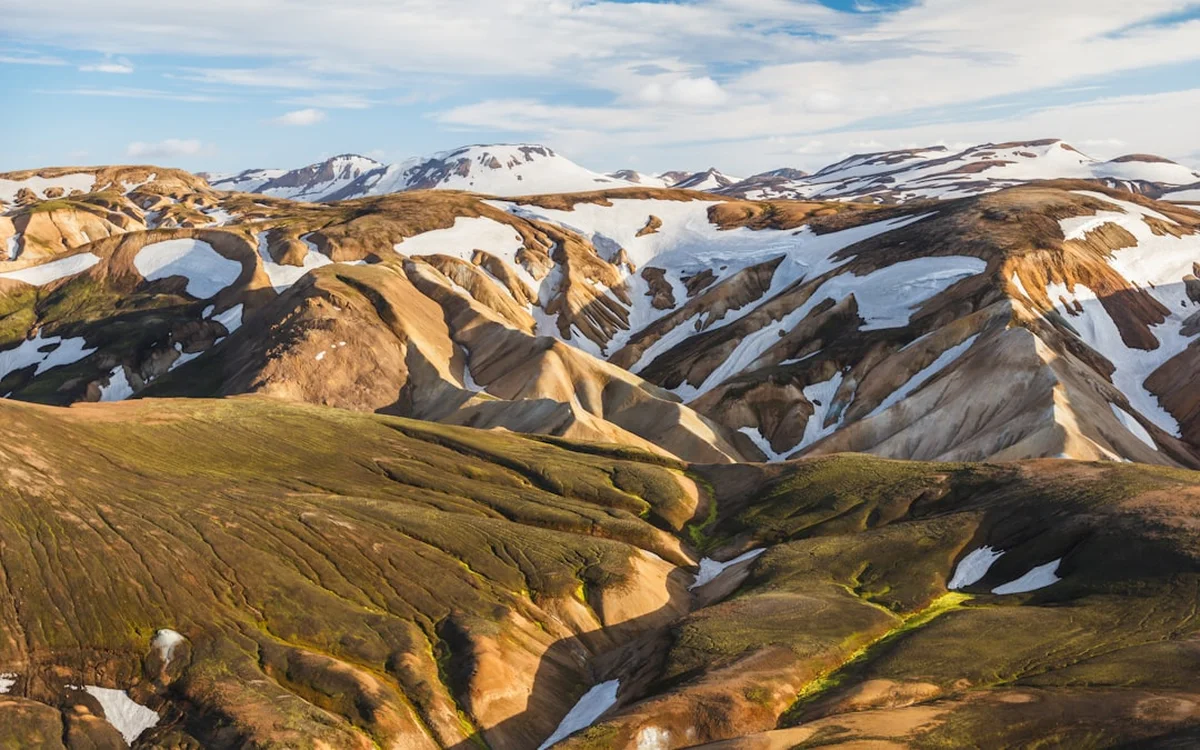
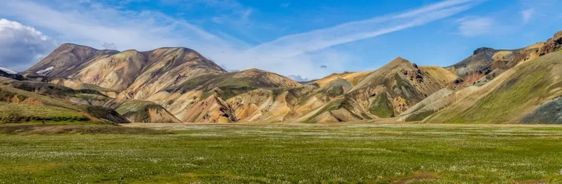
The Laugavegur Trail is Iceland's most celebrated multi-day trek, a spectacular 55-kilometre journey through the country's dramatic southern highlands. This iconic route winds through a landscape of unparalleled geological diversity, showcasing Iceland's raw, untamed beauty. From the vibrant, rhyolite mountains of Landmannalaugar, painted in hues of red, yellow, and green, to the stark, black obsidian deserts, the steaming geothermal areas of Hveradalir, and the lush, green valleys of Þórsmörk, the Laugavegur offers a visual feast at every turn. This challenging yet immensely rewarding trek is a true immersion into Iceland's volcanic heart, a land shaped by fire and ice.
- Distance: 55.0 km one-way
- Duration: 4-5 days
- Season: Late June to late September (weather dependent)
- Huts: Landmannalaugar, Hrafntinnusker, Álftavatn, Emstrur, Þórsmörk (reservations essential)
- Highest point: Hrafntinnusker (approx. 1,100 m)
- Difficulty: Challenging
- Direction: Typically walked from north to south (Landmannalaugar to Þórsmörk)
Overview
The Laugavegur Trail is a world-renowned hiking experience that traverses a landscape so alien and beautiful it feels like stepping onto another planet. The trek begins in the geothermal wonderland of Landmannalaugar, famous for its naturally heated hot springs and mountains of colourful rhyolite. As you ascend into the highlands, the scenery transforms dramatically. The first day's climb towards Hrafntinnusker introduces you to vast, desolate lava fields and steaming fumaroles, a stark reminder of the volcanic forces at play beneath your feet. The air here is often crisp and cold, with snow patches lingering even in summer.
The subsequent days offer a continuous spectacle of Iceland's geological artistry. You'll traverse the black obsidian sands of the Mælifellssandur desert, cross glacial rivers (often requiring careful wading or the use of bridges), and descend into verdant valleys carved by ancient ice flows. The trail passes through areas of intense geothermal activity, where the earth hisses and steams, and the air carries the distinct scent of sulphur. The contrast between the barren, volcanic landscapes and the pockets of vibrant green moss and hardy vegetation is striking.
The final leg of the journey leads into the Þórsmörk valley, a sheltered oasis nestled between three glaciers: Eyjafjallajökull, Mýrdalsjökull, and Tindfjallajökull. This area is a hiker's paradise, with lush birch forests, numerous hiking trails, and breathtaking views of the surrounding ice caps. The Laugavegur is not just a walk; it's an expedition through a living geological textbook, a testament to the power and beauty of nature in its most elemental form. The trail demands respect for its unpredictable weather and rugged terrain, but the rewards—unforgettable vistas and a profound connection with the wild—are immense.
History and Cultural Context
The Laugavegur Trail, while a relatively modern hiking route in its organised form, traverses land that has been known and used by Icelanders for centuries. The highlands, though harsh, have historically been a source of pasture for sheep during the summer months, and routes through these areas were vital for connecting different settlements and for seasonal herding practices. The name "Laugavegur" itself translates to "Warm River Road," referring to the geothermal activity encountered along the route, particularly in the Landmannalaugar area.
The formalisation of the Laugavegur as a hiking trail began in the mid-20th century, driven by a growing interest in outdoor recreation and a desire to showcase Iceland's unique natural heritage. The Icelandic Touring Association (FÍ) played a pivotal role in establishing and maintaining the huts and marking the trail, making it accessible to a wider range of hikers. Early pioneers and guides explored these remote areas, charting paths and identifying the most scenic and geologically significant points of interest.
The trail's popularity surged in the late 20th and early 21st centuries as Iceland became a more prominent international tourist destination. Its designation as part of a protected natural area, and its inclusion in various "world's best hikes" lists, cemented its status as a must-do trek. The trail's route has been refined over time to balance accessibility with the preservation of its fragile environment, often rerouting sections to avoid sensitive vegetation or to better navigate challenging terrain. Today, the Laugavegur is a testament to Iceland's commitment to preserving its natural landscapes while sharing their wonder with the world.
Seasonal Highlights and Weather Reality
The Laugavegur Trail is accessible for hiking only during a short summer window, typically from late June to late September. Outside this period, the highlands are virtually impassable due to heavy snow, ice, and extreme weather conditions, making the trail dangerous and requiring advanced mountaineering skills.
Late June to July: This is the beginning of the hiking season. The landscape is often at its most vibrant, with wildflowers blooming and the rivers at their lowest (though still requiring careful crossing). Snow may still linger on higher passes, particularly around Hrafntinnusker, but the days are long, offering ample daylight for hiking. The weather can be highly variable, with sunshine, rain, and wind all possible within a single day.
August: Considered by many to be the prime month for hiking the Laugavegur. The weather is generally more stable, though still unpredictable. The long daylight hours continue, and the landscape is a riot of colour. The huts are fully operational, and the trail is well-trodden. This is also the busiest period, so booking accommodation well in advance is crucial.
September: The autumn colours begin to appear, adding a new dimension to the already stunning scenery. The days are shorter, and the weather can become more challenging, with a higher chance of rain, wind, and even early snow. However, September can offer a more tranquil experience with fewer crowds. The geothermal areas remain active, and the stark beauty of the highlands is ever-present.
Weather Reality: It cannot be overstated that the weather in the Icelandic highlands is extreme and can change with astonishing speed. Hikers must be prepared for all conditions, including strong winds (which can reach hurricane force), heavy rain, sleet, snow, and fog, even in mid-summer. Temperatures can drop close to freezing, especially at higher elevations. Hypothermia is a genuine risk, and appropriate clothing and gear are essential.
Recommended Itinerary
4-Day Laugavegur Trail Itinerary (North to South)
Day 1: Landmannalaugar to Hrafntinnusker
- Distance: 12 km
- Elevation gain: Approx. 600 m
- Time: 4–5 hours
- Start at the Landmannalaugar hut, a vibrant geothermal area
- Ascend through colourful rhyolite mountains
- Pass through the steaming geothermal area of Hveradalir
- Cross obsidian fields and potentially snow patches
- Arrive at Hrafntinnusker hut, situated in a stark, high-altitude environment
- This day is characterised by dramatic colour changes and geothermal activity
Day 2: Hrafntinnusker to Álftavatn
- Distance: 12 km
- Elevation loss: Approx. 400 m
- Time: 3–4 hours
- Descend from the high plateau
- Traverse black sand and gravel plains
- Cross glacial rivers (may require wading or using bridges)
- Pass the small lake Álftavatn
- Arrive at Álftavatn hut, located by the lake with views of the surrounding mountains
- A day of stark contrasts, moving from high desert to a more serene lakeside setting
Day 3: Álftavatn to Emstrur
- Distance: 15 km
- Elevation gain/loss: Mixed, approx. 200 m net loss
- Time: 5–6 hours
- Continue through varied terrain, including black sand deserts
- Cross the powerful Markarfljót river (bridge available)
- Enter the Emstrur valley, known for its dramatic canyons and green vegetation
- Arrive at Emstrur hut, nestled in a sheltered valley
- This day offers a mix of challenging river crossings and beautiful canyon scenery
Day 4: Emstrur to Þórsmörk (Básar or Hvolsvöllur)
- Distance: 15 km to Þórsmörk (Básar)
- Elevation loss: Approx. 300 m
- Time: 5–6 hours
- Descend into the Þórsmörk valley
- Cross the Krossá river (requires a bus or careful wading, depending on conditions)
- Arrive at Þórsmörk (Básar), a beautiful birch forest valley
- From Þórsmörk, you can take a bus to Hvolsvöllur or continue on other trails
- The final day offers a transition into a lush, sheltered environment
Optional 5th Day: Exploring Þórsmörk
- Spend an extra day exploring the numerous hiking trails within Þórsmörk, offering stunning views of glaciers and surrounding mountains.
Important Notes:
- Hut reservations are mandatory and must be booked months in advance.
- Huts are basic and do not provide food or cooking equipment.
- Weather can change rapidly; always be prepared for cold, wind, and rain.
- River crossings can be dangerous; check conditions and use bridges where available.
- Mobile phone signal is intermittent at best.
- Carry sufficient food and water treatment supplies.
Planning and Bookings
Book Your Trip
Everything you need to plan your journey
Accommodation
Find places to stay near Reykjavik
Flights
Search flights to Reykjavik
Essential Preparation
Planning for the Laugavegur Trail requires meticulous attention to detail, especially concerning accommodation and transport. The trail is remote, and services are limited. The closest major town with comprehensive facilities is Hvolsvöllur, which serves as a primary transport hub for buses to and from the trailheads. Reykjavik is the capital city and the main international gateway, offering all necessary amenities for pre-trip preparations, including gear rental and purchasing supplies.
Logistics: The most common way to access the trail is via bus from Reykjavik or Hvolsvöllur to Landmannalaugar (the northern trailhead) and then taking a bus from Þórsmörk (the southern trailhead) back to Hvolsvöllur or Reykjavik. These bus services operate only during the summer season and must be booked in advance. Driving to Landmannalaugar is possible with a 4x4 vehicle, but the F-roads (mountain roads) are rough and often require crossing unbridged rivers, making bus transport a safer and more convenient option for most hikers.
Fitness: The Laugavegur Trail is considered challenging due to its distance, varied terrain, and the unpredictable weather. Hikers should be in good physical condition, capable of walking for 4-6 hours per day with a backpack weighing 10-15 kg. Prior experience with multi-day hiking and navigating in potentially adverse conditions is highly recommended.
Trail Accommodation
Accommodation along the Laugavegur Trail consists of mountain huts operated by the Icelandic Touring Association (FÍ) and the Directorate of Agriculture (for Þórsmörk). These huts are basic but provide essential shelter. Camping is permitted only in designated areas near the huts.
Huts:
- Landmannalaugar: Large hut with dormitories, cooking facilities, and a campsite. Natural hot springs are nearby.
- Hrafntinnusker: Smallest and most basic hut, often with limited space. Camping is available but exposed.
- Álftavatn: Hut with dormitories, cooking facilities, and a campsite by a lake.
- Emstrur: Hut with dormitories, cooking facilities, and a campsite in a sheltered valley.
- Þórsmörk (Básar): A larger complex with multiple huts, dormitories, cooking facilities, and extensive camping areas within a beautiful birch forest.
Booking Requirements: Hut reservations are absolutely essential and must be made months in advance, especially for July and August. They can be booked through the FÍ website (www.fi.is). Camping is generally allowed near the huts, but a small fee may apply, and hikers are expected to use designated camping spots and hut facilities.
Facilities Provided: Huts typically offer bunk beds (bring your own sleeping bag), a common area for eating and socialising, and basic cooking facilities (gas stoves, but no pots, pans, or utensils). Toilets are usually available near the huts. Water is sourced from nearby streams and should be treated.
What's NOT Provided: Food, cooking equipment (pots, pans, cutlery, plates), sleeping bags, pillows, electricity, charging facilities, or heating. Huts are unheated, relying on body heat and insulation.
Seasonal Availability: Huts are generally open from late June to late September, coinciding with the hiking season. Outside these dates, they are closed and unstaffed.
Costs: Hut fees vary but typically range from ISK 8,000 to 12,000 per person per night for dormitories. Camping fees are usually around ISK 2,000 to 3,000 per person per night.
Required Gear
- Waterproof and windproof outer layers: A high-quality jacket and trousers are non-negotiable. Gore-Tex or similar breathable, waterproof fabric is essential.
- Insulating layers: Fleece or down jacket, thermal base layers (merino wool or synthetic).
- Sturdy hiking boots: Waterproof, broken-in boots with good ankle support are crucial for navigating varied terrain and river crossings.
- Warm hat and gloves: Essential for cold temperatures and wind.
- Sleeping bag: A 3-season bag rated to at least 0°C comfort is recommended.
- Backpack: 50-70 litre capacity, with a rain cover.
- Navigation tools: Map, compass, and a GPS device or smartphone with offline maps. Trail marking can be sparse in places.
- Headlamp: With spare batteries, for early starts or late finishes.
- First-aid kit: Comprehensive kit including blister treatment, pain relievers, and any personal medications.
- Sun protection: Sunglasses, high SPF sunscreen, and a hat, as the sun can be intense even on cloudy days.
What to Bring
- Food: Lightweight, high-energy food for 4-5 days (breakfasts, lunches, dinners, snacks). No food is available for purchase on the trail.
- Water treatment: Water filter or purification tablets, as stream water should be treated.
- Cooking equipment: Lightweight stove, fuel, pot, mug, bowl, spoon, knife.
- Toiletries: Biodegradable soap, toothbrush, toothpaste, toilet paper, hand sanitiser.
- Trekking poles: Highly recommended for stability on descents and river crossings.
- Dry bags: To keep essential gear dry inside your backpack.
- Personal items: Camera, power bank for electronics, book, journal.
- Cash: For bus fares and potential small purchases at huts (though card payment is often accepted).
Permits
While there are no specific "permits" required to walk the Laugavegur Trail itself in the sense of a daily quota for independent hikers (unlike some other famous trails), booking accommodation in the huts is mandatory and functions as a de facto permit system. These huts are operated by the Icelandic Touring Association (FÍ) and the Directorate of Agriculture, and they have limited capacity. Booking well in advance is the most critical step for anyone planning to hike the Laugavegur.
Hut Booking Process:
- When to Book: Bookings typically open in early autumn for the following summer season (e.g., October for the next summer). Due to high demand, especially for July and August, it is advisable to book as soon as reservations become available.
- Where to Book: Reservations are made online through the FÍ website (www.fi.is). The system allows you to select your desired dates and huts.
- Flexibility: Be prepared to be flexible with your dates and hut choices. Popular dates and huts can sell out very quickly. Having alternative dates or a slightly adjusted itinerary in mind can be beneficial.
- Confirmation: Once booked, you will receive a confirmation email. It is advisable to print this or have a digital copy readily accessible.
Camping: Camping is permitted in designated areas near the huts. While generally less restrictive than hut bookings, it is still recommended to check local regulations and potentially pay a small camping fee, especially in popular areas like Þórsmörk. Camping outside designated areas is generally discouraged to protect the fragile environment.
Bus Transport: Bus tickets for transport to and from the trailheads also need to be booked in advance, particularly during peak season. Companies like Straeto (public transport) and private operators (e.g., Reykjavik Excursions, Trex) offer services. Ensure your bus bookings align with your hut reservations.
No Daily Quota: Unlike some other international trails, the Laugavegur does not enforce a strict daily quota for independent hikers. However, the limited hut capacity means that the trail can become very crowded, especially during peak season. The number of people camping also contributes to the overall impact on the environment.
Other Activities in the Area
The Laugavegur Trail is situated in a region of Iceland renowned for its dramatic natural beauty and unique geological features. Extending your trip to explore the surrounding areas offers a deeper appreciation of this extraordinary landscape:
- Landmannalaugar Hot Springs: Before or after your trek, soak in the natural geothermal pools in Landmannalaugar. These mineral-rich waters are a perfect way to relax and rejuvenate.
- Day Hikes from Landmannalaugar: The area around Landmannalaugar offers numerous shorter hiking trails, including the popular Bláhnúkur (Blue Peak) hike for panoramic views and the Laugahraun lava field walk.
- Fimmvörðuháls Trail: For experienced hikers, the Fimmvörðuháls trail (often combined with Laugavegur for a 5-7 day trek) offers a challenging route between Þórsmörk and Skógar, passing through the site of the 2010 Eyjafjallajökull eruption.
- Exploring Þórsmörk: Spend an extra day or two in the Þórsmörk valley. Hike to viewpoints like Valahnúkur, explore the birch forests, or simply enjoy the serene atmosphere.
- Glacier Tours: From the Mýrdalsjökull glacier (near Þórsmörk), guided glacier hiking or ice climbing tours can be arranged for an adventurous experience on the ice.
- South Coast Attractions: If travelling to or from the trailheads, consider visiting the famous waterfalls of Seljalandsfoss and Skógafoss, the black sand beaches of Reynisfjara, and the charming village of Vík.
- Volcano Tours: Learn about Iceland's volcanic activity with guided tours or visits to relevant visitor centres, particularly concerning the Eyjafjallajökull and Katla volcanoes.
Safety and Conditions
Weather: The most significant safety concern on the Laugavegur Trail is the unpredictable and extreme weather. Hikers must be prepared for rapid changes, including strong winds, heavy rain, fog, and snow, even in mid-summer. Hypothermia is a serious risk. Always check the weather forecast from reliable sources like the Icelandic Met Office (Veðurstofa Íslands) before and during your hike.
River Crossings: Several river crossings are part of the Laugavegur Trail. These rivers are fed by glacial meltwater and can rise rapidly, especially after rain or during warmer periods. Always assess the river's depth and current before attempting to cross. Use bridges where available. If a river appears too dangerous to cross, do not attempt it. Wait for conditions to improve or seek alternative routes or assistance. Trekking poles can provide valuable stability.
Navigation: While the trail is generally well-marked, visibility can be severely reduced by fog, making navigation difficult. Carry a map, compass, and GPS device or smartphone with offline maps. Familiarise yourself with the route before you start.
Terrain: The trail traverses varied and challenging terrain, including loose scree, sharp obsidian fields, muddy paths, and rocky sections. Proper footwear and careful footing are essential to prevent injuries.
Communication: Mobile phone reception is unreliable and often non-existent in the highlands. Consider carrying a personal locator beacon (PLB) or satellite phone for emergencies. Inform someone of your hiking plans and expected return time.
Hut Etiquette and Safety: Follow hut rules and guidelines. Keep noise to a minimum, especially during sleeping hours. Ensure stoves are turned off when not in use. Report any issues or concerns to the hut warden.
Emergency Services: In case of an emergency, contact the Icelandic Search and Rescue (ICE-SAR) via the emergency number 112. Be prepared to provide your exact location and the nature of the emergency.
Travel Insurance: It is highly recommended to have travel insurance that covers hiking and potential emergency evacuation from remote areas.
Side Trips and Points of Interest
Hveradalir Geothermal Area: Located on the first day of the trek, Hveradalir is a spectacular display of Iceland's geothermal power. Steaming vents, bubbling mud pots, and colourful mineral deposits create an otherworldly landscape. The vibrant hues of the rhyolite mountains here are a photographer's dream.
Landmannalaugar Hot Springs: A must-visit before or after your hike. These natural hot springs offer a perfect opportunity to relax and soak in the stunning surroundings. The contrast between the warm water and the cool highland air is invigorating.
Mælifellssandur Black Desert: This vast expanse of black volcanic sand is a stark and impressive feature of the Laugavegur Trail. The sheer scale and emptiness of the desert create a profound sense of isolation and awe.
Markarfljót River Canyon: On the third day, the trail passes near the impressive canyon carved by the Markarfljót river. The views from the canyon rim are breathtaking, showcasing the erosive power of glacial meltwater.
Þórsmörk Valley: The destination of the Laugavegur, Þórsmörk is a lush, sheltered valley renowned for its birch forests and dramatic mountain scenery. It serves as a gateway to further hiking adventures, including the Fimmvörðuháls trail.
Eyjafjallajökull and Mýrdalsjökull Glaciers: The trail offers views of these imposing ice caps, which have shaped the surrounding landscape and played significant roles in Iceland's geological history. The proximity to Eyjafjallajökull, the volcano that famously erupted in 2010, adds a layer of geological fascination.
Leave No Trace
The Laugavegur Trail traverses a fragile and unique ecosystem. Adhering to Leave No Trace principles is paramount to preserving its beauty and integrity for future generations. The highlands are particularly sensitive to human impact.
Plan Ahead and Prepare: Research the trail, weather, and regulations. Book accommodation and transport in advance. Pack appropriate gear to minimise the need for emergency rescues.
Travel and Camp on Durable Surfaces: Stick to marked trails to avoid damaging vegetation. Camp only in designated areas near huts. Avoid trampling fragile mosses and lichens.
Dispose of Waste Properly: Pack out everything you pack in, including all food scraps, wrappers, and toilet paper. Use designated toilets at huts. If no toilet is available, dig a cathole at least 60 metres away from water sources, trails, and campsites.
Leave What You Find: Do not remove rocks, plants, or any natural or cultural artifacts. Take only photographs and memories.
Minimise Campfire Impacts: Campfires are generally prohibited in the Icelandic highlands due to the risk of wildfires and the slow regeneration of vegetation. Use a lightweight stove for cooking.
Respect Wildlife: Observe wildlife from a distance. Do not feed any animals, as this can disrupt their natural behaviour and diet.
Be Considerate of Other Visitors: Keep noise levels down, especially in huts and campsites. Respect the solitude and experience of others.
By following these principles, you help ensure that the Laugavegur Trail remains a pristine and awe-inspiring wilderness experience.
Useful Links
- Icelandic Touring Association (FÍ) - Laugavegur Trail
- Icelandic Met Office - Landmannalaugar Weather Forecast
- Icelandic Met Office - Þórsmörk Weather Forecast
- Straeto - Public Transport Iceland (Bus routes)
- Reykjavik Excursions - Laugavegur Bus Services
- SafeTravel Iceland - Travel Information and Safety Advice
- Environment Agency of Iceland - National Parks