New Zealand — Wairoa
Walk the remote Lake Waikaremoana Track, a 46km moderate route through Te Urewera's mist-shrouded wilderness on New Zealand's North Island. This ancient forest trail hugs the pristine lake's shoreline, offering secluded bays and diverse vegetation. Traverse varied terrain, from forest paths to rugged slopes, experiencing the profound spiritual significance of this protected land. A 3-4 day immersion in natural beauty.
Distance: 46.0 km
Elevation Gain: 780 m
Difficulty: Moderate
Duration: 3-4 days
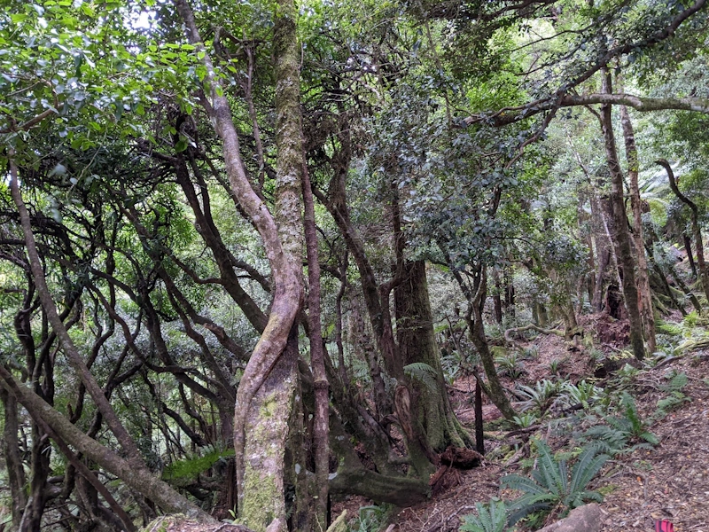
The Lake Waikaremoana Track is a 46-kilometre journey through the remote, mist-shrouded wilderness of Te Urewera on New Zealand's North Island. Unlike many of the country's other Great Walks, which are managed primarily by the Department of Conservation, this track traverses land that is legally a person—Te Urewera was granted legal personhood in 2014, reflecting its profound spiritual and cultural significance to the Tūhoe people, the "Children of the Mist." The route follows the shoreline of the North Island's deepest lake, formed 2,200 years ago by a massive landslide that blocked the Waikaretaheke River. This is a landscape of ancient podocarp forests, dramatic sandstone bluffs, and hidden waterfalls, where the silence is broken only by the call of the kākā or the rustle of the North Island robin. It is a walk that demands a slower pace, inviting hikers to connect with the "mauri" (life force) of the forest and the enduring heritage of the Tūhoe people.
The Lake Waikaremoana Track offers a distinct experience compared to the alpine vistas of the South Island Great Walks. Here, the beauty lies in the intimacy of the rainforest and the ever-present vista of the lake's deep, sapphire waters. The track is a masterclass in ecological diversity, transitioning from the high-altitude beech forests of the Panekire Range to the lush, fern-heavy podocarp forests of the lake edge. The lake itself, sitting at 600 metres above sea level, is the focal point of the journey, its intricate shoreline providing a constant companion as the trail winds through secluded bays and over forested headlands.
The physical challenge of the track is front-loaded. For those starting at Onepoto, the first day involves a sustained climb of approximately 600 metres to the summit of the Panekire Range. This section provides the most dramatic views of the entire walk, with the Panekire Bluffs offering a sheer drop-off and a panoramic perspective of the lake's vast expanse and the surrounding sea of green hills. Once the descent from the range is completed on Day 2, the track settles into a more rhythmic, undulating pattern. While the elevation changes are less extreme, the terrain remains rugged, with tree roots, muddy patches after rain, and numerous small stream crossings that require steady footing.
What sets Waikaremoana apart is its atmosphere. Te Urewera is one of the largest remaining tracts of native forest in the North Island, and the sense of isolation is palpable. There are no roads, no permanent settlements, and very little light pollution. At night, the forest comes alive with the sounds of the ruru (morepork) and the occasional kiwi. The track is not just a physical challenge; it is a cultural immersion. Walkers are guests in the home of the Tūhoe people, and the management of the track reflects a partnership between the Crown and the iwi (tribe), focusing on the preservation of both the natural environment and the cultural stories embedded in the land.
The history of Lake Waikaremoana is inextricably linked to the Ngāi Tūhoe iwi. For centuries, the Tūhoe have lived in the rugged valleys of Te Urewera, earning the name "Nga Tamariki o te Kohu" (the Children of the Mist) due to the frequent low-lying clouds that blanket the region. The lake itself was formed by a catastrophic landslide approximately 2,200 years ago, which blocked a narrow gorge and created a natural dam. In Māori tradition, the lake's creation is attributed to the struggles of Haumapuhia, a legendary figure who, in her attempts to find a way to the sea, formed the many arms and bays of the lake before being turned to stone at the lake's outlet.
During the 19th century, Te Urewera became a final stronghold for Māori resistance against European colonisation. The rugged terrain provided a natural fortress for Te Kooti, a prominent Māori leader and prophet, during the New Zealand Wars. The Crown's "scorched earth" policy during this period led to significant hardship for the Tūhoe people, a history that remains a vital part of the local consciousness. For much of the 20th century, the area was managed as a National Park, but in a landmark 2014 settlement, the New Zealand government passed the Te Urewera Act. This legislation removed the National Park status and declared Te Urewera a legal entity with "all the rights, powers, duties, and liabilities of a legal person." It is now managed by the Te Urewera Board, comprising representatives from both Tūhoe and the Crown, with a focus on the concept of "Te Kawa o Te Urewera"—the internal living system of the land.
The track itself was developed to allow visitors to experience this unique environment while respecting its sacred nature. Many of the place names along the route—such as Panekire, Waiopaoa, and Marauiti—carry deep ancestral meanings. Walking the track today is an act of acknowledging this complex history, from the ancient geological formation of the lake to the modern-day restoration of Tūhoe stewardship.
Want more background? Read extended notes on history and cultural context → Learn more
Lake Waikaremoana is located in a temperate rainforest zone, meaning rain is a possibility at any time of year. The weather is influenced by the high elevation of the lake and the surrounding ranges, which can trap moisture coming off the Pacific Ocean.
Summer (December to February): This is the most popular time to walk. Temperatures are mild, ranging from 15°C to 25°C, and the lake is warm enough for swimming in the sheltered bays. However, this is also the busiest season, and huts must be booked well in advance. The forest is at its most vibrant, and the long daylight hours allow for a relaxed pace.
Autumn (March to May): Many locals consider this the best time for the track. The air is crisper, the light is softer for photography, and the summer crowds have thinned. The weather is often more stable than in spring, though the nights begin to get cold, especially at the higher-altitude Panekire Hut.
Winter (June to August): The track remains open, but conditions can be challenging. Snow is common on the Panekire Range, and the track can become very muddy and slippery. Temperatures often drop below freezing at night. This season is only recommended for experienced hikers with high-quality cold-weather gear. The huts are much quieter, offering a profound sense of solitude.
Spring (September to November): This is a season of transition. Rainfall is typically higher, and the waterfalls, including the spectacular Korokoro Falls, are at their most powerful. The forest is alive with new growth and birdsong. Hikers should be prepared for rapidly changing conditions and "four seasons in one day."
Day 1: Onepoto to Panekire Hut
Day 2: Panekire Hut to Waiopaoa Hut
Day 3: Waiopaoa Hut to Marauiti Hut
Day 4: Marauiti Hut to Hopuruahine Landing
Important Notes:
The Lake Waikaremoana Track is located in a remote part of the North Island. The nearest town with full services is Wairoa, which is approximately 1.5 to 2 hours away via State Highway 38. This road is partially unsealed and very winding; drivers should exercise caution and allow plenty of time. There is no mobile phone coverage on most of the track or the access roads.
Fitness is a key consideration. While the track is classified as a Great Walk, the climb to Panekire is significant, and the track surface is often uneven with roots and mud. Hikers should have experience carrying a multi-day pack (10–15 kg) over varied terrain. Booking coordination is vital: you must book your huts/campsites through the Department of Conservation (DOC) website and separately arrange your water taxi transport with local operators based in Tuai or Wairoa.
There are five Department of Conservation huts and several designated campsites along the track. During the Great Walks season, these must be booked in advance.
Hut Facilities:
Campsites:
What is NOT provided:
To walk the Lake Waikaremoana Track, you must book your accommodation in advance. There is no "permit" required to walk the trail itself, but staying overnight in the huts or campsites requires a valid booking confirmation. The track is part of the Great Walks network, and bookings typically open in May or June for the following season (July to June).
Booking Process:
Costs (Subject to change):
Water Taxi Logistics:
Because the track is a one-way route, most hikers use a water taxi to get to the start or return from the finish. These are private operators and are not included in your DOC booking. It is common to park your car at the Onepoto end (or a secure location in Tuai) and take a water taxi to Hopuruahine to walk back, or vice versa. Ensure you book your taxi at the same time as your huts to avoid being stranded.

Detailed route notes, maps, logistics & tips for the Lake Waikaremoana Track (PDF).

Precisely traced GPX for the Lake Waikaremoana Track, ready for your GPS or favourite mapping app.
Te Urewera and the Wairoa district offer several other ways to experience the region's natural beauty and culture:
Weather Awareness: The most significant risk on the Lake Waikaremoana Track is the weather. The Panekire Range is exposed to high winds and driving rain. Hypothermia is a genuine risk, even in summer, if you are not properly equipped. Always check the MetService "Te Urewera" backcountry forecast before starting. If a severe weather warning is in place, consider delaying your start.
Track Conditions: The track is rugged. Expect mud, slippery tree roots, and uneven surfaces. The descent from Panekire is particularly hard on the knees. Take your time, use trekking poles if you have them, and be mindful of your footing, especially in wet conditions.
Water Safety: While the lake looks inviting, it is deep and cold. Only swim in designated areas or sheltered bays. When crossing streams, be aware that they can rise rapidly during heavy rain. If a stream looks unsafe to cross, wait for the water level to drop.
Communication: There is no mobile phone signal on the track. You are in a remote wilderness. Carrying a Personal Locator Beacon (PLB) is the only reliable way to signal for help in an emergency. PLBs can be rented from outdoor stores in major cities or sometimes from the visitor centre in Tuai.
Biosecurity: To protect the forest from Kauri Dieback and other diseases, ensure all your gear—especially boots and tent pegs—is spotlessly clean before arriving at the track. Use the cleaning stations if provided.
Korokoro Falls: This is the essential side trip of the Waikaremoana Track. Located about midway between Waiopaoa and Marauiti huts, a signposted track leads off the main trail. The 1-hour return walk follows the Korokoro Stream to a stunning 22-metre waterfall that plunges over a sheer basalt lip into a deep pool. The falls are surrounded by lush ferns and mosses, creating a truly magical atmosphere.
Panekire Bluffs: While the main track passes along the top of these bluffs, it is worth taking the time to stop at the various lookout points. The bluffs are formed from ancient sandstone and siltstone, and the sheer drop provides a dramatic sense of the scale of the landscape. On a clear day, you can see across the entire lake to the distant mountains of the Huiarau Range.
The "Sunken Forest": In some of the shallower bays, particularly near the Onepoto end, you can see the remains of trees standing underwater. These are remnants of the forest that was submerged when the lake was formed by the landslide 2,200 years ago. The cold, low-oxygen water has preserved the wood for millennia.
Lou's Lookout: A short climb near the Onepoto trailhead that offers an alternative perspective of the lake and the geological features of the landslide debris. It is a great spot for those who may not be doing the full hike but want a taste of the views.
As a guest in Te Urewera, it is your responsibility to uphold the principles of "Te Kawa o Te Urewera" and Leave No Trace. This ensures the environment remains pristine for the Tūhoe people and future visitors.