Lake O'Hara Alpine Circuit - The Crown Jewel of the Canadian Rockies
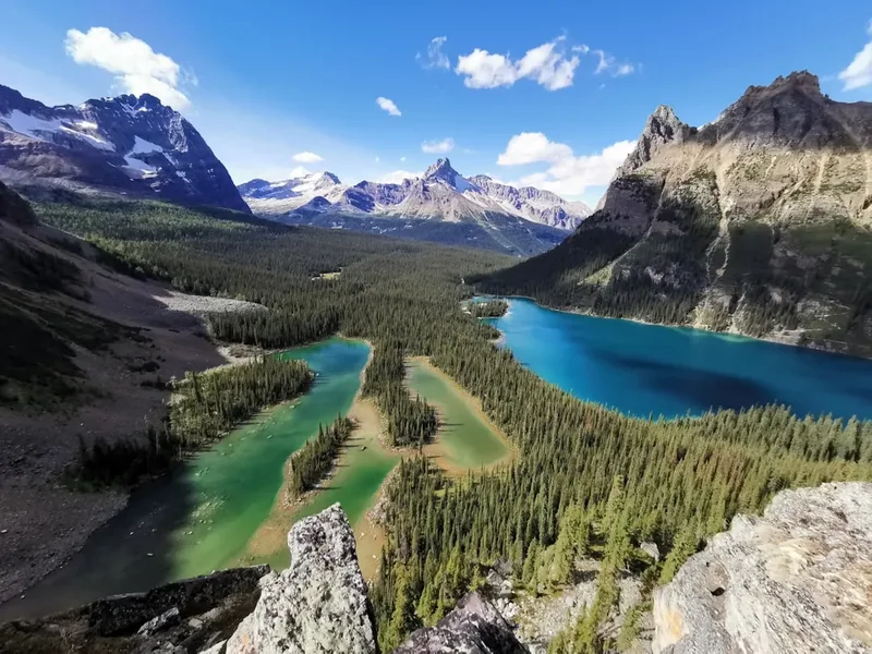
The Lake O'Hara Alpine Circuit is widely considered the most spectacular day hike in North America, a high-altitude odyssey that traverses the hanging valleys, sheer ledges, and turquoise tarns of Yoho National Park in British Columbia, Canada. This 11-kilometre masterpiece is not a single path but a meticulously linked series of alpine routes that circumnavigate the Lake O'Hara basin, offering a level of scenery that is usually reserved for elite mountaineers. Because Parks Canada strictly limits access to the area via a tightly controlled bus service, the circuit provides a rare sense of solitude and pristine wilderness that is increasingly difficult to find in the busy corridors of the Rocky Mountains. From the dizzying heights of Wiwaxy Gap to the larch-filled meadows of the Opabin Plateau, every metre of this trail is a testament to the raw, glaciated beauty of the Continental Divide.
- Distance: 11.0 km (Circuit only; excludes 11 km access road)
- Elevation Gain: 800 m to 1,000 m (depending on side trips)
- Duration: 6–8 hours
- Difficulty: Challenging (requires steady footing and a head for heights)
- Highest Point: Wiwaxy Gap (2,530 m)
- Access: Pre-booked Parks Canada shuttle bus or 11 km walk-in
- Season: Early July to late September (snow-dependent)
- Trail Markers: Blue paint squares on rocks (Alpine Route markers)
Overview
The Lake O'Hara Alpine Circuit is a sophisticated network of trails designed to keep hikers above the treeline for as long as possible. Unlike traditional valley-bottom hikes, the circuit utilises "alpine routes"—sections of trail that involve scrambling over talus slopes, navigating narrow rock ledges, and ascending steep couloirs. The route was largely pioneered and refined by Lawrence Grassi, a legendary trail builder whose stonework remains visible today in the form of perfectly placed rock steps and stable paths through chaotic boulder fields. The circuit is designed to be walked in a counter-clockwise direction, which tackles the steepest ascent—the climb to Wiwaxy Gap—while legs are fresh and the morning light is hitting the surrounding peaks of Mount Lefroy and Mount Victoria.
The landscape is defined by its geology. The towering peaks are composed of Cathedral Formation limestone and quartzite, carved by successive ice ages into the dramatic "hanging valleys" that characterise the area. As you traverse the Huber Ledges and Yukness Ledges, you are walking on the literal bones of the mountains, with Lake O'Hara shimmering like a sapphire hundreds of metres below. The water colour in this basin is world-renowned; the "rock flour" or glacial silt suspended in the water refracts light to create shades of turquoise, teal, and deep navy that seem almost artificial in their intensity.
Solitude is the defining characteristic of the O'Hara experience. By limiting the number of visitors to approximately 250 people per day (including campers and lodge guests), Parks Canada has preserved the ecological integrity of the alpine meadows. This is a place where the whistle of a hoary marmot or the distant thunder of a calving glacier are the primary sounds. For the prepared hiker, the Alpine Circuit is more than just a walk; it is a continuous sequence of "best-of" moments, where every corner turned reveals a new perspective on the most photographed mountains in Canada. It demands physical fitness and mental focus, particularly on the exposed ledges, but the reward is a profound connection to the high alpine environment.
History and Cultural Context
The history of Lake O'Hara is a blend of Indigenous heritage, early mountaineering exploration, and a unique philosophy of conservation. Long before European surveyors arrived, the Ktunaxa and Stoney Nakoda peoples travelled through these high passes, though the rugged terrain of the upper O'Hara basin was likely visited primarily for seasonal hunting or spiritual purposes. The area's modern name is attributed to Colonel Robert O'Hara, an Irishman who reportedly visited the lake in the late 19th century after hearing of its beauty from government surveyors.
The true "golden age" of Lake O'Hara began with the arrival of the Canadian Pacific Railway (CPR) and the subsequent development of mountain tourism. In the early 1900s, the CPR recognised the area's potential and established a permanent camp. Unlike the grand hotels at Lake Louise or Banff, O'Hara was kept intentionally rustic to appeal to "serious" outdoorspeople and artists. The famous Group of Seven painter J.E.H. MacDonald spent many summers here, capturing the dramatic light and form of the peaks in works that are now central to Canadian art history. His presence helped cement O'Hara's reputation as a place of quiet contemplation and aesthetic power.
The physical trails themselves are the legacy of Lawrence Grassi, an Italian immigrant and coal miner who became one of the most respected mountain guides and trail builders in the Rockies. Grassi’s work in the 1950s and 60s transformed the circuit from a series of rough scrambles into a world-class hiking route. He had an uncanny ability to "read" the rock, placing massive slabs of quartzite so precisely that they have remained stable for over half a century without the use of mortar. When you climb the steps toward Lake Oesa or navigate the Huber Ledges, you are walking on his handiwork. Today, the Lake O'Hara Trails Club, a non-profit organisation, continues this legacy, working closely with Parks Canada to maintain the trails to the highest standards while ensuring the fragile alpine flora is protected from the feet of thousands of annual visitors.
Want more background? Read extended notes on history and cultural context → Learn more
Seasonal Highlights and Weather Reality
The hiking season at Lake O'Hara is exceptionally short, typically running from late June or early July until the end of September. Because of its high elevation (the lake itself sits at 2,020 m), snow can linger on the high passes well into mid-summer. In a heavy snow year, the Wiwaxy Gap and All Soul's Prospect sections of the circuit may remain impassable without mountaineering equipment until mid-July. Conversely, the first autumn snowfalls often arrive in early September, potentially coating the ledges in dangerous ice.
July and August: This is the peak of the alpine summer. The meadows are carpeted in wildflowers, including Western Anemone (towhead babies), Indian Paintbrush, and Heather. The days are long, with light lasting until 10:00 PM, providing ample time to complete the circuit. However, this is also the season for afternoon thunderstorms. In the high alpine, lightning is a significant risk; hikers should aim to be off the high ledges and passes by early afternoon if the forecast suggests convective activity.
September: Many consider this the best time to visit. The air is crisp, the mosquitoes have vanished, and the Subalpine Larches (Larix lyallii) begin their spectacular transformation. These unique deciduous conifers turn a brilliant golden-yellow before dropping their needles, usually peaking in the third week of September. The sight of golden larches against the turquoise water and dusting of fresh "watermelon snow" on the peaks is the quintessential O'Hara experience. However, temperatures can drop well below freezing at night, and hikers must be prepared for wintry conditions.
Winter and Spring: From October to June, the area is the domain of ski tourers and snowshoers. The access road is not plowed, adding 11 km of travel each way. Avalanche risk is extreme on almost all sections of the Alpine Circuit during these months. Only those with advanced winter backcountry skills and avalanche training should consider visiting during this period.
Recommended Itinerary
The Full Alpine Circuit Route Progression
Segment 1: Lake O'Hara Shoreline to Wiwaxy Gap
- Distance: 2.2 km
- Elevation Gain: 510 m
- Time: 1.5–2 hours
- Start at the warden cabin near the bus drop-off point.
- Follow the trail toward the northeast, beginning the relentless ascent of Wiwaxy East Face.
- The trail climbs through thick forest before emerging into subalpine scrub and finally open scree.
- Expect steep switchbacks and "Grassi steps" that gain elevation rapidly.
- Reach Wiwaxy Gap (2,530 m), the highest point on the circuit.
- Views from the gap look down into the Cataract Brook valley and across to the peaks of the Great Divide.
Segment 2: Huber Ledges to Lake Oesa
- Distance: 2.0 km
- Elevation: Minimal gain, mostly traversing and slight descent
- Time: 1–1.5 hours
- From Wiwaxy Gap, follow the blue markers onto the Huber Ledges.
- This is a high-level traverse across the base of Mount Huber.
- The trail is narrow and exposed in places but generally level.
- Navigate across stable talus slopes and rock benches.
- The turquoise expanse of Lake Oesa begins to appear below.
- Descend slightly to reach the shores of Lake Oesa, a perfect spot for a mid-morning break.
Segment 3: Yukness Ledges to Opabin Plateau
- Distance: 2.5 km
- Elevation: 100 m gain / 150 m loss
- Time: 1.5–2 hours
- From Lake Oesa, follow the trail south toward the Yukness Ledges.
- This section is famous for its "sidewalk-like" quartzite slabs.
- The trail hugs the side of Yukness Mountain, offering the best aerial views of Lake O'Hara and Mary Lake.
- Look for the "blue squares" to stay on the route through boulder fields.
- The trail eventually rounds a shoulder and enters the Opabin Plateau, a hanging valley filled with small tarns and larch groves.
Segment 4: Opabin Prospect and All Soul's Prospect
- Distance: 3.0 km
- Elevation: 250 m gain
- Time: 1.5–2 hours
- Take the short detour to "Opabin Prospect" for the iconic view of Lake O'Hara and Mary Lake framed by mountains.
- Continue across the plateau toward the base of Mount Schaffer.
- Begin the steep, final climb of the day up to All Soul's Prospect.
- The trail ascends through a rugged couloir and over loose scree.
- Reach the summit of the prospect (2,435 m) for a 360-degree view of the entire basin.
Segment 5: Descent via Schaffer Lake to Le Relais
- Distance: 2.3 km
- Elevation: 415 m descent
- Time: 1 hour
- Descend steeply from All Soul's Prospect toward Schaffer Lake.
- The trail passes through beautiful larch forest and alpine meadows.
- At Schaffer Lake, follow the signs for the Alpine Meadows trail or the Big Larches trail back to the Lake O'Hara shoreline.
- Finish at Le Relais day shelter to wait for the return bus.
Important Notes:
- The circuit can be shortened by skipping Wiwaxy Gap and heading straight to Lake Oesa via the lower trail.
- Always follow the blue paint markers; they indicate the safest route through technical terrain.
- If weather turns, descend to the valley floor at the nearest junction (Lake Oesa or Opabin Plateau).
- The 11 km access road must be walked if you do not have a bus reservation (allow 2.5–3 hours extra).
- Water is available in the lakes but must be treated or filtered.
Planning and Bookings
Book Your Trip
Everything you need to plan your journey
Accommodation
Find places to stay near Lake Louise
Flights
Search flights to Lake Louise
Essential Preparation
The primary challenge of the Lake O'Hara Alpine Circuit is not the physical hike, but the logistics of getting there. Parks Canada limits the number of people who can enter the area to protect the fragile environment. You cannot simply drive to the lake; the access road is restricted to the Parks Canada shuttle bus, lodge guests, and those staying at the Elizabeth Parker Hut. If you do not have a bus reservation, you must walk the 11 km (one-way) gravel access road, which adds 22 km of round-trip walking to your day—a feat that makes the Alpine Circuit a 33 km ultramarathon.
Preparation should begin months in advance. The bus reservation system is a random-draw lottery that typically takes place in March. You must also be physically prepared for high-altitude hiking. The air is thinner here, and the terrain is rugged. Ensure you have a base in Lake Louise or Field, as the drive from Banff or Canmore adds significant time to an already long day. Check the Yoho National Park trail report daily for updates on snow levels and bear activity.
Trail Accommodation
There are four ways to stay overnight at Lake O'Hara, each requiring a different booking strategy and offering a different level of comfort.
1. Lake O'Hara Campground:
- Managed by Parks Canada.
- 30 sites available; maximum 3 nights stay.
- Bookings are extremely competitive and usually sell out the moment they open in the spring.
- Facilities: Bear-proof food lockers, a cooking shelter, pit toilets, and treated water.
- Note: You are limited to one large bag per person on the bus.
2. Elizabeth Parker Hut:
- Operated by the Alpine Club of Canada (ACC).
- A rustic, historic log cabin with communal sleeping platforms.
- Requires a separate lottery system for summer bookings (usually held in the previous winter).
- Facilities: Propane stoves, kitchenware, and mattresses provided. You must bring your own sleeping bag and food.
3. Lake O'Hara Lodge:
- A high-end, private lodge offering luxury rooms and cabins.
- Includes all meals and private shuttle transport.
- Bookings often happen a year in advance, with many returning guests.
- This is the most expensive option but provides unparalleled comfort.
4. Day Trip (No Accommodation):
- Most visitors come for the day via the shuttle bus.
- If you fail to get a bus or accommodation, you can walk in and camp elsewhere in Yoho, but there is no "random camping" allowed in the O'Hara basin.
Required Gear
- Hiking Boots: Sturdy, waterproof boots with good ankle support are essential. The circuit involves significant time on sharp quartzite scree and narrow ledges.
- Bear Spray: This is grizzly bear country. Carry bear spray in an accessible holster (not inside your pack) and know how to use it.
- Layered Clothing: Temperatures can swing from 20°C in the sun to 5°C in a sudden alpine squall. Bring a moisture-wicking base layer, an insulating mid-layer (fleece or down), and a high-quality waterproof shell.
- Navigation: A physical map of the O'Hara trail system and a compass or GPS. While the trails are marked with blue squares, cloud cover can reduce visibility to a few metres.
- Sun Protection: The UV radiation is intense at 2,500 m. Bring a hat, sunglasses with UV protection, and high-SPF sunscreen.
What to Bring
- Food: Bring high-energy snacks and a substantial lunch. There is no food for sale at Lake O'Hara, except for small snacks (and legendary carrot cake) at the Le Relais day shelter, which has limited hours and is cash-preferred.
- Water Treatment: Carry at least 2 litres of water. You can refill from alpine streams, but the water must be filtered or treated to prevent Giardia.
- First Aid Kit: Include blister pads (moleskin), antiseptic wipes, bandages, and any personal medications.
- Trekking Poles: Highly recommended for the steep descent from All Soul's Prospect and to save your knees on the "Grassi steps."
- Headlamp: Even on a day hike, carry a headlamp with extra batteries in case you are delayed and have to walk the access road out in the dark.
Permits
Accessing Lake O'Hara requires specific permits and reservations, which are among the most sought-after in the Canadian National Park system. There is no "gate" where you can buy a permit on the day; everything must be organised in advance through the Parks Canada Reservation Service.
The Shuttle Bus Lottery:
- For day use, Parks Canada typically operates a random-draw lottery system.
- Applications usually open in March for the upcoming summer season.
- You pay a non-refundable application fee to enter the lottery for specific dates.
- If successful, you are assigned a bus time (usually 8:30 AM or 10:30 AM).
- The bus reservation includes your return trip.
Camping Permits:
- Camping reservations are separate from the day-use lottery.
- They usually open on a specific date in January or February on a first-come, first-served basis via the Parks Canada website.
- A camping reservation automatically includes your bus seat.
National Park Entry Pass:
- In addition to your O'Hara-specific reservation, you must have a valid Parks Canada Discovery Pass or a daily entry pass for Yoho National Park.
- These can be purchased at the park gates, visitor centres in Field or Lake Louise, or online.
Standby and Cancellations:
- There is no formal "standby" line at the bus parking lot. However, if there are empty seats on a bus due to no-shows, the driver may occasionally allow walk-on passengers (payment is usually cash only). This is extremely unreliable and not recommended as a primary plan.
- Check the reservation website frequently in the 48 hours leading up to your desired date, as cancellations do occasionally appear.
Other Activities in the Area
Yoho National Park and the nearby Banff National Park offer a wealth of world-class experiences to complement your O'Hara hike:
- Takakkaw Falls: One of the highest waterfalls in Canada, located at the end of the Yoho Valley Road. A short, paved walk leads to the base of the thundering 373-metre drop.
- The Iceline Trail: Another premier high-line hike in Yoho that offers spectacular views of the Vice President and Emerald Glaciers.
- Emerald Lake: Famous for its vivid green water, this lake offers canoe rentals and a gentle 5 km shoreline circuit, perfect for a recovery day.
- Burgess Shale Fossil Hikes: Join a guided Parks Canada hike to one of the world's most significant fossil sites, containing 500-million-year-old marine specimens.
- Lake Louise and Moraine Lake: Located just 20 minutes east, these iconic lakes are must-sees, though they require their own shuttle reservations.
- The Natural Bridge: A powerful display of the Kicking Horse River carving through solid rock, located near the village of Field.
Safety and Conditions
Alpine Weather: Weather in the Canadian Rockies is notoriously unpredictable. A blue-sky morning can transform into a snowstorm or a violent thunderstorm within an hour. If you see dark clouds building or hear thunder, immediately descend from high ridges like the Huber Ledges or All Soul's Prospect. Hypothermia is a risk even in summer if you get wet and the wind picks up.
Terrain Hazards: The Alpine Circuit involves "Class 2" scrambling. This means you will occasionally need to use your hands for balance. The rock is mostly solid quartzite, but scree slopes can be unstable. Watch for rockfall from the peaks above, especially if there are other hikers higher up the slope. The ledges are wide enough for safe passage, but they have significant "exposure"—a fall in certain sections could be fatal. If you suffer from severe vertigo, the Wiwaxy Gap and Huber Ledges may be overwhelming.
Wildlife: Yoho National Park is prime habitat for Grizzly and Black bears. The Lake O'Hara area is often subject to "Group Access" restrictions, where hikers are legally required to walk in groups of four or more to deter bear encounters. Always make noise (call out "Yo bear!") when moving through thick brush or near rushing water. If you encounter a bear, do not run. Back away slowly and prepare your bear spray.
Route Finding: While the trails are well-maintained, the Alpine Circuit sections are marked with blue paint squares on rocks rather than a continuous dirt path. In foggy or snowy conditions, these markers can be hard to find. If you lose the markers, stop and backtrack to the last one you saw. Do not attempt to "shortcut" down steep slopes, as many end in impassable cliffs (cliffing out).
Emergency Services: There is no mobile phone reception in the Lake O'Hara basin. In an emergency, you must reach the Warden Cabin near the lake or use a satellite communication device (like a Garmin inReach). Rescue by helicopter is the only way out for serious injuries, and it is dependent on weather and daylight.
Side Trips and Points of Interest
Lake McArthur: If you have extra energy or a second day, Lake McArthur is a mandatory detour. It is the deepest lake in the area and possesses a startling, deep cobalt blue colour that contrasts sharply with the turquoise of O'Hara. The trail to McArthur is less technical than the Alpine Circuit but equally beautiful, passing through the "Big Larches" forest.
Odaray Highline: This trail offers perhaps the best view in the entire park, looking straight down the McArthur Valley. However, it is often subject to a voluntary "scent-based" closure or a limit of four groups per day to protect a vital wildlife corridor for grizzly bears. Check at Le Relais for the current status.
The Seven Veils Falls: A delicate series of waterfalls located on the far side of Lake O'Hara. A gentle shoreline trail leads to the base of the falls, providing a relaxing alternative to the high-altitude ledges.
Opabin Prospect: Even if you don't do the full circuit, the walk to the Opabin Prospect is essential. It provides the "postcard view" of Lake O'Hara and Mary Lake sitting side-by-side, separated by a narrow forested ridge. It is particularly stunning during the larch season in late September.
Le Relais Day Shelter: A historic log building that serves as the social hub for day hikers. It’s the place to get information from the Lake O'Hara Trails Club volunteers, buy a map, or enjoy a slice of their famous carrot cake while waiting for the bus. Note: They do not take credit cards; bring cash.
Leave No Trace
The Lake O'Hara basin is one of the most ecologically sensitive areas in the Canadian Rockies. The combination of high elevation, short growing seasons, and thin soils means that a single footprint off-trail can destroy plants that have taken decades to grow. The "O'Hara Ethic" is one of extreme care and respect for the landscape.
Key Principles for Lake O'Hara:
- Stay on the Trail: This is the most important rule. Do not step off the trail to take a photo or pass another hiker. In the meadows, stay on the rock steps or the hardened path.
- Pack It In, Pack It Out: There are no rubbish bins on the trails. Take everything back to the trailhead, including fruit peels and tissues.
- Respect Wildlife: Do not feed the marmots, pikas, or ground squirrels. Feeding them habituates them to humans and can lead to their death. Observe bears and mountain goats from a distance of at least 100 metres.
- No Drones: The use of drones is strictly prohibited in all Canadian National Parks to protect wildlife and the visitor experience.
- Human Waste: Use the pit toilets at the trailhead, the campground, or Lake Oesa. If you are caught short on the high ledges, follow LNT guidelines: dig a cat-hole 20 cm deep at least 70 m from water, and pack out your toilet paper.
- Leave What You Find: Do not pick wildflowers or remove rocks or fossils. The beauty of O'Hara belongs to everyone; leave it exactly as you found it.