Lake Angelus Route
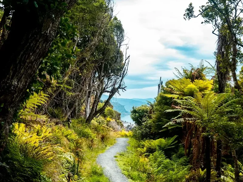
The Lake Angelus Route is a spectacular day walk located in the heart of Nelson Lakes National Park, New Zealand. This challenging yet rewarding trail ascends through diverse beech forest and alpine tussock lands to the stunning alpine tarn of Lake Angelus, nestled beneath the rugged peaks of the St Arnaud Range. Offering breathtaking panoramic views of the surrounding mountains and lakes, this route is a must-do for those seeking an immersive alpine experience without the commitment of an overnight trek. The journey is a testament to the raw beauty of New Zealand's Southern Alps, showcasing dramatic landscapes that change with every metre of elevation gained.
- Distance: 13.0 km one-way
- Duration: 6–8 hours return
- Season: November to April (best conditions); snow possible outside this window
- Highest point: Approximately 1,600 m near Lake Angelus
- Elevation gain: 760 m
- Difficulty: Moderate to challenging (due to elevation gain and alpine conditions)
- Trailhead: Mt Robert Carpark, Lake Rotoiti
- Access: Via SH6 and Mt Robert Road from Nelson (approx. 2 hours drive)
- Permits: No permits required for day hiking
Overview
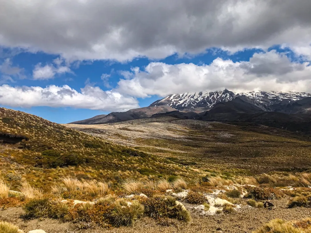
The Lake Angelus Route is a classic alpine day walk that provides an exceptional introduction to the dramatic landscapes of Nelson Lakes National Park. The trail begins with a steady climb through mature beech forest, where the air is cool and damp, and the forest floor is carpeted with moss and ferns. As the elevation increases, the forest gradually thins, giving way to open tussock slopes and rocky outcrops. The final ascent to Lake Angelus is a steep, exposed climb that rewards hikers with unparalleled views of the glacial-carved valley and the jewel-like lake itself.
Lake Angelus, situated at an elevation of approximately 1,600 metres, is a truly mesmerising sight. Its deep blue waters are often surrounded by snow-capped peaks, even in summer, and the area offers a sense of remote wilderness. The route is well-maintained but can be steep and exposed in sections, particularly the final push to the lake. Hikers should be prepared for rapidly changing weather conditions typical of alpine environments. The descent offers a different perspective on the landscape, allowing for reflection on the journey and the stunning scenery encountered.
This walk is suitable for reasonably fit individuals with some hiking experience. The elevation gain and the potential for challenging weather mean it should not be underestimated. The combination of forest, alpine meadows, and the dramatic lake basin makes the Lake Angelus Route a memorable and visually stunning experience.
History and Cultural Context
The Nelson Lakes region, including the area around Lake Angelus, has a rich history intertwined with both Māori and European settlement. For Māori, particularly the iwi of Ngāti Apa, this area was a significant mahinga kai (food gathering area) and a route for travel between different territories. The lakes and mountains held spiritual importance, and knowledge of the land's resources and safe passage was passed down through generations.
European exploration and settlement in the 19th century brought surveyors and prospectors to the region. The development of tracks and huts by the New Zealand Forest Service and later the Department of Conservation has made these alpine areas more accessible to recreational users. The Mt Robert area, from which the Lake Angelus Route departs, was named after Robert McDowall, a surveyor who explored the region in the late 19th century. The establishment of Nelson Lakes National Park in 1956 was a crucial step in preserving the unique ecological and scenic values of this alpine environment.
The Lake Angelus Route itself has evolved from early tramping tracks, with improvements made over time to enhance safety and accessibility. The construction of the Mt Robert Carpark and the development of the network of trails leading to Lake Angelus reflect a long-standing appreciation for the area's natural beauty and its potential for outdoor recreation. The route continues to be a popular destination, offering a challenging yet accessible alpine adventure.
Seasonal Highlights and Weather Reality
The Lake Angelus Route is best enjoyed during the warmer months, typically from November to April. During this period, the snow generally recedes from the higher sections of the track, making it safer and more accessible for day hikers.
Spring (November–December): The landscape begins to awaken after winter. Alpine wildflowers may start to appear, and the beech forests are vibrant green. However, snow can linger in sheltered gullies and on higher slopes, and early spring weather can be unpredictable, with potential for late snowfalls or strong winds. Waterfalls and streams will be at their fullest due to snowmelt.
Summer (January–February): This is generally the most stable period for weather, with longer daylight hours. The alpine meadows are at their most colourful with a variety of alpine flora. However, summer can also bring intense sun, and sandflies can be present, especially in the lower forest sections. The higher elevations can still experience cold snaps and sudden storms.
Autumn (March–April): The beech forests turn to stunning shades of gold and red, offering spectacular autumnal colours. The air is crisp and clear, and sandfly activity usually decreases. However, daylight hours shorten, and the risk of early snowfalls on the higher passes increases as winter approaches. The weather can become more unsettled.
Winter (May–October): The Lake Angelus Route is generally considered a winter alpine route during these months. Significant snow and ice cover the track, making it impassable and dangerous for unequipped and inexperienced hikers. Avalanche risk is a serious concern. Only experienced mountaineers with appropriate winter gear (ice axe, crampons, avalanche safety equipment) and knowledge should consider attempting this route during winter. The Mt Robert Carpark may also be inaccessible due to snow.
Weather: Alpine weather is notoriously fickle. Be prepared for sun, rain, wind, and even snow on the same day, regardless of the season. Always check the forecast before you go and be ready to turn back if conditions deteriorate.
Recommended Itinerary
Lake Angelus Route - Day Walk Itinerary
Early Morning (Approx. 8:00 AM): Start at Mt Robert Carpark
- Begin at the Mt Robert Carpark, located at the end of Mt Robert Road.
- The initial section of the track is well-formed and relatively gentle, ascending through native beech forest.
- Enjoy the cool, shaded environment and the sounds of the forest.
Morning (Approx. 9:00 AM - 11:00 AM): Forest Ascent and Ridge Views
- The track begins to climb more steadily, with occasional viewpoints offering glimpses of Lake Rotoiti and the surrounding valleys.
- You will pass through sections of dense beech forest, with moss-covered trees and a rich undergrowth of ferns.
- The gradient increases as you approach the treeline.
Midday (Approx. 11:00 AM - 1:00 PM): Alpine Meadows and First Lake Views
- Emerge from the forest into open alpine tussock and herb fields.
- The terrain becomes more exposed, with wider panoramic views opening up.
- You may catch your first distant views of Lake Angelus, nestled in its alpine basin.
- The track continues to ascend, often following ridgelines.
Afternoon (Approx. 1:00 PM - 3:00 PM): Arrival at Lake Angelus and Exploration
- The final section involves a steeper, more challenging climb, potentially over rocky terrain.
- Arrive at the stunning Lake Angelus. Take time to admire the views, have lunch, and explore the immediate surroundings.
- Note the dramatic peaks surrounding the lake and the clear, cold alpine water.
- Be aware of rapidly changing weather conditions at this altitude.
Late Afternoon (Approx. 3:00 PM - 6:00 PM): Descent and Return to Carpark
- Begin the descent back to the Mt Robert Carpark.
- The descent can be hard on the knees, so take your time and use trekking poles if you have them.
- Enjoy the changing light and perspectives on the landscape as you retrace your steps.
- Arrive back at the Mt Robert Carpark, completing your 6–8 hour round trip.
Important Notes:
- This is a day walk; no overnight accommodation is available on the route itself.
- The track is well-marked but can be steep and exposed.
- Always check the weather forecast before departing and be prepared for rapid changes.
- Carry sufficient water and food for the entire duration of the walk.
- Wear sturdy, broken-in hiking boots.
- Trekking poles are highly recommended for the steep ascents and descents.
Planning and Bookings
Book Your Trip
Everything you need to plan your journey
Accommodation
Find places to stay near Nelson
Flights
Search flights to Nelson
Essential Preparation
The Lake Angelus Route is a day walk, so the planning focuses on ensuring you are adequately prepared for an alpine environment. The closest major city is Nelson, which is approximately a 2-hour drive from the Mt Robert Carpark. Nelson offers a full range of services, including outdoor gear shops, supermarkets, and accommodation. It is advisable to base yourself in Nelson or the nearby town of St Arnaud before and after your hike.
Fitness: This walk requires a moderate to good level of fitness due to the significant elevation gain (760 m) and the duration of 6–8 hours. You should be comfortable walking for extended periods on uneven terrain and be able to manage steep ascents and descents.
Logistics: Access to the trailhead is via Mt Robert Road, which branches off State Highway 6. The road is sealed for a portion and then becomes gravel. It is generally suitable for 2WD vehicles, but it's advisable to check current road conditions with the Department of Conservation (DOC) or local authorities, especially outside of summer, as it can be affected by weather. Ample parking is available at the Mt Robert Carpark.
Trail Accommodation
This is a day hike requiring no overnight accommodation.
Required Gear
- Sturdy hiking boots: Waterproof and well broken-in, with good ankle support.
- Waterproof and windproof jacket: Essential for protection against sudden alpine weather changes.
- Waterproof overtrousers: To keep dry during rain showers.
- Warm layers: Including a fleece or down jacket, and thermal base layers (merino wool is ideal). Avoid cotton.
- Hat and gloves: Even in summer, temperatures at higher elevations can be cold.
- Sun protection: High SPF sunscreen, sunglasses, and a wide-brimmed hat. The sun can be intense at altitude.
- Navigation: A map of the area and a compass are recommended. A GPS device or smartphone with offline maps can also be useful, but do not rely solely on electronics.
- Head torch: With spare batteries, in case of unexpected delays or if you start earlier/finish later than planned.
- First-aid kit: Including blister treatment, pain relievers, antiseptic wipes, and any personal medications.
- Trekking poles: Highly recommended for stability on steep ascents and descents, and to reduce strain on knees.
What to Bring
- Sufficient water: At least 2–3 litres per person. There are no reliable water sources on the upper sections of the track, and any water found should be treated.
- High-energy food: Plenty of snacks and a packed lunch. Consider items like trail mix, energy bars, fruit, and sandwiches.
- Insect repellent: Sandflies can be present, particularly in the forest sections and during warmer months.
- Small backpack: To carry all your gear.
- Emergency shelter: A lightweight emergency blanket or bivvy bag.
- Mobile phone: For emergencies, though reception is unreliable in the park. Consider a personal locator beacon (PLB) if hiking alone or in remote areas.
- Camera: To capture the stunning scenery.
Permits
No permits are required for day hiking on the Lake Angelus Route. Access to the Mt Robert Carpark and the trail network within Nelson Lakes National Park is free for day visitors.
However, it is always advisable to check the Department of Conservation (DOC) website for any current track alerts, closures, or advisories that may affect your planned hike. Conditions can change due to weather, maintenance, or other unforeseen circumstances.
For those considering overnight stays in the park (e.g., at nearby huts like Speargrass Hut or Angelus Hut, which are part of longer routes), booking requirements and fees would apply. But for the Lake Angelus day walk, no advance booking or payment is necessary.
Other Activities in the Area
Nelson Lakes National Park offers a variety of other activities for visitors:
- Lake Rotoiti: Enjoy swimming, kayaking, or picnicking at the lake's edge near the St Arnaud village. The lake is calm and scenic, with several accessible beaches.
- Robert Ridge Track: A more challenging, longer day hike that offers extensive views over the park and can be combined with parts of the Lake Angelus route for a more extensive circuit.
- Speargrass Track: A popular day or overnight walk leading to Speargrass Hut, offering different forest and alpine scenery.
- St Arnaud Range Tracks: Numerous other trails explore the St Arnaud Range, catering to various fitness levels and offering diverse landscapes.
- Lake Kōhanga (Blue Lake): A short, easy walk from the Mt Robert Carpark leads to the beautiful, clear waters of Lake Kōhanga.
- St Arnaud Village: This small village provides basic amenities, including a general store, café, and accommodation options. It's a good base for exploring the park.
- Winter Sports: During winter, the Rainbow Ski Area is accessible from the St Arnaud side of the mountains, offering opportunities for skiing and snowboarding.
Safety and Conditions
Weather: Alpine weather is highly unpredictable. Be prepared for rapid changes, including strong winds, rain, fog, and snow, even during summer. Always check the MetService mountain forecast for the Nelson Lakes region before you depart and be prepared to turn back if conditions deteriorate.
Track Conditions: The Lake Angelus Route is well-marked but can be steep and exposed, especially in the upper sections. The track surface can be rocky, uneven, and slippery, particularly after rain. Snow and ice can persist on higher sections well into spring and can appear early in autumn. Always wear appropriate footwear.
Navigation: While the track is generally well-defined, visibility can be severely reduced in fog or snow. Carry a map and compass and know how to use them. A GPS device or smartphone with offline maps is a useful backup.
Fitness and Experience: This is a moderately challenging walk. Ensure you have adequate fitness and are comfortable with steep ascents and descents. If you are not an experienced hiker, consider starting with shorter walks in the park.
Water: Carry sufficient water for the entire trip (2–3 litres per person). Water sources on the upper track are scarce and should be treated before consumption.
Sandflies: Sandflies can be prevalent, especially in the forest sections and during warmer, humid conditions. Carry effective insect repellent.
Emergency: Mobile phone reception is unreliable in the park. Consider carrying a personal locator beacon (PLB) for emergencies, especially if hiking alone. Inform someone of your hiking plans and expected return time.
Respect the Environment: Stay on the marked track to protect fragile alpine vegetation. Do not disturb wildlife. Pack out all rubbish.
Side Trips and Points of Interest
Lake Kōhanga (Blue Lake): Located a short, easy walk from the Mt Robert Carpark, this small, crystal-clear lake is a beautiful spot for a brief detour. Its vibrant blue colour is striking, and it offers a gentle introduction to the park's scenery.
Robert Ridge Views: As you ascend the Lake Angelus Route, numerous points along the track offer increasingly expansive views. Take time to pause and appreciate the panorama of Lake Rotoiti, the surrounding valleys, and the distant peaks of the Southern Alps. The higher you climb, the more dramatic the vistas become.
Alpine Flora and Fauna: Keep an eye out for the unique plant life adapted to the alpine environment, such as tussock grasses, alpine daisies, and various hardy shrubs. If you are lucky, you might spot native birds like the South Island robin or the kea (though kea are more commonly found at higher, more remote alpine areas).
The Summit Tarns: Beyond Lake Angelus itself, there are smaller tarns and pools in the vicinity that can be explored if time and conditions permit. These miniature alpine lakes add to the rugged beauty of the landscape.
Leave No Trace
The Lake Angelus Route traverses a sensitive alpine environment within Nelson Lakes National Park. Adhering to Leave No Trace principles is crucial to preserving this beautiful area for future generations.
- Plan Ahead and Prepare: Know the weather forecast, assess your fitness, and pack appropriate gear. Inform someone of your plans.
- Travel and Camp on Durable Surfaces: Stick to the marked track at all times. Avoid walking on fragile alpine vegetation, which can take years to recover.
- Dispose of Waste Properly: Pack out everything you pack in, including all food scraps, wrappers, and any other rubbish. Use the toilets provided at the carpark if available, or dig catholes at least 70 metres away from water sources, trails, and campsites if necessary (though this is a day walk, so waste disposal is primarily about packing out).
- Leave What You Find: Do not remove plants, rocks, or any other natural objects. Take only photographs and memories.
- Minimise Campfire Impacts: Campfires are not permitted on this day walk.
- Respect Wildlife: Observe wildlife from a distance. Do not feed birds or other animals, as it can harm their health and alter natural behaviours.
- Be Considerate of Other Visitors: Keep noise levels down and yield to other hikers on the track.
By following these principles, you help ensure that the Lake Angelus Route remains a pristine and enjoyable experience for everyone.