Laguna Verde Circuit
The Laguna Verde Circuit is a challenging high-altitude trek in the Atacama Region of Chile, offering a spectacular journey through a starkly beautiful volcanic landscape. This circuit circumnavigates the iconic Laguna Verde, a vibrant turquoise lake nestled at the foot of the imposing Licancabur Volcano. The trail traverses arid plains, crosses high mountain passes, and passes through areas of geothermal activity, providing a true test of endurance and a profound connection with one of Earth's most extreme environments. This is a remote and demanding expedition, best suited for experienced trekkers with a good level of fitness and acclimatisation to altitude.
- Distance: 55.0 km
- Elevation Gain: 3600 m
- Duration: 4-5 days
- Difficulty: Challenging
- Best Time: November to March (summer in the Southern Hemisphere)
- Closest City: Copiapó
- Trailhead Access: From Copiapó, take Route 31 towards the Paso San Francisco border crossing. The trailhead is near Laguna Verde. A 4x4 vehicle is highly recommended due to rough road conditions. Driving time is approximately 6-8 hours. No permits are known to be required at the trailhead, but check local regulations. Parking is limited, and often informal.
- Coordinates: -27.0833, -68.5833
Overview
The Laguna Verde Circuit is an expedition into the heart of the Andes, a region characterised by its vast, desolate beauty and extreme altitudes. The trek is defined by its dramatic volcanic scenery, with the majestic Licancabur Volcano (5,920 m) serving as a constant, awe-inspiring backdrop. The circuit takes walkers through a landscape sculpted by ancient lava flows, wind-eroded rock formations, and the mineral-rich waters that give Laguna Verde its distinctive colour. The high altitude (much of the trek is above 4,000 metres) means that acclimatisation is paramount, and the thin air adds a significant layer of challenge to every ascent.
The route is not a well-trodden path but rather a series of tracks and routes that connect points of interest around the laguna and its surrounding volcanic cones. This means navigation can be a key element of the trek, especially in areas where tracks are faint or disappear. The remoteness of the area also means self-sufficiency is crucial; walkers must carry all their food, water, shelter, and safety equipment.
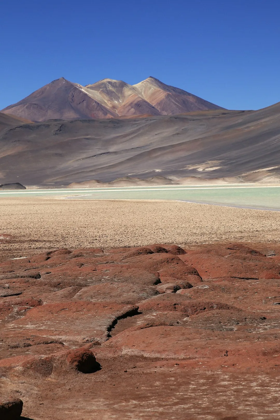
The visual spectacle of Laguna Verde itself is a major draw. Its intense turquoise hue, a result of high mineral content and algae, contrasts dramatically with the surrounding ochre and grey volcanic slopes and the often-brilliant blue sky. Depending on the wind, the surface of the laguna can be a mirror reflecting the surrounding peaks or a rippling expanse of colour. Other notable features include the nearby Ojos del Salar (Eyes of the Salt Flat), small, deep pools of water that appear in the middle of salt flats, and the geothermal activity that can be observed in the vicinity.
This trek is an immersion into a raw, untamed environment. It offers a unique opportunity to experience the grandeur of the high Andes, far from the usual tourist crowds, and to witness geological processes that continue to shape the planet. It is a journey that demands respect for the power of nature and rewards the intrepid with unforgettable vistas and a profound sense of accomplishment.
History and Cultural Context
The region surrounding Laguna Verde and Licancabur Volcano has a rich and ancient history, deeply intertwined with the indigenous peoples of the Andes. For millennia, these high-altitude areas were traversed by nomadic groups and later by more settled communities who understood and respected the harsh but resource-rich environment. The volcanoes, particularly Licancabur, held significant spiritual importance, often viewed as deities or powerful natural forces.
Archaeological evidence suggests that the Inca Empire extended its influence into this region, utilising the high passes for trade and communication. The presence of ancient Inca roads and settlements in the broader Atacama region points to a sophisticated understanding of the Andean landscape and its challenges. Licancabur itself has been the site of significant Inca ceremonial activity, with evidence of sacrifices and rituals conducted at its summit, underscoring its sacred status.
In more recent centuries, the area has been of interest for its mineral wealth, particularly salt and borax. The harsh conditions and remoteness, however, have largely preserved its natural state, making it a destination for those seeking extreme adventure and geological exploration rather than large-scale settlement or industry. The development of the Paso San Francisco border crossing has provided some access, but the Laguna Verde Circuit remains a frontier experience, largely untouched by mass tourism.
The cultural significance of this landscape continues today. Local communities and indigenous groups maintain a connection to these ancestral lands, and the preservation of this unique environment is a growing concern. The Laguna Verde Circuit offers a chance to connect with a landscape that has been shaped by both natural forces and human history over thousands of years.
Seasonal Highlights and Weather Reality
The best time to undertake the Laguna Verde Circuit is during the Southern Hemisphere summer, from November to March. This period offers the most stable weather conditions, with warmer temperatures and less chance of heavy snowfall on the passes. However, "warm" in this high-altitude desert environment is relative; daytime temperatures can be pleasant, but nights will be cold, often dropping below freezing.
Summer (November to March): This is the prime trekking season. Days are generally sunny with clear blue skies, offering excellent visibility of the surrounding volcanoes and landscapes. The risk of extreme weather events like blizzards is lower, though sudden storms can still occur. This is also the period when the colours of Laguna Verde are most vibrant due to the increased algae activity. However, this season also brings the highest risk of sandstorms, which can reduce visibility and make travel uncomfortable.
Shoulder Seasons (October and April): These months can offer a good balance, with fewer crowds than peak summer. However, the weather becomes more unpredictable. There's an increased chance of early or late snowfalls, particularly at higher elevations, and temperatures will be colder. Daylight hours are also shorter than in mid-summer.
Winter (May to September): This is generally considered the off-season for trekking in this region due to extreme cold, heavy snowfall, and hazardous road conditions. Passes can be blocked by snow for extended periods, and daytime temperatures may not rise above freezing. While the landscape can be stunningly beautiful under a blanket of snow, it is not recommended for trekking without specialised winter mountaineering experience and equipment.
General Weather Considerations: Regardless of the season, the weather in the high Andes is notoriously unpredictable and can change rapidly. Expect strong winds, significant temperature fluctuations between day and night, and intense solar radiation due to the high altitude and clear skies. Hypothermia is a significant risk, even in summer, due to the combination of altitude, wind chill, and potential for sudden storms. Always be prepared for a wide range of conditions.
Recommended Itinerary
4-Day Laguna Verde Circuit Itinerary
Day 1: Copiapó to Base Camp near Laguna Verde
- Distance: Approx. 250-300 km drive
- Elevation Gain: Significant drive, reaching over 4,000 m
- Time: 6-8 hours driving
- Start from Copiapó, heading east on Route 31 towards Paso San Francisco.
- The drive is long and passes through increasingly arid and high-altitude terrain.
- Road conditions can be rough, especially after the paved section ends; a 4x4 is highly recommended.
- Pass through the small settlement of Barrancas.
- Continue towards the border crossing area, aiming for a suitable camping spot near Laguna Verde.
- Set up camp at an altitude of approximately 4,300 metres.
- Focus on acclimatisation and resting after the long drive.
- Ensure all water and food supplies are secure.
Day 2: Laguna Verde Exploration and Acclimatisation Hike
- Distance: 8-10 km (hiking)
- Elevation Gain: 300-400 m
- Time: 4-5 hours
- Morning: Explore the immediate surroundings of Laguna Verde. Observe its vibrant colours and the imposing presence of Licancabur Volcano.
- Midday: Undertake a short acclimatisation hike to a nearby viewpoint or a lower volcanic cone. This helps the body adjust to the altitude.
- Afternoon: Return to base camp. Rest and hydrate. Prepare gear for the following days.
- Evening: Enjoy the spectacular sunset over the volcanic landscape.
- This day is crucial for acclimatisation before venturing to higher passes.
Day 3: Crossing the High Pass to the Other Side of the Circuit
- Distance: 12-15 km
- Elevation Gain: 600-800 m (cumulative, including ascents and descents)
- Time: 6-8 hours
- Early Morning: Depart from base camp, heading towards a high pass (e.g., around 4,800-5,000 m) that offers views across the wider volcanic plateau.
- The terrain will be rocky and potentially sandy, requiring careful footing.
- Navigate using GPS and map, as tracks may be indistinct.
- Descend into a new valley or basin on the opposite side of the initial circuit area.
- Find a suitable, sheltered campsite at a slightly lower elevation if possible, or at a similar altitude if no lower options are available.
- This is a physically demanding day due to altitude and terrain.
Day 4: Return towards Laguna Verde via Ojos del Salar
- Distance: 15-18 km
- Elevation Gain: 400-500 m (cumulative)
- Time: 6-7 hours
- Morning: Depart from the campsite, aiming to loop back towards the Laguna Verde area.
- The route may pass through salt flats and areas of geothermal interest.
- Visit the "Ojos del Salar" (Eyes of the Salt Flat) if they are on your planned route.
- Continue navigating through the volcanic landscape, keeping Licancabur in sight as a reference.
- Afternoon: Arrive back at the vicinity of Laguna Verde, potentially at a different point than the initial base camp.
- Set up final camp or prepare for the drive back to Copiapó if time and energy permit.
- Celebrate the completion of the circuit.
Day 5: Drive back to Copiapó
- Distance: Approx. 250-300 km drive
- Elevation Loss: Descending from high altitude
- Time: 6-8 hours driving
- Morning: Pack up camp and begin the long drive back to Copiapó.
- Ensure the vehicle is in good condition for the return journey.
- Take breaks as needed and enjoy the changing scenery as you descend.
Important Notes:
- This itinerary is a guideline; actual routes may vary based on conditions and navigation.
- Acclimatisation is critical. Consider spending an extra day at altitude before starting the trek if coming directly from sea level.
- Self-sufficiency is paramount: carry all food, water, fuel, shelter, and safety equipment.
- A reliable 4x4 vehicle is essential for accessing the trailhead and for potential emergencies.
- Carry a satellite communication device (e.g., PLB or satellite phone) as mobile signal is non-existent.
- Weather can change rapidly; be prepared for cold, wind, and potential snow.
Planning and Bookings
Book Your Trip
Everything you need to plan your journey
Accommodation
Find places to stay near Copiapó
Flights
Search flights to Copiapó
Essential Preparation
The Laguna Verde Circuit is a remote and challenging expedition that requires meticulous planning. The primary logistical challenge is reaching the trailhead near Laguna Verde, which is approximately 6-8 hours drive from Copiapó, much of it on rough, unpaved roads. A high-clearance 4x4 vehicle is not just recommended but essential for navigating these conditions and for any potential emergency situations. Ensure your vehicle is in excellent mechanical condition, with spare tyres, fuel, and basic repair tools.
Acclimatisation to altitude is the most critical aspect of personal preparation. The trek takes place between 4,000 and 5,000 metres, and attempting it without proper acclimatisation can lead to severe altitude sickness. It is highly advisable to spend at least 2-3 days in Copiapó (which is at sea level) or a higher altitude town like San Pedro de Atacama (around 2,400 m) before driving to the trailhead. Once at the trailhead, dedicate at least one full day to acclimatisation hikes and rest before embarking on the main circuit.
Given the remoteness, self-sufficiency is non-negotiable. You must carry all your food, water (or a reliable purification method), fuel for cooking, shelter (tent, sleeping bag, mat), navigation tools, and a comprehensive first-aid kit. Communication is also a major concern; there is no mobile phone coverage. A satellite communication device, such as a Personal Locator Beacon (PLB) or satellite phone, is strongly recommended for safety.
Trail Accommodation
This is a wilderness trek requiring camping. There are no established huts, lodges, or campsites along the Laguna Verde Circuit. Walkers must be fully self-sufficient and prepared to camp in remote, high-altitude environments.
Accommodation Type: Wild camping.
Booking Requirements: No bookings are required as there are no designated facilities. However, it is advisable to inform local authorities or a trusted contact of your planned route and expected return date.
Facilities Provided: None. You must carry all your own shelter, sleeping gear, and cooking equipment.
What's NOT Provided: Everything. This includes shelter, sleeping facilities, cooking equipment, food, water, toilets, and any form of assistance.
Seasonal Availability: Camping is possible year-round, but the summer months (November to March) offer the most favourable weather conditions. Winter camping is extremely challenging due to severe cold and potential snow cover.
Costs: There are no direct costs for accommodation, but the expense of purchasing and transporting all necessary camping and survival gear is significant.
Required Gear
- High-altitude trekking boots: Sturdy, waterproof, and well broken-in, offering ankle support.
- Backpack: A robust 60-75 litre pack with a good hip belt and rain cover.
- Tent: A 4-season tent capable of withstanding strong winds and potential snow.
- Sleeping bag: Rated to at least -10°C to -15°C comfort temperature, as nights will be very cold.
- Sleeping mat: Insulated mat for warmth and comfort.
- Waterproof and windproof outer layers: High-quality jacket and trousers (e.g., Gore-Tex or equivalent) are essential for protection against harsh weather.
- Insulating layers: Fleece or down jacket, thermal base layers (merino wool or synthetic).
- Warm hat and gloves: Wool or fleece, windproof outer gloves.
- Navigation tools: GPS device with pre-loaded maps, compass, and detailed topographic maps of the area. A backup navigation system is recommended.
- Head torch: With spare batteries.
- First-aid kit: Comprehensive kit including blister treatment, pain relievers, antiseptic wipes, bandages, and any personal medications. Include altitude sickness medication (e.g., Diamox) if recommended by your doctor.
- Sun protection: High SPF sunscreen (50+), lip balm with SPF, sunglasses (Category 3 or 4), wide-brimmed hat.
- Trekking poles: Highly recommended for stability on uneven terrain and to reduce strain on knees.
What to Bring
- Food: Lightweight, high-energy, non-perishable food for 4-5 days. Include breakfast, lunch, dinner, and plenty of snacks. Dehydrated meals are ideal.
- Water: Carry sufficient water or a reliable water filter/purification tablets. Water sources may be scarce or highly mineralised.
- Fuel: Sufficient fuel for your stove for the duration of the trek.
- Cooking equipment: Lightweight stove, pot, utensils, mug, bowl.
- Toiletries: Biodegradable soap, toothbrush, toothpaste, toilet paper, hand sanitiser, trowel for burying human waste (well away from water sources).
- Repair kit: Duct tape, cordage, needle and thread, multi-tool.
- Communication device: Satellite phone or Personal Locator Beacon (PLB) for emergencies.
- Camera: To capture the stunning scenery.
- Power bank: For charging electronic devices.
- Personal items: Book, journal, small towel.
Permits
As the Laguna Verde Circuit is a remote, undeveloped wilderness trek, there are generally no specific permits required for hiking or camping in the immediate vicinity of Laguna Verde or along the proposed circuit routes. The area is part of a vast, sparsely populated region of the Andes. However, it is always prudent to verify current regulations with local authorities in Copiapó or the Chilean National Forest Corporation (CONAF) before your trip, as regulations can change.
Vehicle Access: While no specific permit is needed for the trail itself, ensure your vehicle is legally registered and insured. If crossing international borders (e.g., towards Argentina or Bolivia, though not part of this circuit), specific vehicle permits and documentation would be required.
National Park Regulations: If your route takes you through any designated national parks or protected areas (which is less likely for this specific circuit but possible for broader exploration in the region), park entrance fees or specific camping permits might apply. However, the primary access points and the area around Laguna Verde are typically outside of formal park boundaries requiring such permits.
Recommendation: Before departing Copiapó, make an inquiry at the local tourism office or a CONAF office if one is accessible. They can provide the most up-to-date information on any local requirements or advisories. It is also wise to inform the local Carabineros (police) of your intended route and expected return date, especially given the remoteness and potential hazards.
Other Activities in the Area
While the Laguna Verde Circuit is the primary focus, the surrounding region offers several other compelling activities for those with time and a spirit of adventure:
- Ascent of Licancabur Volcano: For highly experienced mountaineers with proper acclimatisation and equipment, a guided ascent of Licancabur (5,920 m) is a significant undertaking. This requires a full day and involves technical climbing and extreme altitude. It is a challenging but rewarding experience, offering unparalleled views from the summit crater.
- Exploration of Ojos del Salar: These unique geological formations are small, perfectly circular pools of water that appear in the middle of vast salt flats. They are a fascinating natural phenomenon and a great spot for photography.
- Geothermal Areas: The volcanic nature of the region means there are often areas with geothermal activity, such as fumaroles or hot springs. These can be interesting to observe from a safe distance.
- Salar de Atacama Exploration: While further afield, a visit to the larger Salar de Atacama offers a different perspective on salt flats, with flamingo reserves and unique desert landscapes. This would typically be combined with a trip to San Pedro de Atacama.
- Stargazing: The high-altitude desert environment, with its clear skies and minimal light pollution, makes this region one of the best places in the world for stargazing. On clear nights, the Milky Way is incredibly vivid.
- Photography: The dramatic volcanic landscapes, vibrant colours of Laguna Verde, and vast salt flats provide endless opportunities for landscape photography.
Safety and Conditions
Altitude Sickness: This is the most significant risk. Symptoms can include headache, nausea, dizziness, fatigue, and shortness of breath. Prevention is key: ascend slowly, acclimatise properly, stay hydrated, and avoid alcohol and strenuous activity on arrival at altitude. If symptoms worsen, descend immediately.
Weather: Conditions can change rapidly. Be prepared for extreme cold, strong winds, sun exposure, and potential snow or hail, even in summer. Hypothermia is a serious risk. Always carry adequate warm clothing and waterproofs.
Navigation: Tracks can be indistinct or non-existent. A reliable GPS device with pre-loaded maps and a compass are essential. Do not rely solely on one navigation method. Inform someone of your route and expected return time.
Vehicle: A 4x4 vehicle is crucial. Ensure it is in excellent condition, with spare tyres, tools, and sufficient fuel. Road conditions can be very rough, and breakdowns in remote areas can be dangerous.
Water: Water sources may be scarce or contaminated. Carry sufficient water or a reliable purification method. Dehydration is a significant risk at altitude.
Remoteness: There is no mobile phone coverage. Carry a satellite communication device (PLB or satellite phone) for emergencies. Rescue services may be slow to reach you.
Sun Exposure: The high altitude means intense UV radiation. Use high SPF sunscreen, wear sunglasses and a hat, and protect your skin.
Geothermal Activity: Be cautious around any areas of geothermal activity; ground can be unstable and hot.
Travel Insurance: Ensure your travel insurance covers high-altitude trekking and emergency evacuation from remote areas.
Side Trips and Points of Interest
Licancabur Volcano (5,920 m): While a full ascent is a major expedition in itself, even viewing this iconic stratovolcano from various points around Laguna Verde is a highlight. Its near-perfect conical shape makes it one of the most recognisable peaks in the Andes. For experienced mountaineers, a guided ascent offers incredible views from its summit crater, which contains a small lake.
Ojos del Salar: These striking circular pools of water, appearing like eyes in the middle of vast salt flats, are a unique geological curiosity. They are often found in areas with underground water sources and are a testament to the diverse hydrological processes in the arid landscape.
Geothermal Vents: In certain areas around the volcanic complex, you may encounter fumaroles or steaming vents, indicating ongoing geological activity beneath the surface. These are fascinating to observe but should be approached with caution due to potential heat and unstable ground.
Laguna Verde's Colour Changes: The vibrant turquoise colour of Laguna Verde is due to its high mineral content and the presence of specific algae. The intensity of the colour can vary depending on light conditions, wind, and water levels, offering different visual experiences throughout the day and across seasons.
The Drive Itself: The journey to and from Laguna Verde is an adventure. The route passes through dramatic desert landscapes, high mountain passes, and offers glimpses of remote Andean life. The changing scenery, from the coastal plains near Copiapó to the high-altitude volcanic plateau, is a significant part of the experience.
Leave No Trace
The Laguna Verde Circuit traverses a fragile high-altitude desert ecosystem. Adhering to Leave No Trace principles is paramount to preserving this pristine environment for future visitors and for the ecological health of the region.
- Plan Ahead and Prepare: Research thoroughly, understand the conditions, and be prepared for self-sufficiency. Carry all necessary gear and food.
- Travel and Camp on Durable Surfaces: Stick to existing tracks where possible. If camping, choose established, hardened sites or areas with sparse vegetation. Avoid camping on fragile mosses or in areas prone to erosion.
- Dispose of Waste Properly: Pack out everything you pack in, including all food scraps, packaging, and toilet paper. Human waste should be buried at least 20 cm deep and 100 metres away from water sources, camp sites, and trails.
- Leave What You Find: Do not remove rocks, plants, or any natural or cultural artefacts. Take only photographs and memories.
- Minimise Campfire Impacts: Campfires are generally not recommended or permitted in this environment due to the scarcity of fuel and the risk of wildfire. Use a lightweight stove for cooking.
- Respect Wildlife: Observe wildlife from a distance and do not feed any animals. Their natural behaviours can be disrupted by human interaction.
- Be Considerate of Other Visitors: While this is a remote trek, if you do encounter others, maintain a respectful distance and minimise noise.
The high-altitude desert is slow to recover from damage. Your actions have a lasting impact. Tread lightly and responsibly.