Laguna San Rafael Trail
The Laguna San Rafael Trail is a challenging multi-day trek located in the Aysén Region of Chilean Patagonia. This remote and rugged route offers an immersive experience into the heart of the Patagonian wilderness, leading adventurers through diverse landscapes from dense temperate rainforests to windswept alpine meadows, culminating in breathtaking views of the San Rafael Glacier and its surrounding glacial lagoon. This trail is not for the faint of heart, demanding a high level of fitness, self-sufficiency, and preparedness for unpredictable weather conditions. It is a journey that rewards the intrepid with unparalleled solitude, raw natural beauty, and a profound connection to one of Earth's most spectacular glacial environments.
- Distance: 80.0 km
- Duration: 4-5 days
- Season: November to March (Southern Hemisphere Summer)
- Difficulty: Challenging
- Highest point: Approximately 1500 m
- Access: Fly to Balmaceda Airport (BBA), transfer to Puerto Aysén, then arrange transport to trailhead.
- Permits: Required, obtainable in Puerto Aysén.
Overview
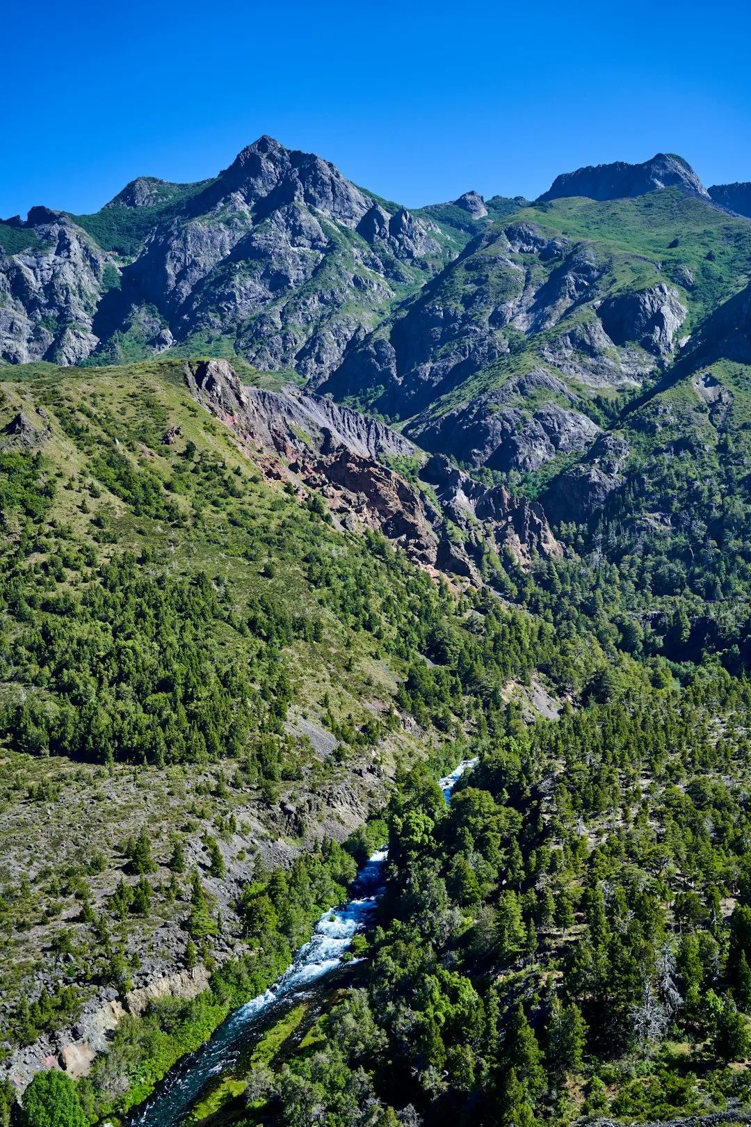
The Laguna San Rafael Trail is a testament to the wild, untamed beauty of Patagonia. This 80-kilometre journey is a significant undertaking, typically completed over four to five days, and is characterised by its demanding terrain and the sheer scale of its natural wonders. The trail begins its ascent from the fringes of the Aysén region's dense, ancient forests, where moss-draped trees and a symphony of bird calls create an almost mystical atmosphere. As the elevation gradually increases, the forest canopy begins to thin, giving way to more open, subalpine environments. Here, hardy vegetation clings to rocky slopes, and panoramic vistas of jagged peaks and distant ice fields start to unfold.
The true climax of the trek is the approach to Laguna San Rafael itself. This vast glacial lagoon is a dynamic and awe-inspiring spectacle, dominated by the immense San Rafael Glacier. The glacier, a colossal river of ice, calves icebergs of all shapes and sizes into the lagoon, creating a constantly shifting landscape of blues and whites. The sounds of the glacier—cracking ice, distant avalanches, and the thunderous roar of calving—are a powerful reminder of nature's immense forces. The trail often skirts the edges of the lagoon or offers elevated viewpoints, providing unforgettable perspectives of this glacial marvel.
This trail is a true wilderness experience. Unlike more developed national park trails, the Laguna San Rafael route requires a high degree of self-reliance. Navigation can be challenging, especially in adverse weather, and accommodation is typically limited to basic campsites or wild camping. The remoteness means that encounters with other hikers are infrequent, offering a profound sense of solitude and immersion in nature. The weather in Patagonia is notoriously fickle, with conditions capable of changing from brilliant sunshine to driving rain and high winds within hours. Hikers must be prepared for all eventualities, carrying appropriate gear and maintaining a flexible mindset.
History and Cultural Context
The Aysén Region, where the Laguna San Rafael Trail is located, has a rich history shaped by indigenous peoples, early explorers, and hardy settlers. For millennia, the indigenous Kawésqar and Tehuelche peoples navigated these lands and waters, their lives intrinsically linked to the natural environment. Their knowledge of the terrain, weather patterns, and resources was essential for survival in this challenging climate. While direct evidence of extensive trail use by these groups along the specific route of Laguna San Rafael may be limited, their presence and deep connection to the broader Patagonian landscape are undeniable.
European exploration of Patagonia began in earnest during the Age of Discovery, with navigators charting the coastlines and seeking passages through the labyrinthine fjords. The San Rafael Glacier itself was first documented by the Spanish explorer Bruno Mauricio de Zabala in 1741, though it was later charted more extensively by other expeditions. The establishment of permanent settlements in Aysén is a more recent phenomenon, largely driven by sheep farming and resource extraction in the late 19th and early 20th centuries. The development of infrastructure, including rudimentary roads and trails, was a slow and arduous process, often undertaken by pioneers with immense resilience.
The creation of national parks and protected areas, including the Bernardo O'Higgins National Park (which encompasses the San Rafael Glacier), has been crucial in preserving these wild landscapes. The Laguna San Rafael Trail, while not a formally managed "Great Walk" like its New Zealand counterparts, represents a path forged through this history—a route that allows modern adventurers to experience the raw, remote beauty that has captivated explorers and inhabitants for centuries. The trail's challenging nature reflects the historical difficulty of traversing this region, a testament to the enduring power of the Patagonian wilderness.
Seasonal Highlights and Weather Reality
The optimal season for hiking the Laguna San Rafael Trail is during the Southern Hemisphere's summer, from November to March. This period offers the highest probability of encountering more favourable weather conditions, although "favourable" in Patagonia is a relative term.
Summer (November to March): This is the primary hiking season. Days are longer, providing more daylight hours for trekking. Temperatures are generally milder, typically ranging from 5°C to 15°C, though frost and even light snow can occur at higher elevations, especially in November and March. The vegetation is at its most vibrant, and wildlife may be more active. However, this is also the season when sandflies can be most prevalent, particularly in sheltered, damp areas. Rain is a constant possibility, and strong winds are common. The San Rafael Glacier is a year-round spectacle, but summer offers the best chance of clear views and accessible trail conditions.
Shoulder Seasons (October and April): These months can offer a mixed bag. October may still see significant snow at higher elevations, making the trail difficult or impassable without winter gear and experience. April brings the onset of autumn, with potentially stunning fall colours in the forests, but also a higher likelihood of colder temperatures, increased rainfall, and earlier snowfall. The days are shorter, and the risk of severe weather increases.
Winter (May to September): This period is generally unsuitable for hiking the Laguna San Rafael Trail. Heavy snowfall, extreme cold, high winds, and limited daylight make the route dangerous and largely impassable for most hikers. Access to trailheads may also be severely restricted due to snow and ice.
Regardless of the season, hikers must be prepared for rapid weather changes. The Patagonian climate is renowned for its unpredictability. It is not uncommon to experience sunshine, rain, wind, and even sleet all within a single day. Flexibility and robust gear are paramount for a safe and enjoyable experience.
Recommended Itinerary
4-Day Laguna San Rafael Trail Itinerary
Day 1: Trailhead to Campamento Río Oscuro
- Distance: 15 km
- Elevation gain: 400 m
- Time: 5–7 hours
- Start at the designated trailhead near Lago Atravesado.
- Initial section through dense Valdivian temperate rainforest, following a marked but often rough path.
- Ascend gradually, with occasional steep sections and stream crossings.
- The forest canopy provides some shelter, but expect damp conditions.
- Arrive at Campamento Río Oscuro, a designated or wild camping spot along the Río Oscuro.
- Set up camp and prepare dinner.
- This day focuses on acclimatising to the terrain and the Patagonian wilderness.
Day 2: Campamento Río Oscuro to Campamento Alto Nevado
- Distance: 20 km
- Elevation gain: 600 m
- Time: 6–8 hours
- Continue ascending out of the dense forest into more open subalpine terrain.
- The trail becomes less defined in places, requiring careful navigation.
- Pass through areas of scrubland and rocky scree.
- Enjoy increasingly expansive views of surrounding peaks and valleys.
- Arrive at Campamento Alto Nevado, a high-altitude camping area offering potential views towards the glacial region.
- This is a physically demanding day with significant elevation gain.
- Be prepared for exposure to wind and changing weather.
Day 3: Campamento Alto Nevado to Laguna San Rafael Viewpoint Camp
- Distance: 25 km
- Elevation gain: 500 m
- Time: 7–9 hours
- The most challenging day, involving crossing a high pass and descending towards the glacial lagoon.
- Navigate across alpine meadows and potentially snowfields, depending on the season.
- Reach the highest point of the trek, offering dramatic vistas of the glaciated landscape.
- Begin the descent towards Laguna San Rafael.
- Arrive at a designated or suitable wild camping spot with views of the lagoon and glacier.
- This day is highly dependent on weather conditions for visibility and safety.
- The sheer scale of the glacial environment becomes apparent.
Day 4: Laguna San Rafael Exploration and Return to Campamento Río Oscuro
- Distance: 20 km (return to Río Oscuro)
- Elevation loss: 500 m
- Time: 6–8 hours
- Spend the morning exploring the immediate vicinity of Laguna San Rafael. Observe the glacier calving and the icebergs floating in the lagoon.
- Begin the return journey, retracing your steps back towards Campamento Río Oscuro.
- This allows for a different perspective on the landscape and potentially better weather for the descent.
- Arrive back at Campamento Río Oscuro, setting up camp for the final night.
- Reflect on the incredible journey and the power of the glacial environment.
Day 5 (Optional): Return to Trailhead
- Distance: 15 km
- Elevation loss: 400 m
- Time: 4–6 hours
- Complete the descent back to the trailhead.
- This extra day provides flexibility for weather delays or allows for a more relaxed pace on the final descent.
Important Notes:
- This itinerary is a guideline; actual timings and distances may vary based on conditions and individual pace.
- Wild camping is common; ensure you are familiar with Leave No Trace principles and local regulations.
- Navigation skills are essential; carry a map, compass, and GPS device.
- Water sources are generally plentiful but should be treated.
- Be prepared for significant elevation changes and exposure to the elements.
Planning and Bookings
Book Your Trip
Everything you need to plan your journey
Accommodation
Find places to stay near Puerto Aysén
Flights
Search flights to Puerto Aysén
Essential Preparation
The Laguna San Rafael Trail is a remote expedition requiring meticulous planning. Given its challenging nature and limited infrastructure, thorough preparation is paramount. The closest major town and logistical hub is Puerto Aysén. Access to the trailhead typically involves a significant journey from Puerto Aysén, often requiring a 4x4 vehicle due to unpaved and potentially rough road conditions. It is advisable to arrange private transfers or hire a suitable vehicle in Puerto Aysén. Limited parking is available at the trailhead, so confirm availability in advance. Permits are mandatory and must be obtained from the relevant authorities in Puerto Aysén before commencing the trek. It is crucial to check weather forecasts extensively before departure and have contingency plans for delays or changes in conditions. Informing someone of your itinerary and expected return date is a vital safety measure.
Trail Accommodation
This is a challenging multi-day hike requiring overnight accommodation. The trail does not feature established huts or lodges in the same way as more developed national park tracks. Accommodation primarily consists of designated camping areas or wild camping spots along the route. Hikers must be entirely self-sufficient and carry all necessary camping equipment.
Camping Facilities:
- Designated camping areas may offer basic amenities such as a flat area for tents and potentially a rudimentary shelter or pit toilet. These are not guaranteed and vary significantly along the route.
- Wild camping is permitted in many areas, provided hikers adhere to Leave No Trace principles and respect the natural environment.
- Campers must be prepared to carry all their gear, including tents, sleeping bags, and cooking equipment.
What's NOT Provided:
- No food or water supplies are available on the trail.
- No cooking facilities, fuel, or equipment are provided.
- No electricity or charging points.
- No bedding or mattresses.
- No waste disposal facilities – all rubbish must be packed out.
Seasonal Availability: Camping is possible throughout the recommended hiking season (November to March). Outside this period, snow and extreme weather may make camping unsafe or impossible.
Costs: While there are no specific booking fees for wild camping spots, there may be park entrance fees or permit costs associated with accessing the area, which should be confirmed in Puerto Aysén. Designated camping areas, if they exist, might incur a small fee.
Required Gear
- Sturdy, waterproof hiking boots: Essential for navigating varied and often wet terrain. Ensure they are well broken-in.
- Waterproof and windproof jacket and trousers: High-quality, breathable materials (e.g., Gore-Tex) are crucial due to Patagonia's unpredictable weather.
- Warm layers: Including thermal base layers (merino wool or synthetic), fleece or down mid-layers, and a warm hat and gloves. Temperatures can drop significantly, especially at higher elevations.
- Sleeping bag: Rated for sub-zero temperatures (e.g., -5°C to -10°C comfort rating) is recommended, as nights can be cold.
- Backpack: A robust, comfortable pack of 60-75 litres capacity, with a waterproof cover.
- Tent: A sturdy, three-season tent capable of withstanding strong winds and rain.
- Navigation tools: Detailed topographic map of the area, a reliable compass, and a GPS device or smartphone with offline maps and a power bank. Knowledge of how to use them is vital.
- Head torch: With spare batteries, as daylight hours can be limited, and for use in camp.
- First-aid kit: Comprehensive, including blister treatment, pain relievers, antiseptic wipes, bandages, and any personal medications.
- Sun protection: High SPF sunscreen, sunglasses, and a wide-brimmed hat, as the sun can be intense even on cloudy days.
- Insect repellent: Particularly effective against sandflies (look for products with DEET or Picaridin).
What to Bring
- Food: Lightweight, high-energy, non-perishable food for 4-5 days, including breakfast, lunch, dinner, and plenty of snacks. Plan meals carefully to minimise weight.
- Water treatment: A reliable water filter or purification tablets. While water sources are generally abundant, treating all water is recommended.
- Cooking equipment: Lightweight camping stove, fuel, cooking pot, utensils, mug, and a bowl.
- Toiletries: Biodegradable soap, toothbrush, toothpaste, toilet paper, hand sanitiser, and a small trowel for burying human waste if no facilities are available.
- Repair kit: Duct tape, cordage, needle and thread, and a multi-tool for gear repairs.
- Trekking poles: Highly recommended for stability on uneven terrain and for reducing strain on knees during descents.
- Dry bags: To keep essential gear (clothing, electronics, sleeping bag) dry inside your backpack.
- Personal items: Camera, journal, book, and any personal comfort items.
- Cash: For any unexpected expenses or local services in Puerto Aysén.
Permits

Access to the Laguna San Rafael Trail and the surrounding national park areas requires specific permits. These are typically obtained from the National Forest Corporation (CONAF) or designated park authorities in Puerto Aysén. It is essential to confirm the exact permit requirements and the process for obtaining them well in advance of your trip. This may involve visiting an office in person, submitting an application, or potentially booking online if such systems are in place.
Permit Acquisition:
- Location: Permits are generally issued in Puerto Aysén. It is advisable to visit the CONAF office or the local tourism information centre upon arrival in the town.
- Timing: Obtain your permits as soon as possible after arriving in Puerto Aysén. Do not leave this until the last minute, as processing times can vary, and availability may be limited, especially during peak season.
- Documentation: You may need to provide identification, details of your itinerary, and proof of your hiking experience or qualifications, especially for more remote or challenging routes.
- Fees: There will likely be a fee associated with the permit, which contributes to the maintenance and protection of the national park.
Trailhead Access and Road Conditions: The road leading to the trailhead near Lago Atravesado is often unpaved and can be in poor condition, especially after rain. A 4x4 vehicle is highly recommended, or alternatively, arranging a specialised transfer service from Puerto Aysén is advisable. Limited parking is available at the trailhead, so confirm its availability and any associated regulations.
Safety Briefing: When obtaining your permit, take the opportunity to ask park authorities about current trail conditions, weather forecasts, and any specific safety advisories. They can provide invaluable up-to-date information that is crucial for a safe expedition.
No specific booking system for campsites exists as much of the accommodation is wild camping. However, if designated camping areas are present, it is wise to inquire about any reservation requirements.
Other Activities in the Area
The Aysén Region offers a wealth of activities for those looking to extend their Patagonian adventure beyond the Laguna San Rafael Trail:
- San Rafael Glacier Boat Tour: For those who prefer not to hike to the glacier, boat tours depart from Puerto Chacabuco or Puerto Montt, offering a comfortable way to witness the San Rafael Glacier and its lagoon. These tours provide close-up views of the ice and opportunities to see marine wildlife.
- Cerro Castillo National Park: Located south of Puerto Aysén, this park offers spectacular hiking opportunities, including the challenging multi-day trek to Laguna Cerro Castillo, renowned for its turquoise waters and dramatic mountain backdrop.
- Patagonia General Carrera Lake: Explore the vast General Carrera Lake, shared with Argentina. Highlights include the Marble Caves (Capillas de Mármol), accessible by boat from Puerto Río Tranquilo, where sculpted marble formations create stunning natural art.
- Queulat National Park: Further north, this park features the Ventisquero Colgante (Hanging Glacier), a dramatic ice field that cascades down a sheer cliff face, creating a spectacular waterfall.
- Puerto Aysén and Surrounding Fjords: Explore the town of Puerto Aysén, known for its picturesque fjord setting and the nearby Los Colonias waterfall. Boat trips can explore the intricate network of fjords, offering opportunities for wildlife spotting (whales, dolphins, sea lions).
- Futaleufú River: For adrenaline seekers, the Futaleufú River is world-renowned for its exceptional whitewater rafting and kayaking opportunities.
- Estancias and Sheep Farming: Experience the traditional Patagonian way of life by visiting a working estancia (ranch), learning about sheep farming, and enjoying local cuisine.
Safety and Conditions
Pre-Departure Checks:
- Weather: Consult multiple reliable weather forecasts for the Aysén region and specifically for the higher elevations near Laguna San Rafael. Be prepared for rapid changes and extreme conditions. MetService or local Chilean meteorological services are good resources.
- Trail Conditions: Contact CONAF or local park authorities in Puerto Aysén for the most up-to-date information on trail status, snow levels, river crossings, and any potential hazards.
- Road Access: Verify the condition of the road to the trailhead. Unpaved roads can become impassable after heavy rain or snow.
- Communication: Inform a reliable contact person of your detailed itinerary, expected return date, and emergency procedures. Mobile phone reception is virtually non-existent on the trail. Consider carrying a Personal Locator Beacon (PLB) or satellite messenger for emergencies.
Key Hazards:
- Unpredictable Weather: Patagonia is notorious for its volatile weather. High winds, heavy rain, sleet, fog, and sudden temperature drops are common, even in summer. Hypothermia is a significant risk.
- Navigation: The trail can be poorly marked or indistinct in places, especially at higher elevations. Strong navigation skills using map, compass, and GPS are essential. Getting lost is a serious danger.
- River Crossings: Several river crossings may be encountered. Water levels can rise rapidly after rain, making crossings dangerous or impossible. Assess each crossing carefully and do not attempt if the water appears too swift or deep.
- Exposure: At higher elevations, hikers are exposed to harsh elements with little shelter. Wind chill can make temperatures feel much colder than they are.
- Sandflies: During warmer months, sandflies can be a significant nuisance. They are most active at dawn and dusk and in sheltered, damp areas.
- Wildlife: While large predators are rare, be aware of your surroundings.
- Remoteness: Rescue operations in remote areas can be slow and difficult. Self-sufficiency and preparedness are critical.
Recommended Safety Measures:
- Hike with a partner: Never hike alone on this trail.
- Carry appropriate gear: Ensure all equipment is in good condition and suitable for alpine conditions.
- Pace yourself: Allow ample time for each day's hike, factoring in potential delays due to weather or terrain.
- Stay hydrated and fuelled: Drink plenty of water and eat regularly to maintain energy levels.
- Know your limits: Be prepared to turn back if conditions become too dangerous or if you are not adequately prepared.
Travel insurance is strongly recommended to cover potential medical emergencies, evacuation, and trip cancellations.
Side Trips and Points of Interest
Laguna San Rafael Glacier and Lagoon: The primary destination and highlight of the trek. Spend ample time observing the immense San Rafael Glacier, a tidewater glacier that calves icebergs into the lagoon. The ever-changing spectacle of icebergs, the deep blue hues of the glacial ice, and the sheer scale of the glacier are awe-inspiring. Listen for the sounds of the ice cracking and calving – a powerful reminder of glacial dynamics.
Alpine Passes and Viewpoints: The trek involves ascending and descending several alpine passes. These offer panoramic vistas of the surrounding Patagonian Andes, including jagged peaks, vast ice fields, and deep valleys. The highest points of the trek provide breathtaking, expansive views that are a reward in themselves.
Valdivian Temperate Rainforest: The initial sections of the trail wind through dense, ancient Valdivian temperate rainforest. Characterised by a high diversity of flora, including coigüe, lenga, and ñire trees, often draped in mosses and epiphytes. The rich undergrowth of ferns and shrubs creates a lush, primeval atmosphere. Keep an eye out for native birdlife.
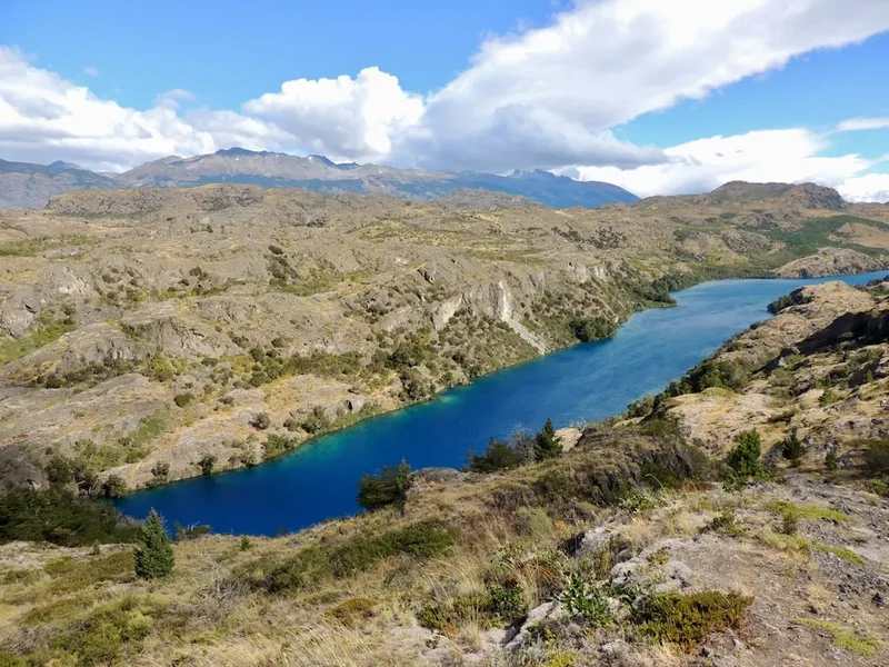
Río Oscuro and Río Baker Valleys: The trail follows or traverses the valleys of these glacial rivers. Their turquoise or milky-blue waters, coloured by glacial silt, are a striking feature of the Patagonian landscape. The power and beauty of these rivers are evident as you hike alongside them.
Potential for Wildlife Sightings: While not guaranteed, keep an eye out for native Patagonian wildlife. This can include various bird species, such as condors soaring overhead, and potentially guanacos or other mammals in the more open alpine areas. Marine life may be visible from the lagoon if boat tours are taken.
Leave No Trace
The Laguna San Rafael Trail traverses a pristine and fragile wilderness area. Adhering to Leave No Trace (LNT) principles is not just recommended; it is essential for preserving this environment for future generations and for the safety of all who venture here. The remoteness and limited infrastructure mean that the impact of each visitor is magnified.
Your responsibility as a hiker:
- Plan Ahead and Prepare: Research the trail thoroughly, understand the conditions, and pack appropriately. Inform someone of your plans.
- Travel and Camp on Durable Surfaces: Stick to established trails where they exist. If wild camping, choose sites that are already impacted or on durable surfaces like rock or gravel, well away from water sources. Avoid trampling vegetation.
- Dispose of Waste Properly: Pack out everything you pack in, including all food scraps, wrappers, and toilet paper. Use designated toilets where available. If not, dig catholes at least 60 metres (60 m) away from water, trails, and campsites, and bury human waste and toilet paper.
- Leave What You Find: Do not remove plants, rocks, or any natural objects. Do not build structures or dig trenches.
- Minimise Campfire Impacts: Campfires are generally discouraged or prohibited in many sensitive wilderness areas due to the risk of wildfires and long-term damage. Use a lightweight stove for cooking. If a fire is absolutely necessary and permitted, use existing fire rings and ensure it is completely extinguished.
- Respect Wildlife: Observe wildlife from a distance. Never feed animals, as it can harm their health, alter their natural behaviours, and expose them to human-related diseases. Store food securely to prevent attracting animals.
- Be Considerate of Other Visitors: While this trail offers solitude, be mindful of other hikers you may encounter. Keep noise levels low and yield to others on the trail.
By following these principles, you help ensure that the Laguna San Rafael Trail remains a wild and beautiful place for years to come. Tread lightly, be prepared, and leave no trace of your passage.