Laguna 69 Trek - The Turquoise Jewel of the Cordillera Blanca
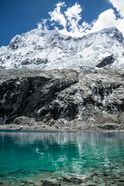
The Laguna 69 Trek is arguably the most iconic day hike in Peru, a breathtaking journey into the heart of the Huascarán National Park. Situated at a staggering 4,600 metres above sea level, this glacial lake is world-renowned for its brilliant, almost neon-turquoise waters, framed by the jagged, snow-capped peaks of the Cordillera Blanca. The trail is a 13-kilometre round trip that challenges even the most seasoned hikers, not necessarily due to its technicality, but because of the thin Andean air. Starting at Cebollapampa (3,900 metres), the route winds through high-altitude meadows, past cascading waterfalls, and beneath the shadows of some of the highest mountains in the tropics, including Huascarán, Chopicalqui, and Chacraraju. This is more than just a walk; it is a rite of passage for trekkers visiting Huaraz, offering a concentrated dose of alpine beauty that rivals any multi-day expedition in the Andes.
- Distance: 13.0 km return
- Duration: 5–7 hours
- Elevation Gain: 750 m
- Highest Point: 4,600 m (Laguna 69)
- Difficulty: Challenging (primarily due to altitude)
- Best Time: May to September (Andean dry season)
- Closest City: Huaraz, Ancash Region, Peru
- Trailhead: Cebollapampa, Huascarán National Park
Overview
The Laguna 69 Trek is a masterclass in high-altitude scenery. While many hikers come to Peru specifically for the Inca Trail or the Salkantay Trek, those who venture north to the Ancash region often find that Laguna 69 provides the most visually arresting single day of their entire journey. The trek is located within the UNESCO-listed Huascarán National Park, a protected area that encompasses nearly the entire Cordillera Blanca—the highest tropical mountain range in the world. The landscape here is defined by dramatic contrasts: the lush, green valley floor of Cebollapampa, the silver-grey granite of the mountain walls, and the blinding white of the glaciers that feed the lake.
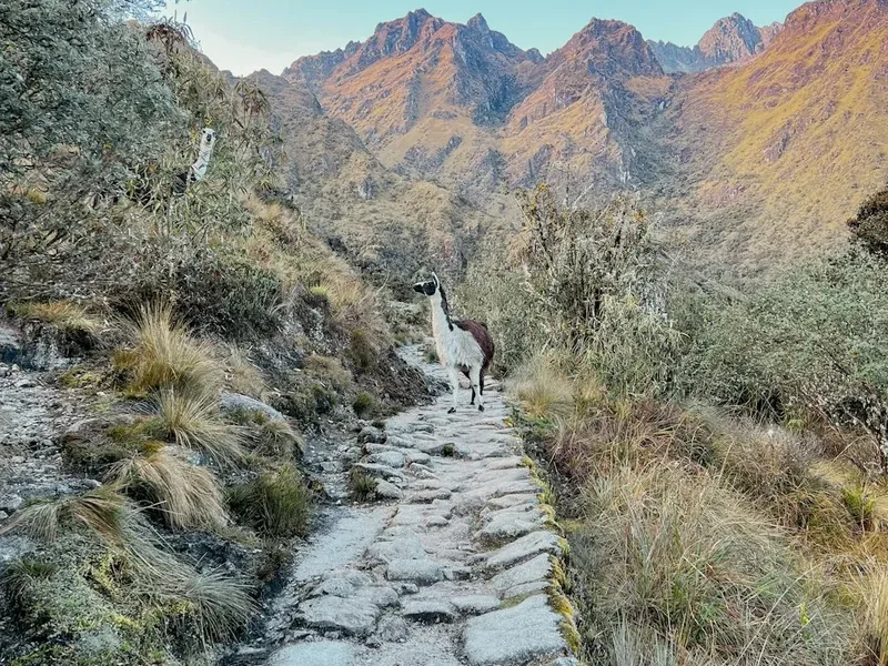
The hike is traditionally completed as a day trip from Huaraz, requiring an early start and a significant amount of physical resolve. The trail begins relatively gently, following a meandering stream through a valley populated by grazing cattle and hardy Polylepis trees—ancient, gnarled trees that are among the few species capable of surviving at such extreme altitudes. However, the "gentle" start is deceptive. As the trail begins to climb, the oxygen levels drop significantly, making every step feel twice as heavy. The final section, often referred to as "the wall," consists of a series of steep switchbacks that test the mental fortitude of every hiker. The reward, however, is unparalleled. Reaching the crest of the final ridge reveals the lake in all its glory—a shimmering pool of crystalline blue sitting directly at the base of the Chacraraju glacier.
Because of its popularity, the trail can be busy during the peak months of July and August. However, the sheer scale of the surrounding mountains—many of which exceed 6,000 metres—ensures that the sense of wilderness remains intact. The trek is not just about the destination; it is about the journey through a landscape that feels prehistoric and raw. From the thundering waterfalls that drop hundreds of metres from hanging glaciers to the curious vizcachas (Andean rodents resembling long-tailed rabbits) that dart among the rocks, Laguna 69 is a sensory explosion that demands respect and rewards effort in equal measure.
History and Cultural Context
The history of Laguna 69 is inextricably linked to the broader history of the Huascarán National Park and the exploration of the Cordillera Blanca. Unlike many trails in the Cusco region, Laguna 69 does not lead to ancient Incan ruins. Instead, its significance is geological and environmental. The lake itself is a relatively recent feature in geological terms, formed by the retreat of the Chacraraju glacier. Its name, "Laguna 69," is a reflection of the systematic mapping of the region. When the Huascarán National Park was being formally organised and its hundreds of glacial lakes were being catalogued in the mid-20th century, this particular lake was the 69th on the list. While many other lakes in the park have traditional Quechua names—such as Llanganuco or Querococha—the numerical designation of Laguna 69 has stuck, becoming a brand of its own in the global hiking community.
The region is the ancestral home of the Ancash people, who have lived in the shadows of these peaks for millennia. To the local Quechua-speaking communities, the mountains (or 'Apus') are sacred deities. Huascarán, the highest peak in Peru at 6,768 metres, is seen as a powerful protector. The valleys surrounding Laguna 69 were historically used for high-altitude grazing, and you will still see local herders moving cattle through the Cebollapampa area today. The establishment of the Huascarán National Park in 1975 and its subsequent designation as a UNESCO World Heritage site in 1985 marked a turning point for the region, shifting the focus toward conservation and regulated tourism.
In recent decades, Laguna 69 has also become a focal point for climate change research. The glaciers of the Cordillera Blanca are retreating at an alarming rate, and the very existence of the lake is a testament to this process. Hikers today are witnessing a landscape in transition; the ice that feeds the turquoise waters is significantly smaller than it was even twenty years ago. This adds a layer of poignancy to the trek, as visitors realise they are seeing a fragile ecosystem that may look very different for future generations.
Want more background? Read extended notes on history and cultural context → Learn more
Seasonal Highlights and Weather Reality
The weather in the Peruvian Andes is divided into two distinct seasons: the dry season (Andean Summer) and the wet season (Andean Winter). Understanding these cycles is crucial for a successful and safe trek to Laguna 69.
Dry Season (May to September): This is the prime window for trekking. During these months, you can expect stable weather, clear blue skies, and crisp mountain air. The visibility is at its peak, offering the best views of the surrounding peaks like Huandoy and Pisco. However, "dry" does not mean "warm." While the sun is incredibly intense at 4,600 metres, temperatures can drop below freezing at night and in the early morning. Hikers starting at dawn will often encounter frost on the ground at Cebollapampa. This is also the busiest time of year, so expect more company on the trail.
Shoulder Seasons (April and October): These months can be a gamble. You may experience beautiful, clear mornings followed by afternoon rain or snow. The landscape is often greener during these months as the rains begin or end, and the trail is significantly quieter. If you are an experienced hiker who doesn't mind a bit of mud, the shoulder season can be a rewarding time to visit.
Wet Season (November to March): Trekking to Laguna 69 during the height of the wet season is generally discouraged for casual hikers. Heavy rain, thick fog, and snow at higher elevations are common. The trail can become dangerously slippery, and the spectacular views of the glaciers are often obscured by clouds. Furthermore, the turquoise colour of the lake—its most famous feature—can appear dull or grey under overcast skies. However, for those who do venture out during a break in the weather, the mountains are at their most dramatic, draped in fresh snow and surrounded by lush, vibrant vegetation.
Regardless of the season, weather at 4,600 metres is notoriously unpredictable. A perfectly clear morning can transform into a localized snowstorm within thirty minutes. Always carry waterproof layers and be prepared for rapid temperature fluctuations.
Recommended Itinerary
Laguna 69 Day Trek Itinerary
Early Morning: Departure from Huaraz
- 05:00 – 05:30: Pick up from accommodation in Huaraz.
- 05:30 – 07:30: Drive north through the Callejon de Huaylas valley, passing through the towns of Carhuaz and Yungay.
- 07:30 – 08:15: Enter Huascarán National Park and drive up the Llanganuco Gorge.
- 08:15 – 08:45: Brief stop at the Llanganuco Lakes (Chinancocha and Orconcocha) for photos and a quick breakfast.
- 09:00: Arrive at Cebollapampa (3,900 m), the official trailhead.
Morning: The Ascent Begins
- 09:00 – 10:30: Begin the hike through the flat valley floor of Cebollapampa. This section follows a glacial stream and is relatively easy, allowing for a final warm-up.
- 10:30 – 11:30: The first major climb. The trail begins to zigzag up the side of the valley. You will pass a spectacular waterfall on your right and gain views of the peaks of Huandoy.
- 11:30 – 12:15: Reach the first plateau. This is a high-altitude meadow where the trail flattens out again. You will pass a small, unnamed lake (often called Laguna 68) which serves as a good spot for a short rest.
Midday: The Final Push to the Lake
- 12:15 – 13:15: The final ascent. This is the steepest and most challenging part of the trek, consisting of tight switchbacks on a rocky slope. The air is very thin here, and most hikers will need to stop frequently to catch their breath.
- 13:15 – 14:00: Arrive at Laguna 69 (4,600 m). Spend time taking photos, eating lunch, and marvelling at the Chacraraju glacier. The water is freezing, but some brave souls opt for a very quick (and very cold) dip.
Afternoon: The Descent and Return
- 14:00 – 16:00: Begin the descent back to Cebollapampa. While easier on the lungs, the descent is hard on the knees. Take your time on the rocky sections.
- 16:00 – 16:30: Arrive back at the trailhead at Cebollapampa.
- 16:30 – 19:00: Return drive to Huaraz, typically arriving back at your accommodation in the early evening.
Important Notes:
- This is a high-altitude trek; do not attempt this on your first day in Huaraz.
- The total walking time is usually 6 hours (3.5–4 hours up, 2 hours down).
- Ensure you have arranged transport back to Huaraz, as colectivos (shared vans) from Cebollapampa become scarce after 16:30.
- Stay hydrated and move at a steady, sustainable pace.
Planning and Bookings
Book Your Trip
Everything you need to plan your journey
Accommodation
Find places to stay near Huaraz
Flights
Search flights to Huaraz
Essential Preparation
The single most important factor in planning your Laguna 69 trek is acclimatisation. Huaraz sits at 3,052 metres, which is already high enough to cause symptoms of altitude sickness. Laguna 69, at 4,600 metres, is significantly higher. It is strongly recommended that you spend at least two to three days in Huaraz before attempting this hike. During these days, undertake shorter, lower-altitude walks such as the hike to Laguna Wilcacocha (3,700 m) or the Pastoruri Glacier (which is high but requires very little walking). Physical fitness is important, but altitude is the great equaliser; even marathon runners can struggle if they haven't acclimatised properly.
Logistically, Huaraz is the perfect base. It is a bustling mountain city with a wide range of accommodation, from budget hostels to comfortable hotels. There are numerous outdoor shops where you can rent gear, and the central market is excellent for stocking up on high-energy snacks. Most people book their Laguna 69 trek through one of the many agencies in town, which typically includes transport and a guide. Alternatively, you can take a public colectivo toward Yanama and ask to be dropped at Cebollapampa, though this requires more careful timing for the return journey.
Trail Accommodation
This is a day hike requiring no overnight accommodation on the trail itself. Camping is technically permitted at Cebollapampa for those who wish to start their hike very early or combine it with the Pisco Base Camp trek, but there are no formal facilities other than flat ground and the river. Most hikers stay in Huaraz and travel to the trailhead and back in a single day.
Huaraz Accommodation Options:
- Hostels: Numerous options catering to trekkers, often with communal kitchens and gear storage.
- Hotels: Mid-range options providing more comfort and private bathrooms.
- Mountain Lodges: Some higher-end lodges are located on the outskirts of Huaraz, offering quieter environments and stunning mountain views.
Facilities at Cebollapampa:
- Basic pit toilets are usually available near the trailhead.
- No running water (other than the river).
- No food or supplies available for purchase; you must bring everything from Huaraz.
Required Gear
- Hiking boots: Sturdy, waterproof boots with good ankle support are essential for the rocky terrain.
- Layered clothing: A moisture-wicking base layer, an insulating fleece or down jacket, and a waterproof/windproof outer shell.
- Trekking poles: Highly recommended to assist with the steep ascent and to protect your knees during the 750-metre descent.
- Daypack: A 20–30 litre pack with a rain cover.
- Sun protection: High-SPF sunscreen, lip balm with SPF, a wide-brimmed hat, and UV-protection sunglasses (the Andean sun is exceptionally strong).
- Head torch: Always carry one in case your descent takes longer than expected.
- Gloves and beanie: Essential for the cold temperatures at the lake and the early morning start.
What to Bring
- Water: At least 2–3 litres per person. Hydration is key to combating altitude sickness.
- Water treatment: If you plan to refill from the stream, use a filter or purification tablets (cattle graze in the area).
- High-energy food: Pack a lunch and plenty of snacks like nuts, chocolate, dried fruit, and energy bars.
- Coca leaves or sweets: A traditional Andean remedy for altitude; chewing leaves or sucking on coca candies can provide a mild stimulant effect and help with nausea.
- Personal first aid: Include blister plasters, ibuprofen/paracetamol, and any personal medications.
- Cash: Small denominations of Peruvian Soles for the National Park entrance fee and any tips for guides or drivers.
- Toilet paper and hand sanitiser: Facilities are minimal; be prepared to pack out any used paper.
Permits
To hike to Laguna 69, you must enter the Huascarán National Park, which requires a permit. Unlike the Inca Trail, there is no limit on the number of daily visitors, and you do not need to book months in advance. However, you must ensure you have the correct ticket.
Permit Options and Costs:
- Daily Pass: S/30 (approximately US$8). This is valid for a single day and is the standard choice for the Laguna 69 trek.
- Multi-Day Pass (up to 3 days): S/60 (approximately US$16). Ideal if you plan to do another hike within the park shortly after, such as the Santa Cruz Trek.
- Long-Stay Pass (up to 30 days): S/150 (approximately US$40). Best for serious trekkers planning multiple expeditions.
How to Purchase:
- Permits are typically purchased at the park entrance control point in the Llanganuco Gorge as you drive toward the trailhead.
- If you are travelling with an organised tour, the cost of the permit is often *not* included in the tour price, so you will need to have the cash ready to pay the park rangers at the gate.
- Ensure you keep your ticket safe, as rangers may occasionally check permits on the trail or at the trailhead.
Regulations:
- You must present a valid ID (passport or a clear copy/photo of it) when purchasing your permit.
- The permit is non-transferable.
- Entry is generally permitted from 07:00 to 15:30, though most Laguna 69 groups arrive around 08:30–09:00.
Other Activities in the Area
Huaraz is the trekking capital of Peru, and there is a wealth of other activities to enjoy before or after your Laguna 69 adventure:
- Santa Cruz Trek: A world-class 4-day trek that takes you over the Punta Union pass (4,750 m). It is often cited as one of the most beautiful multi-day hikes in the world.
- Pastoruri Glacier: A high-altitude visit (5,000 m+) that requires very little walking. It is a sobering look at glacial retreat and offers stunning ice formations.
- Chavín de Huántar: A UNESCO World Heritage archaeological site predating the Incas. Explore the underground stone tunnels and learn about the Chavín culture.
- Laguna Churup: Another challenging day hike closer to Huaraz. It features a steep climb (including a section with fixed cables) to a beautiful alpine lake.
- Rock Climbing in Hatun Machay: A "stone forest" at 4,200 metres offering hundreds of sport climbing routes in a surreal landscape.
- Mountain Biking: Numerous downhill and cross-country trails exist around the Callejon de Huaylas, ranging from beginner-friendly to expert-only.
- Thermal Baths: Visit the Monterrey or Chancos hot springs near Huaraz to soak your tired muscles after a long trek.
Safety and Conditions
Altitude Sickness (Soroche): This is the primary safety concern for the Laguna 69 trek. At 4,600 metres, the atmospheric pressure is significantly lower, and there is less oxygen available with each breath. Symptoms include headache, nausea, dizziness, and fatigue. If symptoms become severe (vomiting, confusion, or shortness of breath while resting), you must descend immediately. Do not "push through" severe altitude sickness, as it can lead to life-threatening conditions like HAPE (High Altitude Pulmonary Edema).
Weather Hazards: As mentioned, Andean weather is volatile. Hypothermia is a genuine risk if you are caught in rain or snow without proper gear. The temperature at the lake can be 10–15 degrees Celsius colder than at the trailhead. Always check the local forecast in Huaraz, but be prepared for the worst-case scenario.
Trail Conditions: The path is well-defined but rocky and uneven. In wet weather, the granite rocks can become extremely slippery. Take care on the descent, as tired legs are more prone to stumbles and ankle sprains. Using trekking poles significantly reduces the impact on your joints and provides extra stability.
Hydration and Nutrition: Dehydration exacerbates the effects of altitude. Drink plenty of water throughout the day, even if you don't feel thirsty. Eat small, frequent snacks to keep your energy levels stable. Avoid alcohol and heavy meals the night before the trek.
Emergency Services: There is no mobile phone signal on the trail or at Cebollapampa. In the event of an emergency, you will need to rely on other hikers or guides to relay messages. The nearest medical facilities are in Huaraz. It is highly recommended to have comprehensive travel insurance that covers high-altitude trekking and emergency evacuation.
Side Trips and Points of Interest
Llanganuco Lakes: On the drive to the trailhead, you will pass the stunning Chinancocha and Orconcocha lakes. These turquoise bodies of water are framed by sheer cliffs and are a highlight in their own right. Most tours stop here briefly, but they are worth a dedicated visit if you have an extra day.
Laguna 68: Located on the plateau about two-thirds of the way up the trail, this smaller, shallower lake is often overlooked. It offers a peaceful spot for a break and provides a different perspective of the surrounding peaks without the crowds often found at Laguna 69.
Pisco Base Camp: The trail to Laguna 69 shares its first section with the route to the base camp for Nevado Pisco (5,752 m). Experienced mountaineers often use Cebollapampa as a starting point for climbing Pisco, one of the most popular "beginner" 5,000m+ peaks in the range.
Polylepis Forests: Keep an eye out for the "Queñua" trees (Polylepis). These trees have distinctive papery, reddish-brown bark and are vital to the high-altitude ecosystem, providing habitat for rare bird species like the Giant Conebill. They are some of the highest-growing trees in the world.
Views of Huascarán: From various points on the trail, you can see the north and south peaks of Huascarán. Standing at 6,768 metres, the south peak is the highest point in Peru and the highest point in the Earth's tropical zone. Its scale is truly humbling when viewed from the valley floor.
Leave No Trace
Huascarán National Park is a fragile high-altitude environment. With thousands of people visiting Laguna 69 every year, the cumulative impact can be devastating if we do not follow Leave No Trace principles. The ecosystem at 4,600 metres is slow to recover; a single piece of litter or a trampled plant can remain visible for years.
Guidelines for Responsible Trekking:
- Pack it in, pack it out: This includes all food scraps, orange peels, and tissues. There are no rubbish bins on the trail. Carry a small bag to collect your trash and dispose of it back in Huaraz.
- Stay on the trail: Short-cutting switchbacks causes severe soil erosion and destroys delicate alpine vegetation. Stick to the established path, even if it's muddy.
- Respect the wildlife: Do not feed the vizcachas or birds. Human food is harmful to their health and alters their natural behaviour.
- Water protection: Do not use soap or detergents in the lakes or streams. If you must wash, do so at least 60 metres away from any water source using biodegradable soap.
- Human waste: Use the toilets at the trailhead if possible. If you are caught short on the trail, move at least 60 metres from water and the path, dig a small hole, and bury your waste. Pack out your used toilet paper in a sealed plastic bag.
- No fires: Campfires are strictly prohibited within the National Park. Use a lightweight stove if you are camping at Cebollapampa.
- Leave what you find: Do not pick wildflowers or take rocks as souvenirs. Leave the landscape as you found it for others to enjoy.