Laguna 69 Trail - The Turquoise Jewel of the Cordillera Blanca
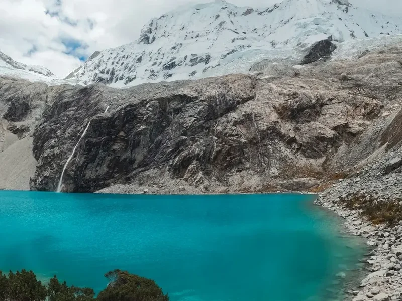
The Laguna 69 Trail is arguably the most iconic day hike in Peru’s Cordillera Blanca, a high-altitude odyssey that leads to a glacial lake of such intense turquoise it appears almost surreal against the backdrop of jagged, snow-capped peaks. Located within the UNESCO-recognised Huascarán National Park, this 13.8-kilometre return journey is a rite of passage for trekkers visiting the mountaineering hub of Huaraz. The trail is a masterclass in Andean geography, winding through glacial valleys, past thundering waterfalls, and beneath the towering presence of some of the highest tropical mountains on Earth, including Huascarán (6,768 m) and Chacraraju (6,112 m). While the distance may seem modest, the true challenge lies in the altitude; the trail begins at approximately 3,900 metres and culminates at the lake’s edge at a staggering 4,600 metres above sea level. This is a landscape where the air is thin, the light is piercingly clear, and the natural beauty is profoundly humbling.
- Distance: 13.8 km return
- Duration: 5–7 hours
- Elevation Gain: 760 m
- Maximum Altitude: 4,600 m
- Difficulty: Challenging (primarily due to altitude)
- Best Time: May to September (the Andean dry season)
- Closest City: Huaraz (3 hours by road)
- Trailhead: Cebollapampa
Overview
The Laguna 69 Trail is frequently described as one of the most beautiful day hikes in the world, and for good reason. The route offers a concentrated dose of everything that makes the Peruvian Andes spectacular: ancient Polylepis forests, meandering glacial streams, grazing livestock in high-altitude meadows, and a constant horizon of ice-clad summits. The hike is a steady ascent that tests both physical stamina and the body’s ability to process oxygen in a depleted environment. It is not merely a walk to a destination, but a journey through a fragile and dramatic ecosystem that has been shaped by millennia of glacial retreat and tectonic activity.
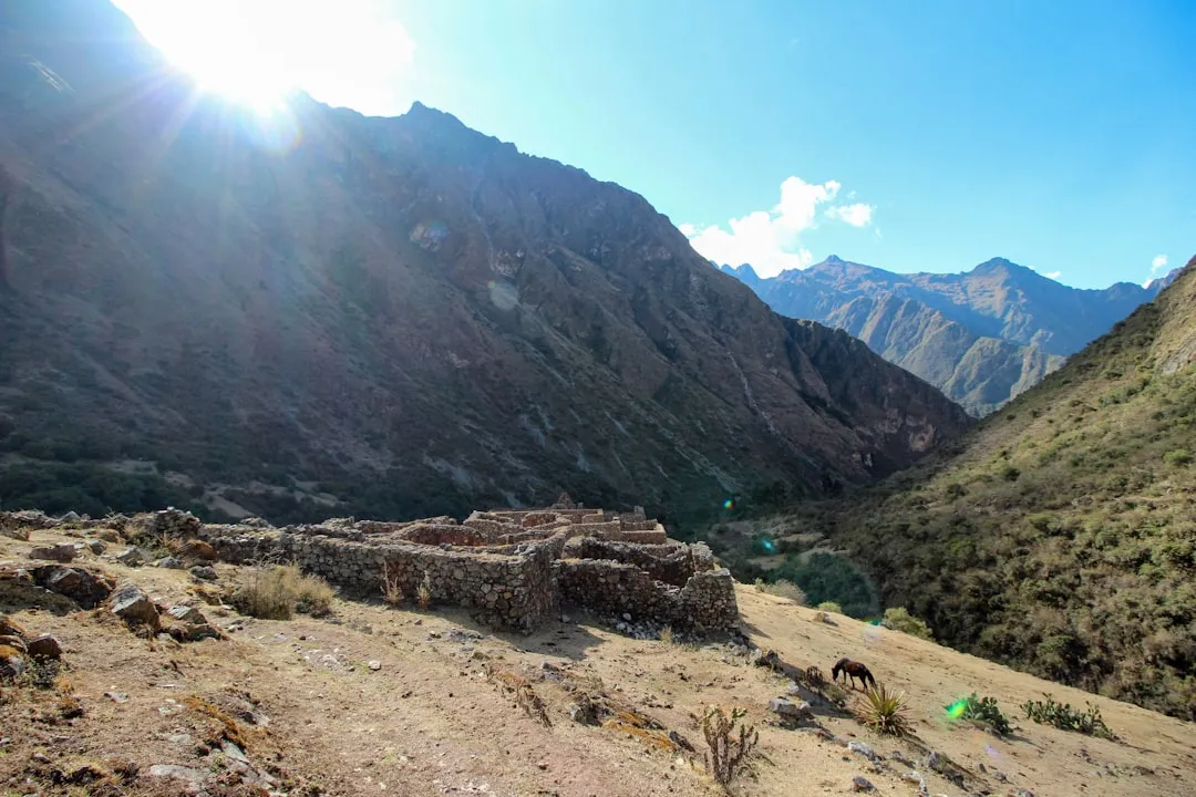
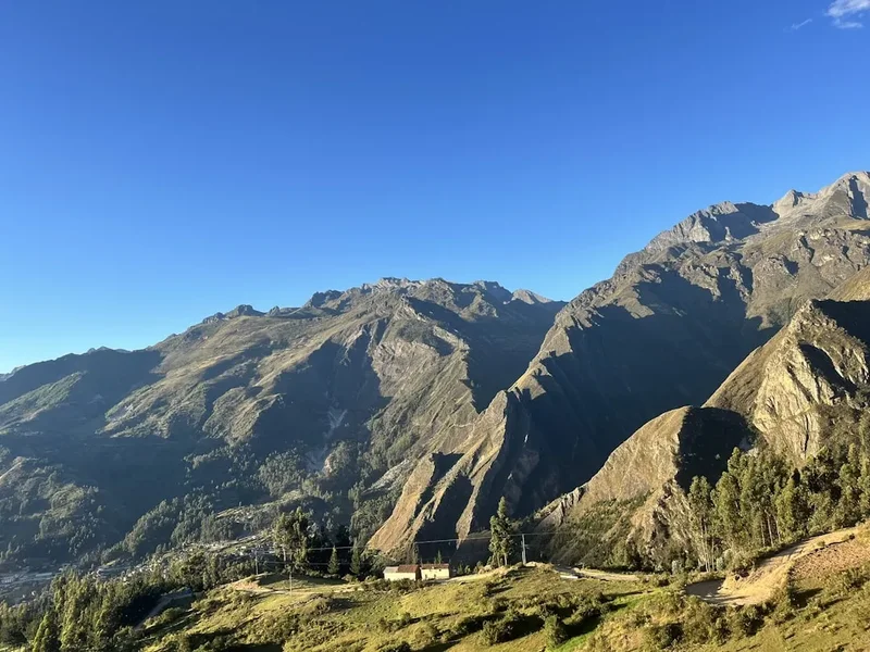
The experience begins long before the first step is taken on the trail. The three-hour drive from Huaraz to the trailhead at Cebollapampa is a scenic adventure in itself, passing through the Callejon de Huaylas and ascending into the heart of the mountains via the Llanganuco Valley. Here, the road skirts the shores of the twin Llanganuco Lakes—Chinancocha and Orconcocha—whose emerald waters provide a stunning prelude to the main event. Once at Cebollapampa, the trail unfolds in three distinct stages: a gentle valley floor warm-up, a steep series of switchbacks leading to a high alpine plateau, and a final, gruelling ascent to the lake itself. The reward for this exertion is a view that defies description: a crystalline lake fed by a hanging glacier, surrounded by a natural amphitheatre of granite and ice. The silence at the top is broken only by the occasional roar of an avalanche on the distant slopes of Chacraraju or the whistle of the Andean wind.
Because of its popularity, the trail can be busy, particularly during the peak months of July and August. However, the sheer scale of the landscape ensures that the sense of wilderness remains intact. For many, Laguna 69 serves as the ultimate acclimatisation hike before embarking on longer multi-day treks like the Santa Cruz or the Huayhuash Circuit. It is a demanding, rewarding, and visually arresting experience that captures the raw essence of the Cordillera Blanca.
History and Cultural Context
The history of Laguna 69 is inextricably linked to the broader history of the Huascarán National Park and the Cordillera Blanca. The park was established in 1975 to protect the unique biodiversity and geological features of the range, which contains the highest concentration of tropical glaciers in the world. In 1985, it was designated a UNESCO World Heritage site, recognising its outstanding natural value. The name "Laguna 69" itself is a reflection of the sheer number of glacial lakes in the region; when the park was being surveyed and mapped, many of the lakes were simply assigned numbers. While some have since been given traditional Quechua names, Laguna 69 has retained its numerical designation, which has become a brand in its own right among the international trekking community.
The region is also steeped in the history of the Chavín culture, one of the oldest and most significant pre-Inca civilisations in Peru, which flourished in the nearby valleys over 3,000 years ago. For the local Quechua-speaking communities, these mountains (or 'Apus') are sacred entities, believed to be the protectors of the land and the sources of life-giving water. The glaciers of the Cordillera Blanca are the primary water source for the arid coastal regions of Peru, making their preservation a matter of national importance. In recent decades, the area has become a focal point for climate change research, as the rapid retreat of glaciers like those feeding Laguna 69 provides a visible and sobering record of global warming.
The trail also passes through areas that have seen significant mountaineering history. The peaks surrounding the lake, such as Pisco and Huandoy, have been the site of numerous first ascents and legendary climbs by international expeditions since the early 20th century. Walking the trail to Laguna 69 is, in many ways, walking in the footsteps of the pioneers of Andean mountaineering, albeit on a much more accessible scale.
Want more background? Read extended notes on history and cultural context → Learn more
Seasonal Highlights and Weather Reality
The weather in the Cordillera Blanca is defined by two distinct seasons: the dry season (known as the "Andean Summer") and the wet season. Understanding these cycles is crucial for a successful and safe hike to Laguna 69.
Dry Season (May to September): This is the prime window for trekking. During these months, the weather is characterised by stable, clear blue skies and intense solar radiation during the day. Visibility is at its peak, offering the best views of the surrounding peaks. However, the clear skies also mean that temperatures drop significantly at night and in the early morning, often falling below freezing. Hikers starting early from Huaraz will experience biting cold at the trailhead, which quickly transitions to heat as the sun rises. This is the most popular time to visit, so expect more company on the trail.
Shoulder Seasons (April and October): These months can be unpredictable. You may experience beautiful clear mornings followed by afternoon rain or snow showers. The landscape is often greener during these periods, and the trail is less crowded, but you must be prepared for rapidly changing conditions. Snow on the trail at higher elevations is more common during these months.
Wet Season (November to March): Hiking to Laguna 69 during the wet season is challenging and often disappointing. Heavy rain, thick mist, and low cloud cover frequently obscure the mountains and the lake itself. The trail can become extremely muddy and slippery, and the risk of rockfall or small landslides increases. While the temperatures are slightly milder than in the dry season, the dampness makes it feel much colder. Most trekking agencies do not run regular tours during the height of the wet season, and independent hikers should exercise extreme caution.
Regardless of the season, weather at 4,600 metres is notoriously fickle. A perfectly clear morning can transform into a localized snowstorm within thirty minutes. Proper layering and waterproof gear are essential year-round.
Recommended Itinerary
Laguna 69 Day Hike Itinerary
Early Morning: Huaraz to Cebollapampa
- 05:00 – 05:30: Departure from Huaraz via private tour bus or colectivo.
- 07:30: Brief stop in Yungay for a quick breakfast (usually coca tea and bread).
- 08:00: Entry into Huascarán National Park; payment of park fees.
- 08:15: Scenic drive through the Llanganuco Valley, passing the turquoise Chinancocha and Orconcocha lakes.
- 09:00: Arrival at Cebollapampa (3,900 m), the official trailhead.
- Final gear check and application of sunscreen before commencing the hike.
Morning: The First Ascent and the High Plateau
- 09:15 – 10:30: The trail begins with a relatively flat section through a valley floor dotted with Polylepis trees and grazing cattle.
- 10:30 – 11:30: The first major climb begins. A series of well-defined switchbacks ascends the valley wall.
- Pass a spectacular waterfall on the right-hand side of the trail, fed by the glaciers above.
- 11:30: Reach a high alpine plateau (Pampa). The trail flattens out significantly here, providing a much-needed reprieve for the lungs.
- Views of the small, darker Laguna Consolación are visible to the left for those who take a short detour.
- The massive granite face of Chacraraju looms directly ahead, growing more imposing with every step.
Midday: The Final Push and Arrival
- 11:45 – 13:00: The final and most difficult section of the hike. The trail steepens considerably as it climbs the final ridge.
- This section is often referred to as "The Switchbacks of Death" by locals, though they are safe, just physically exhausting at 4,500 m.
- 13:00: Arrival at Laguna 69 (4,600 m). The first view of the lake is a sudden, breathtaking explosion of colour.
- Spend 45–60 minutes at the lake. This is the time for lunch, photography, and simply absorbing the silence of the high Andes.
- Observe the hanging glaciers of Chacraraju and listen for the sound of ice cracking.
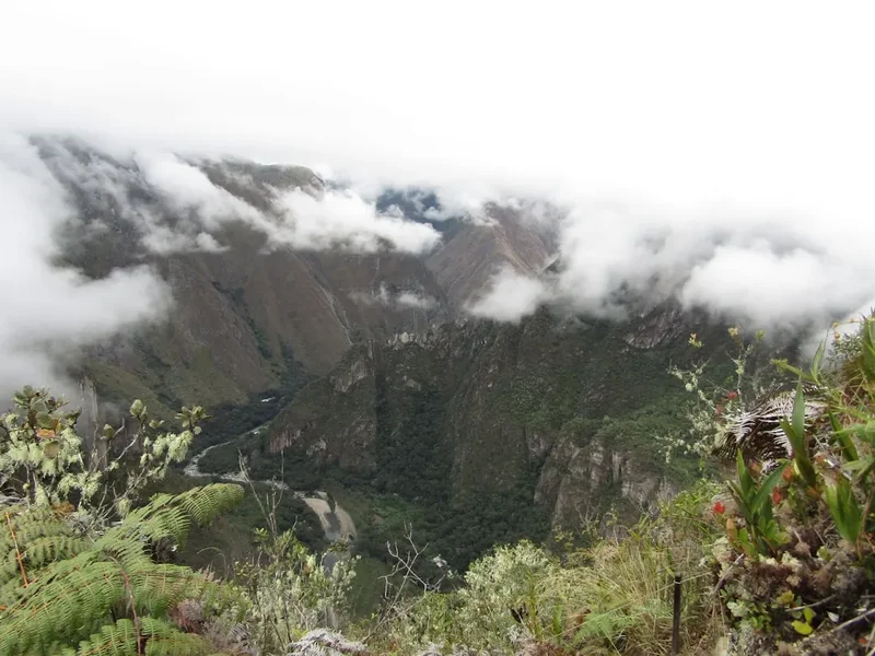
- Note: Do not stay too long if clouds begin to roll in, as visibility can vanish quickly.
Afternoon: The Descent and Return to Huaraz
- 14:00: Begin the descent back to Cebollapampa. While easier on the lungs, the descent is taxing on the knees.
- 16:00 – 16:30: Arrival back at the trailhead at Cebollapampa.
- 17:00: Board transport for the return journey to Huaraz.
- 19:00 – 20:00: Arrival back in Huaraz for a well-earned dinner.
Important Notes:
- The times provided are averages; those struggling with altitude may take longer.
- Always keep the transport departure time in mind; colectivos and tour buses usually depart Cebollapampa by 16:30.
- The trail is well-marked, but in thick mist, it is possible to lose the path on the rocky sections near the top.
- Hydration is critical during the descent to prevent altitude-induced headaches.
Planning and Bookings
Book Your Trip
Everything you need to plan your journey
Accommodation
Find places to stay near Huaraz
Flights
Search flights to Huaraz
Essential Preparation
The single most important aspect of preparing for Laguna 69 is acclimatisation. Attempting this hike on your first or second day in Huaraz is a recipe for failure and potentially dangerous altitude sickness. Most experienced hikers recommend spending at least two to three days at altitude before tackling Laguna 69. Recommended warm-up hikes include Laguna Wilcacocha (3,700 m) or Laguna Churup (4,450 m), though Churup is also quite demanding.
Logistically, you have two main options for reaching the trailhead: an organised tour or independent travel via colectivo. Tours are inexpensive (typically S/ 40–60) and provide door-to-door transport, which is convenient given the 5:00 AM start. However, you are tied to the group’s schedule. Independent travel involves taking a colectivo from Huaraz to Yungay, and then another from Yungay to Cebollapampa. This offers more flexibility but requires more effort and can be difficult to coordinate for the return journey if you are late.
Huaraz is the primary base for all logistics. It is a bustling city with a wide range of accommodation, from budget hostels to comfortable hotels. There are numerous outdoor shops where you can rent gear (poles, jackets, etc.) and supermarkets to stock up on supplies. Ensure you have enough Peruvian Soles in cash, as many small operators and the national park entrance do not accept cards.
Trail Accommodation
This is a day hike requiring no overnight accommodation. The trail is designed to be completed within a single day, and camping at Laguna 69 itself is generally discouraged to protect the fragile environment and because of the extreme cold and wind at 4,600 metres. Most hikers return to Huaraz for the night.
For those embarking on the multi-day Santa Cruz trek, Cebollapampa serves as a common camping spot. There are basic, flat areas near the trailhead where tents can be pitched, but there are no facilities other than the natural environment. If you choose to camp at Cebollapampa, you must be self-sufficient with all gear and food. There are no huts or shelters along the Laguna 69 trail itself.
Required Gear
- Hiking Boots: Sturdy, waterproof boots with good ankle support are essential. The trail is rocky and can be muddy or snowy.
- Layered Clothing: A moisture-wicking base layer, a warm fleece or down mid-layer, and a high-quality waterproof/windproof outer shell.
- Hiking Trousers: Quick-drying trekking trousers. Avoid jeans, which become heavy and cold when wet.
- Sun Protection: A wide-brimmed hat, high-SPF sunscreen, and UV-protection sunglasses. The Andean sun is exceptionally strong at this altitude.
- Gloves and Beanie: Essential for the cold morning start and the windy conditions at the lake.
- Daypack: A 20–30L pack with a rain cover to carry your gear and supplies.
- Trekking Poles: Highly recommended to assist with the steep ascent and to protect your knees during the 760 m descent.
- Head Torch: Always carry one in case of unexpected delays that result in hiking near dusk.
What to Bring
- Water: At least 2–3 litres per person. Dehydration significantly worsens the effects of altitude.
- Water Treatment: If you plan to refill from streams, use a filter or purification tablets. While the water looks pristine, livestock graze in the area.
- High-Energy Food: Pack a substantial lunch plus snacks like nuts, chocolate, energy bars, and fruit. Your body burns more calories at altitude.
- Coca Leaves or Tablets: Many locals and hikers swear by chewing coca leaves or drinking coca tea to alleviate altitude symptoms. Sorojchi Pills are also available in Huaraz pharmacies.
- Personal First Aid: Include blister plasters, ibuprofen/paracetamol for headaches, and any personal medications.
- Toilet Paper and Sanitiser: There are no toilets on the trail; you must be prepared to pack out all waste.
- Cash: Small denominations for the park entrance fee (S/ 30 for a day pass) and any snacks in Yungay.
- Identification: A copy of your passport is often required for the national park registration.
Permits
To hike Laguna 69, you must pay an entrance fee to the Huascarán National Park (Parque Nacional Huascarán). There is no need to book a specific "permit" months in advance, unlike the Inca Trail, but you must ensure you have the correct ticket (Boleto Turístico).
Fee Structure:
- One-day pass: S/ 30 per person. This is valid for a single entry and is the standard choice for Laguna 69.
- Multi-day pass (up to 3 days): S/ 60 per person. Ideal if you plan to do another hike (like Pastoruri Glacier) within a 72-hour window.
- Long-stay pass (up to 30 days): S/ 150 per person. This is the best value for those planning to do the Santa Cruz or Huayhuash treks.
Where to Buy: Tickets are typically purchased in cash at the park control point in the Llanganuco Valley as you drive towards the trailhead. If you are on an organised tour, the guide will usually collect the money and handle the transaction for the group. Ensure you keep your ticket stub, as rangers may check it at the trailhead or during the hike.
Regulations: The park is managed by SERNANP (Servicio Nacional de Áreas Naturales Protegidas por el Estado). Regulations are strictly enforced to preserve the ecosystem. You must stay on the marked trails, and the removal of any flora, fauna, or minerals is strictly prohibited. Drones are generally not permitted without a specific, pre-arranged commercial permit, which is difficult to obtain.
Other Activities in the Area
Huaraz is the "Trekking Capital of Peru," and there are numerous other activities to complement your Laguna 69 experience:
- Santa Cruz Trek: A world-famous 4-day trek that passes through the heart of the Cordillera Blanca, offering even more expansive views than Laguna 69.
- Pastoruri Glacier: A high-altitude (5,000 m+) visit to a receding glacier. It is less of a hike and more of a scenic walk, making it a good "rest day" activity.
- Chavín de Huántar: An archaeological site located a few hours from Huaraz. It was the religious and political centre of the Chavín culture and features impressive stone carvings and underground tunnels.
- Laguna Churup: A challenging day hike to a beautiful lake closer to Huaraz. It involves some light scrambling with fixed cables.
- Rock Climbing in Hatun Machay: A "stone forest" offering world-class sport climbing at high altitude.
- Wilcacocha Sunset: A short, easy hike to a lake in the Cordillera Negra, offering the best panoramic views of the entire Cordillera Blanca range as the sun sets.
Safety and Conditions
Altitude Sickness (AMS): This is the primary safety concern. At 4,600 metres, the effective oxygen level is significantly lower than at sea level. Symptoms of Acute Mountain Sickness (AMS) include severe headache, nausea, dizziness, and extreme fatigue. If you experience these symptoms, the only cure is to descend immediately. Do not "push through" severe symptoms, as they can escalate into life-threatening conditions like HAPE (High Altitude Pulmonary Edema) or HACE (High Altitude Cerebral Edema).
Hydration and Nutrition: Drink significantly more water than you think you need. The dry mountain air and increased respiration rate lead to rapid fluid loss. Eat small, frequent snacks rich in carbohydrates to maintain energy levels. Avoid alcohol and heavy meals the night before the hike.
Weather Hazards: Hypothermia is a risk even in the dry season if you are caught in rain or snow without proper gear. The temperature can drop 10–15 degrees Celsius in minutes if the sun goes behind a cloud or the wind picks up. Always carry a waterproof layer and a warm hat.
Sun Exposure: The UV index at 4,600 m in the tropics is extreme. Severe sunburn can occur in less than 30 minutes. Apply high-SPF sunscreen to all exposed skin, including the underside of your nose and chin (reflected light from snow or water), and wear UV-rated sunglasses to prevent snow blindness.
Trail Conditions: The trail is generally well-maintained but can be slippery when wet. Watch your footing on the scree slopes and the final rocky ascent. If hiking independently, ensure someone knows your plans and your expected return time, as mobile signal is non-existent once you enter the Llanganuco Valley.
Side Trips and Points of Interest
Mirador Pisco: For those with exceptional fitness and extra time, a detour towards the Base Camp for Nevado Pisco offers even more dramatic views of the Huandoy peaks. This adds significant distance and elevation and should only be attempted by those who are very well-acclimatised.
Laguna Consolación: Located on the plateau before the final ascent to Laguna 69, this smaller, shallower lake is often overlooked. It is a peaceful spot and offers a different perspective of the valley. It is only a 10-minute detour from the main path.
The Llanganuco Lakes: While technically passed on the drive in, many people ask their driver to stop for 15 minutes on the return journey. The colour of these lakes (Chinancocha and Orconcocha) is a deeper emerald green compared to the turquoise of Laguna 69, providing a beautiful contrast.
Polylepis Forests: The lower sections of the trail pass through groves of ancient Polylepis trees, known locally as 'Queñua'. These trees are unique for their papery, reddish bark and their ability to grow at higher altitudes than almost any other tree species in the world. They are a vital part of the high-altitude ecosystem, providing habitat for rare bird species.
Leave No Trace
The Huascarán National Park is a fragile high-altitude desert and glacial environment. The influx of thousands of hikers every year puts significant pressure on this ecosystem. It is the responsibility of every visitor to minimise their impact.
Core Principles for Laguna 69:
- Pack it in, pack it out: This includes all organic waste like banana peels and orange pips, which do not decompose quickly in the cold, thin air.
- Stay on the trail: Braiding trails (creating multiple paths) causes soil erosion and destroys delicate alpine flora that can take years to grow just a few centimetres.
- Respect the water: Do not wash yourself or your dishes in the lake or streams. Do not use the lake as a toilet. The water from these glaciers is a primary source for communities downstream.
- No campfires: Wood is scarce and the Polylepis trees are protected. Use a stove if you are camping at Cebollapampa.
- Wildlife: Observe vizcachas (Andean rodents that look like rabbits with long tails) and birds from a distance. Never feed them.
- Human Waste: There are no toilets. If you must go, move at least 60 metres from water sources and trails, dig a hole 15cm deep, and pack out your used toilet paper in a sealed bag.