La Jonction - A Journey to the Heart of the Glaciers
La Jonction is one of the most visually spectacular day hikes in the Chamonix Valley, offering an unparalleled front-row seat to the dramatic meeting point of two mighty rivers of ice: the Glacier des Bossons and the Glacier de Taconnaz. Located in the Haute-Savoie region of the French Alps, this trail takes hikers from the lush, forested floor of the Arve Valley up to a rocky promontory at 2,589 metres, where the ice splits around a prow of ancient stone. It is a place of raw, geological power, where the groans of shifting ice and the sight of towering blue seracs create an atmosphere of high-alpine drama. Unlike many trails that offer distant views of the Mont Blanc massif, La Jonction places you directly alongside the frozen cascades that have defined the history of mountaineering for centuries. This is a walk that demands steady footing and a respect for the elements, rewarding the adventurous with a perspective usually reserved for elite alpinists.
- Distance: 12.0 km return
- Duration: 4-5 hours
- Elevation Gain: 600 m
- Difficulty: Moderate
- Best Time: May to October
- Closest City: Chamonix, France
- Trailhead: Parking du Glacier des Bossons
Overview
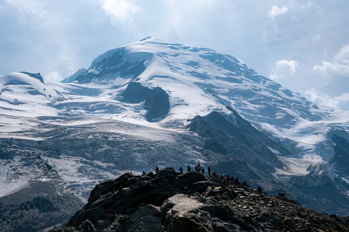
The La Jonction trail is a masterclass in vertical transition. Starting in the cool, shaded larch and spruce forests above the village of Les Bossons, the path climbs steadily, shedding the canopy to reveal the staggering scale of the Mont Blanc massif. The "Junction" itself refers to the specific point where the Bossons and Taconnaz glaciers diverge as they flow down from the heights of the Dôme du Goûter and the Aiguille du Goûter. Standing at the summit of the hike, you are flanked by two chaotic icefalls, a labyrinth of crevasses and ice towers that seem to frozen in mid-tumble. The contrast between the dark, weathered rock of the ridge and the brilliant, translucent whites and blues of the glaciers is one of the most striking sights in the entire Alps.
The hike is historically significant as it follows the original route taken by the pioneers of the first ascent of Mont Blanc in 1786. While the modern route is well-marked and maintained, it retains a sense of ruggedness. The terrain evolves from soft forest floor to rocky switchbacks, eventually culminating in a final scramble over granite slabs. The 600 metres of elevation gain are concentrated, ensuring a consistent workout that keeps the heart rate elevated while the scenery provides constant distraction. Throughout the ascent, the Aiguilles de Chamonix—the jagged granite needles that pierce the sky above the valley—serve as a dramatic backdrop, their shapes shifting and becoming more imposing as you gain height.
For those visiting Chamonix, La Jonction offers a more intimate and visceral experience than the crowded cable cars of the Aiguille du Midi. It is a physical journey that connects the hiker to the landscape through effort and observation. On a clear day, the sun reflects off the ice with blinding intensity, and the sound of meltwater rushing beneath the glaciers provides a constant soundtrack. It is a hike of contrasts: the stillness of the high peaks against the slow, grinding movement of the ice; the warmth of the summer sun against the cold breath of the glaciers. Whether you are a seasoned hiker or a fit enthusiast, La Jonction provides a profound sense of achievement and a deep appreciation for the glacial forces that have carved the European continent.
History and Cultural Context
The history of La Jonction is inextricably linked to the birth of modern mountaineering. In August 1786, Jacques Balmat and Michel-Gabriel Paccard passed through this very area during their historic first ascent of Mont Blanc. At the time, the glaciers were significantly larger than they are today, extending much further down into the valley. The "Gîte à Balmat," a natural rock shelter near the summit of the hike, served as a bivouac site for early explorers, providing a meagre shield against the alpine elements. Walking this trail is, in many ways, a pilgrimage through the annals of exploration, following the footsteps of those who first looked at the highest peak in Western Europe and dared to climb it.
The Glacier des Bossons itself holds a somber place in aviation history. It was the site of two major air disasters involving Air India flights: the Malabar Princess in 1950 and the Kanchenjunga in 1966. Over the decades, the slow movement of the glacier has occasionally yielded artifacts from these wrecks—pieces of fuselage, engine parts, and even personal effects—which are transported down the mountain by the ice. This "conveyor belt" effect of the glacier serves as a haunting reminder of the mountain's power and the passage of time. Local museums in Chamonix house many of these finds, providing a link between the high-altitude world and the valley below.
Culturally, the Chamonix Valley has transformed from a remote collection of farming hamlets into the world's premier mountain sports hub. The development of the trail to La Jonction reflects this evolution. What was once a treacherous route for crystal hunters and early scientists is now a celebrated hiking path. However, the local community remains deeply connected to the mountain's heritage. The mountain guides of Chamonix, the oldest such professional body in the world, still use these slopes for training and historical tours. The trail is not just a recreational path; it is a living museum of human ambition and the enduring allure of the high Alps.
Want more background? Read extended notes on history and cultural context → Learn more
Seasonal Highlights and Weather Reality
The hiking season for La Jonction typically runs from late May to October, though this is heavily dependent on the previous winter's snowfall and the rate of spring melt. In early summer (May and June), the higher reaches of the trail may still be covered in snow patches, requiring caution and potentially the use of trekking poles or traction aids. This period is particularly beautiful as the alpine wildflowers begin to bloom in the lower meadows, and the glaciers are at their most pristine, still covered in a layer of winter white before the summer sun exposes the darker ice beneath.
July and August are the peak months for the trail. The weather is generally stable, with long, sunny days and warm temperatures. However, the Chamonix Valley is prone to sudden afternoon thunderstorms. Hikers should aim for an early start to ensure they are off the exposed upper ridges before any potential electrical activity begins. The heat of mid-summer also increases the activity of the glaciers; it is during these months that you are most likely to hear the thunderous "crack" of shifting ice or see small serac falls in the distance. The clarity of the air in summer provides the best photographic opportunities, with the deep blue of the sky contrasting sharply against the white peaks.
September and October offer a different, more tranquil experience. The summer crowds have thinned, and the air takes on a crisp, cool edge. The deciduous trees in the valley begin to turn gold and orange, creating a stunning frame for the glaciers. While the days are shorter, the light is softer and more golden, particularly in the late afternoon. Snow can return to the peaks as early as late September, so hikers must be prepared for colder temperatures and the possibility of icy patches on the trail. By November, the trail is usually reclaimed by winter, becoming the domain of ski tourers and mountaineers equipped for full winter conditions.
Recommended Itinerary
La Jonction Day Hike Itinerary
Early Morning: Departure and Forest Ascent
- Distance: 2.5 km
- Elevation gain: 250 m
- Time: 1 hour
- Start at the Parking du Glacier des Bossons (approx. 1,000 m).
- Follow the well-marked signs for "La Jonction" and "Chalet des Bossons."
- The trail begins with a series of zig-zags through a dense forest of larch and fir.
- Arrive at the Chalet des Bossons (1,225 m), a perfect spot for a quick coffee with a view of the glacier's snout.
- The air is cool and damp here, scented with pine and the proximity of the ice.
Morning: The Mid-Mountain Traverse
- Distance: 2.5 km
- Elevation gain: 200 m
- Time: 1.5 hours
- Continue climbing above the chalet towards the Chalet des Pyramides.
- The forest begins to thin, replaced by alpine shrubs and rocky outcrops.
- The trail offers increasingly dramatic views of the seracs of the Glacier des Bossons to your left.
- Reach the Chalet des Pyramides (1,895 m). This is a significant landmark and a good place for a sustained break.
- From here, the "pyramides"—large rock formations shaped by glacial action—are clearly visible.
Midday: The Final Push to La Jonction
- Distance: 1 km
- Elevation gain: 150 m
- Time: 1 hour
- The terrain becomes more rugged and "alpine" in character.
- Follow the ridge line, navigating sections of granite slabs and stable scree.
- Pass the "Gîte à Balmat," the historic rock shelter used by early explorers.
- The final approach involves some light scrambling (no technical equipment required, but hands may be needed for balance).
- Arrive at La Jonction (2,589 m), the rocky prow between the two glaciers.
- Spend time absorbing the 360-degree views of Mont Blanc, the Aiguille du Midi, and the chaotic ice fields below.
Afternoon: Descent to Les Bossons
- Distance: 6 km
- Elevation loss: 600 m
- Time: 1.5–2 hours
- Retrace your steps carefully down the ridge.
- The descent requires focus, particularly on the rocky sections which can be slippery if damp.
- Stop at the Chalet des Pyramides or Chalet des Bossons for a celebratory drink or snack.
- Return to the parking area by mid-to-late afternoon.
- The changing light of the afternoon provides a different perspective on the valley and the surrounding peaks.
Important Notes:
- The trail is a return route; ensure you leave enough time for the descent before sunset.
- Water is available at the chalets (check seasonal opening), but carry at least 2 litres.
- The upper section is exposed to sun and wind; adjust layers accordingly.
- Check the local Chamonix weather forecast (Météo-France) before starting.
- The trail is well-signposted with yellow diamond markers and directional signs.
Planning and Bookings
Book Your Trip
Everything you need to plan your journey
Accommodation
Find places to stay near Chamonix
Flights
Search flights to Chamonix
Essential Preparation
La Jonction is a demanding day hike that requires a good level of physical fitness. While the distance is moderate at 12 kilometres, the 600 metres of elevation gain are concentrated, and the terrain becomes increasingly technical towards the summit. Hikers should be comfortable with steep ascents and walking on uneven, rocky surfaces. It is highly recommended to spend at least one or two days in Chamonix (1,035 m) prior to the hike to acclimatise to the altitude, as the summit reaches nearly 2,600 metres.
Chamonix-Mont-Blanc serves as the primary base for this hike. The town is world-renowned for its outdoor infrastructure, offering a wide range of accommodation from campsites and hostels to luxury hotels. There are numerous outdoor retailers where gear can be purchased or rented, and the local supermarkets are well-stocked for trail supplies. Transport to the trailhead is straightforward; the "Le Bossons" train station and local bus stops are within walking distance of the trailhead, though a car provides the most flexibility.
Trail Accommodation
This is a day hike requiring no overnight accommodation on the trail itself. The route is designed to be completed within 4 to 6 hours, allowing hikers to return to Chamonix or Les Bossons for the evening. There are no mountain huts (refuges) offering overnight stays on this specific path.
However, there are two private chalets located along the route that provide daytime services:
- Chalet des Bossons (1,225 m): Typically open from June to September. Offers snacks, drinks, and light meals. It features a terrace with exceptional views of the glacier snout. No overnight stays.
- Chalet des Pyramides (1,895 m): A rustic mountain hut offering refreshments and simple food. It is a popular turnaround point for those not wishing to complete the full ascent to La Jonction. No overnight stays.
For those wishing to stay as close to the trailhead as possible, the village of Les Bossons offers several hotels and guesthouses, as well as a well-equipped campsite (Camping des Deux Glaciers) located near the base of the trail.
Required Gear
- Hiking Boots: Sturdy, waterproof boots with good ankle support and a high-grip sole (Vibram or similar) are essential for the rocky upper sections.
- Clothing: A layering system is key. Include a moisture-wicking base layer, an insulating mid-layer (fleece or light down), and a breathable, windproof outer shell.
- Waterproof Jacket: Even on clear days, mountain weather is unpredictable. A high-quality waterproof jacket is mandatory.
- Trekking Poles: Highly recommended to assist with the steep ascent and to reduce impact on knees during the 600 m descent.
- Backpack: A 20-30 litre daypack with a rain cover.
- Navigation: A physical map (IGN 3630 OT Chamonix is the standard) and a compass, or a reliable GPS app with offline maps.
- Sun Protection: High-factor sunscreen (SPF 50+), a wide-brimmed hat, and Category 3 or 4 sunglasses to protect against intense alpine glare.
What to Bring
- Water: At least 2 litres per person. While water can be purchased at the chalets, it is not guaranteed they will be open or have supplies.
- Food: High-energy snacks (nuts, dried fruit, energy bars) and a substantial lunch. There are no food sources beyond the Chalet des Pyramides.
- First Aid Kit: Including blister plasters, antiseptic wipes, bandages, and any personal medications.
- Emergency Gear: A lightweight emergency bivy bag or space blanket, and a whistle.
- Head Torch: Even on a day hike, carry a light in case of unexpected delays.
- Mobile Phone: Fully charged, with the local emergency number (112) saved. Note that signal can be intermittent in deep gullies.
- Waste Bags: To carry out all rubbish, including organic waste like fruit peels.
Permits
One of the many appeals of the La Jonction trail is its accessibility. Currently, no permits are required to hike this route, and there are no trail fees or access charges for independent hikers. The trail is located within the public domain of the Chamonix Valley and is maintained by the local municipality and the Section des Sentiers.
Access and Parking:
- Parking: The Parking du Glacier des Bossons is free of charge, though it can fill up quickly during the peak summer months of July and August. It is advisable to arrive before 8:30 AM to secure a spot.
- Public Transport: The Chamonix Bus (Line 1) serves the Les Bossons area regularly. From the bus stop, it is a short, well-signposted walk to the trailhead. The Mont Blanc Express train also stops at Les Bossons station, providing easy access from Chamonix centre or further down the valley.
- Group Sizes: While there are no formal limits on group sizes, it is requested that large organised groups (10+ people) be mindful of other trail users and the fragile alpine environment.
Regulations:
- Wild Camping: Bivouacking (setting up a tent from sunset to sunrise) is generally tolerated in the high mountains of France above the treeline, but it is discouraged on the La Jonction route due to the proximity of the glaciers and the risk of rockfall. It is strictly forbidden near the chalets or in the forested lower sections.
- Dogs: Dogs are permitted on the trail but must be kept under strict control. In the higher, rocky sections, the terrain may be difficult for some dogs, and the presence of local wildlife (chamois and marmots) requires owners to be vigilant.
- Drones: The use of drones is strictly regulated in the Chamonix Valley, particularly near the Mont Blanc massif and within the various nature reserves. Always check current local prefectural decrees before flying.
Other Activities in the Area
Chamonix is the adventure capital of Europe, and there are countless ways to complement your hike to La Jonction:
- Aiguille du Midi: Take the world-famous cable car to 3,842 m for a stunning view of Mont Blanc and the "Step into the Void" glass skywalk. This provides a bird's-eye view of the glaciers you walked alongside.
- Mer de Glace and Train du Montenvers: Visit France's largest glacier via a historic rack-and-pinion railway. Explore the ice cave carved into the heart of the glacier and visit the Glaciorium to learn about climate change.
- Paragliding: Experience the valley from the air. Tandem flights often depart from Planpraz or Les Grands Montets, offering a unique perspective on the jagged peaks and frozen valleys.
- QC Terme Chamonix: Relax your muscles after the hike at this luxury thermal spa, which features outdoor heated pools with direct views of the Mont Blanc massif.
- Alpine Museum: Located in the centre of Chamonix, this museum provides deep insights into the history of the valley, from early tourism to the evolution of mountaineering equipment.
- Rock Climbing: The valley is home to world-class climbing. Beginners can try the "Les Gaillands" climbing crag, which offers routes for all levels with a beautiful lakeside setting.
Safety and Conditions
Alpine Environment Hazards:
The La Jonction trail reaches high-alpine terrain where conditions can change with startling speed. Even if the valley is warm and calm, the summit at 2,589 m can be subjected to high winds and significantly lower temperatures. Hypothermia is a genuine risk if you are not prepared with appropriate layers. The final section of the hike involves navigating granite slabs; while not technically difficult, these can become extremely slippery when wet or icy. Always test your footing and use your hands for stability where necessary.
Glacial Proximity:
The primary draw of this hike—the proximity to the glaciers—is also a source of objective danger. You must stay on the marked trail at all times. Do not attempt to walk onto the glaciers (Glacier des Bossons or Glacier de Taconnaz) without professional guiding and full mountaineering equipment (crampons, ice axe, rope, and harness). The ice is riddled with hidden crevasses, and the seracs (ice towers) are unstable and can collapse without warning. The "Junction" is a safe viewing point, but the ice itself is a strictly expert-only environment.
Weather Monitoring:
Before departing, check the specialized mountain forecast provided by Météo-France for the Chamonix-Mont-Blanc area. Pay close attention to the "Isotherme 0°C" (the altitude at which temperatures drop below freezing) and the wind speed at 2,500 m. If thunderstorms are forecast, do not attempt the hike. The upper ridge is highly exposed and acts as a natural lightning rod. If you see dark clouds building or feel the air "humming," descend immediately to the safety of the forest.
Hydration and Altitude:
The combination of physical exertion and altitude increases the risk of dehydration and altitude sickness. Symptoms of the latter include headache, nausea, and dizziness. If you experience these, stop, hydrate, and if symptoms persist, descend. Drink water regularly, even if you do not feel thirsty, as the dry alpine air accelerates fluid loss.
Emergency Contacts:
In the event of an accident, the European emergency number is 112. For specific mountain rescue in the French Alps, the PGHM (Peloton de Gendarmerie de Haute Montagne) in Chamonix is the primary responding body. Ensure your phone is charged and consider carrying a secondary power bank.
Side Trips and Points of Interest
The Gîte à Balmat: Located near the final ascent to La Jonction, this natural rock overhang is a site of immense historical importance. It was used as a shelter by Jacques Balmat and Michel-Gabriel Paccard during the first successful attempt on Mont Blanc in 1786. Standing beneath the rock, one can only imagine the courage and hardiness required to spend a night in such an exposed location with the primitive gear of the 18th century. It is a quiet place for reflection on the evolution of the sport.
The Seracs of the Bossons: While not a "side trip" in the traditional sense, taking the time to find a safe vantage point to observe the seracs is a highlight of the hike. These massive blocks of ice are formed where the glacier flows over a steep drop in the underlying bedrock. The pressure causes the ice to shatter into towers and deep crevasses. From the trail, you can see the intense blue light refracted through the deep ice, a phenomenon caused by the extreme compression of air bubbles over centuries.
Chalet des Pyramides Viewpoint: For those who may find the final scramble to La Jonction too daunting, the area around the Chalet des Pyramides offers a spectacular alternative. There are several small rocky knolls nearby that provide a panoramic view of the "Pyramides"—the jagged rock fins that give the chalet its name. These formations are excellent examples of glacial erosion, where the ice has scoured the rock into sharp, vertical shapes.
The Glacier Snout (Le Criou): At the very beginning of the hike, a short detour leads to a viewpoint overlooking the snout of the Glacier des Bossons. This is one of the few places in the Alps where you can see a glacier terminating so close to a valley floor. Information boards here explain the rapid retreat of the glacier over the last century, providing a sobering look at the impacts of climate change on the alpine landscape.
Leave No Trace
The alpine environment above Chamonix is a fragile ecosystem that faces significant pressure from high visitor numbers. The flora at high altitudes, such as the delicate alpine linaria and various mosses, grows extremely slowly due to the short growing season and harsh conditions. A single footstep off the trail can destroy plants that have taken years to establish. By following Leave No Trace principles, you help ensure that La Jonction remains a pristine wilderness for future generations.
Core Principles for La Jonction:
- Plan Ahead and Prepare: Check weather, carry appropriate gear, and know your limits to avoid the need for rescue, which can have a significant environmental impact.
- Travel on Durable Surfaces: Stay strictly on the marked path. Avoid cutting switchbacks, which causes erosion and damages the trail's integrity.
- Dispose of Waste Properly: Pack out all rubbish, including "biodegradable" items like banana skins or orange peels, which do not decompose in the cold, high-altitude environment and can be harmful to local wildlife.
- Leave What You Find: Do not pick wildflowers or remove rocks. The "crystals" sometimes found in the area are part of the geological heritage and should be left in place.
- Respect Wildlife: The area is home to chamois, bouquetin (ibex), and marmots. Observe them from a distance and never attempt to feed them.
- Be Considerate of Others: Keep noise levels down to preserve the sense of solitude. Yield to uphill hikers and keep groups small.
The glaciers are retreating at an alarming rate. Walking this trail is a privilege that comes with the responsibility of being a steward for the mountain. Leave only footprints, take only photographs, and keep the spirit of the wilderness alive.